Consumer
Outdoor Recreation Handheld
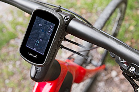
Garmin’s eTrex Touch 25, 35 and 35t outdoor handhelds have an updated user interface and 2.6-inch capacitive touchscreen display. The eTrex Touch series also features activity profiles for navigation for multiple activities and an enhanced track manager to start and stop recording.
The eTrex Touch series has a high-sensitivity, WAAS-enabled GPS receiver with GLONASS support and HotFix satellite prediction to locate users’ position quickly and precisely, even in heavy cover and deep canyons. All units have a three-axis tilt-compensated electronic compass, which gives directional information even when standing still. The eTrex 35 and 35t also have a barometric altimeter to get more accurate altitude, elevation and climb information, as well as indications of weather changes.
Garmin, www.garmin.com
 Fleet Management
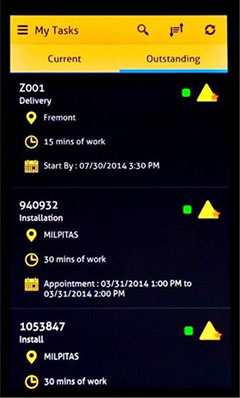
Supervisor App for Fleets
The Supervisor app for the FieldMaster suite of mobile applications allows managers to leave the office and still have visibility into their fleet and mobile workers from their smartphone or tablet, as well as manage day-to-day operations remotely.
FieldMaster Supervisor is available with Trimble Fleet Management and Work Management. Features include viewing the team’s locations on a map; seeing their job progress, including tasks at risk; finding the nearest worker to another team member or customer; turn-by-turn navigation; inspecting job performance and documenting status in the field; and receiving vehicle and driver performance alerts in real-time.
Trimble, www.trimble.com
Defense
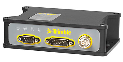
SAASM Receiver
 NovAtel’s SPAN GNSS/INS technology is now available on the company’s OEM625S dual-frequency SAASM GPS plus civil RTK receiver. SPAN offers system developers with SAASM requirements the benefit of continuously available 3D positioning, velocity and attitude (roll, pitch, yaw) for their defense applications. Authorized defense customers need access to the Precise Positioning Service (PPS) for DOD applications. When keyed, the existing OEM625S board-level receiver provides an RTK PPS solution by taking the raw measurements from an L-3 XFACTOR SAASM and applying them to NovAtel’s RTK algorithm. SPAN technology couples NovAtel’s precision GNSS receivers with robust IMUs to provide a more reliable, stable solution, even during short periods of time when satellite signals are blocked or unavailable.
NovAtel, www.novatel.com
Design & Test
Record and Playback with Real Time
 The Averna RP-6100 series is an RF tool offering high-performance record-and-playback and real-time simulation in one platform for RF application validation.
The RP-6100 can capture all GNSS bands, as well as HD Radio, Wi-Fi, LTE, radar, and cognitive radio — plus impairments — to advance RF projects and harden product designs. It features up to four channels, 160 MHz of recording bandwidth, tight channel synchronization, an extended frequency range of 10 MHz to 6 GHz and 14-bit resolution. The RP-6100 can be equipped with Skydel Solutions’ software-defined, real-time GNSS simulator, which delivers easy setups, integrated maps, dynamic scenario creation, high precision and tight parameter controls to enable highly repeatable simulations of current and future GNSS conditions, as well as corner cases.
Averna, www.averna.com
Mobile
Internet of Things Platform
The AirPrime WP Series of smart wireless modules is designed for the development of connected products. The WP Series provides an integrated device-to-cloud architecture enabling developers to build a Linux-based product using a single module that sends user and product data to the cloud. The AirPrime WP series offers an application processor, GNSS receiver, and cellular modem with an optional ultra-low power mode that reduces power consumption by 200 times, opening up new use-case possibilities for cellular connectivity.
Sierra Wireless, www.sierrawireless.com