Tag: Trimble

  • Trimble VRS Now Service Available in Australia, Oregon

    Trimble VRS Now Service Available in Australia, Oregon

    Trimble VRS Now coverage in Australia. Photo: Trimble
    Trimble VRS Now coverage in Australia. Photo: Trimble

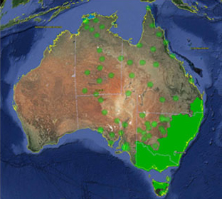
    Trimble, together with its distribution partner Ultimate Positioning Group, announced the availability of Trimble VRS Now correction service in Queensland, New South Wales, South Australia, Tasmania and Victoria.

    Trimble is also now offering the Trimble VRS Now correction service in Oregon’s Willamette Valley.

    The commercial subscription service provides surveyors, civil engineers, geospatial professionals and other industry specialists in these areas with instant access to real-time kinematic (RTK) GNSS corrections without the need for a base station.

    Using both GPS and GLONASS constellations, the Trimble service delivers centimeter-level RTK corrections customized for each GNSS receiver’s location anywhere in the network via cellular communications. The Trimble VRS Now service supplies accurate, reliable and easy-to-use GNSS positioning for a variety of applications including surveying, urban planning, urban and rural construction, environmental monitoring, resource and territory management, disaster prevention and relief and scientific research, Trimble said.

    “The addition of VRS Now to Trimble’s current portfolio of corrections technologies and services in Australia highlights our ability to meet any accuracy, delivery, availability and financial consideration across a variety of applications and markets,” said John Sprivulis, business area director of Trimble’s Positioning Services Division in the Asia Pacific. “Trimble is effectively creating a national positioning infrastructure to meet Australia’s future needs.”

    Trimble VRS Now in Australia is a continuation of Trimble’s focus on providing solutions that enable customers to increase productivity by simplifying access to high-precision accuracy around the world. Similar VRS Now services are operating in parts of the U.S. and Europe.

    In addition, the Australian VRS Now service supports the Trimble Pivot Field Mobile App, which provides up-to-the-minute information on the VRS Now system status for users in the region.

    Because OmniSTAR CORS service in the area is being phased out, existing Australian users will be automatically transitioned to the Trimble VRS Now service, which provides easy access to high accuracy and reliable positioning within the network coverage area.

    Service in Australia and Oregon is a continuation of Trimble’s focus on providing solutions that enable customers to increase productivity by simplifying access to high-precision positioning around the world. Similar VRS Now services are operating in Illinois, Indiana, Iowa, Nebraska, Colorado, Florida, Alabama, Mississippi, Texas, and parts of Europe.

  • Trimble’s Pocket-Sized R1 GNSS Receiver Enables Data Collection with Smart Devices

    Trimble's R! GNSS receiver.
    Trimble’s R! GNSS receiver.

    Trimble has introduced the R1 GNSS receiver, a pocket-sized, rugged, standalone receiver that works with iOS, Android or Window mobile handhelds, smartphones and tablets using Bluetooth connectivity. When paired with a smart device, the receiver adds professional-grade GNSS geo-location capabilities to transform consumer devices into high-accuracy mobile data collection systems.

    With the evolution of smartphones and tablets, more field workers now have access to positioning technologies for geospatial data collection. The Trimble R1 GNSS receiver is designed to collect data and inspect or manage assets using smart devices without an integrated high-accuracy GNSS receiver. Adding the optional Trimble ViewPoint RTX correction service to the R1 receiver enables users to achieve reliable sub-meter accuracy, Trimble said.

    The Trimble R1 receiver is compact and portable, weighing 6.5 ounces (187 grams). With an all-day battery life, the receiver can be carried in a vest pocket, attached to a belt using the optional belt pouch, or pole mounted. The receiver also integrates with Trimble TerraFlex, Trimble TerraSync and Trimble Positions mapping and Geographic Information System (GIS) field software.

    “The addition of the R1 GNSS receiver expands our portfolio to address the needs of organizations that have adopted a workplace Bring Your Own Device (BYOD) strategy for their businesses. We are providing an innovative solution to enable next generation capabilities for a much broader base of field workers to collect high-accuracy geospatial data,” said Alain Samaha, business area director of GIS and Software for Trimble’s Geospatial Division. “Our focus is to provide customers with a variety of options and flexibility when it comes to mobile device deployment and authoritative data collection to increase productivity and improve operations.”

    The Trimble R1 GNSS is a multi-constellation receiver that supports GPS, GLONASS, Galileo, BeiDou and QZSS satellite signals. The Trimble ViewPoint RTX corrections are delivered via cellular data network coverage or over satellite in remote locations — without the need for a traditional base station or VRS network — when using Trimble’s Mapping & GIS software or API. In addition, the R1 receiver can leverage SBAS and VRS correction sources to achieve sub-meter accuracy.

    Trimble TerraFlex is a scalable cloud-based solution for geospatial data collection. TerraFlex addresses a wide variety of field requirements including attribute-rich GIS data collection on professional and consumer devices.


  • Judge Rules Against LightSquared in Claims Against GPS Firms

    A U.S. judge dismissed the bulk of two lawsuits by LightSquared and equity owner Harbinger Capital Partners, reports Reuters. The suits accused Trimble, Garmin and Deere & Co. of misleading them about interference concerns and hastening the company’s fall into bankruptcy.

    In an opinion issued Feb. 5 in Manhattan federal court, Judge Richard Berman threw out Harbinger’s lawsuit, and denied nine of 11 claims by LightSquared.

    LightSquared has been in bankruptcy since 2012, when the Federal Communications Commission revoked its license to build a planned wireless network over concerns it could interfere with GPS.

    According to Reuters:

    The lawsuits alleged that Deere, Garmin International , Trimble Navigation Ltd, and a GPS industry group led LightSquared to believe the planned network would not pose an interference risk. It wasn’t until LightSquared had pumped $4 billion into the project, the plaintiffs argued, that the GPS industry voiced their concerns.

    Judge Berman dismissed many claims from both plaintiffs, including breach of contract and civil conspiracy, leaving alive only LightSquared’s claims for negligent misrepresentation and constructive fraud.

    Because the judge did not dismiss all claims, LightSquared could still be able to probe the GPS companies’ books and records during discovery.

  • Trimble Offers Fleet Management App for Concrete Industry

    Trimble Offers Fleet Management App for Concrete Industry

    The TrimView fleet usage screen on an Android.
    The TrimView fleet usage screen on an Android.

    Trimble has introduced Trimble TrimView Direct, a mobile application that leverages existing real-time data collected by Trimble’s TrimFleet Suite for the ready-mix concrete industry. Trimble has teamed with development partner, BCMI, to expand on how the data is viewed and used by top-level management.

    The announcement was made at the World of Concrete.

    By leveraging mobile technology, organizations have access to instantaneous information so managers no longer need to wait for paper reports to understand the state of their business. Using TrimView Direct, ready-mix producers and management across the organization have real-time access to critical data that impact their daily business decisions. The app collects information from existing systems and integrates it in a Web-based environment to deliver an accurate view of the company’s strengths, customer trends and opportunities for improvement on a mobile platform.

    The app, available on iOS and Android devices, provides a dashboard of real-time data, including order status, ticket details, order timelines, fleet analytics and performance, vehicle location, trip status, signal health, driver hours and performance. The data can be filtered and viewed using maps, graphs, charts and timelines for a visual representation of critical information.

    TrimView Direct is organized in modes: delivery, fleet and driver. Navigating using scrolling menus and toggle screens, users can tap or swipe the page to instantly find and record data.

    For example, managers use the fleet dashboard to see average cycle miles, current fleet usage, average costs, signal health and delivery performance for a fleet, plant, truck or group of trucks. Sales and account managers who are on a customer site can reference data in the field, including order status, performance, timeline and ticket information.

    “Our work with BCMI empowers today’s mobile worker,” said Glenn Bramer, director of marketing for Trimble Construction Logistics. “As we continue to develop solutions that transform the way work is done, we must look at how we can extend valuable information beyond desktop users and enable management to make smarter decisions anytime, anywhere. TrimView Direct is a bold step in this direction.”

    “Coupling Trimble’s expertise in collecting real-time data for improved productivity with our movement to modernize the tools and processes for ready mix operations, we have enabled the entire concrete production chain, both human and machine, to interact with actionable, real-time information,” said Bernie Benson, co-founder of BCMI.

  • Trimble Unity Replaces Connect for Water, Wastewater and Stormwater Utilities

    Trimble Unity Replaces Connect for Water, Wastewater and Stormwater Utilities

    Trimble-unity-Hardware
    Photo: Trimble

    Trimble introduced today its next generation suite of software applications for water, wastewater and stormwater utilities — Trimble Unity. Trimble Unity replaces Trimble Connect for Water and offers a unified cloud-based and mobile collaboration platform for smart water mapping and work management.

    Trimble Unity applications, or “apps,” support the following workflows:

    • Mapping: Field and office GIS visualization and mapping of assets with up to centimeter-level accuracies
    • Maintenance: GIS-based asset maintenance and inspection forms and business processes
    • Service: Customer field service work order and mobile workforce management
    • Metering: Smart water meter deployment, installation and maintenance
    • Monitoring: Visual and real-time monitoring of field operations and utility networks
    • Analytics: Dashboards and performance management reporting

    Trimble Unity represents a unified collaboration platform for managing critical utility assets and the work of water industry professionals. By integrating GIS and field operations, sensors and wireless communications, mobile workers and office professionals, field and back office enterprise systems, and utilities with their contractors, Trimble Unity provides the water industry with a comprehensive solution for regulatory reporting, improving operations, reducing cost and enhancing customer service, the company said.

    Trimble Unity is designed to automate a variety of industry workflows through individual “apps” offered within the software suite, enabling utilities to deploy smart meters, assess the condition of assets, repair leaks and reduce non-revenue water (NRW), and locate and map critical infrastructure using Trimble high-accuracy GNSS mapping technologies. The software can also assist utilities in reducing spills and environmental damage, extending the life of aging assets and helping improve worker safety and productivity.

    Through a Trimble Unity software-as-a-service (SaaS) subscription, organizations can provide a single solution for the office and the field, choosing any combination of Trimble and non-Trimble mobile devices, including iOS, Android, Windows Mobile and Windows 7/8 smartphone, tablets and laptops. The software also integrates the latest Esri ArcGIS Server, mobile and ArcGIS Online map services enabling organizations to leverage their existing investments in GIS technology.

  • Trimble TerraFlex Offers Real-Time Data Updates for GIS

    Trimble has introduced TerraFlex Advanced, an enhanced edition of its TerraFlex field data capture software, which manages asset collection and update activities for everyday geospatial requirements. Organizations across a variety of industries, including environmental management, utilities and government agencies, can deploy a common workflow for field workers to collect or inspect their assets efficiently using TerraFlex Advanced.

    TerraFlex Advanced enables GIS professionals to stay productive by keeping their data and devices up-to-date and organized. It allows users to import existing assets or GIS data into their TerraFlex projects and make real-time updates to the data in the field. The information can be shared across the project organization, so all project members — from the field to office — are working with the most up-to-date data available.

    In addition, a new version of the TerraFlex Mobile apps supports Trimble RTX technology-based correction services. Trimble RTX (Real Time eXtended) is a high-accuracy GNSS correction technology that delivers repeatable centimeter-level positioning worldwide to compatible GNSS receivers. GIS professionals now have more flexibility to achieve the accuracy required by their highly mobile workflows in real-time, without being tied to a base station or local VRS network.

    With TerraFlex Advanced, users can collect, process and manage geospatial data quickly and efficiently across a fleet of mixed consumer and professional data collection mobile devices and platforms. Local governments who require regular data updates on city assets, utility workers performing frequent inspections on infrastructure, and many other mapping and GIS organizations can update new and existing data while in the field much faster.

    “In today’s environment, asset conditions are constantly changing and access to real-time information about these assets is crucial to decision-making and sustainability of those assets,” said Alain Samaha, business area director of GIS and Software for Trimble’s Geospatial Division. “TerraFlex Advanced addresses this growing requirement by ensuring GIS field crews are equipped with current information so they can make informed decisions, avoid costly rework, and plan and schedule resources efficiently for the maintenance of assets.”

    Part of the Trimble InSphere cloud-based software platform for the management of geospatial applications, data, and services, TerraFlex Advanced extends the robust project, user and form functionality in the original TerraFlex Basic edition, keeping field crews organized and productive on a variety of devices and in a wide range of environments.

    In addition to TerraFlex Advanced software, Trimble also announced new enhancement to its InSphere platform applications — Equipment Manager and Data Manager.

    • Equipment Manager — A software application that enables geospatial enterprises to unify management of all their equipment, Equipment Manager now lets users manage custom equipment types, including non-Trimble devices, accessories, and any other equipment that needs to be managed together with their Trimble mapping and surveying equipment. Additionally, users can stay on top of required updates and keep their field equipment properly maintained with service scheduling and alerts.
    • Data Manager — Data Manager allows users to securely access, search, visualize and share geospatial information. This module now expands support for more data types, including all features from TBC files, image features, and TGO files, enabling users to upload more data into the application to manage, view, search and share with other project stakeholders.
  • Trimble Introduces ProjectSight for Cloud-Based Construction Management

    Trimble announced today Trimble ProjectSight, a cloud-based solution for construction field management that Trimble says simplifies the creation, access and sharing of project information between the field and the office. The new solution provides mobile workers with access to up-to-date project information and smart workflows for increased productivity and more informed decision making. Trimble ProjectSight allows contractors to lower software costs while enabling a wide team of collaborators to access the information they need.

    Trimble ProjectSight is designed for contractors and construction managers who want an easy-to-use and cost-effective field management application. Accessible via a web browser or an iPad app, ProjectSight features a simple, intuitive user interface overlaying smart, project-based workflows to keep teams in sync. Access to centralized data provides users with up-to-date information related to material tracking, issues reporting, information requests and critical project drawings, models and documents. Fully functional offline capabilities allow information to remain available during unconnected sessions commonly encountered on construction sites.

    ProjectSight joins other solutions in Trimble’s portfolio for managing construction project logistics, budgets, estimates, schedules, coordination and change in both 2D and 3D datasets. ProjectSight leverages the new Trimble Connect collaboration environment for design, engineering and construction firms. Trimble Connect enables teams to access and manage any data via a cloud platform and specifically allows ProjectSight users to access and share project management data with Trimble Connect users across the design-build-operate lifecycle.

    “Effective project management is critical to the profitability of any construction project,” said Mark Sawyer, general manager of the General Contractor / Construction Manager Division of Trimble Buildings. “With Trimble ProjectSight, we now offer a solution that addresses the core functions of project management in a very easy-to-learn, easy-to-use and easy-to-deploy system. ProjectSight ensures workers have access to accurate, up-to-date information and it puts that information in the hands of highly distributed teams at very low cost.”

  • Trimble Unveils Suite of GNSS Timing Products for LTE Market

    Trimble Unveils Suite of GNSS Timing Products for LTE Market

    ICM-chip_keyboard
    Photo: Trimble

    Trimble has introduced a new portfolio of time and frequency products to address the synchronization needs of the growing LTE small cell market.

    The products are designed for a wide range of small cell synchronization applications. The products provide increased holdover capabilities and more robust signals with multi-constellation GNSS technology to sync wireless networks more efficiently, Trimble said.

    Regardless of whether a network is using 3G, 4G LTE, LTE-Advanced wireless technologies or a combination, synchronization and syntonization are essential for mobile networks. The new LTE-Advanced features — such as Enhanced Inter-Cell Interference Coordination (eICIC), Coordinated Multipoint Transmission (CoMP), Carrier Aggregation (CA) and Multi-Media Broadcast over a Single Frequency Network (MBSFN) — require an even higher degree of precision. Carriers are making significant investments in small cells, LTE-A and Heterogeneous networks to increase capacity and coverage. Network synchronization is a must to achieve both objectives, Trimble said.

    The Mini-T GG Disciplined Clock is a multi-GNSS (GPS and GLONASS) embedded module, optimized to generate precise 10MHz output and pulse per second. It utilizes the latest in GNSS technology, combined with a precision ovenized oscillator for near-atomic-clock precision timing. The Mini-T GG provides 24-hour holdover capability and is suitable for pico and microcells.

    The Trimble 360 multi-GNSS receiver is designed to cover the full spectrum of small cells — residential femtocell to rural microcell. The Trimble 360 timing products support GPS, GLONASS and BeiDou systems, and are Galileo-ready. In addition to full constellations, the 360 products support Satellite-Based Augmentation Systems (SBAS) and the Asian Pacific Quasi-Zenith Satellite System (QZSS).

    The compact, surface-mount ICM SMT 360 timing module, measuring 19 x 19 mm, generates a precise 10MHz reference clock for synchronization of residential and enterprise femtocell networks. It provides holdover capability, which allows the module to extend the availability of reference timing outputs. The Resolution SMT 360 is available in the same 19 x 19 mm form factor, and provides a pulse per second that provides nanosecond accuracy to any application requiring precision time reference such as wireless networks, utilities and digital broadcasting.

    The Trimble Mini-T GG disciplined clock, ICM-SMT 360 module and Resolution SMT 360 timing module and starter kit are available now. The Trimble 360 multi-GNSS receiver is expected to be available in January 2015.

  • Trimble Acquires Nexala to Expand Rail Transport Role

    On Dec. 1, Trimble acquired privately held Nexala, a provider of enterprise solutions for the rail transport industry, headquartered in Dublin, Ireland. Financial terms were not disclosed.

    Nexala’s enterprise solutions manage the lifecycle of rail transport vehicles from operation through maintenance and repair. The Nexala enterprise solutions complement Trimble’s existing portfolio of rail solutions, enabling Trimble to address the broader railway workflow — from initial greenfield track alignment planning to managing the maintenance of locomotives in a repair depot.

    Trimble’s existing railway solutions leverage the spectrum of Trimble technology for track and structure construction and maintenance — including construction machine control systems, Building Information Modeling (BIM) software and highly precise track measurement systems — to enable high-quality railway construction on time and budget. On the operations side, Trimble’s fleet mobility solutions, RFID reading technology and Positive Train Control (PTC) mapping systems enable productive and safe operation of passenger and freight railroads. The addition of Nexala will accelerate Trimble’s ability to deliver more complete solutions for both railway infrastructure managers and transport operators.

    Nexala provides an integrated suite of on premise and software as a service (SaaS) solutions for large transport operators and global train and component manufacturers. The solutions include:

    Engineering Maintenance Management (E2M):  The Nexala E2M system is an enterprise-wide engineering, asset and maintenance management system. E2M is designed to control assets, manage stock, streamline procurement, schedule workshop operations and plan maintenance in order to achieve optimum asset availability and labor utilization.

    Real-time Remote Diagnostic Monitoring (R2M):  The Nexala R2M system combines shore-based software and on-train equipment to deliver fault alerts as they occur for effective condition-based maintenance. Communicating with the maintenance depots in real-time, the system allows for efficient fault diagnostics and work scheduling by the maintenance team. In addition, by analyzing irregularities of individual components and their behaviors across the entire fleet, the R2M system allows maintenance actions to be performed to avoid future failures.

    In-Service Performance Planning and Management (P2M):  The Nexala P2M system uses timetable, actual vehicle location and real-time diagnostics information to help identify the root cause of delays and plan journeys for optimum timetable adherence. Through a combination of journey planning and improved driver awareness, it also is used to maximize energy/fuel efficiency and manage driver behavior. The P2M system also provides the operations teams with in-service recommendations when fleet failures occur to reduce delays and penalties. P2M is also available as an on-board cab advisory system for drivers.

    Component Condition Monitoring (C2M):  Nexala’s C2M suite combines trackside and handheld measuring devices with software analytics to proactively monitor wheels, brakes, pantographs and key components for wear and defects. By detecting and analyzing anomalies, it provides predictive advice of maintenance requirements and automates maintenance planning.

    “Many of the largest railways in the world rely on Trimble solutions to plan, build and maintain their track and structures. With the addition of Nexala, we also offer rail vehicle lifecycle management solutions for passenger and freight train operators. Trimble can now provide innovative solutions for both the track infrastructure and the train assets that ride on it,” said Ron Bisio, general manager of Trimble’s Railway Solutions Business. “Our fundamental focus is to provide solutions that drive agility, improve efficiency and provide better visibility into railway operations to maximize productivity.”

    “We are very excited to join Trimble. I believe the addition of Nexala’s solutions to Trimble’s portfolio extends our collective ability to deliver more powerful and robust rail solutions,” said Karl O’Connell, CEO of Nexala. “In addition, Nexala can leverage Trimble’s international footprint to extend our company’s global reach with a team that shares our passion for innovation in the rail transport industry. As part of Trimble, our commitment to our customers remains unchanged as we continue to deliver best-in-class solutions and services.”

    The Nexala business will be reported in Trimble’s Engineering and Construction Segment.

    Nexala is a leader in rail transport vehicle lifecycle management solutions. Nexala’s solutions allow companies to plan for the future, improve operational efficiencies, manage their service levels, and to reduce their costs while at the same time ensuring that the service they provide is maintained to the highest level. Nexala has operations in Ireland, United Kingdom, France, Belgium and North America. Nexala’s customers include Southwest Trains, Eurostar, SNCF, Irish Rail, the Go-Ahead group, Abellio, Siemens Transportation, Alstom and Greater Anglia among others.

  • FAA Grants UAS Exemption to Trimble Navigation

    FAA Grants UAS Exemption to Trimble Navigation

    The Trimble UX5. Photo: Trimble
    The Trimble UX5. Photo: Trimble

    The Federal Aviation Administration (FAA) today granted five regulatory exemptions for unmanned aircraft systems (UAS) operations to four companies representing several industries that promise to benefit from UAS technology, including Trimble Navigation Ltd.

    The four companies that received exemptions want to fly UAS to perform operations for aerial surveying, construction site monitoring and oil rig flare stack inspections.

    “Unmanned aircraft offer a tremendous opportunity to spur innovation and economic activity by enabling many businesses to develop better products and services for their customers and the American public,” Transportation Secretary Anthony Foxx said. “We want to foster commercial uses of this exciting technology while taking a responsible approach to the safety of America’s airspace.”

    The commercial entities that received exemptions today are Trimble Navigation, VDOS Global, Clayco, and Woolpert (two exemptions). The FAA earlier granted exemptions to seven film and video production companies. This is the first exemption granted to a leading GNSS firm.

    Secretary Foxx found that the UAS in the proposed operations do not need an FAA-issued certificate of airworthiness because they do not pose a threat to national airspace users or national security. Those findings are permitted under Section 333 of the FAA Modernization and Reform Act of 2012.

    The firms also asked the FAA to grant exemptions from regulations that address general flight rules, pilot certificate requirements, manuals, maintenance and equipment mandates. In their petitions, the firms said they will operate UAS weighing less than 55 pounds and keep the UAS within line of sight at all times.

    The exemption will allow Trimble to conduct commercial operation of its UX5 Aerial Imaging Solution. The UX5 is an unmanned fixed-wing aircraft targeted at the surveying, agriculture, oil and gas, mining, construction, environmental industries. The system autonomously captures a series of high-resolution images during flight, which is typically up to 50 minutes covering as much as 2.3 square kilometers (approximately 1 square mile) when flying 120 meters (approximately 400 feet) above the ground. Using Trimble Business Center Aerial Photogrammetry software, images are used to easily generate 2D and 3D deliverables such as orthomosaic images, three-dimensional point clouds and contour maps. The Trimble UX5 enables the collection of large amounts of data, often faster than traditional surveying or mapping technologies.

    The Trimble UX5 surveys a construction site. Photo: Trimble
    The Trimble UX5 surveys a construction site. Photo: Trimble

    “We are pleased to be among the first companies to receive an exemption from the FAA authorizing commercial operation of UAS,” said Erik Arvesen, vice president of Trimble’s Geospatial Division. “This decision reflects Trimble’s efforts to responsibly operate its UAS business in the U.S. while the FAA addresses air safety issues in opening the NAS for commercial UAS operations on a broader scale. Trimble will continue its efforts to support the FAA’s decision-making process and to provide opportunities for our customers to safely use the UX5 to capture accurate geospatial data for a wide range of applications such as surveying, oil and gas, mining, construction and many more.”

    “In the agriculture market, the FAA exemption moves Trimble one step further with the opportunity to provide a solution for safe and legal UAS operations that can benefit growers, ranchers, water management contractors, agronomists and other ag service providers,” said Joe Denniston, vice president of Trimble’s Agriculture Division. “High-speed aerial imaging is a powerful tool that can quickly and easily capture aerial images for scouting and monitoring crop health, locating cattle and their available forage over large areas, measuring crop height, and generating topographic maps and models for land leveling and drainage applications. As a result, the system can be a powerful data collection tool that can aid with recommendations to improve farming operations.”

    In granting the exemptions, the FAA considered the operating environments and required certain conditions and limitations to assure the safe operation of these UAS in the National Airspace System. The agency also will issue Certificates of Waiver or Authorization (COAs) that mandate flight rules and timely reports of any accident or incidents..

    “The FAA’s first priority is the safety of our nation’s aviation system,” said FAA Administrator Michael Huerta. “Today’s exemptions are a step toward integrating UAS operations safely.”

    As of today, the agency has received 167 requests for exemptions from commercial entities.

    You can view the FAA’s exemption grants here. Also, read more about the exemptions in Eric Gakstatter’s Geospatial Solutions column. Below is the Trimble exception document.

    Trimble_Navigation_Limited_11110.pdf

  • Trimble Introduces New Solution for Interior Wall Layout

    Trimble is now offering Spectra Precision QML800 QuickMark Layout, a new solution that automates the layout of interior points and walls. The QML800 allows drywall and interior contractors to quickly and efficiently lay out points for interior building construction.

    With QML800, two lasers create a bright visible “X” directly on the point for easy, quick marking. The lasers are controlled by the mobile application running on with an Android tablet that stores the point files. When a point is selected, the lasers position the “X” at that point in less than 5 seconds. For brightest conditions, a laser pointer accessory easily aids in finding the laser beams.

    “The interior drywall contractor faces many challenges and complexities regarding scheduling, trade conflicts and layout accuracy. They need better tools and technologies that provide a quicker method of layout than tape measures,” said Mike Bank, general manager of Trimble’s Precision Tools business. “The QML800 is an affordable solution that addresses these challenges and automates the interior wall layout process.”

    On the jobsite, there are many potential causes for errors. The QML800 laser accuracy is typically 1/8 inch (3 mm), easily meeting most jobsite requirements. Misinterpreting drawings and tape measure reading errors are eliminated. Because each point is laid out independently, compounding errors from one bad point to another is eliminated. Complicated shapes, arcs and curves are now easy to layout. Multiple methods of simple point file creation are possible including CAD freeware, Excel spreadsheets and manual entry. Points can also be entered directly on the tablet at the jobsite as needed.

    The QML800 is designed to be used by layout crews without a surveying background. The tablet is intuitive with the normal swipe, scroll and enlarge functions. Compared to the traditional drawing and tape measure process, the QML800 saves labor, reduces errors and increases productivity. The solution is fast, accurate and easy to use.

    The Spectra Precision QML800 is expected to be available late November through the Spectra Precision global dealer network.

  • Whatever Happened to SketchUp? — Trimble Dimensions

    Earlier this month, I attended the Trimble Dimensions conference in Las Vegas. More than 4,000 attendees made it the largest Dimensions conference to date. Since Trimble has been on a corporate acquisition binge for the last 10+ years, one has to pick an area of interest to focus on; otherwise, it’s easy to be overwhelmed with their wide offering of geospatial technology. In my Survey Scene newsletter earlier this month, I focused on Trimble’s satellite-based GNSS augmentation services. In this month’s GSS Monthly newsletter, I’d like to touch on Trimble’s activities in the geospatial software arena.

    If you recall, Trimble bought SketchUp from Google a couple of years ago. SketchUp is software for 3D modeling used for a wide range of apps from interior/exterior architectural design to video game design. It’s not hard to understand why Google would want to sell SketchUp. Google products like Google Earth and Gmail are everyday consumer-friendly products that have mass appeal to a huge audience. SketchUp is a product that takes a higher level of geospatial user knowledge and time investment to use. It seems to be a perfect fit for a geospatial-oriented company like Trimble.

    I used to be involved in a lot of 3D modeling projects in the landscape architecture area. I know how labor-intensive it is to generate high-quality 3D models and 3D video fly-throughs. I also understand the value that 3D models offer in bringing a proposed design to life. For example, look at the following photo taken of an unimproved site:

    SH12_BeforeSH12_BeforeSH12_Before_Small-SketchUp-W

    To visualize the golf course architect’s design, following is a 3D model of a proposed golf hole overlaid on an image of the unimproved land:


    SH12_Small-SketchUp-W

    Imagine how much more effective it is to show a client this sort of visualization, rather than trying to explain this using a 2D set of architectural or engineering plans.

    This is the kind of visualization that SketchUp is designed to address, but more structure (building) oriented. The impact on the the client is the same, bringing 3D and color to design ideas. In fact, SketchUp goes further than just helping designers visualize their ideas for their clients. In some cases, it can produce a list of materials to construct the building. At a short briefing I received at Dimensions, Trimble said that the following structure was designed, and a list of building materials was generated, using SketchUp.


    SketchUp_Dome-W

    OK, it’s not a high-rise building and SketchUp can handle more complex designs than this, but this illustrates where the technology is headed and that the fundamental workflow exists. Also, it shows that this type of technology is becoming available to a wider audience. I recall that 10 years ago, we needed a lot of computing horsepower, sophisticated software (such as 3D Studio Max), very specialized technicians, and a lot of time to generate 3D visualizations. SketchUp brings this capability to a wider audience.

    For geospatial professionals, there’s obviously a lot of applications for SketchUp. A simple, yet powerful task is bringing Google Map imagery and topography data into SketchUp to give your buildings context. Following is a five-minute video describing how to import a Google Map into SketchUp:

    To learn more about SketchUp (free and Pro versions), a number of YouTube videos are available, as well as videos of SketchUp’s annual conference called SketchUp 3D Basecamp.

    Seven Best New Features of SketchUp 2014 (five-minute video):

    Lastly, following is a collection of YouTube videos from SketchUp 3DBasecamp 2014 (60 minutes) for you to peruse if you’re interested:


    Unmanned Aerial Systems (UAS)

    Of course, UAS are still all the rage. While Trimble showed off its UAS product lineup (a la its 2012 acquisition of GateWing), last month in Reno, Nevada, there was a conference entitled UAS Mapping 2014 that was focused on UAS for mapping. More than 500 geospatial professionals attended to view the UAS technology demonstrations. We’ll have a report on this conference in next month’s GSS Monthly newsletter. UAS technology is still in the early stages of development (and, of course, still not legal to use commercially in the U.S., according to the Federal Aviation Administration) so a lot is happening.

    There’s certainly a push toward using low-end UAS for GIS mapping. The UAVs themselves are becoming so inexpensive that the image-processing software ends up costing more than the UAV. For example, one image-processing company I hear about quite a bit is Pix4D. The company recently announced its Pix4Dmapping app that will turn a $900 DJI Phantom 2 Vision UAV into a 2D mapping and 3D modeling system. If you’re interested in the capabilities of this low-cost UAV mapping system, take a peek at the following 60-minute webinar from Pix4D.

    Thanks, and see you next month.

    Follow me on Twitter at https://twitter.com/GPSGIS_Eric