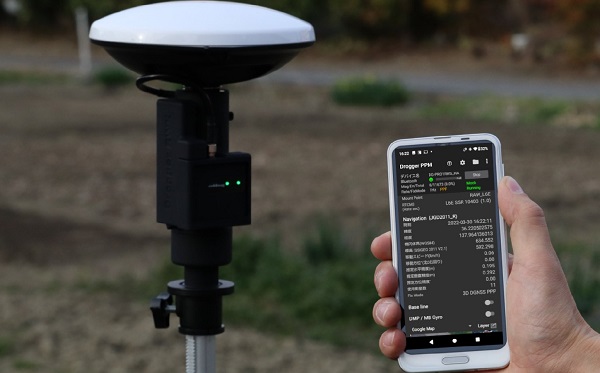
BizStation, a database company based in Japan, and u-blox have announced a highly accurate, compact and low-cost high-precision positioning solution for markets in East Asia and Oceania.
Featuring two u-blox modules, the solution delivers centimeter-level positioning accuracy where mobile network service is unavailable, including in maritime offshore surveying, agricultural and industrial vehicle guidance, and UAVs.
BizStation’s precise point positioning (PPP) system covers all territories served by Japan’s Quasi-Zenith Satellite System (QZSS) MADOCA correction service.
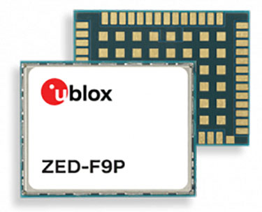
The solution leverages the strengths of two u-blox components. The first, a u-blox ZED-F9P multi-band high precision GNSS receiver module, is at the heart of BizStation’s DG-PRO1RWS GNSS receiver.
The second, a u-blox NEO-D9C correction-data receiver module specific to Japan, enables their virtual reference station to receive data on the QZSS L6E-band used by MADOCA.
The PPM (PPP positioning by MADOCA) Android application developed by BizStation then determines the location of the tracked device using the high-precision positioning data transferred via Wi-Fi from BizStation’s DG-PRO1RWS GNSS receiver as well as GNSS correction data from the virtual reference station. The PPM application performs all required calculations using the MADOCA positioning library developed by NEC Solution Innovators Co., Ltd.
The high-precision GNSS solution can be deployed either using a static or a mobile virtual reference station for a wide range of applications such as agriculture, drones, motor sports or surveying systems.
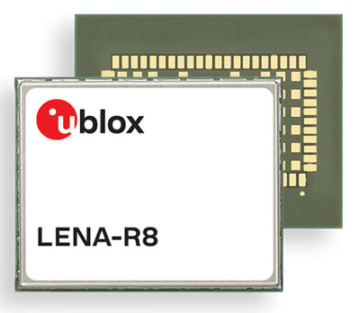
U‑blox has added a GNSS receiver module to its cellular LTE Cat 1 portfolio. The GNSS receiver in the LENA-R8 is based on the u‑blox M10 platform.
U-blox also introduced the LARA-R6, its smallest LTE Cat 1 module with global coverage. Together, the modules comprise five certified global, multi-regional and regional product variants, simplifying logistics for product developers and increasing design flexibility.
Both modules offer device makers facing imminent 2G and 3G network sunsets a future-proof migration path to 4G technology for data-streaming applications.
Additionally, they offer MQTT Anywhere and MQTT Flex connectivity via u‑blox’s Thingstream platform out of the box, thereby enabling low-power, low-cost connectivity with globally ubiquitous, seamless roaming.
Tracking and Telematics
The LENA-R8 standard-grade module series targets customers in the tracking and telematics markets seeking to minimize costs associated to their bill of material and data charges. The compact module balances cost and performance with single Rx antenna and primarily targets customer deployments in the Europe, Middle East, Africa, Asia, and South America regions.
The LENA-R8 supports a broad range of frequency bands with 2G fallback, providing maximum roaming coverage for global tracking applications using a single stock keeping unit (SKU).
A variant of the LENA-R8 series comes with an ultra-low power u‑blox M10 GNSS receiver for high performance asset tracking applications, reducing integration effort and time to market. Making no compromises in terms of GNSS performance, the module can concurrently receive up to four GNSS constellations for maximum position availability.
CellLocate Support
All variants of the LARA-R6 and LENA-R8 family support CellLocate, u‑blox’s cellular network-based location service, for coarse positioning data even in the absence of GNSS signals.
Engineering samples will be available in February.
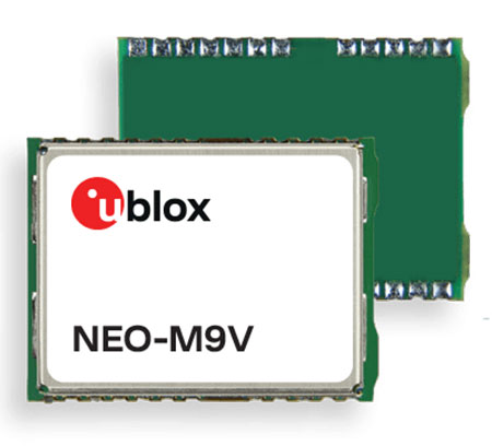
U‑blox has announced the NEO-M9V module, its first GNSS positioning receiver to offer both untethered dead reckoning (UDR) and automotive dead reckoning (ADR).
The NEO-M9V is suitable for fleet management and micro-mobility applications that require reliable meter-level positioning accuracy even in challenging GNSS signal environments such as urban canyons.
Using inertial sensor measurements, UDR offers a smooth navigation experience in dense urban environments by bridging gaps in GNSS signal coverage and mitigating the impact of multipath effects caused by GNSS signals that bounce off buildings. ADR further increases positioning accuracy in demanding environments by including the vehicle speed in the sensor-fusion algorithm.
Offering both UDR and ADR on the same module delivers maximum positioning performance and design flexibility, u-blox said. The NEO-M9V also features dynamic models optimized for both cars and e-scooters.
NEO-M9V is based on the u‑blox M9 GNSS technology platform. Its ability to track up to four GNSS constellations maximizes the number of GNSS satellites within its line of sight at any given moment. Integrated SAW and low-noise amplifier filters offer excellent interference mitigation for a robust solution. Compatibility with the NEO form factor reduces migration efforts for customers upgrading existing designs.
From its very first issues, 31 years ago, this magazine has covered the role of GPS, now GNSS, in guiding ships, trains and automobiles. What were then some of the most aspirational visions of future applications are now routine. For all forms of transportation, navigation is a safety-critical issue. This is particularly true in the case of cars on public roads, which is also where the technical challenges are the greatest. Ships mostly travel in deep waters, far away from other traffic and fixed obstructions, and nearly always enjoy an unobstructed line-of-sight to GNSS satellites. So do trains, which have the additional advantages of being kept, literally, on track and of operating in controlled environments, with hardly any concerns for unexpected intrusions on their path. Cars, trucks, and busses, on the other hand, must contend with many other vehicles, including those with distracted, drowsy, drunk, or drugged drivers, as well as cyclists, pedestrians, accidents, construction and a bedeviling myriad of sudden and often unpredictable circumstances. Additionally, their view of the sky is often limited by overpasses, tunnels and tall buildings, which challenge GNSS-based navigation with signal occultation and multipath, and their view of their surroundings is often blurred by weather conditions.
Currently, prototype autonomous vehicles carry cameras, lidar scanners, radars and ultrasonic sensors to provide positioning relative to mapped features, as well as for collision avoidance. However, some use cases require absolute positioning sensors, consisting of GNSS receivers coupled with inertial sensors. For example, autonomy levels 3 and 4 require dynamic error bounds of no more than a few meters most of the time under challenging highway conditions and levels 4 and 5 will require this level of accuracy even in deep urban canyons.
This month’s cover story highlights progress in several transportation-related GNSS/PNT applications
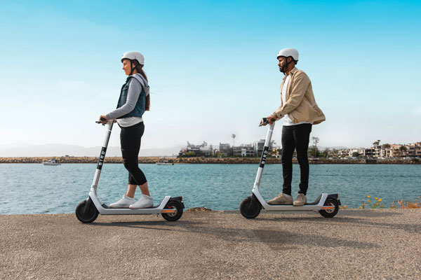
Swiss company u-blox designs and manufactures GNSS receivers used in the automotive market, including driverless cars, and for micro-mobility devices, such as the Bird scooter.
In deep urban canyons, the biggest challenge for positioning cars is achieving sufficient accuracy despite multipath, said Aravinthan Athmanathan, product manager for the company’s Automotive GNSS line of receivers. “The challenge for autonomous driving is reliable lane-accurate positioning and integrity.”
The company develops its own dead-reckoning algorithms, which use data from an inertial measurement unit (IMU) and wheel speed sensors. “We also provide dual output, so the end customer can choose whether to use GNSS only or a sensor-fused solution,” said Athmanathan. This is especially challenging at the sub-meter accuracy level.
Different Uses, Different Sensors
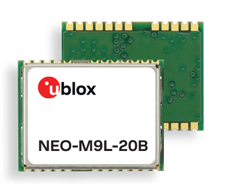
Different automotive use cases require different GNSS receivers. To meet this challenge, u-blox offers the NEO-M9L for standard precision and the ZED-F9K for high precision, depending on the customer’s needs. Additionally, it is investing a lot “in functionally safe GNSS and in being the GNSS enabler for car manufacturers,” said Karin Steinhauser, the company’s senior marketing communications manager.
For navigation with meter-level accuracy, the NEO-M9L is integrated with dead-reckoning technology and sensor fusion, using algorithms that process sensor data from the IMU and from wheel-speed sensors. It can provide reliable location data in challenging environments, such as urban canyons, where multipath becomes an issue, or tunnels, where GNSS signals are partially or totally denied, Steinhauser said. Additionally, the NEO-M9L can operate in temperatures of up to 105° C, making it suitable for integration on the roof, behind the windscreen, or inside hot electronic control units. The NEO-M9L addresses the use cases in urban environments for both navigation and systems, such as Europe’s eCall, that provide an automated message to emergency services following a road crash, including the precise location of the accident.
The ZED-F9K, on the other hand, is well suited for use cases at the higher levels of advanced driver assist systems (ADAS) defined by the Society of Automotive Engineers (SAE), which require decimeter-level accuracy. “At L3 and above, you need correction services with integrity to allow for trustworthy and reliable GNSS positioning,” Steinhauser said. “We have partnerships with Bosch on projects to develop functionally safe GNSS solutions based on a ISO26262-certified version of u-blox generation 9 GNSS technology.” The ZED-F9K is a multi-band receiver that uses GPS signals on L1-L2 and Galileo signals on E5b. “We also have a special set of features adequate for the ADAS and the autonomous driving features,” Athmanathan said.
Image: 3alexd/E+/Getty Images
Bottlenecks
One of the factors limiting how quickly u-blox can roll out solutions based on the ISO 26262 standard (titled “Road vehicles – Functional safety”) is that highly autonomous systems require more integration work by the customers, said Alex Ngi, the company’s product manager for High Precision GNSS. “The first systems are now available.” Another hurdle, he pointed out, is the legal framework for deploying autonomous driving systems. “The regulations about how things need to be tested, and the liabilities for when systems fail, affect how quickly these systems can get adopted.”
GNSS can be used as a complementary technology to enable absolute positioning for systems that fuse data streams from cameras and lidars, such as those used for ADAS level 2 applications. “Fusing all this is computationally intensive and requires high processing power, such as NVIDIA GPUs, which tend to be very hot systems. We see a lot of requirements for very high-temperature GNSS receivers, because our receivers are often co-located with these hot systems.”
Of course, u-blox does not simply hand its modules to Bosch and car manufacturers and say, “You take it from here.” Design and integration is an iterative process. “We bring in the GNSS know-how and integration support and Bosch brings in the functional safe automotive development know-how,” Ngi said.
Dead Reckoning and Map Matching
For the automotive market, u-blox has more than 20 years of experience with dead reckoning. “The sensor-fusion solution receives data from both the GNSS and the IMU, and we provide the complete final solution,” Athmanathan explained.
The system also aids the receiver by providing it external map data. “If you’re driving your car northbound and the GNSS receiver tells you that it’s headed in the opposite direction, or that you’ve jumped over to the lane to the other side of the highway, clearly that cannot be right,” Ngi said. “Map matching relies on simple messages that come into our receivers to give us positive feedback on our measurements.”
For non-automotive applications, u-blox makes the ZED-F9R. It is used, for example, in robotic lawnmowers, very common in Asia and Europe, which require centimeter-level accuracies. “That’s why it focuses on delivering corrections using SPARTN, which can be a continent-wide data stream,” Ngi said. “We also make the design so that it’s very easy to integrate and enables the designers to easily pass the corrections to their receivers fully encrypted. This way, the value of the data is delivered to the lawnmower without exposing it to the system designer, so that we don’t need to go check every design to see whether somebody is leaking secured correction services.”
By the end of November, according to u-blox, updates of the ZED-F9P multi-band GNSS receiver will include decryption of the SPARTN correction data and a 95-percentile protection level. The protection level increases the trust non-safety-critical applications can place in its position output. By continuously outputting the upper bound of the maximum likely positioning error, referred to as the protection level, the receiver lets autonomous applications, such as UAVs or robotic lawnmowers, make efficient real time path planning, increasing the quality of their operations.
Guiding eScooters and EVs
In some places, Ngi pointed out, e-scooters are required to use a bike lane, which might be only two or three feet wide and may not be along the side of a building as it would be on a sidewalk. “The ZED-F9R is a much more flexible solution than camera systems that only know sidewalks or bike lanes.” Bird uses it to throttle driving speeds to match speed limits, which change from one location to another. “It is also much more scalable for them as opposed to such solutions as using UWB [ultra-wideband] beacons to fence off different areas, which are not really scalable for a company that wants to deploy solutions to hundreds of cities.”
Xpeng Motors, a manufacturer of smart electric vehicles, uses u-blox F9 GNSS receivers, which use signals from all four GNSS constellations, in its P7 super-long-range sports electric vehicle sedan. The vehicle uses ADAS for navigation-guided driving, automated parking and autonomous driving. For instance, once a navigation destination is set on a specific highway, the P7 will follow the route guidance to execute autonomous lane changing, switch to high-speed routes, and select the optimal route in real-time.
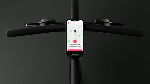
Scooter company Bird and u-blox have jointly developed a new Smart Sidewalk Protection system to help prevent shared scooters from operating on city sidewalks. It uses the u-blox ZED-F9R, a dead-reckoning module that fuses GNSS and sensor data, delivering centimeter-level location information in any condition. This allows the system to monitor whether a Bird e-scooter is being operated unsafely, such as on a sidewalk or speeding. Using Bird data, the companies co-developed a version of the ZED F9R module tailored to meet the needs of the shared micromobility industry.
The dual-band ZED-F9R GNSS receiver supports up to eight times more satellite signal types and four times more constellations (GPS, Galileo, GLONASS and BeiDou) than typical solutions. The module processes real-time vehicle data, including wheel speed, IMU sensor data (including acceleration and heading), and real-time kinematic data that corrects for ionospheric interference. The technology is also optimized for e-scooters by applying dynamic models matching their movements.
To turn this sensor-fusion module into its Smart Sidewalk Protection system, Bird developed a five-step process for creating sidewalk maps with centimeter accuracy. It starts with a geofence outline constructed from satellite imagery or city GIS data. Bird then uses surveying equipment to measure the location of three city landmarks. Only a few measurements are needed for each city. Once the landmarks have been identified, they compare their location to the satellite imagery to determine offsets and rotations and use them to shift and transform each of the original geofence outlines. Finally, they pre-load the updated geofence outlines onto Bird vehicles to eliminate latency. When combined with the hyper-accurate location measurements provided by Bird’s sensor-fusion module, they can detect and respond to sidewalk riding almost instantly, according to Bird.
The micromobility module is being piloted in Milwaukee and San Diego. Madrid will be Bird’s first pilot city in Europe, with plans for a broader roll-out slated in 2022.
GNSS correction service receivers and the firmware-upgraded ZED-F9P upgraded to achieve reliable centimeter-level accuracies in seconds
Photo: U-blox
U‑blox is offering a suite of products and feature additions that simplify access to reliable centimeter-level positioning accuracies for the industrial, navigation and robotics markets.
The upgraded ZED-F9P high-precision GNSS receiver module and the corresponding NEO-D9S and NEO-D9C GNSS correction data receivers offer customers flexibility in assembling scalable solutions for their specific use cases, including robotic lawnmowers, unmanned autonomous vehicles (UAV) and semi-automated or fully automated machinery.
The software-upgraded u‑blox ZED-F9P-04B high-precision GNSS receiver is the first to support a secure SPARTN GNSS correction data format. It seamlessly connects to two new GNSS correction service receiver modules that stream correction data from communication satellites:
The u‑blox NEO-D9S will initially cover the European and U.S. markets before rolling out to the other areas of the globe.
The u‑blox NEO-D9C will cover Japan.
The NEO-D9S receives correction data using the SSR SPARTN data format over the satellite L-band channel. It uses cryptography to securely deliver PPP-RTK GNSS correction data, such as that offered by u‑blox’s PointPerfect service.
The NEO-D9C leverages the subscription-free Centimeter-Level Augmentation Service (CLAS) broadcast over mainland Japan provided by the Japanese Quasi-Zenith Satellite System (QZSS) constellation on the L6-band channel.
While u‑blox GNSS receivers are designed to work with most correction services on the market, pairing the ZED-F9P with the NEO-D9C or the NEO-D9S correction data receiver enables customers to save data transmission cost and operational efforts, the company said.
ZED-F9P-04B offers a new feature called protection level, which increases the trust applications can place in its position output. By continuously outputting the upper bound of the maximum likely positioning error, referred to as the protection level, the receiver lets autonomous applications, such as UAVs, make efficient real time path planning, increasing the quality of their operations.
In the case of robotic lawnmowers, the increased accuracy and reliability of the position will, for example, make it possible to do away with boundary wires, which today are buried under the turf to delimit the mowing area. Furthermore, it will allow lawnmowers to systematically cover a plot based on a digital map, as opposed to the random mowing approach commonly used today.
First samples of these products are available today, in professional and automotive grade. The correction data receivers will be available in automotive grade for the automotive markets.
SoftBank Corp., ALES Corp. and u-blox AG have signed a memorandum of understanding to cooperate in GNSS augmentation services for global markets.
SoftBank provides the “ichimill” GNSS augmentation service in Japan, its subsidiary ALES operates a business that generates and delivers positioning correction data, and u-blox is a global provider of positioning services for the automotive, industrial and consumer markets.
U-blox also provides electronic components for wireless communications and the PointPerfect GNSS augmentation service in Europe, the United States and other countries and regions.
Through this business collaboration, SoftBank, ALES and u-blox will construct GNSS augmentation infrastructure for Japan, Europe and the United States, develop GNSS receivers and devices, and expand service areas.
Collaboration Background
Since November 2019, SoftBank has been offering ichimill, a GNSS augmentation service that offers highly accurate positioning with a margin of error of a few centimeters in the Japan market. In addition to providing technology that enables the generation and delivery of correction data, ALES has been offering a centimeter-level positioning service to consumers in Japan since August 2020.
In July 2021, u-blox began providing PointPerfect, a PPP-RTK-based GNSS augmentation service, which is now available in the contiguous United States and Europe.
GNSS augmentation services like these are mainly offered separately by country and region. Client companies, which include global automotive manufacturers and agricultural machinery manufacturers, sign up for separate service contracts in each country and region, making GNSS receiver configuration more complex.
Collaboration Overview
To offer global GNSS augmentation services, SoftBank, ALES and u-blox will study the following initiatives.
Develop a global correction data delivery infrastructure. GNSS augmentation services use correction methods that differ by country and region, and there is a wide variety of correction signal formats. In 2022, the three companies will consider developing a correction data delivery infrastructure that delivers unified correction signal formats for use in any country or region. With this infrastructure, companies using ichimill or PointPerfect will be able to conduct GNSS augmentation if they are in range of both services, which will eliminate the need for separate service contracts by country or region.
Jointly develop global-compatible devices. In addition to correction data delivery, an environment that allows for the easy implementation of GNSS receivers and other devices is necessary for GNSS augmentation services. In conjunction with the launch of ichimill, SoftBank developed its own GNSS receivers and is offering them in Japan. The three companies will consider jointly developing GNSS receivers and modules that can be used globally.
Greater GNSS augmentation accuracy and service area expansion. The companies will collaborate closely to ensure that the performance of the services in all the regions covered are comparable. This is important to provide a consistent customer experience across all regions. Furthermore, the three companies plan to study service expansion into other areas, including Asia. SoftBank is promoting the deployment of non-terrestrial network (NTN) solutions that encompass satellite- and stratospheric-based telecommunication platforms to provide connectivity to the sea, the sky, developing countries and rural areas lacking internet infrastructure so everyone around the world has access to the internet. The three companies will consider the development of NTN-linked services, such as correction data delivery using small amounts of data in a way that is suitable for NTN bandwidths.
The Cowboy e-bike solution provides riders with high-performance, real-time GNSS accuracy, enabling them to map their own paths and those of the cities they live in.
The Cowboy e-bike uses smart road-companion applications to ensure riders get precise information, regardless of the route they travel. The positioning component uses Taoglas’ Accura GVLB258.A, a multi-band GNSS L1/L5, high-performance stacked patch antenna, in conjunction with u-blox’s SAM-M8Q GNSS positioning module. The combination allows for extremely low power and high accuracy.
The solutions works with “micromobility” services offered by Cowboy, such as Easy Rider for theft detection, bike insurance, and crash detection notifications.
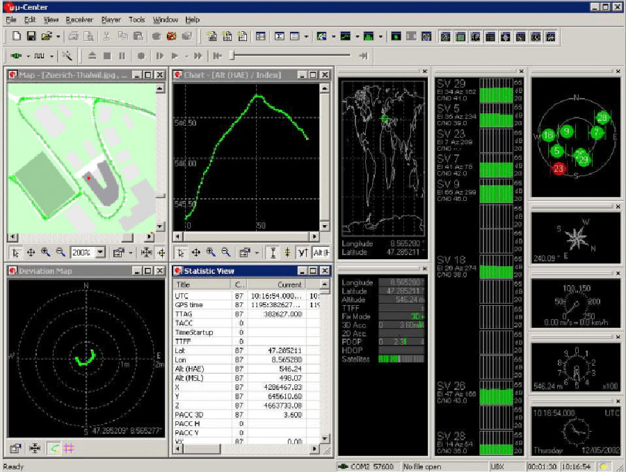
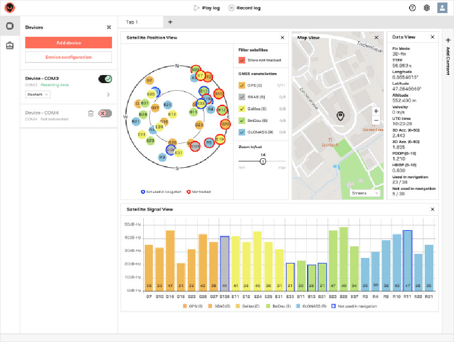
U‑blox has launched its new GNSS evaluation software, u-center 2. The software, which runs on Microsoft Windows, offers anyone working with 10th-generation (M10) u‑blox GNSS technology a highly intuitive interface to configure GNSS products, evaluate their performance, improve the quality of their software, and experience the performance boost achieved using GNSS-related services.
U-center 2 is the successor to the u-center GNSS evaluation software, which has been used by design engineers for almost two decades to develop GNSS receiver applications. Compatible with u‑blox M10 GNSS technology, u-center 2 is designed to offer improved performance over its predecessor, as well as new features that simplify configuration, evaluation and software development of GNSS-based solutions.
Screenshot: U-blox
U-center 2 provides personalized workspaces with adaptive window elements offering a choice of views to observe static and dynamic behavior of the connected GNSS receiver. The built-in log player, which accepts log files from the previous version of the software, features easy message- and time-based navigation and lets users set the playback speed, making development of end products more efficient. Automatic updates ensure that the software includes the latest features with minimal user effort.
U-center 2 simplifies the evaluation of GNSS-related location services such as AssistNow, through which GNSS receivers gain access to GNSS aiding data, enhancing startup performance, and saving power.
Predecessor u‑center will continue to be the go-to solution for GNSS solutions based on earlier technology platforms.
“We are confident that users will immediately recognize how easy u-center 2 makes it to set up and evaluate the latest generations of our GNSS chips and modules,” said Bernd Heidtmann, product manager, Product Strategy for Standard Precision GNSS, u‑blox. “With its fresh and minimalist user interface, the upcoming quick product configuration designed for key use cases, and optimized data logging, u-center 2 will raise the benchmark for GNSS evaluation tools in terms of performance and user experience.”
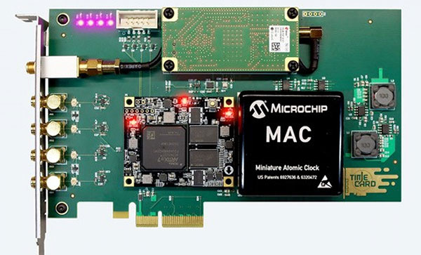
Facebook has open-sourced the design of its time card, which features the ultra-precise u‑blox ZED-F9T timing module, providing easy access to nanosecond-level timing
Photo: u-blox
Facebook has chosen the u‑bloxZED-F9T GNSS receiver module for timekeeping, according to u-blox. By improving the synchronization of networked computers, Facebook’s time card can significantly speed up the performance of its data centers and distributed databases.
By open-sourcing their designs, Facebook has bolstered the adoption of highly accurate timing solutions based on u‑blox technology. These solutions can be adopted by other industries requiring nanosecond-level timing, such as 5G cellular networks or smart power grids.
Facebook set out to create a precise timing solution that reduces the computational overhead required when synchronizing the timing between different computers in a network, u-blox said. The social media company used a u‑blox ZED-F9T multi-band GNSS receiver to sync up its solution with the highly accurate GNSS atomic clocks. To bridge possible gaps in GNSS coverage and keep clock drift to a minimum, the time card contains a backup timing source: a miniaturized atomic clock continuously synchronized with GNSS time.
To maximize the impact of the solution, Facebook decided to open-source the design of its time card, which fits onto a PCIe form factor. Anyone with experience working with microelectronics can turn any PC built on an x86 architecture and featuring a network interface controller into a nanosecond-level-accurate timing and synchronization solution, u-blox said.
Easy access to nanosecond-level timing accuracy — based on the u‑blox RCB-F9T timing board, which hosts the u‑blox ZED-F9T GNSS receiver — opens new avenues in industry segments that rely on highly synchronized signals, such as 5G network base stations that require tighter synchronization than those of previous generations, u-blox said.
As power-distribution networks become more complex to accommodate a growing share of decentralized renewable energy, they are becoming more reliant on reliable and accurate timing solutions. Data centers and computer networks will be able to modernize infrastructure management to speed up performance and reduce latencies.
Facebook has shared the GitHub repository including the specs, the schematics, the mechanics, the bill of material, and the source code in partnership with the Open Compute Project (OCP) under the Time Appliance Project (TAP).
Continuous accurate navigation in all environments with sensor-based spoofing detection
Photo: U-blox
U-blox is introducing a series of automotive-grade positioning modules that are operational up to 105° C (221° F). The NEO-M9L modules and the M9140-KA-DR chip are built on the robust u-blox M9 GNSS platform and use dead-reckoning techniques to provide accurate position data when satellite signals are compromised or unavailable.
The u-blox NEO-M9L-20A and NEO-M9L-01A modules, as well as the M9140-KA-DR chip, are specially designed for first-mount automotive solutions. The modules and the chip are all automotive-grade, with the NEO-M9L-01A variant offering an extended operational temperature range up to 105 °C, making it suitable for integration on the roof, behind the windscreen, or inside hot electronics control units.
Applications include integrated navigation systems such as in-vehicle infotainment (IVI) and head units, integrated telematics control units and V2X.
The modules include new-generation 6-axis inertial measurement units (IMUs) that deliver low-latency 100-Hz RAW data output. The modules offer a low-latency 50-Hz position update rate, making it suitable for use in real-time applications. The automotive dead-reckoning (ADR) output combines the GNSS fix with IMU data to deliver accurate positioning output for various scenarios.
Additional GNSS-only output enables seamless integration into a variety of third-party applications. The receiver also supports wake-on-motion, which enables smart features such as theft protection and power-efficient designs.
The modules offer innovative sensor-based spoofing detection for advanced security and robustness. The chip offers protection against possible GNSS signal spoofing, which can cause navigation systems to report faulty position data or time.
“The u-blox M9 sensor-fusion products address the latest automotive market demands for quality, reliability and robustness. Availability and trustworthiness of position output are increased by using concurrent reception of four GNSS constellations,” said Aravinthan Athmanathan, product manager, Product Center Positioning at u-blox. “In addition, the spoofing-detection feature is brought to a new level compared to the predecessor. Paired with low-latency position output, attitude, and sensor data, the u-blox NEO-M9L is ready to meet current and future challenges facing the automotive market.”
All the module variants are compliant with AEC-Q104, the latest standard for ensuring the reliability of modules used in automotive applications. Engineering samples and evaluation kits will be available by the end of September.