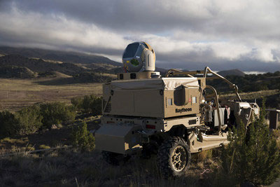
According to Raytheon, its HELWS uses energy to detect, identify, track and take down drones. (Photo: Raytheon)
Raytheon Company will deploy two prototype high-energy laser weapon systems (HELWS) to troops overseas under a $24 million U.S. Air Force contract. The U.S. Air Force’s experimentation includes 12 months of in-field operation against unmanned aerial systems and operator training.
Raytheon’s HELWS uses energy to detect, identify, track and take down drones. According to the company, the system can target a single drone with precision. The HELWS is paired with Raytheon’s Raytheon’s Multi-spectral Targeting System. Raytheon’s HELWS, which comes mounted on a Polaris MRZR all-terrain vehicle, uses invisible beams of light to defeat hostile unmanned aerial systems.
“Every day, there’s another story about a rogue drone incident,” said Stefan Baur, vice president of Raytheon Electronic Warfare Systems. “These threats aren’t going away, and in many instances, shooting them with a high energy laser weapon system is the most effective and safest way to bring them down.”
Raytheon, headquartered in Waltham, Massachusetts, is a technology and innovation company that specializes in defense, civil government and cybersecurity solutions.
Ensuring the freedom to continue innovating is vital to our global economy, job creation and ultimately to empowering the next generation of GPS-enabled applications.
GPS — it’s a household name and has come to benefit so many aspects of our day-to-day lives. Today across the globe, it is estimated that there are more than 3 billion GPS receivers in the marketplace. Included in this total are GPS receivers found in mobile phones, automobiles, airplanes, tractors, boats and high-precision surveying equipment, to name just a few examples. In the past decade alone, GPS applications like these have helped generate more than $1.2 trillion for the U.S. economy and millions of jobs.
So how did GPS become so ubiquitous? Thanks to the leadership of the United States Air Force, which maintains and operates the GPS constellation, and long-standing U.S. policy, which makes GPS available as a vital public resource, any private sector company can design and build a receiver capable of listening for these GPS signals, without seeking the government’s approval or paying user fees. This freedom to innovate is at the heart of why GPS has been so successful and continues to drive innovation across our economy.
With the freedom to innovate, GPS receiver manufacturers have developed a range of advanced technologies to address market needs from the simple to the highly complex. These technologies reflect the inherent functional and technical differences between radio communications services and a navigation service like GPS.
Huge range of technologies. GPS receiver innovations enable a receiver to listen for a GPS signal that is less than a millionth of a billionth of a watt, while simultaneously resisting interference that is 10,000 times greater. Whether the GPS receiver is found in a tiny smartwatch or a 20-ton tractor, what they have in common is the ability to convert a faint radio signal into what we most commonly recognize as our current location displayed as a blue dot. They do this remarkably well.
Today’s regulatory landscape also correctly recognizes that every GPS-enabled application has unique requirements driven by intended function, environment and design factors. For example, a GPS receiver used for synchronizing financial transactions has different demands from a GPS receiver found in an autonomous vehicle. The former focuses on timing while the latter needs precise positioning to help maintain lane-level guidance.
Similarly, high-precision surveying equipment capable of delivering centimeter-level accuracy will no doubt have different receiver and antenna requirements than those found in a typical smartphone. The freedom to innovate enables GPS receiver manufacturers to support this market differentiation.
GPS resiliency. With many of our nation’s key critical infrastructure sectors dependent on GPS, there has been increasing discussion in Washington about the resiliency of GPS. Some have specifically expressed concern that a GPS jamming or spoofing attack could disrupt these key services and have advocated for new requirements on GPS receivers.
To be clear, GPS jammers and spoofers are illegal devices, designed specifically to interfere with GPS signals, either blocking the signal outright or emitting a fake signal in order to falsify one’s location. In either scenario, this interference occurs within a localized area from a detectable source. So, the reality is that mandates won’t stop a malicious actor intent on illegally interfering with GPS or another wireless technology, but vigorous enforcement of U.S. federal law can.
It is also important to remember that the GPS satellites are a multi-use U.S. military-civilian asset, supporting the mission of our armed forces, and have therefore been built with the highest levels of security and redundancy. Any attempts to attack the GPS constellation risks impacting not just civil services but the military signal as well.
Mission-critical applications. When it comes to resiliency, open innovation enables GPS receiver manufacturers to work with mission-critical application providers to develop products designed to meet their specific requirements. Different categories of users can and should define and specify performance and resiliency requirements appropriate for their applications.
For example, the requirements for a military GPS receiver are much more demanding than those for the receiver in an IoT device that reports its position hourly or daily. A military GPS receiver will, therefore, be significantly more expensive than an IoT receiver. Conversely, those who deploy internet of things (IoT) receivers will require low price points to support ubiquitous applications.
GPS manufacturers and applications developers have responded to market requirements by providing new and innovative techniques for increasing resilience, including designing receivers capable of receiving signals from multiple GNSS systems. This is the best way to ensure resilience — via application-specific requirements that are driven by customers who are most knowledgeable about their needs, not by general regulations or government fiat.
Preserving signal access. At the same time, the government does have a responsibility to investigate and take the necessary enforcement action to preserve unhindered reception of GPS signals. Vigorous enforcement of federal law by the Federal Communications Commission (FCC) and other government agencies — which already prohibits the manufacture, importation, marketing, sale and operation of GPS jammers — can keep these illegal devices out of the hands of those seeking to disrupt GPS operations. Such enforcement is critical to protecting our military operations, aviation and other safety-of-life applications.
Over the past three decades, worldwide adoption of robust, innovative GPS receivers attests to the trust users have placed in GPS as the gold standard for availability, accuracy, reliability and resiliency. Ensuring the freedom to continue innovating is vital to our global economy, job creation and ultimately to empowering the next generation of GPS-enabled applications.
About the GPS Innovation Alliance
The GPS Innovation Alliance was founded by Deere & Company, Garmin International Inc. and Trimble Inc. The Alliance recognizes the ever-increasing importance of GPS and other GNSS technologies to the global economy and infrastructure and is firmly committed to furthering GPS innovation, creativity and entrepreneurship. The GPS Innovation Alliance seeks to protect, promote and enhance the use of GPS. For more information, visit www.gpsalliance.org or follow @GPS4Life.
J. David Grossman serves as executive director of the GPS Innovation Alliance (GPSIA), an organization dedicated to protecting, promoting and enhancing the use of GPS. Prior to joining GPSIA, Grossman spent nearly a decade in public service, including as chief of staff to FCC Commissioner Mignon Clyburn; legislative director and senior advisor for technology policy to Rep. Anna Eshoo of Silicon Valley; and as technology counsel to the U.S. House Small Business Committee under the leadership of Rep. Nydia Velázquez.
Grossman holds a Master’s Degree in Public Policy from George Mason University and a B.A. in Political Communication from George Washington University’s School of Media and Public Affairs.
With tariffs, trade wars and sanctions ruling the day, how is a self-respecting UAS manufacturer supposed to make a buck? And to whom are the manufacturers of defense UAS able to sell their wares?
To NATO and other friendly countries, comes the ready answer, but there may still be a problem selling drones with armaments and offensive capabilities. Another layer of governmental review could swing into action when a company wants to sell to friendly countries like Saudi Arabia or perhaps to allies within the old Russian USSR block.
Last year, General Atomics lost sales to Saudi Arabia and the United Arab Emirates (UAE) for Predators and/or Reapers, large-bodied medium-altitude, long-endurance unmanned aircraft systems (or MALES). The deal went instead to a competing Chinese outfit. General Atomics complained bitterly about the loss of this business, which it blamed on restrictive U.S. export rules. The Administration responded by apparently loosening the regulations, in fact easing the way for most international sales. In response, it is possible that UAV manufacturers have also undertaken some changes which make U.S. drones even more competitive for export.
Business matters appear to have improved significantly. In May this year, the State Department actually used emergency provisions within the Arms Control Act to bypass Congressional review of a proposed sale to Saudi Arabia, UAE and Jordan of a package of Insitu Blackjack drones and launchers, worth $80 million.
The competition for world-wide sales of U.S. UAS products is increasingly tough, especially against Chinese suppliers with equivalent or perhaps less capable mil-spec drones. Hence the export rule changes which now appear to be working in the right direction.
Chinese Drones in the U.S.
Meanwhile, in an effort to accommodate U.S. concerns about the potential for user data somehow “leaking” to DJI — the Chinese supplier of almost 75% of U.S. drone purchases — DJI has implemented a “Government Edition” which apparently addresses the risk of data loss.
When US-based 3D Robotics stopped supplying 3DR Solo drones, the Interior Department found itself in a bind, as it had already bought hundreds of these devices for its inspection/surveillance operations. As the department searched for a new source for UAVs, it came to the conclusion that U.S. supplied drones were much less capable or up to ten times more expensive than equivalent DJI units. So they began working with DJI to solve the issue with potential data loss, and went on to test the results extensively
Working with the U.S. Interior Department for over 18 months, DJI has equipped drones and their controllers with modified hardware and custom software that ensure that the drones only operate in local data mode: information collected in flight is stored on the UAV alone and must be manually downloaded after flight. The drone is actually loaded with custom software by the user prior to flight to ensure this mode of data collection.
Even with these modifications, for now the use of DJI drones is still restricted to non-sensitive applications.
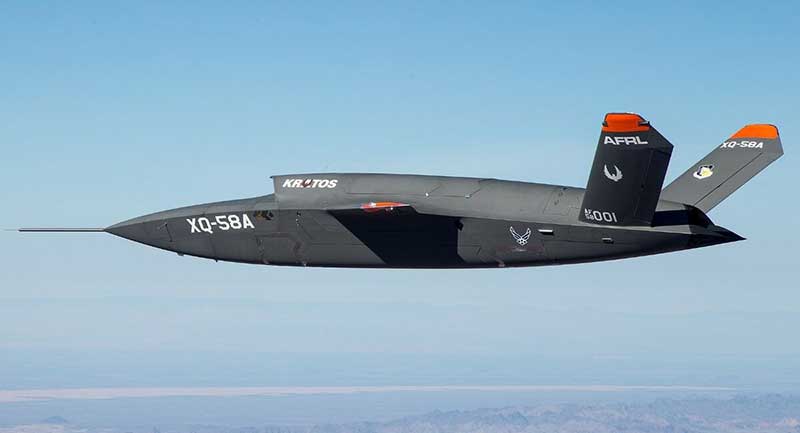
USAF/Kratos XQ-58A
The XQ-58A Valkyrie demonstrator, a long-range, high subsonic UAV completed its inaugural flight March 5, 2019, at Yuma Proving Grounds, Arizona. (Photo: U.S. Defense Department)
Kratos is working with the U.S. Air Force to develop a jet-powered UAV system that can fly alongside manned fighter aircraft to multiply their effectiveness. At much lower cost than manned aircraft, the concept appears to be that more risk can be taken with the ‘loyal wingman’ UAVs to not only support the mission of the attack aircraft, but to also keep it safe.
We reported earlier on the XQ-58A after its first flight in March of this year. Now the Valkyrie is back in the flight test program with its second flight lasting 71 minutes over the Yuma test range on June 11. In the long- erm, it is hoped that both ground controllers and flight crew would operate these extensively autonomous drones.
A parallel “Skyborg” program is also underway to develop the hardware and artificial intelligence software capability to enable this type of drone to fly and fight alongside manned aircraft.
In conclusion, trade wars and tariffs aside, let’s hope that good UAV products can still make headway on their merits alone.
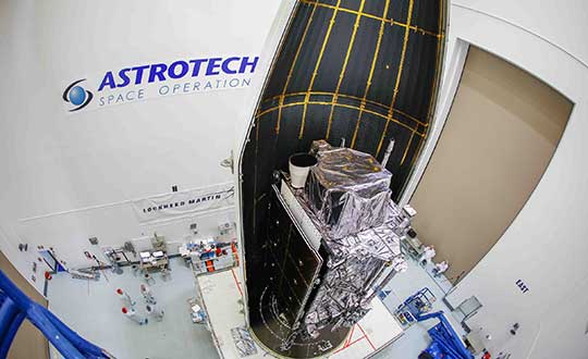
The second next-generation GPS III satellite — nicknamed “Magellan” by the U.S. Air Force — is encapsulated and ready for its planned July 25 launch.
On June 26, Lockheed Martin Space and United Launch Alliance (ULA) technicians completed encapsulating GPS III Space Vehicle 02 (GPS III SV02) in its launch fairings at the company’s Astrotech Space Operations facility, where the satellite has undergone pre-launch processing and fueling since its March 19 arrival in Florida. This final step enclosed GPS III SV02 in a protective, aerodynamic, nose-cone shell.
In the coming days, the enclosed GPS III SV02 satellite will be mounted to a ULA Delta IV rocket for launch. The current window for launch on July 25 opens at 10:55 a.m. ET.
“GPS III SV02 is launching just a brisk seven months after the nation’s first GPS III satellite lifted off back in December. The first satellite’s performance during on-orbit testing has exceeded expectations,” said Johnathon Caldwell, Lockheed Martin’s vice president for Navigation Systems. “We are excited to deploy more GPS III satellites so this new technology and capabilities can be distributed constellation-wide.”
GPS III satellite production and launch cadence is picking up. On May 27, the Air Force declared the next GPS III satellite, GPS III SV03, available for launch, pending an official launch date.
“More GPS III satellites are coming. If you looked at our production line back in Denver today you would see GPS III space vehicles 04, 05 and 06 already fully-assembled and in various stages of testing. And space vehicles 07 and 08 are being built up at the component assembly level now,” Caldwell added. “It is a smooth, efficient, methodical process.”
Lockheed Martin is under contract to develop and build up to 32 GPS III/IIIF satellites for the Air Force. GPS III will deliver three times better accuracy and provide up to eight times improved anti-jamming capabilities. GPS III’s new L1C civil signal will make it the first GPS satellite to be interoperable with other international global navigation satellite systems, like Galileo.
Additional GPS IIIF capabilities will begin being added with the 11th satellite. These will include a fully-digital navigation payload, a Regional Military Protection capability, an accuracy-enhancing laser retroreflector array, and a search-and-rescue payload.
Raytheon Company‘s advanced high-power microwave and mobile high-energy laser systems engaged and defeated multiple unmanned aerial system targets during a U.S. Air Force demonstration. The mature HPM and HEL technologies offer an affordable solution to the growing UAS threat, the company said.
Raytheon made the announcement at AUVSI Xponential, taking place this week in Chicago.
Raytheon’s mobile high energy laser looks out into a wide-open sky. The company’s advanced high-power microwave and high-energy laser engaged and defeated dozens of unmanned aerial system targets in a recent U.S. Air Force demonstration.
The HEL system, paired with Raytheon’s Multi-Spectral Targeting System, uses invisible beams of light to defeat hostile UASs. Mounted on a Polaris MRZR all-terrain vehicle, the system detects, identifies, tracks and engages drones.
“Countering the drone threat requires diverse solutions,” said Stefan Baur, Raytheon Electronic Warfare Systems vice president. “HEL and HPM give frontline operators options for protecting critical infrastructure, convoys and personnel.”
Raytheon’s HPM uses microwave energy to disrupt drone guidance systems. High-power microwave operators can focus the beam to target and instantly defeat drone swarms. With a consistent power supply, an HPM system can provide virtually unlimited protection.
“After decades of research and investment, we believe these advanced directed energy applications will soon be ready for the battlefield to help protect people, assets and infrastructure,” said Thomas Bussing, Raytheon Advanced Missile Systems vice president.
Raytheon’s HEL and HPM were the only directed energy systems that participated in this Air Force experimentation demonstration. The event expanded on previous directed energy demonstrations such as a U.S. Army directed energy exercise held in 2017.
Raytheon Company’s advanced high-power microwave and mobile high-energy laser systems engaged and defeated multiple unmanned aerial system targets during a U.S. Air Force demonstration. The mature HPM and HEL technologies offer an affordable solution to the growing UAS threat, the company said.
Raytheon made the announcement at AUVSI Xponential, which took place April 29-May 2 in Chicago.
Raytheon’s mobile high energy laser looks out into a wide-open sky. The company’s advanced high-power microwave and high-energy laser engaged and defeated dozens of unmanned aerial system targets in a recent U.S. Air Force demonstration.
The HEL system, paired with Raytheon’s Multi-Spectral Targeting System, uses invisible beams of light to defeat hostile UASs. Mounted on a Polaris MRZR all-terrain vehicle, the system detects, identifies, tracks and engages drones.
“Countering the drone threat requires diverse solutions,” said Stefan Baur, Raytheon Electronic Warfare Systems vice president. “HEL and HPM give frontline operators options for protecting critical infrastructure, convoys and personnel.”
Raytheon’s HPM uses microwave energy to disrupt drone guidance systems. High-power microwave operators can focus the beam to target and instantly defeat drone swarms. With a consistent power supply, an HPM system can provide virtually unlimited protection.
“After decades of research and investment, we believe these advanced directed energy applications will soon be ready for the battlefield to help protect people, assets and infrastructure,” said Thomas Bussing, Raytheon Advanced Missile Systems vice president.
Raytheon’s HEL and HPM were the only directed energy systems that participated in this Air Force experimentation demonstration. The event expanded on previous directed energy demonstrations such as a U.S. Army directed energy exercise held in 2017.
U.S. positioning, navigation and timing (PNT) capabilities are vitally important to millions of civilians, as well as U.S. and allied militaries.
The third Navigation Technology Satellite will go beyond GPS III — whose capabilities, mark you, are not yet online — to investigate new experimental antennas, flexible and secure signals, increased automation and use of commercial ground assets.
By Joe Rolli, Harris Corporation
Joe Rolli, Director of Business Development, Space and Intelligence Segment. (Photo: Harris Corporation)
Over the past decade, military leadership and national strategists have shared their concerns about U.S. dependence on GPS for everything from financial transactions to commercial transportation scheduling to precision weapon system guidance.
The new generation of Air Force GPS satellites, which began launching in late 2018, marks a significant step toward improving GPS services with three times greater accuracy and up to eight times improved anti-jamming capabilities over the previous GPS satellite block.
Now the Air Force Research Laboratory and the Space and Missile Systems Center are focusing the Department of Defense’s first experimental Navigation Technology Satellite (NTS) in more than 40 years: on initiatives that will demonstrate new tactics, techniques, and procedures to improve PNT resiliency and counter threats to GPS.
As a unique satellite that flies outside of the GPS constellation, NTS-3 will host experiments with impact across the PNT user spectrum — military, civil, academic and commercial. It will explore innovations in atomic clocks, antennas, reprogrammable digital waveform detectors, signals and other technologies.
Harris, the satellite prime contractor for NTS-3, is approaching these mission innovations from the standpoints of responsiveness and resiliency as well as technology advancement. For example, the design will support the simultaneous broadcast of dual-frequency, regional high power, and Earth coverage signals. An agile waveform platform will demonstrate the ability to rapidly develop and deploy new signal waveforms with total flexibility throughout the satellite life cycle. These innovations will allow operation in multiple contested environments, a key to achieving resiliency that can combat electronic jamming, spoofing and more.
Another strategy is the design of a modular NTS-3 payload that can be reprogrammed in space. Based on open, industry standards and interfaces, the payload will be scalable and can be hosted on diverse platforms and in varied orbits with minimal changes.
When NTS-3 launches for its planned one-year experimental campaign — anticipated to begin in 2022 — it will be the latest in a series of experimental spacecraft that have blazed the trail for the extraordinary technological advances that led to the GPS system we enjoy today
Photo: U.S. Air Force / Staff Sgt. Scott H. Spitzer
Much development has been necessary to enable the new M-code capability on more than 700 weapon systems that require it. This article overviews M-code, the updates to antenna and receiver technology to make these varied platforms M-code ready, and perspectives from key stakeholders in the M-code community.
December 23, 2018, marked an important milestone for GPS. The successful launch of satellite USA-289 represented a key success in what has been a monumentally expensive government program, beset by delays and overspends.
The launch of the first GPS Block III satellite, the first that can provide the full military M-code capability, effectively commenced the physical roll-out of modern M-code hardware.
Ground Control. As far as the space segment is concerned, M-code is finally underway. What about the ground segment? The next-generation GPS operational control system, GPS OCX, is essential for use of the full capabilities of the new Block III satellites. It has been under development for some time.
OCX has drawn Congressional criticism and correlative media attention, but recent reports have been more positive. Since the Nunn-McCurdy breach of 2016, when the project’s future hung in the balance, accounts have grown gradually optimistic. Budget and schedule were re-baselined, and contractor Raytheon’s corrective actions generated results. In the fall of 2017 the Air Force took delivery of OCX Block 0, marking a significant milestone. Block 0, also known as the Launch and Checkout System (LCS), demonstrated compliance with contractual requirements and was accepted by the Air Force.
In spring 2018, Block 0 underwent a series of cybersecurity tests and passed, validating the security architecture of the system. All this puts Raytheon on track to deliver OCX Block 1 in 2021, providing full operational capability. Block 1 and Block 2 are intended to be delivered together, adding operational control of the modernized satellites and signals, including L1C and the modernized M-code.
“There have been no schedule slips with the GPS OCX program since 2017, and the GPS III launch last December was clear proof of our progress,” stated Dave Wajsgras, president of Raytheon’s Intelligence, Information and Services business. “We will continue to meet all of our commitments, and importantly, we will meet our June 2021 contractual deadline.”
Col. Steve Whitney of the GPS Directorate wrote in this magazine in December 2018 that “The journey over the past few years has been challenging, but we have emerged stronger, armed with better metrics, and a culture of integrated development (often called DevOps) which puts us on a path to success. There will be challenges and risks in the path ahead but rather than mountains to climb, I see these more as standard blocking and tackling of a software-intensive program.”
Meanwhile. The Air Force plans to deploy M-code capability in 2020, and OCX seems unlikely to be ready. For this reason, Lockheed Martin was awarded a contract to modernize the existing ground infrastructure as a “gap filler.”
The GPS Control Segment Sustainment II (GCS II) contract was awarded on Dec. 21, 2018, and is worth $462 million. GCS II will support operational capability of M-code in 2020, and continues until 2025, and so there will be a period of overlap between GCS II and OCX, essentially providing two options for controlling the new GPS III constellation. In one view, the Air Force is backing two horses to improve chance of winning: OCX the preferred solution, with GCS II almost like an insurance policy.
With the GPS III ground and space segments looking relatively healthy, attention turns again to the user segment.
WHY M-CODE?
Until now, the military has used the classic P(Y) signal: a binary phase shift keying (BPSK)-modulated encrypted wideband signal. It offers both greater accuracy and increased jamming resistance when compared to the civilian C/A code still employed by the vast majority of GPS receivers.
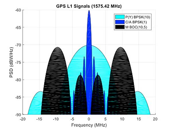
But the P(Y) code has its drawbacks in the modern world: its wide main lobe sits directly over the top of the C/A code signal (see Figure 1), essentially occupying the same spectrum. When the civilian C/A signal is jammed, the military P(Y) signal is at the very least degraded, if not also jammed itself. It also uses a relatively simple encryption scheme that does not meet today’s cyber security requirements.
Figure 1. C/A, P(Y), and M-Code signal power spectra. (Graphics: Mike Jones)
The M-code signal, on the other hand, is the first military GPS signal to use the BOC modulation scheme. BOC modulation gives signals their distinctive two-lobe appearance, spreading the signal’s energy away from the band center.
The wide spacing of the two sidebands separates the M-code signal from the civilian signals (the legacy C/A signal or the new L1C signal on the L1 frequency, and the L2C signal on the L2 frequency).
Amongst other things, this allows the military to jam the civilian codes without noticeably degrading the M-code signal. Often referred to as blue force electronic attack (BFEA), this is essentially a new facet to navigation warfare (NAVWAR), where enemy use of GPS can be denied whilst allowing friendly forces to continue using it.
The wider occupied bandwidth and increased signal power also help to make M-code more resistant to jamming. M-code also makes use of more modern and flexible encryption methods, ensuring it will be secure and safer from threats such as spoofing attacks.
Scepticism. Defense programs are known for their long procurement cycles, but even by these standards, M-code has taken an extremely long time to get where it is today. Given the enormous cost of the program, and the fact that there is still, as yet, no operational benefit to show from it, many people have questioned its worth. At the time it was conceived it represented a dramatic step forward in military capability but, because it has been so long in development, its operational benefit is becoming diluted.
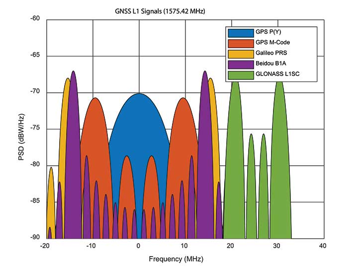
When M-code was conceived, GPS was still the only operational GNSS in town: everybody had to use GPS — or nothing. Today, the picture differs greatly. During M-code’s insanely slow progress, other GNSS systems have come along, offering their own encrypted signals of a similar ilk. Looking at Figure 2, M-code no longer appears as special as it once was. Its BOC(10,5) signal sits inside the main lobes of Europe’s Galileo PRS signal, which uses a BOC(15,2.5) scheme, and China’s Beidou B1A signal using BOC(14,2).
Figure 2. GNSS encrypted signals around the L1 frequency. (Graphics: Mike Jones)
If you were China, you might consider jamming the central 24 MHz of the L1 band, taking out M-code, whilst still having an operational military service for yourself. Or if you were Russia, you might jam 34 MHz of bandwidth, taking out the US, Chinese, and European systems, whilst still having your GLONASS L1SC military service to use. The situation is more complex than that, of course: each service has the potential to increase signal power in times of conflict, and there is more than one frequency that can be used. But it does demonstrate the essence of the problem: The modern battlespace has moved on, and M-code hasn’t.
CHALLENGES OF RECEIVER DESIGN
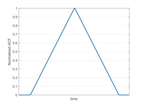
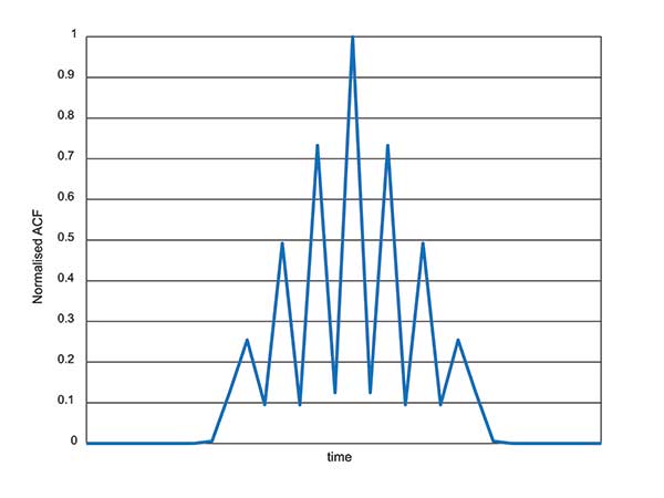
Figure 3. C/A code ACF.
With complex signals come complex receivers, and there several headaches when it comes to M-code receiver design. The first is the nature of the BOC signal itself, which has a complex correlation function. Consider Figure 3, which shows the autocorrelation function (ACF) of the traditional civilian C/A code signal. The single peak of the function makes acquisition and tracking a simple process; traditionally early, prompt and late (E,P,L) correlator arms can be used in the tracking process.
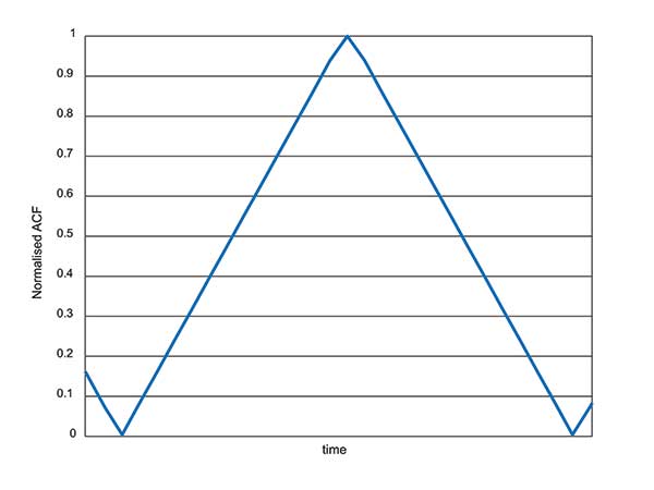
Figure 4. L1Cd ACF.
The newer BOC-type signals have a more complex ACF. Figure 4 shows the ACF of the new L1Cd civilian GPS signal, which uses a form of BOS(1,1) modulation. In addition to the main lobe, there are now two side lobes. Receivers must be careful not to lock on to one of the side lobes instead of the main lobe: the receiver architecture starts to become a little more complex.
Figure 5. M-code ACF.
Now consider the ACF of the M-code signal, shown in Figure 5. Like other high-order BOC-type signals, M-code exhibits multiple lobes in the ACF, making robust acquisition and tracking a far more troublesome process. Furthermore, the high bandwidths require high sample rates, which lead to higher power consumption in the hardware.
Another major headache associated with M-code receivers is, of course, the encryption process. Not because encryption is difficult, but again because of the power consumption implications. Consider that each GPS receiver needs to run an encryption engine instance, for each satellite it might wish to receive. Running a high-grade encryption algorithm at a high chipping rate, for a dozen satellites, is a power-consuming process. For dismounted soldiers with limited battery capacity, this is a big deal.
Some people argue that the high-grade encryption process for M-code is too complex. Consider why we want to encrypt a GNSS signal in the first place: firstly to prevent someone from spoofing our signal, and secondly to prevent unauthorised users from using the service. Given that the encryption keys are rolled regularly, how much does it matter if an adversary manages to compromise the encryption? This isn’t a communications security problem: we are not talking about loss of classified information, so there’s an argument that a simpler, less power-hungry form of encryption might have been used instead.
ANTI-JAM ANTENNA COMPATIBILITY
Although M-code offers a certain level of jamming resistance, it is still vulnerable to attacks. As a signal it might have a bit more power, and a bit more bandwidth, than some other signals. But it is, after all, still a GNSS signal, and it can be jammed by an adversary. Where an operational threat analysis indicates that an increased level of jamming resistance is required, then M-code receivers need to be integrated with anti-jam antennas.
Anti-jam antennas, usually referred to in the GNSS community as controlled reception pattern antennas (CRPAs), have been the anti-jam tool of choice for several decades now. I overviewed these in an April 2017 newsletter column. CRPA manufacturers have had to ensure that their products are “M-code ready,” such that they can be seamlessly attached to M-code receivers as and when they appear.
This hasn’t been a recent process: as far back as 2002, the GAS-1 antenna (Raytheon) underwent a series of qualification tests to ensure compliance with M-code. Around 2005, the ADAP antenna (also Raytheon) was launched with a host of M-code features — again an illustration of just how slow the M-code program has moved, given that other technology has been “M-code ready” for 10 or 15 years already.
What’s involved in making a CRPA M-code compatible? Firstly the increased bandwidth: the antenna electronics must digitize the wider bandwidths. Along with the wider bandwidth comes new filtering shapes to ensure optimum performance.
Space-time adaptive processing (STAP) and space-frequency adaptive processing (SFAP) techniques potentially require more taps to ensure high null depths can be maintained across the full bandwidth. The increased power of the M-code signal, particularly if features like spot beam are used, presents another complication to CRPAs: they must not treat the high-power satellite signals as jammers, and try to remove them.
Testing CRPAs presents a challenge to manufacturers: how do you prove that your antenna doesn’t corrupt the M-code signal, when there’s no M-code signal to test it with? To work around this issue, pseudo M-code signals have been used for testing, where representative BOC(10,5) signals without the real encryption are passed through the CRPA and examined for distortion.
RECEIVER DEVELOPMENT STATUS
Due to the security considerations surrounding M-code, only three US organizations are authorized to produce modules: Collins Aerospace, Raytheon and L3. Here are the answers from Collins Aerospace and L3, the answers from Raytheon will appear in later issue.
What are the technical challenges associated with developing an M-code receiver?
Collins Aerospace. The Collins Aerospace Modernized GPS User Equipment (MGUE) Increment 1 development like the SAASM PPS receiver developments faced very challenging technical requirements to support our war fighter needs in an ever-evolving threat environment. Like other complex developments the challenges are initially technical and then transition to integration/test and certification. On the technical front optimizing receiver performance balanced against power consumption are always at the forefront. In addition, it is important to maximize backwards compatibility so as to minimize downstream integration costs while adding an entirely new signal that runs in parallel to the existing system. Collins Aerospace is pleased with the technical development and are actively supporting the integration with both receivers and technical support.
To date, we have delivered more than 770 MGUE receivers to the Air Force to support Air Force, lead platform and DoD-wide Integration and test. Soon the total will grow to nearly 1,100 receivers to support expanded integration and test following the completion of Collins Aerospace security certification.
L3. M-code GPS User Equipment (MGUE) technologies exist today.L3’s Ground Based GPS Receiver Application Module – Modernized (GB-GRAM-M) is a fully-functioning unit that is currently baselined and undergoing an independent Technical Requirements Verification (TRV) by the GPS Directorate.During TRV, each requirement from the Technical Requirements Document (TRD) is independently evaluated for compliance. Upon completion of the TRV, the design is baselined with complete documentation enabling platforms and prime equipment to integrate from a known baseline with low risk. Following integration, operational testing can start immediately to support fielding when M-Code Early Use (MCEU) becomes operational. The TRV of L3’s GB-GRAM-M is planned to be completed by the second quarter of 2019.
L3 resolved numerous technical challenges in developing M-code GPS technologies. The first and ever-present challenge is changing and evolving requirements. Most of these requirement changes are in response to evolving threats that have driven changes into the GPS receiver and/or to higher-level systems. Asan example, the U.S. Army’s Assured PNT (A-PNT) is implementing M- code GPS along with external sensors to establish and maintain an assured solution even in GPS-challenged environments. Other challenging requirements include meeting the security requirements, implementing and testing anti-spoofing algorithms, and ensuring backward compatibility with legacy receivers.
What are the intended platforms for your MGUE?
Collins Aerospace. The Collins Aerospace MGUE receivers are intended to support all warfighter domains: ground, airborne, maritime and munitions to support compliance with Public Law 111-383 SEC. 913 issued in Fiscal Year 2011. Per this directive, M-code is intended for all DoD applications with the exception of passenger vehicles or commercial vehicles with GPS installed. Now that the satellite and control segments of the capability are coming on line, we are working diligently to ensure that user equipment is available for all domains.
L3. L3 has products to meet current market demand. Under the MGUE program, L3 developed a GB-GRAM-M, which is a standard Modular Open Systems Architecture (MOSA) design. The GB-GRAM-M is designed to fulfill retrofit replacements of SAASM receivers, as well as being a primary component of A-PNT systems. L3’s M2GRAM ASIC is the core of our receiver, a GPS module that incorporates signal processing, cryptography, and positioning, velocity, and timing (PVT) processing. The M2GRAM ASIC is capable of being implemented in other form factors for applications beyond ground-based applications. As an example, the M2GRAM is implemented in a GPS receiver specifically designed for Precision Guided Munitions (PGM) applications and was used in a gun launched, guide-to-target demonstration operating as a PGM receiver.
L3 is also augmenting the GPS receiver through the integration of several other technologies, including controlled reception pattern antennas with digital antenna electronics, inertial systems and external sensors, and GPS-denied capabilities. M-code technologies are being implemented in Mounted A-PNT Systems (MAPS), Dismounted A-PNT Systems (DAPS), and handheld systems to bring capabilities to the warfighter.
What is the expected timeline for your MGUE development, acceptance testing, and delivery?
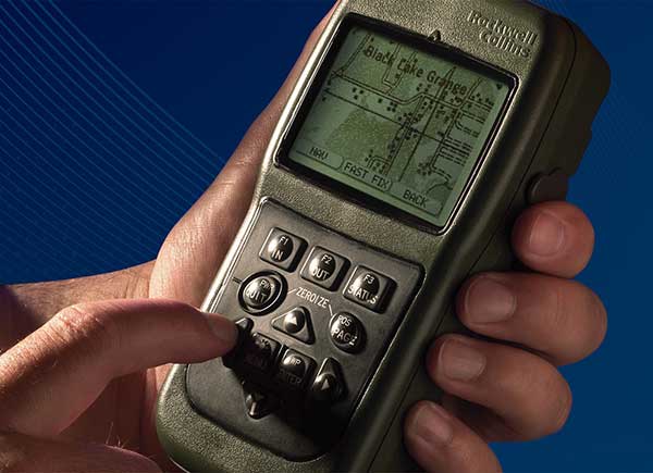
Defense Advanced GPs Receiver (DAGR) from Collins Aerospace, equipping infantry and other warfighters. (Photo: Collins Aerospace)
Collins Aerospace. The Collins Aerospace receivers are supporting ongoing DoD integration and test and our MGUE Increment 1 program is aligned with the Air Force GPS Enterprise roadmap. Ultimately, the Department of Defense (DoD) M-code programs will set the production delivery schedules.
We anticipate that the M-code production ramp-up and continued SAASM PPS receiver production will have a production overlap. Our Collins Aerospace in-house PPS GPS receiver manufacturing capability is ready to support the DoD demand for both M-code and SAASM. Collins Aerospace is fully committed to manufacturing Increment 1 M-code receivers to meet the warfighter’s needs across Airborne, Weapons and Ground, we know the transition from SAASM to M-code will take years. Therefore, Collins Aerospace will continue to manufacture SAASM receivers for years to come as the International MOD Policy for M-code use is still being formulated.
L3. L3’s GB-GRAM-M is now available. L3 received security certification and approval in 2016 and TRV is planned for completion in the second quarter of 2019. With TRV, L3 is receiving a new security certification and approval of the latest receiver update. Government agencies, prime contractors and laboratories can order GB-GRAM-M now with delivery in the fourth quarter of 2019.
What does testing and verification process involve?
Collins Aerospace. As with any Precise Positioning Service (PPS) GPS development, the testing involves functional verification of the receiver in a wide variety challenging of environmental, thermal, electromagnetic interference/ high-intensity radiated field (EMI/HIRF) environments. Collins Aerospace is leveraging proven test and verification approaches founded upon our long history of successful product introductions and field performance. As this is a PPS receiver it is also essential the receiver design comply with the government’s required Security Approval process.
L3. The testing and verification of L3’s GB-GRAM-M included internal testing and independent testing through the GPS Directorate’s TRV process. Further risk reduction testing within the MGUE program is planned as Phase IV testing where the GB-GRAM-M is integrated into a lead platform for the U.S. Army and a lead platform for the U. S. Marine Corps. An operational assessment is performed on both lead platforms to assure common problems associated with integration and operational testing are addressed prior to implementing M-Code GPS Receivers across all of the platforms.
Will the MGUE be compatible with CRPA anti-jam antennas; are there any special considerations for this?
Collins Aerospace. The Collins Aerospace product family includes our Digital Integrated Anti Jam Receiver (DIGAR) product family that leverages CRPA anti-jam antennas for enhanced anti-jam (AJ) performance. Our DIGAR AJ technology enhances the performance with fixed reception pattern antenna (FRPA), CRPA and is compatible with all PPS waveforms. Regarding the interfaces between the receiver and the anti-jam antenna electronics, a GPS receiver with a standard RF interface is compatible with a CRPA in nulling mode and FRPA antennas. Advanced capabilities such as beamforming/beamsteering require tight coordination and additional interface with the GPS receiver.
L3. The GB-GRAM-M is designed to operate with a fixed reception pattern antenna (FRPA). A CRPA antenna using digital antenna electronics to generate signals matching the characteristics of a FRPA is fully compatible with the GB-GRAM-M. With a higher level of integration of a GPS receiver and a CRPA, the system capabilities are greatly enhanced. L3 has performed this integration and can perform advanced capabilities such as angle of arrival and beamforming using M2GRAM, digital antenna electronics, and CRPA technologies. These capabilities can be found in L3’s Mounted Assured PNT System (MAPS) and Anti-Jam Antenna System (AJAS) products.
Army Stryker ground combat vehicle. (Photo: Karolis Kavolelis / Shutterstock.com)
OPERATIONAL DEPLOYMENT
The U.S. Air Force GPS Directorate provided answers to the following questions regarding MGUE.
Which platforms will be equipped with M-code-capable MGUE, and how many of each?
GPS Directorate. The Air Force is developing M-code-capable GPS receivers under the MGUE Increment 1 program. The receivers in development will be provided to four service-specific lead platforms for integration, developmental, and operational testing. Lead platforms are:
the Army Stryker ground combat vehicle,
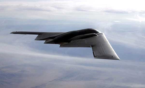
the Air Force B-2 Spirit bomber,
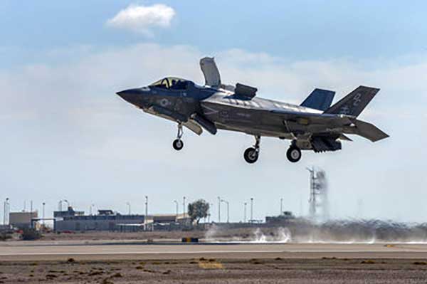
the Marine Corps Joint Light Tactical Vehicle (JLTV),
and the Navy Arleigh-Burke class destroyer (DDG).
Following the lead platform efforts, procurement of M-code-capable GPS receivers will be decided by the Services and executed by individual platforms and programs.
What are the timelines for rolling out M-code on these platforms?
GPS Directorate. Early integration and test activities have already begun for each MGUE lead platform. Operational testing is expected to begin in 2020 and complete in 2021, which is a key activity to enable the fielding of M-code-capable systems.
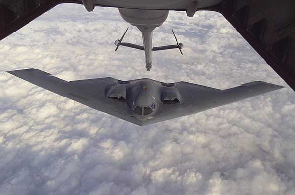
B-2 Spirit multi-role bomber capable of delivering both conventional and nuclear munitions. In December 2017, the Air Force completed a series of successful flight tests of M-code GPS using a Raytheon Company receiver on board a B-2 Spirit at Edwards Air Force Base, California. (Photo: U.S. Air Force/Bobby Garcia)
What advantages will M-code bring, over existing military GPS receivers?
GPS Directorate. Modernized GPS receiver cards under development with the Air Force MGUE Increment 1 program will enable the use of M-code and provide U.S. forces with enhanced position, navigation, and timing capabilities, in addition to improving resistance to threats, such as jamming efforts by adversaries.
How will keys and key distribution be managed?
GPS Directorate. None of this is publically releasable.
Will M-code be made available to other friendly nations? If so, how is this managed?
GPS Directorate. The current policy allows for the sale of M-code equipment to all 57 authorized GPS PPS nations. The M-code technology will be made available to these nations through the Foreign Military Sales process.
USER PERSPECTIVE
The Department of Defense supplied answers to the following questions for users and warfighters.
What are the benefits you perceive will come from new M-code GPS equipment?
DoD. Provides U.S. forces with enhanced position, navigation, and timing capabilities, in addition to improving resistance to threats, such as jamming efforts by adversaries.
Will it change how you perform military operations, or enable any new ones?
DoD. Modernized GPS receivers provide the next-generation GPS capabilities to the warfighter. Operational testing will enable the services to determine operational utility of MGUE. It will ensure our soldiers, sailors, airmen, and marines have the ability to get in, accomplish their mission, and get home accurately.
How will M-code-based GPS receivers be brought into operational service? Will there be a mass upgrade of assets, or a phased introduction?
DoD. Procurement of M-code-capable GPS receivers will be decided by the Services and executed by individual platforms and programs.
Earlier this year, Raytheon Company demonstrated a land-based expeditionary version of its Joint Precision Approach and Landing System (JPALS) for the first time to U.S. Air Force, Navy and Marine Corps officials at Marine Corps Air Station, Yuma, Arizona.
During the demonstration, F-35B pilots used the JPALS system on the jet to connect with the expeditionary system on the ground from 200 nautical miles away. From there, the system guided the pilot to a designated landing point on the runway.
“The need for precision landings in harsh environments isn’t limited to one military service and one airplane,” said Matt Gilligan, vice president at Raytheon’s Intelligence, Information and Services business. “JPALS can help any fixed or rotary-wing aircraft land in rugged, low-visibility environments at austere bases worldwide.”
The proof-of-concept event showed how the GPS-based system, which is currently used to guide F-35Bs onto ships in all weather, could be reconfigured into a mobile version to support landings in a traditional airport setting.
Infographic: Raytheon
Expeditionary JPALS supports the U.S. Air Force’s desire to use more austere, bare-base locations for future flying operations.
Currently in five transit cases, it could be repackaged for a variety of small transit vehicles transportable by C-130. Once on the ground, the system can be fully operational in under 90 minutes.
The U.S. Air Force’s second new GPS III satellite, bringing higher-power, more accurate and harder-to-jam signals to the GPS constellation, has arrived in Florida for launch.
On March 18, Lockheed Martin shipped the Air Force’s second GPS III space vehicle (GPS III SV02) to Cape Canaveral for an expected July launch.
Designed and built at Lockheed Martin’s GPS III Processing Facility near Denver, the satellite traveled from Buckley Air Force Base, Colorado, to the Cape on a massive Air Force C-17 aircraft. The Air Force nicknamed the GPS III SV02 “Magellan” after Portuguese explorer Ferdinand Magellan.
GPS III is the most powerful and resilient GPS satellite ever put on orbit. Developed with an entirely new design, for U.S. and allied forces, it will have three times greater accuracy and up to eight times improved anti-jamming capabilities over the previous GPS II satellite design block, which makes up today’s GPS constellation.
GPS III also will be the first GPS satellite to broadcast the new L1C civil signal. Shared by other international global navigation satellite systems, like Galileo, the L1C signal will improve future connectivity worldwide for commercial and civilian users.
The Air Force began modernizing the GPS constellation with new technology and capabilities with the December 23, 2018 launch of its first GPS III satellite. GPS III SV01 is now receiving and responding to commands from Lockheed Martin’s Launch and Checkout Center at the company’s Denver facility.
Lockheed Martin shipped the U.S. Air Force’s first GPS III to Cape Canaveral, Florida ahead of its expected July launch. (Photo: Lockheed Martin}
“After orbit raising and antenna deployments, we switched on GPS III SV01’s powerful signal-generating navigation payload and on Jan. 8 began broadcasting signals,” Johnathon Caldwell, Lockheed Martin’s Vice President for Navigation Systems. “Our on orbit testing continues, but the navigation payload’s capabilities have exceeded expectations and the satellite is operating completely healthy.”
GPS III SV02 is the second of ten new GPS III satellites under contract and in full production at Lockheed Martin. GPS III SV03-08 are now in various stages of assembly and test. The Air Force declared the second GPS III “Available for Launch” in August and, in November, called GPS III SV02 up for its 2019 launch.
In September 2018, the Air Force selected Lockheed Martin for the GPS III Follow On (GPS IIIF) program, an estimated $7.2 billion opportunity to build up to 22 additional GPS IIIF satellites with additional capabilities.
GPS IIIF builds off Lockheed Martin’s existing modular GPS III, which was designed to evolve with new technology and changing mission needs. On September 26, the Air Force awarded Lockheed Martin a $1.4 billion contract for support to start up the program and to contract the 11th and 12th GPS III satellite.
Once declared operational, GPS III SV01 and SV02 are expected to take their place in today’s 31 satellite strong GPS constellation, which provides positioning, navigation and timing services to more than four billion civil, commercial and military users.
A SpaceX Falcon 9 rocket lifts off from Space Launch Complex 4E at Vandenberg Air Force Base, California, Jan. 14. (Photo: SpaceX)
Starting this month, the inspector general for the U.S. Pentagon will be reviewing how SpaceX’s rockets became certified to launch payloads for the U.S. Air Force, a decision made in May 2015.
“Our objective is to determine whether the U.S. Air Force complied with the Launch Services New Entrant Certification Guide when certifying the launch system design for the Evolved Expendable Launch Vehicle-class SpaceX Falcon 9 and Falcon Heavy launch vehicles,” wrote Michael J. Roark, deputy inspector general for Intelligence and Special Program Assessments, in a Feb. 11 memorandum to the Air Force.
In April 2016, the U.S. Air Force awarded SpaceX the first competitively sourced National Security Space (NSS) launch services contract in more than a decade, when the company won the GPS III Launch Services contract, fixed at $82,700,000.
Less than one year later, SpaceX was awarded a second contract for launch services to deliver a GPS III satellite to its intended orbit.
The evaluation will be performed at the Space and Missile Systems Center, a unit of Air Force Space Command, headquartered at Los Angeles Air Force Base in El Segundo, California. Additional locations may also be identified as part of the audit.
Lockheed Martin has received a $172 million contract from the U.S. Navy and Air Force for Long Range Anti-Ship Missile (LRASM) production. The LRASM is designed to reduce dependence on GPS.
The contract continues the production for the air-launched variant of LRASM, including a full production run of missiles and engineering support. This is the second of several expected annual production lots that will deliver next-generation anti-ship missiles to the U.S. Navy and U.S. Air Force.
LRASM is designed to detect and destroy specific targets within groups of ships by employing advanced technologies that reduce dependence on intelligence, surveillance and reconnaissance platforms, network links and GPS navigation in electronic warfare environments.
LRASM will play a significant role in ensuring military access to operate in open ocean/blue waters, owing to its enhanced ability to discriminate and conduct tactical engagements from extended ranges.
LRASM is a precision-guided, anti-ship standoff missile based on the successful Joint Air-to-Surface Standoff Missile – Extended Range (JASSM-ER). It is designed to meet the needs of U.S. Navy and U.S. Air Force Warfighters in contested environments.
The air-launched variant provides an early operational capability for the U.S. Navy’s offensive anti-surface warfare Increment I requirement. With the recent EOC declaration by the U.S. Air Force for the B-1B, the focus is now on the U.S. Navy’s F/A-18E/F Super Hornet in 2019.
“LRASM brings a game-changing capability to both the U.S. Air Force and the Navy,” said David Helsel, LRASM director at Lockheed Martin Missiles and Fire Control. “This second production lot will provide anti-ship missiles for both the B-1B and F/A-18E/F, bringing sea control back to our warfighters.”