Advanced Scientific Concepts (ASC), supplier of 3D flash lidar vision systems for terrestrial, aerial and space applications, is creating of Advanced Scientific Concepts LLC, following the sale of its ASCar division to Continental AG.
With the acquisition of ASCar, Continental plans to mass produce flash lidars at an affordable price to support the commercial automotive industry.
Advanced Scientific Concepts LLC will continue to focus on providing 3D flash lidar custom and standard product solutions for space, manned airborne and underwater applications. This includes also providing UAS, autonomous vehicle and 3D mapping solutions for the domestic and international military markets.
“ASC’s product line for military and aerospace has matured over the past couple years to a high technology readiness level (TRL) through rigorous design and development,” said Jim Curriden, president of ASC LLC. “ASC LLC will now be entirely focused and well positioned to provide affordable solutions for the military and aerospace community by providing either off the shelf or tailored products to meet a user’s unique requirements.”
Advanced Scientific Concepts LLC is aimed at concentrating on the key markets at the foundation of their technology, ready to invest in the future advancement of 3D flash lidar.
Intergeo 2014 in Berlin hosted a flight zone event for unmanned aircraft systems (UAS) business applications, which led to the 2015 debut in Stuttgart, Germany, of Interaerial Solutions as an integrated topic platform. For the first time, Interaerial Solutions will run as a free-standing UAS platform Oct. 11–13 during Intergeo 2016 in Hamburg.
“Interaerial Solutions Expo. Forum. Flight Zone for UAS.” hosted by Hinte GmbH, now has a dedicated website, www.interaerial-solutions.com, and will serve as a showcase for manufacturers, UAS users and operators, accessories, software and end-to-end solutions.
The repositioning of Interaerial Solutions is the result of its organizers recognizing the rapid development of the UAS market and the high rate of innovation in this new technology. UAS manufacturing and the development of related solutions currently form the most dynamic growth generator in geo-based data capture, processing and the development of applications, Intergeo said in a news release.
“A new chapter in aviation history is unfolding, as UAS takes over the civilian market and unlocks huge potential for developing innovative applications in countless directions,” Christoph Hinte, CEO of Hinte, said in the news release. “We will be scripting the storyline at Interaerial Solutions. We are already the biggest platform in this field in the German-speaking world.”
Uwe Nortmann, managing director of UAV Dach e.V., Interaerial Solutions’ partner organization, already considers the Interaerial Solutions marketplace to be the leading trade fair for unmanned aircraft systems. “For me, the event’s main appeal lies in the way it reveals how a range of sectors can benefit from the fledgling technological developments surrounding UAS,” he said. “By replacing manned flights, UAS heralds vast potential savings in costs. The future lies in unmanned aircraft systems, and Interaerial Solutions is the platform to show this.”
About 80 exhibitors and approximately 3,200 visitors attended the event as part of Intergeo 2015. A third of those visitors placed an order at the trade fair or immediately afterwards, Intergeo said, and two-thirds of visitors at Interaerial Solutions rated Intergeo 2015 as either “important” or “very important” for investment decisions.
The event will maintain the same format this year as last year with an exhibition area, expert forum and outdoor flight zone. Exhibitors of the 2016 event include:
Suppliers of hardware for UAS.
UAS manufacturers.
Hardware manufacturers for remote sensing.
Manufacturers of UAS accessories.
Suppliers of evaluation software/photogrammetry.
Suppliers of UAS services.
Technology and services for data utilisation.
Education and training.
Service providers and dealers.
Insurersand consultants.
Publishers and associations.
Authorities.
“Interaerial Solutions already gave professional UAS manufacturers like us the chance last year to present our products to a large, enthusiastic trade audience,” said Daniel Schmitt, manager of RotorKonzept Multikoptermanufaktur. “At the same time, visitors to the trade fair were able to gain a comprehensive overview of the market. Interaerial Solutions is the most important exhibition platform of the year for RotorKonzept. We will definitely be on board again in Hamburg.”
A team from the National Oceanic and Atmospheric Administration (NOAA) and Raytheon has successfully demonstrated advancements of the Coyote Unmanned Aircraft System (UAS), verifying new technology that improves Coyote’s ability to collect vital weather data on hurricanes.
Coyote drops out of a P-3 weather surveillance plane, spreads its wings and flies straight at a hurricane, braving violent winds and punishing rain to gather weather data and beam it back to meteorologists.
Drew Osbrink and Eric Redweik of Sensintel and NOAA hurricane researcher Joe Cione monitor data from the Coyote as it flies into Hurricane Edouard in 2014. (Photo: NOAA)
Coyote solves a problem that has limited forecasters’ ability to tell how hard a hurricane will hit. The secret behind the storm’s punch lies in what is known as the “boundary layer” — a low-altitude area that includes the surface of the ocean. Because hurricanes are fueled by warm ocean water, information collected at the interface of atmosphere and ocean is vital to the understanding and prediction of a storm’s strength.
“That’s where the energy is extracted from the ocean to the atmosphere,” said Joe Cione, a NOAA hurricane researcher. “Unfortunately, it is too difficult for us to go with manned aircraft to fly down there.”
The Coyote can maneuver in the most violent regions of a hurricane.Traditional weather instruments parachute from a plane and grab only a snapshot of humidity, wind speed and other factors, but Coyote’s winged design enables it to linger and return to certain areas for more measurements.
“Coyote will gather data specifically in the eye wall where it can provide information for forecasters to predict intensity from a safe distance,” said John Hobday, Raytheon. “This is a significant difference for researchers: instead of providing a snapshot of data, it’s a full-length movie.”
The Coyote after a successful flight on Jan. 7. (Photo: NOAA)
Operational Upgrades
In a Jan. 7 test, the Coyote was released from NOAA’s Hurricane Hunter P-3 aircraft and flew over the Avon Park Air Force Range in Florida, to measure the transmission range of upgraded technologies. It set a new distance record for flight control and data transmission to the P-3, and provided hurricane forecasters with real-time data on atmospheric air pressure, temperature, moisture, wind speed and direction as well as surface temperature.
Data collected will help improve the accuracy of forecasts. “Here at the National Hurricane Center (NHC), we are keenly interested in obtaining measurements from the Coyote of the strongest winds near the center of the storm,” said Chris Landsea, science operations officer at NHC. “Coyote could help us paint a better picture of current storm intensity for our storm updates.”
In 2014, NOAA deployed four of the Coyote planes into Hurricane Edouard, a Category 3 storm, at controlled altitudes as low as 400 feet. Scientists on board the P-3 received meteorological data in both the eye of the storm and the eye wall.
However, the P-3 had to fly 5 to 7 miles from the Coyote to pick up its signal. So engineers at Raytheon and the NOAA Aircraft Operations Center upgraded Coyote’s sensor systems and improved its communications package to allow it to talk to the plane over longer distances. Now, Coyote can fly for 50 miles away from the launch aircraft, which will be free to continue its own mission.
Coyote also was outfitted with an upgraded instrument package that includes an infrared sensor to measure sea surface temperature, which will help scientists understand how a hurricane extracts energy from the ocean — and how it might intensify or change. The team also is working toward optimizing battery life.
The test flight verified the Coyote’s ability to transmit the data collected from its instrument package to operators aboard the P-3 as well as at the NHC, where personnel monitor storms and develop forecasts.
NOAA scientist Paul Reasor demonstrates the Coyote. (Photo: NOAA)
As the 2016 legislative session kicked off this month, the Association for Unmanned Vehicles Systems International (AUVSI) has been tracking all active legislation pertaining to unmanned systems. This year, to provide the best information to its members, legislators, regulators and the media, AUVSI has organized data on all unmanned systems-related state legislation into a sortable, interactive map with details that include a summary of each bill.
Included are bills that place restrictions on police, recreational or commercial unmanned aircraft systems; legislation that forms unmanned systems or autonomous vehicle commissions and task forces; bills that try to treat unmanned technology differently than other information-gathering devices; and bills that place operating limitations on unmanned aerial systems (UAS) in specific scenarios such as preventing all UAS from flying over prisons or from interfering with hunting and fishing.
To date, more than 150 active bills in more than 30 states have either carried over from 2015 or been introduced this year.
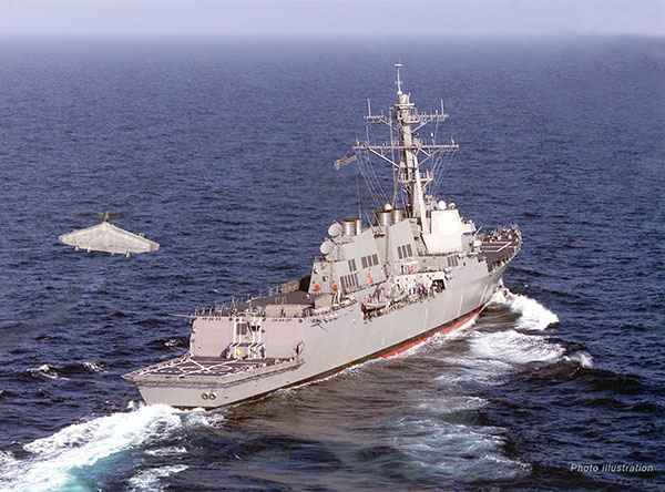
An illustration of Tern, Northrop Grumman’s next-generation unmanned system for maritime ISR and strike. (Image: Northrop Grumman)
The Defense Advanced Research Projects Agency (DARPA) and the Office of Naval Research have awarded Northrop Grumman the third phase of the Tern unmanned systems program. Phase three plans include final design, fabrication and a full-scale, at-sea demonstration of the system.
Tern seeks to develop an autonomous, unmanned, long-range, global, persistent intelligence, surveillance, reconnaissance (ISR) and strike system intended to safely and dependably deploy and recover from small-deck naval vessels with minimal ship modifications.
Designed to operate in harsh maritime environments, Tern aims to enable greater mission capability and flexibility for surface combat vessels without the need for establishing fixed land bases or requiring scarce aircraft carrier resources.
According to DARPA, Tern would use smaller ships as mobile launch and recovery sites for medium-altitude long-endurance (MALE) unmanned aircraft (UAVs). Named after the family of seabirds known for flight endurance — many species migrate thousands of miles each year — Tern aims to make it much easier, quicker and less expensive for the Department of Defense to deploy persistent airborne intelligence, surveillance and reconnaissance (ISR) and strike capabilities almost anywhere in the world.
Ideally, Tern would enable on-demand, ship-based unmanned aircraft systems (UAS) operations without extensive, time-consuming and irreversible ship modifications. It would provide small ships with a “mission truck” that could transport ISR and strike payloads to very long distances from the host vessel. The solution would support field-interchangeable mission packages for both overland and maritime missions. It would operate from multiple ship types and in elevated sea states.
Northrop Grumman’s Tern solution seeks to provide an innovative system that integrates mature and advanced technologies, including a distinctive propulsion solution designed to help expand global persistent ISR/strike capabilities for small-deck naval surface vessels.
“We intend to highly leverage our Unmanned Systems Center of Excellence to develop and demonstrate this type of demanding unmanned systems capability to advance the Navy’s mission,” said Chris Hernandez, vice president, research, technology and advanced design, Northrop Grumman Aerospace Systems. “We believe our unique ship-based unmanned systems experience, expertise, and lessons learned from programs including our MQ-8B/C Fire Scout, MQ-4C Triton, X-47A Pegasus and X-47B UCAS, is critical to the success of the Tern.”
“Using an innovative design that integrates vertical take-off and landing transitioning to an efficient flying-wing for cruise, our team is creating a system that we believe would achieve Tern’s revolutionary performance objectives in support of our combatant commanders,” said Ralph Starace, director, advanced design, Northrop Grumman Aerospace Systems. “Our full-scale demonstrator system is highly traceable to our operational concept to burn down risk, resulting in a compelling step forward for this game-changing, multi-mission capability,” said Bob August, Tern program manager, Northrop Grumman Aerospace Systems.
The Northrop Grumman Tern team includes its wholly owned subsidiary Scaled Composites, as well as General Electric (GE) Aviation, AVX Aircraft Company and Moog.
In August, U.S. Army Gray Eagle unmanned aircraft took part in manned-unmanned teaming exercises in South Korea, including streaming video and metadata to an AH-64 Apache helicopter while in flight.
Exercise support was conducted from Kunsan Air Base, South Korea, and represent a milestone for the MQ-1C Gray Eagle, proving its ability to conduct operations in diverse weather condition, according to manufacturer General Atomics Aeronautical Systems (GA-ASI).
During the exercise, the Gray Eagle UAS streamed video and metadata via a line-of-sight data link directly to the helicopter from extended distances. The Apache then retransmitted the imagery to a One System Remote Video Terminal (OSRVT), allowing field commanders within the Tactical Operations Center (TOC) to receive both live Gray Eagle streaming video and retransmitted video sent by the Apache. Once the Gray Eagle was airborne, U.S. ground forces passed contact reports and target coordinates to operators in the aircraft’s ground control station. The operators were then able to direct the Gray Eagle’s sensors to positively identify and track the targets.
The Gray Eagle is used by the Army for reconnaissance, surveillance, communications, convoy protection, IED detection and precision weapons delivery.
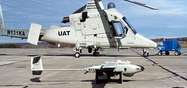
Lockheed Martin has demonstrated its ability to integrate unmanned aircraft system (UAS) operations into the National Airspace System (NAS) using its prototype UAS Traffic Management (UTM) capabilities.
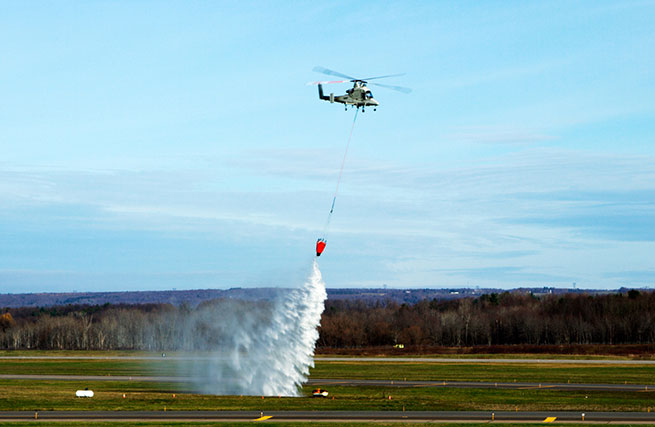
During the demonstration on Nov. 18, the Stalker XE UAS provided data and a precise geolocation to the unmanned K-MAX cargo helicopter, which conducted water drops to extinguish a fire, while the UTM tracked the UAS operations and communicated with Air Traffic Control in real time.
The Stalker UAS directs the unmanned K-MAX cargo helicopter to conduct water drops at a precise location to extinguish a fire. (Photo: Lockheed Martin)
“This demonstration represents the path forward for flying UAS in the NAS using Flight Service-based UTM capabilities to extend the technology and systems that air traffic controllers know and understand,” said Paul Engola, vice president, Transportation & Financial Solutions. “We were able to successfully modify the existing K-MAX and Stalker XE ground control software to connect to the UTM services and conduct the firefighting mission.”
For more than 80 years, manned aircraft have supported firefighting missions during daylight hours. Because unmanned K-MAX can fly day and night, in all weather, its insertion into firefighting operations offers the potential to triple the amount of time ground firefighters can receive aerial support.
The Stalker XE UAS worked in tandem with K-MAX to identify hot spots and fire intensity with its electro-optical, infrared camera. Its stable, high-definition imaging capabilities enable day and night operations. Powered by a ruggedized solid oxide fuel cell, Stalker XE achieves more than eight hours of flight endurance.
The Stalker and K-MAX operated in collaboration with a prototype UAS Traffic Management (UTM) system, which provides essential capabilities to enable safe UAS operations. (Photo: Lockheed Martin)
Topcon Positioning Group announces a new partnership with digital photogrammetric solution provider Agisoft LLC. The agreement is designed to further expand the Topcon solutions portfolio for mass data collection (MDC).
Agisoft is a world leader in the processing of digital imagery in order to generate high-accuracy 3D spatial data using photogrammetric and computer vision techniques, and has been developing imaging solutions for nearly 10 years. Topcon will provide the Agisoft Photogrammetric Kit for Topcon — Professional Edition software for post-processing of data collected using the Falcon 8 and Sirius Pro unmanned aerial systems (UAS).
Features include photogrammetric triangulation, dense point-cloud editing and classification, digital terrain or surface model export to a variety of formats including georeferenced orthomosiac production (including GeoTIFF and KML export), multi-spectral imagery processing, 3D model generation and texturing, as well as full measurement analysis tools.
“We are very excited to be able to offer the combination of our Sirius Pro and Falcon 8 UAS devices and Agisoft Photogrammetric Kit Professional software. The solution provides an integrated workflow for reaching high-accuracy survey results using unmanned aerial systems with minimal field work,” said Eduardo Falcon, executive vice president and general manager for the Topcon GeoPositioning Solutions Group. “For example, when using the Sirius Pro, absolute accuracies down to 1.6 cm (0.6 in.) in plan and 2.7 cm (1 in.) in height are possible without the need for any ground control.”
A proposed national drone registration system should be based on the pilot, not the craft, recommends an FAA task force. It should also be free, electronic and immediate, and not apply to UAVs weighing 250 grams or less.
In October, U.S. Transportation Secretary Anthony Foxx and Federal Aviation Administration (FAA) Administrator Michael Huerta announced the creation of the task force to develop recommendations for a registration process for unmanned aircraft systems (UAS).
The Task Force agreed that it was outside its scope to debate the Department of Transportation (DOT) Secretary’s decision to require registration of sUAS or the legal authority for the implementation of such a mandate.
Immediately following the DOT’s announcement in October, the FAA brought together retailers, pilots, industry representatives and others to talk about the proposal and submit comments on how the system should work.
Task force members interviewed FAA officials, met for three days and prepared final recommendations. They agreed on three basic requirements: Owners must fill out an electronic form, immediately receive a certificate of registration and number for use on all UAVs they own, and mark all applicable drones with a registered number.
The Task Force recommendations for the registration process are:
Fill out an electronic registration form through the web or through an application (app).
Immediately receive an electronic certificate of registration and a personal universal registration number for use on all sUAS owned by that person.
Mark the registration number (or registered serial number) on all applicable sUAS before their operation in the National Air Space (NAS).
The Task Force recommended an exclusion from the registration requirement for any small unmanned aircraft weighing a total of 250 grams or less. The exclusion was based on a maximum weight that was defined as the maximum weight possible including the aircraft, payload, and any other associated weight. In manned aircraft terms, it is the “maximum takeoff weight.”
CACI International has released SkyTracker, a precision system to protect high-value assets and support public safety against the escalating threat posed by the inadvertent or unlawful misuse of unmanned aircraft systems (UAS).
SkyTracker’s UAS detection, identification, and tracking system uses the drone’s radio links to precisely identify and locate UAS flying in banned or protected airspace, and has the unique capability to locate UAS ground operators. This proprietary CACI technology has been demonstrated to address a variety of UAS threat scenarios. The system is widely applicable, from protecting airports to safeguarding critical infrastructure or events — anywhere UAS pose a potential risk to people or assets.
On Oct. 7, the FAA announced a Pathfinder agreement with CACI to test SkyTracker in the airport environment to ensure successful operation without disruption of airport communications.
SkyTracker accurately detects, identifies, and tracks UAS threats. The system’s mitigation capability provides responders with precise information in a defined geographic location in order to initiate countermeasures that, unlike other technologies, do not interfere with legitimate electronics or communications systems in the area, or with UAS that are being operated responsibly as determined by the U.S. government.
The SkyTracker system design is modular and scalable for application in different environments. It can protect high-value assets in geographically compact locations such as government buildings, embassies and stadiums, as well as provide wide-area defense of airports, military bases and areas under temporary flight bans such as locations experiencing forest fires. SkyTracker provides continuous, automated monitoring, day or night, in any weather condition.
“CACI’s SkyTracker system provides our customers with the unique capability to precisely locate unmanned aircraft systems and their ground operators. Our system has been demonstrated to address a variety of UAS threat scenarios,” John Mengucci, CACI’s chief operating officer and president of U.S. Operations, said. “In addition to the protection of airports, an effort undertaken in our recently announced research and development agreement with the federal government, SkyTracker has broad applications in the protection of critical infrastructure, stadiums, events, or anywhere drones pose a potential risk to people or assets.”
“CACI is proud to advance our SkyTracker solution to address the rapidly escalating threat posed by the misuse of unmanned aircraft systems,” said CACI President and CEO Ken Asbury. “The development of innovative technological solutions in response to complex security threats is in our DNA. We built SkyTracker to address one of the most complex challenges facing those responsible for protecting critical infrastructure.”
CACI provides information solutions and services in support of national security missions and government transformation for intelligence, defense, and federal civilian customers. A Fortune magazine World’s Most Admired Company in the IT Services industry, CACI is a member of the Fortune 1000 Largest Companies, the Russell 2000 Index, and the S&P SmallCap600 Index. CACI provides dynamic careers for over 16,300 employees in 120 offices worldwide.
The City of Denver has contracted with the Sanborn Map Company Inc. to collect high-resolution, full-motion video imagery of the city’s seven public golf courses and its Aqua Golf facility.
Sanborn employs a commercial-grade unmanned aircraft system (UAS) from Denver-based Leptron Unmanned Aircraft Systems. The UAS is capable of producing unprecedented accuracy and resolution, including high-quality, engineering-grade digital terrain models exceeding 2-inch accuracy; multispectral frame imagery at sub-centimeter resolution; and crisp, vibration-free video. Earlier this year, the Federal Aviation Administration granted Sanborn a Section 333 Exemption, which permits the firm to offer commercial UAS services nationwide.
“We launched our new golf website earlier this year and now we look forward to adding the Sanborn imagery,” said Leslie Wright, Denver Golf director of marketing. “Our course locations range from densely populated urban areas to mountainous terrain with elevations above 7,000 feet. We also had a very tight window in which to perform the work. Considering these diverse challenges, Sanborn has approached the project with a high degree of professionalism and has been great to work with.”
The city will use the images for marketing, as well as to give golfers a bird’s-eye view of every hole with realistic fly-overs down each fairway from the tee box to the green. The city’s Overland Park Golf Course is the oldest operating course west of the Mississippi River, according to a news release from Sanborn.
“Sanborn’s UAS technology is a great fit for a host of customers,” said Sanchit Agarwal, director of mapping operations. “Among them are police and fire departments, agricultural operations, utilities, oil and gas concerns, emergency response managers, local government, mine operators and the media.”
Sanborn acquired this bird’s-eye view video of the 17th hole at Denver’s Evergreen Golf Course with its commercial-grade UAV.
The U.S. Army’s Armament Research, Development and Engineering Center (ARDEC), located at Picatinny Arsenal in north-central New Jersey, has issued a sources sought notice for technology it can use for a variety of unmanned systems.
The notice says that technologies developed for the Autonomous Unmanned Systems Teaming and Collaboration In GPS Denied Environments program (AUSTC) could be used for small UAS, underwater vehicles and ground vehicles.
The center plans to to “identify, invest, mature and transition revolutionary/game-changing autonomous unmanned sensing technologies.”
“The AUSTC program employs a ‘think-tank’ and modified ‘skunk-works’ approach to identify and determine best path forward for new and game-changing technologies that may be available or in development to achieve U.S. Army RDECOM-ARDEC interest Sensitive Target Site Exploitation (STSE) mission,” the notice reads.