MAPPS has accepted an invitation from the Federal Aviation Administration (FAA) to be a member of the UAS Registration Task Force (RTF) Aviation Rulemaking Committee (ARC).
MAPPS is a national association of private-sector firms in the surveying, spatial data and geographic information systems field in the United States and a leader on the use of unmanned aircraft systems in the geospatial field.
The UAS RTF ARC was announced on Monday by Transportation Secretary Anthony Foxx to help minimize potentially unsafe UAS operations and incidents. The task force will work to develop minimum requirements for a UAS registration process for safe integration of UAS into the National Airspace.
MAPPS has tapped John Perry, founder and CEO of Altavian based in Gainesville, Fla., to represent the association on the task force.
“We are pleased and honored that the FAA has invited MAPPS to participate in the UAS RTF ARC,” said MAPPS President Susan Marlow. “MAPPS has actively called on the FAA to move forward with UAS rulemaking, and we are thrilled to be a part of the process.”
MAPPS has been a voice for the commercial use of UAS for geospatial data acquisition. The association has been engaged with FAA on UAS issues since 2009 and testified before state legislatures and participated in Congressional roundtables. MAPPS Executive Director John Palatiello was appointed to serve on the Federal Aviation Administration (FAA) working group on beyond visual line of sight (BVLOS) operations of commercial unmanned aircraft systems (UAS), and the association serves on a committee of the National Conference of State Legislatures (NCSL) to develop policy recommendations to the 50 state legislatures on UAS.
On Nov. 17-18, MAPPS will host sessions on geospatial activities at Drone World Expo, at the San Jose Convention Center in San Jose, Calif. The geospatial content will explore factors to consider when planning the start-up of a stand-alone UAS business, or a department in an existing surveying or mapping firm. It will kick off with a presentation on “What You Need to Know Before Starting Up Your Unmanned Aircraft System (UAS) Department,” as well as instruction on issues including system operating limitations, flight training, crew responsibilities, operator authority, client expectations, standards and licensing. Speakers at the policy conference will include Bryan Baker, UAS sales manager, Leica Geosystems; Jeff Lovin, senior vice president, director of Geospatial Services, Woolpert; Andy Nickerson of Aerovel Corp.; Mike Tully, president, Aerial Services, Inc.; and David Yoel, CEO, American Aerospace, Inc.
PrecisionHawk will serve as a technical resource to regulators. (PRNewsFoto/PrecisionHawk)
PrecisionHawk is contributing to a safety task force created by the U.S. Department of Transportation and the FAA. The task force brings together a diverse group, representing the UAS and manned aviation industries, the federal government, and other stakeholders, to develop an augmented registration process for Unmanned Aircraft Systems.
“PrecisionHawk is working on many safety solutions, procedural and technological, that we believe can contribute to safer operations for commercial drones in the national airspace,” said Ernest Earon, PrecisionHawk CTO and co-founder. “The creation of this task force further demonstrates the willingness of the FAA to move forward with industry leaders to promote rapid and safe integration.”
“As a UAS technology company and operator, we know how important coordinated identification is to the environments in which we work,” said Thomas Haun, VP of Strategy at PrecisionHawk. “The goal of this task force, to create a streamlined registration process for UAS, will have a direct and positive impact on the operations of our partners and service teams.”
“This task force presents another opportunity for PrecisionHawk to serve as a technical resource to regulators as we move towards the adoption of UAV regulations. Earlier this year PrecisionHawk was also named, alongside CNN and BNSF, to the FAA Pathfinder Program to test and develop technology solutions to solve beyond line of sight operations,” PrecisionHawk said in a statement.
UPDATE: Read news of the official announcement here.
The federal government is expected to announce today a new plan requiring anyone buying a drone to register the device with the U.S. Department of Transportation. The registration of the drone will enable authorities to track a drone back to its owner if used in a dangerous manner.
Under the plan, the DOT would work with the drone industry to set up a structure for registering the drones, and the regulations could be in place by Christmas.
The government has been concerned about the rise in close calls between unmanned drones and aircraft flying into and out of some of the nation’s biggest airports. In July, a passenger jet preparing to land at New York’s John F. Kennedy International Airport had a close call with a drone, which was 100 feet away from the jet at an altitude of 1,700 feet. Normal safe separation distance is between aircraft is at least 1,000 feet.
Private drones were also blamed for hampering aerial firefighting efforts over a California blaze in July. Firefighting aircraft trying to attack the fast-moving blaze in the Cajon Pass had to leave the area for around 20 minutes over safety concerns, officials said. That fire swept over a freeway and burned 20 vehicles.
On Oct. 6, the FAA announced the largest civil penalty proposed yet — $1.9 million — against a UAS operator for endangering the safety of the national airspace.
Brian Wynne, president & CEO of the Association for Unmanned Vehicle Systems International (AUVSI), released the following statement on today’s announcement that he is joining the U.S. Department of Transportation’s Task Force to develop a streamlined registration process for unmanned aircraft systems (UAS):
“AUVSI welcomes the opportunity to join this task force of government and industry stakeholders. This collaborative effort to develop an efficient process for UAS registration should lead to increased accountability across the entire aviation community.
“Under the FAA’s proposed small UAS rules released earlier this year, commercial operators would be required to register their platforms. Extending this requirement to other UAS users will help promote responsibility and safety.
“In addition to UAS registration, it is essential for the FAA to finalize its small UAS rules as quickly as possible. Once this happens, we will have an established framework for UAS operations, allowing anyone who follows the rules to fly. Considering that safety is at stake, time is of the essence to finalize the rules.
“Because safe operations are essential for all users of the national airspace, AUVSI is also looking forward to continuing its work with the FAA, the Academy of Model Aeronautics and more than two dozen supporters of the ‘Know Before You Fly’ campaign to educate newcomers to UAS technology about safe and responsible flying.”
Data is curated by SpecOut.com and sourced from the Center for the Study of the Drone at Bard College.
The Federal Aviation Administration (FAA) has entered into a Pathfinder agreement with CACI International Inc. to evaluate how the company’s technology can help detect Unmanned Aircraft Systems (UAS) in the vicinity of airports.
In testimony today before the House Aviation Subcommittee, FAA Deputy Administrator Mike Whitaker said that flying an unmanned aircraft near a busy airfield poses an unacceptable safety hazard. During the hearing “Ensuring Aviation Safety in the Era of Unmanned Aircraft Systems,” Whitaker told the congressional panel the FAA signed an agreement this week to assess the safety and security capabilities of CACI’s product within a five-mile radius of airports, and the agency also will collaborate with its government partners.
A steep increase in reports of small unmanned aircraft in close proximity to runways is presenting a new challenge for the FAA. It is the agency’s responsibility to identify possible gaps in safety and address them before an incident occurs.
CACI’s prototype UAS sensor detection system will be evaluated at airports selected by the FAA. The agency and its federal government partners will work with the company to evaluate the effectiveness of the technology, while also ensuring that it does not interfere with the safety and security of normal airport operations.
The CACI partnership is part of the larger UAS Pathfinder Program, which the FAA announced in May. Pathfinder is a framework for the agency to work closely with industry to explore the next steps in unmanned aircraft operations beyond those proposed in February in the draft small UAS rule.
“Safety is always the FAA’s top priority, and we are concerned about the increasing number of instances where pilots have reported seeing unmanned aircraft flying nearby,” said Whitaker. “We are looking forward to working with CACI and our interagency partners to identify and evaluate new technologies that could enhance safety for all users of the nation’s airspace.”
“CACI is proud to partner in the FAA’s Pathfinder cooperative research and development agreement to address the escalating Unmanned Aircraft Systems safety challenges that airports are facing nationwide,” said John Mengucci, CACI’s CEO and president of U.S. operations. “The agreement provides a proven way to passively detect, identify, and track UAS — or aerial drones — and their ground-based operators, in order to protect airspace from inadvertent or unlawful misuse of drones near U.S. airports. This CACI-built solution will help ensure a safe, shared airspace while supporting responsible UAS users’ right to operate their aircraft.”
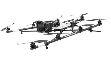
Topcon Positioning Group has added a rotary-wing unmanned aerial system (UAS) to its mass data-collection solutions line. The Falcon 8 — powered by Ascending Technologies — is designed for inspection and monitoring, as well as survey and mapping applications.
“Rotary-wing systems provide the perfect solutions for small-scale sites and projects for which flexibility of takeoff and landing or an oblique perspective is required,” said Charles Rihner, vice president of the Topcon GeoPositioning Solutions Group. “The Falcon 8 offers the flexibility to maneuver in small spaces and can cope with challenging environments often presented in inspection and monitoring. It is also well suited for smaller mapping or modeling projects up to 85 acres that require high-resolution imaging.”
The Falcon 8 features new AscTec Trinity technology, an autopilot safety feature that provides three levels of redundancy for protection against performance drop or loss of control. Three IMUs (inertial measurement system) synchronize all sensing data and identify, signal and compensate when needed.
Two models are available — the GeoEXPERT for surveying, modeling and mapping projects, and InspectionPRO for industrial inspection and monitoring applications. The GeoEXPERT includes a HD RGB camera payload, while the InspectionPRO features an HD RGB camera and infrared sensor combination.
“Both versions offer easy deployment and operation with real-time video and data monitoring capability, navigation software for planning and optimizing flights, as well as photo-tagging and desktop software to quickly generate high-quality and easy-to-edit material,” said Rihner.
The Falcon 8 complements the Topcon Sirius Pro fixed-wing UAS, providing large area accurate mapping without the requirement for traditional ground control.
Denver International Airport and the Federal Aviation Administration (FAA) are partnering to raise awareness about safe unmanned aircraft operations.
The agencies teamed up on a public service announcement that will run on the video towers in the airport’s main terminal. The PSA uses the “No Drone Zone” slogan to drive home the point that flying an unmanned aircraft near a manned aircraft is illegal and dangerous. It refers viewers to the FAA’s unmanned aircraft website and to the knowbeforeyoufly.org website for further information and guidance on flying unmanned aircraft safely and responsibly.
The PSA will air all day today following its unveiling at an unmanned aircraft safety press event that the airport organized and hosted. After that, it will air for two weeks surrounding the winter holidays — a time when many people will be getting drones as gifts.
Denver also will post the PSA on the airport website so it will reach travelers every day of the year.
The FAA has partnered with leading unmanned aircraft industry and hobbyist groups in the Know Before You Fly education campaign, and the campaign materials are now featured in product packaging for several types of UAS.
senseFly has published a white paper named “Generating highly accurate 3D data using a senseFly eXom drone” which presents the results of two photogrammetric land surveys of a construction site. The project was completed earlier in September using two senseFly eXom close mapping and inspection drones, and the announcement was made during INTERGEO, held Sept. 15–17 in Stuttgart, Germany.
The results demonstrate that 3D point clouds produced with an eXom quadcopter can reach a global precision comparable to that of a total station survey and meet the typical accuracy requirements of construction projects, according to a news release from senseFly.
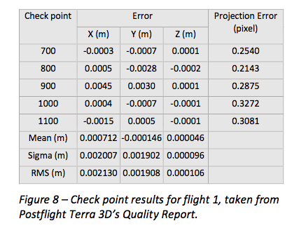
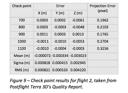
The first eXom survey (figure 8) achieved 2.1 millimeter accuracy in X, 1.9 millimeter in Y and 0.1 millimeter in Z (RMSE). The second eXom survey (figure 9) achieved 0.8 millimeter (X), 0.5 millimeter (Y) and 4.2 millimeter (Z).
“This degree of absolute accuracy from a drone is unparalleled and positions the eXom as a surveying instrument that is comparable in performance to standard total stations,” said Andrea Halter, senseFly’s co-founder. “These results were due, in part, to the high 38 MP resolution and sharpness of the flight’s images, captured by the main camera inside eXom’s TripleView head. Add to this image quality the ability to operate close to the terrain and the introduction of highly precise ground controls and you have a recipe for exceptionally accurate 3D data.”
Two eXom drones flew separate survey missions at an altitude of 14 meters above the site, achieving an average ground sampling distance (GSD) of 2.2 millimeters, senseFly says. All the flights were completed using the drone’s Interactive ScreenFly flight mode, whereby the UAV (unmanned aerial vehicle) is controlled using a handheld ScreenFly controller connected to senseFly’s eMotion X flight planning and control software.
This flight mode’s “cruise control” feature, combined with its auto-trigger function, enabled each of the eXom drones to survey the 1,100-square-meter site in a single flight. Meanwhile, the live on-screen feedback from the drone’s five different navcams and ultrasonic proximity sensors helped the operator ensure that no contact was made with either the on-site crane or any the trees surrounding the complex site, senseFly says.
“This project’s flights took place at 14 meters above the ground, but with the eXom’s Distance Lock feature we are able to safely fly just 4 meters away, so it isn’t unrealistic to think that the accuracy we achieved could be improved still further.”
To download the eXom accuracy white paper click here.
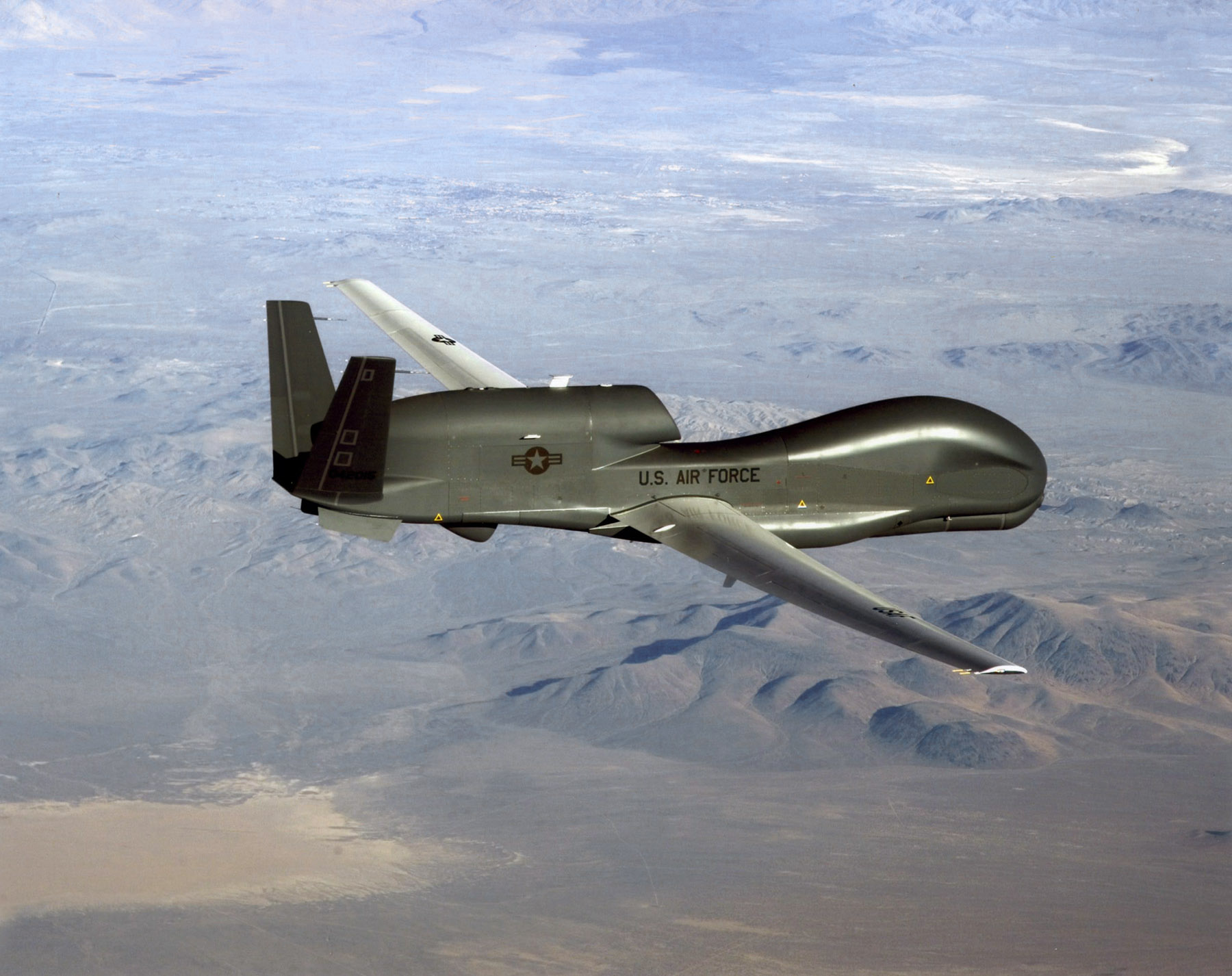
An RQ-4 Global Hawk soars through the sky to record intelligence, surveillence and reconnaissance data. (Courtesy USAF)
Curtiss-Wright Corporation’s Defense Solutions division was honored by Northrop Grumman for its role as a supplier in support of the RQ-4 Global Hawk unmanned aircraft system (UAS).
Global Hawk has flown 150,000 total flight hours supporting diverse global missions. Carrying a variety of intelligence, surveillance and reconnaissance sensor payloads, Global Hawk supports anti-terrorism, humanitarian assistance, disaster relief, airborne communications and information-sharing missions.
A ceremony was held Aug. 19 at Curtiss-Wright’s Integrated Systems facility in Santa Clarita, Calif., for the program to receive the James G. Roche Sustainment Excellence Award for a third year in a row. During the ceremony, an award was presented by Mick Jaggers, Global Hawk UAS vice president and program manager, Northrop Grumman Aerospace Sector, and accepted by Lynn Bamford, senior vice president and general manager, Defense Solutions division. The event was also attended by Rep. Steve Knight, U.S. Congressman for California’s 25th District.
(From left) Knight, Bamford and Jaggers with the award.
“We extend our sincerest congratulations to the US Air Force on this award and Northrop Grumman for their stellar job as the prime contractor on the milestone setting RQ-4 Global Hawk UAS,” said Ms. Bamford. “We take great pride in Curtiss-Wright’s role as an industry leader in providing advanced rugged electronics that help lower this important aircraft’s cost through the use of commercial-off-the-shelf technologies.”
During the ceremony, Jaggers remarked, “An aircraft as sophisticated as the Global Hawk comes together with the help of many partners, and one of the most crucial sustainment partners on the Global Hawk is Curtiss-Wright.”
The Sustainment Excellence Award is granted by Headquarters U.S. Air Force Logistics, Installations and Mission Support. It is named for Dr. James G. Roche, the 20th Secretary of the Air Force, a position he held from 2001 to 2005.
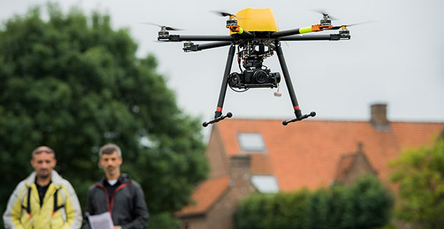
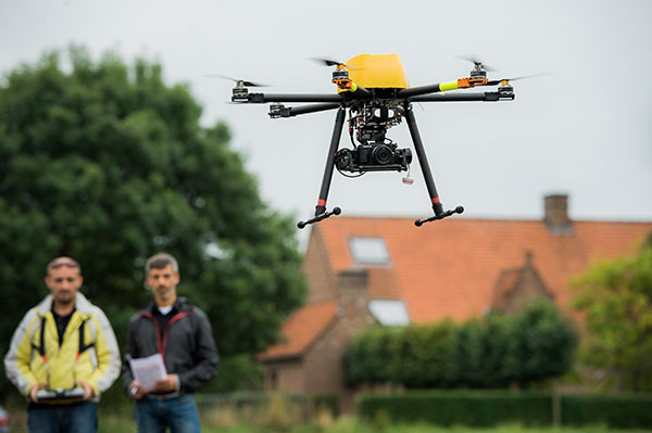
The Trimble ZX5 can reach smaller, remote environments faster, while providing accurate mapping data.
Trimble’s new ZX5 Multirotor Unmanned Aircraft System (UAS) — announced today — is an aerial imaging and workflow solution that captures and processes geo-referenced photo and video data for mapping, agriculture and inspection applications. The Trimble ZX5 complements the UAS portfolio with the ability to reach smaller, remote environments faster, while providing accurate mapping data for improved productivity in the field and back office, Trimble said.
“Unmanned aerial systems are powerful tools that are transforming geospatial-based mapping and inspection applications to positively impact our world,” said Todd Steiner, product marketing director in Trimble’s Geospatial Division. “Adding a multirotor solution to our portfolio provides options for our customers working across multiple environments to collect accurate spatial data, transform it to intelligence and create deliverables.”
With the ZX5, Trimble extends its unmanned aerial portfolio to include both fixed-wing and multirotor solutions, providing customers with a choice to meet their specific requirements. Trimble’s fixed-wing UX5 provides longer flight capabilities for large, open environments including farms, mines, canals, flood areas and forests — while the ZX5 is more suited for mapping smaller sites, including facades, obstructed areas, construction sites and standard aerial mapping applications.
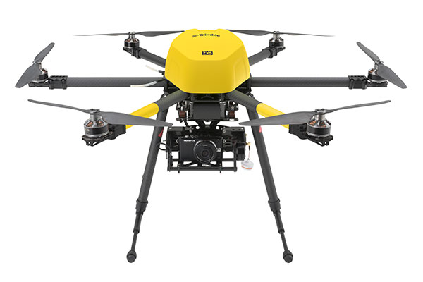
The Trimble ZX5 multirotor UAS.
The ZX5 Multirotor is built for everyday jobs where image capture from tight spaces is common. Its vertical takeoff and landing capabilities allow users to work in tight places and obstructed environments where fixed-wing solutions are less suitable. It requires no launcher, is easy to assemble and includes everything needed to capture high-quality geo-referenced photos for aerial mapping and inspection applications.
The ZX5 includes a 16-megapixel camera to capture high-quality aerial imagery, down to 1-mm ground sample distance. The ZX5 also can be equipped to capture live video imagery for civil infrastructure, utility and oil and gas pipeline inspections.
Data captured by the ZX5 can be imported into Trimble Business Center Photogrammetry Module software to create detailed ortho-photos, digital elevation models, point clouds, volume calculations and 3D models, all without requiring specialized photogrammetry knowledge or experience. It also integrates with Trimble’s Inpho UASMaster module for advanced photogrammetric processing.
In addition, the Trimble ZX5 has been granted a Section 333 exemption from the Federal Aviation Administration.
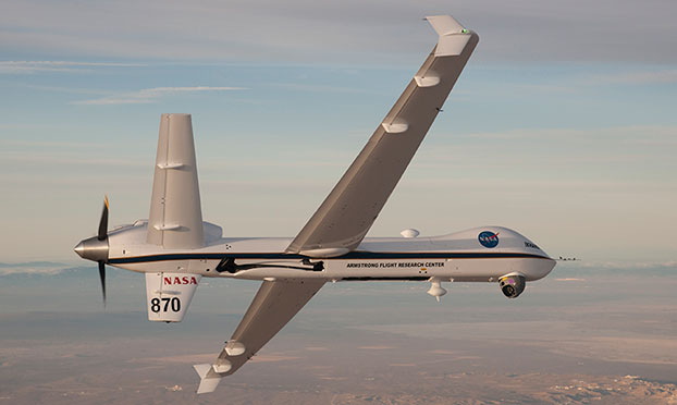
NASA’s Ikhana is being used to test a system that will allow uncrewed aircraft to fly routine operations within the National Airspace System. (Credit: NASA)
NASA plans to install a Locata network (LocataNet) as the core positioning technology for safety-critical unmanned aerial systems (UAS) research at its Langley Research Center in Hampton, Va., according to an announcement by Locata.
NASA Langley is tasked with performing rigorous and repeatable scientific evaluation of new UAS safety and technology concepts under development. The LocataNet will provide high-precision non-GPS-based positioning, navigation and timing (PNT) that is essential for this work. Known for its long history of aeronautics research, NASA Langley is a key center for UAS research and development. In June, one of Langley’s unmanned hexacopters (a drone with six rotors) delivered medical supplies to a clinic, the first such delivery by an unmanned drone.
Locata’s centimeter-accurate positioning will now assist NASA to develop and improve flight-critical technology systems that support air transportation safety, efficiency and performance. Langley’s extensive state-of-the-art facilities will be further enhanced with the installation of the LocataNet.
The NASA LocataNet is scheduled to be installed and commissioned before the end of 2015. Locata will supply the LocataLite Transmitters and Locata receivers required by NASA for the installation. Aviation-quality Locata antennas, developed by Cooper Antennas (UK) and previously used by the U.S. Air Force in its own military LocataNets, will also be installed. Locata engineers will support the physical installation, ongoing training and the future technical support required by NASA Langley for this world-first UAS deployment.
Locata Corporation has invented new terrestrial positioning networks which function as local, ground-based replicas of GPS. These networks can be thought of as “GPS hotspots,” according to the company. Locata has amassed 146 granted patents to date protecting these innovations, with many more patents in the works.
Locata is currently shipping commercial systems to demanding and professional end users such as the USAF, NASA, Leica Geosystems, and many others. Locata enables their integration partners to extend GPS-like positioning coverage to modern industrial, commercial, consumer and government applications in areas where GPS is erratic, jammed or unavailable.
“Locata is proud and delighted to have received an order for NASA’s first LocataNet. Globally significant installations like this prove Locata’s new technology is delivering unprecedented levels of performance to many important new applications,” said Nunzio Gambale, Locata CEO. “As our technology roll-out begins to gain pace, the exceptional value Locata brings to next-gen mobile apps has attracted interest from players all over the world. In fact, our list of relationships is now looking like a roster of the world’s crème-de-la-crème. I honestly can’t think of a better or more prestigious name than NASA to add to our growing partner list.”
“Our team is savoring the opportunity to work alongside NASA engineers and we’re excited that Locata will help advance the safety-critical performance of Unmanned Aerial Systems,” he continued. “Almost all future mobile devices or machines, be they on the road, in the air, on a mine site, in a port, in a warehouse, in your mobile phone, or part of the inevitable Internet of Things — all of them are critically dependent on pervasive, reliable, high-accuracy positioning. Locata is being leveraged into these next-gen systems because it’s clear that satellite-based solutions alone can no longer deliver what’s required. Soon, as we bring miniaturized Locata transmitters and receivers to market, our innovations will enable even greater advances in cutting-edge consumer, commercial, and government applications.”
NASA Testing Program. As part of its UAS research, NASA is testing a system that would make it possible for unmanned aircraft to fly routine operations in United States airspace. Through the agency’s Unmanned Aircraft Systems Integration in the National Airspace System (UAS-NAS) project, NASA, General Atomics Aeronautical Systems, Inc. (GA-ASI) and Honeywell International, Inc., are flying a series of tests which began on June 17 and will run through July at NASA’s Armstrong Flight Research Center in California.
“We are excited to continue our partnership with GA-ASI and Honeywell to collect flight test data that will aid in the development of standards necessary to safely integrate these aircraft into the National Airspace System,” said Laurie Grindle, UAS-NAS project manager at Armstrong.
This is the third series of tests that builds upon the success of similar experiments conducted late last year that demonstrated a proof-of-concept sense-and-avoid system. The tests engage the core air traffic infrastructure and supporting software components through a live and virtual environment to demonstrate how a remotely piloted aircraft interacts with air traffic controllers and other air traffic.
“This is the first time that we are flight testing all of the technology developments from the project at the same time,” Grindle said.
This series of tests is made up of two phases. The first is focused on validation of sensor, trajectory and other simulation models using live data. Some of the tests will be flown with an Ikhana aircraft, based at Armstrong, that has been equipped with an updated sense-and-avoid system, as well as other advanced software from Honeywell.
Other tests will involve an S-3B plane from NASA’s Glenn Research Center in Cleveland, serving as a high-speed piloted surrogate aircraft. Both tests will use other aircraft following scripted flight paths to intrude on the flight path the remotely-piloted craft is flying, prompting it to either issue an alert or maneuver out of the other aircraft’s path. These flights will also conduct the first full test of the traffic alert and collision avoidance system (TCAS II) on a remotely piloted aircraft.
During the June 17 test, which lasted a little more than five hours, the team accomplished 14 encounters using the Ikhana aircraft and a Honeywell-owned Beech C90 King Air acting as the intruder. A second test was flown the following day, with a total of 23 encounters. The project team plans to fly more than 200 encounters throughout the first phase of the test series.
“Our researchers and project engineers will be gathering a substantial amount of data to validate their pilot maneuver guidance and alerting logic that has previously been evaluated in simulations,” said Heather Maliska, Armstrong’s UAS-NAS deputy project manager.
The second phase of the third test series will begin in August and will include a T-34 plane equipped with a proof-of-concept control and non-payload communications system. It will evaluate how well the systems work together so that the aircraft pilots itself, interacts with air traffic controllers and remains well clear of other aircraft while executing its operational mission. The aircraft, which will have an onboard safety pilot, will fly an operationally representative mission in a virtual airspace sector complete with air traffic control and live and virtual traffic.
Topcon Positioning Group announces a worldwide distribution partnership with unmanned aerial system (UAS) provider Ascending Technologies. The agreement gives Topcon exclusivity for the global distribution of the AscTecFalcon 8 rotary-wing model, plus the GeoEXPERT and the InspectionPRO sensing and feature packages.
“We are excited to add the brand new Topcon Falcon 8, powered by Ascending Technologies, to our scope of aerial mapping solutions,” said Eduardo Falcon, executive vice president and general manager for the Topcon GeoPositioning Solutions Group. “By distributing both core target models on a worldwide level, Topcon can offer more end-users the flexibility and proven advances that these patented rotary-wing systems provide for survey, inspection and monitoring applications.” The Topcon-branded UAS includes the latest AscTecTrinity autopilot technology.
Based in Germany, Ascending Technologies is a developer and manufacturer of micro UAS for professional, civil and research use. “The AscTecFalcon 8 has been in series production since 2009 and still is the first choice UAS of world market leading inspection and surveying service providers,” said Jan Stumpf, one of the four CEOs and co-founder of Ascending Technologies.
“We are proud that our proven and advanced technology can now be easily accessed throughout the world. With the help of Topcon and its reseller network we can provide our high standards of support and customer service everywhere. This partnership gives us the freedom to continue the development of game changing technologies our customers need, while quickly extending our active fleet of reliable UAVs,” said Stumpf.
Progressive Technology Federal Systems Inc. (PTFS) has introduced Droneware, a geospatial content management system (GeoCMS) for unmanned aerial systems. Droneware facilitates the storage, discovery and dissemination of virtually any type of sensor data captured by a UAS or unmanned aerial vehicles.
PTFS is the provider of the Knowvation Enterprise Content Management System (ECMS) for users of geospatial data. PTFS unveiled the new system at the 2015 Esri User Conference being held July 20-24 in San Diego, Calif. PTFS will demonstrate Droneware GeoCMS in booth #N1332 at the San Diego Convention Center.
“Unmanned Aerial Systems capture large volumes of data that must be quickly organized, interrogated and disseminated immediately,” said Dan Quinn, PTFS vice president. “Droneware makes it easy to manage enormous archives of UAS data so the right image, video or other sensor data can be found and accessed instantly.”
A thin client/server-based solution requiring only a web connection, Droneware runs on a PC in the office or handheld device in the field enabling the user to interrogate local or remote UAS data storage anytime from anywhere. Droneware is built on the Knowvation ECMS technology, which commercial and government organizations use to manage raster and vector geospatial data as well as video, audio and text-based content across multiple large data archives.
The primary appeal of Droneware to UAS and UAV data users is its simple and intuitive search and browse capability for data discovery. Users can perform geospatial queries by typing a geographic name or word, entering latitude/longitude coordinates or preforming a visual search by drawing a rectangle on a map interface. Droneware performs the search on the entire archive regardless of data type or file format.
“Droneware is configured and ready for use in minutes for fast and effective support of any UAS data application,” Quinn said.
PTFS offers the option of deploying Droneware as the client’s repository of record in which all UAS content is ingested, stored, managed and searched inside the application. Droneware can be purchased on the Amazon Marketplace and deployed in various EC2 cloud instances for commercial use or for the hobbyist.
AWS Marketplace enables customers to compare options, read reviews, and quickly find the software they want. Visitors seeking Droneware in AWS Marketplace can purchase and launch Droneware with 1-Click deployment. Droneware is then available for consumption on an hourly or annual basis.