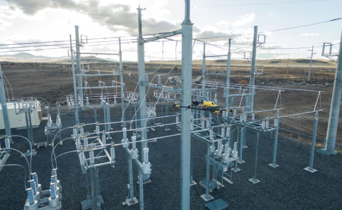
An electric cooperative that serves more than 33,000 member customers in Lakeside, Arizona — including the White Mountain Apache Tribe — is using an unmanned aerial system (UAS) to enhance the utility’s GIS effort, working with UAS specialist Skynetwest. Noah Ruiz started Skynetwest in 2015 to provide aerial photographic and videographic services, but seeing the potential of UAS he began making the pivot to high-value data retrieval.
Initial work for the Navopache Electric Cooperative (NEC) included an inspection of an area’s substations. Conducted on a day in which the winds were blowing at 20+ mph, with most other aircraft, the flight would have been extremely risky if not scrapped.
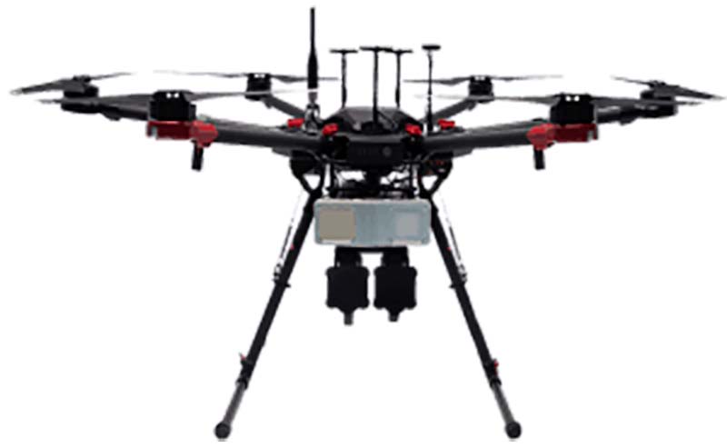
Skynetwest used an Intel Falcon 8+ Drone, Topcon Edition. Windspeed limits for the Falcon 8+ in GPS mode are set at 26 mph; in height mode that threshold is extended to windspeeds as high as 35 mph.
The Falcon 8+ has triple-redundancy inertial measurement units (IMUs), double-redundant compasses, dual-constellation GPS, eight propellers and two batteries. Built into the aircraft’s software is an algorithm that detects the electromagnetic frequencies coming off of power lines and tells the IMUs which one it wants to switch from, which GPS it wants to use, and which compass it wants to use.
The aircraft’s stability is key not only for power line work but also for items like inspection of oil and gas components. For inspection applications — close-up inspections to detect millimeter-sized damage, fine hairline cracks, leaks or heat power losses, for example — the Falcon 8+ payload consists of a Panasonic Lumix DMC-ZS50 camera for true-color RGB images and the FLIRTau 2 640 thermal imaging camera for infrared imaging. The hybrid RGB + 14-Bit RAW data inspection payload combines a near-infrared camera with a high-resolution digital camera mounted in parallel.
The mapping package Skynetwest uses includes a 36-megapixel RGB camera (Sony Alpha 7R) and delivers both orthophotos and 3D models in Topcon ContextCapture software, powered by Bentley Systems.
Upon completion of the substation project, using ContextCapture and Agisoft PhotoScan software, Skynetwest stitched together all of the images it had gathered to create a georeferenced 3D model of that substation. NEC is looking into building more 3D representations of the entire grid and ultimately hoping to build a complete 3D spatial record down to nuts and bolts — all with survey grade data.
The Federal Aviation Administration has added new airspace restrictions — effective July 11 — on unmanned aircraft systems (UAS) attempting to fly over national-security-sensitive locations.
The FAA has been cooperating with federal partners to address concerns about malicious drone operations by using the agency’s existing authority under Title 14 of the Code of Federal Regulations Section 99.7 (14 CFR § 99.7), Special Security Instructions, to establish UAS specific flight restrictions over select, national security sensitive locations.
The FAA’s Notice to Airmen (NOTAM), FDC 8/3277, defines these special security instructions. The FAA published a NOTAM, FDC 9/3332, which alerts UAS operators and others in the aviation community of this change and points to FDC 8/3277.
The additional 12 restricted locations requested by the U.S. Department of Defense are identified below.
Raven Rock Mountain Complex in Adams, PA
Lake City Army Ammunition Plant in Independence, MO
Pine Bluff Arsenal in White Hall, AR
Tooele Army Depot in Tooele, UT
Hawthorne Army Depot in Hawthorne, NV
Pueblo Chemical Depot in Pueblo, CO
Iowa Army Ammunition Plant in Middletown, IA
Watervliet Arsenal in Watervliet, NY
Blue Grass Army Depot in Richmond, KY
Letterkenny Army Depot in Chambersburg, PA
Rivanna Station in Charlottesville, VA
Maui Space Surveillance Site in Maui, HI
UAS operators, in particular, are urged to review the special security instructions prescribed by FDC 8/3277 and the important supporting information provided by the FAA’s UAS Data Delivery System (UDDS) website.
The UDDS website provides easy access to the text of FDC 8/3277 and other UAS-specific security NOTAMs; a current list of the airspace to which these special security instructions have been applied, supported by an interactive map and downloadable geospatial data; and other crucial details. A link to these restrictions is also included in the FAA’s B4UFLY mobile app.
The new UAS flight restrictions highlighted above and by FDC 9/3332 are pending until they become effective on 07/11/2019. UAS operators should keep in mind that access to the airspace identified by FDC 8/3277 and UDDS is strictly controlled.
Operators who violate these flight restrictions may be subject to enforcement action, including potential civil penalties and criminal charges.
The FAA is continuing to consider additional requests by eligible Federal security agencies for UAS-specific flight restrictions using the agency’s 14 CFR § 99.7 authority as they are received. The FAA will announce any future changes, including additional locations, as appropriate.
For further, broader information regarding flying drones in the National Airspace System, including frequently asked questions, please refer to the FAA’s UAS website.
Raytheon Company has signed a strategic agreement with AirMap, an airspace intelligence platform for drones, to collaborate on projects to safely integrate unmanned aerial systems (UAS) into the national airspace system. This will help unlock the positive economic and social benefits of expanded commercial drone operations, the companies said.
Unmanned air traffic control advances will unlock safe, efficient and scalable drone operations with a myriad of economic and social benefits.
“AirMap is ushering in a new era in drone aviation,” said Matt Gilligan, vice president of Raytheon’s Intelligence, Information and Services business. “Drones must safely operate in an already complex ecosystem, which is where our experience matters.”
The agreement combines the two companies’ expertise:
Raytheon’s Standard Terminal Automation Replacement System, or STARS, is used by air traffic controllers across the U.S. to provide safe and efficient aircraft spacing and sequencing guidance for more than 40,000 departing and arriving aircraft daily at both civilian and military airports.
AirMap is a global provider of airspace intelligence for UAS operations, with over 250,000 registered users. In 2018, U.S. registered commercial drone pilots used AirMap to request more than 45,000 automated authorizations to fly in controlled airspace.
“Raytheon technology has helped safely and effectively manage airspace in the most complex, dense controlled airspace in the world for decades,” said Ben Marcus, AirMap co-founder and chairman. “They are an ideal partner to join AirMap on the path toward enabling safe, efficient, and scalable drone operations in U.S. low-altitude airspace between 0 and 400 feet.”
The two companies are working toward an integrated demonstration that will showcase how AirMap’s unmanned aircraft traffic management platform can increase air traffic controllers’ awareness of potential conflict between drones and manned aircraft near airports to ensure overall safety of the airspace.
Welcome to Part 2 of our coverage of the mammoth AUVSI Xponential 2019 show in Chicago, which drew 8,000 attendees, featured 300+ speakers on its technical program, and furnished a temporary home for more than 800 exhibitors. It was “Everything Unmanned” and a challenge to cover. Last month we looked primarily at new vehicles. This month’s column focuses on sensors, capabilities and apps aboard those and other airborne drones — and even an anti-drone drone!
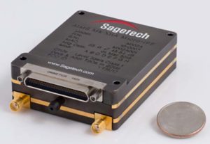
Sagetech: For UAVs to gain entry to the US National Airspace System (NAS) and to other controlled airspace all around the world, sense-and-avoid capability is paramount. Sagetech comes from the world of Mode-S transponders, with which the majority of piloted aircraft are equipped. These devices transmit aircraft identification and provide the moving IDs on air-traffic controller display monitors. In the military sector, Identification Friend or Foe (IFF) interrogator-transponders enable similarly equipped aircraft of NATO countries to determine which are friendly aircraft within their immediate airspace, and which are not.
The MX12B Mode 5 IFF with FAA-certified civil modes. (Photo: Sagetech)
Sagetech has just released a micro-mode 5 MX12B aviation transponder that enables small unmanned aircraft to interoperate within NATO airborne units. The transponders weigh around 10lb, so mil-spec UAVs operating in NATO airspace can now also carry this light-weight unit.
For civilian UAVs, GPS has been added to provide aircraft position outputs in Automatic Dependent Surveillance Broadcast (ADS–B) message format, allowing other aircraft and UAVs to receive a vehicle’s location. The Sagetech ADS-B transponder is small, certified to Federal Aviation Administration (FAA) standards (TSO C-166b) and is affordable. Boeing Scan-Eagle UAVs apparently already carry Sagetech transponder capability.
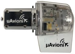
The tailBeacon ADS-B retrofit. (Photo: uAvionics)
uAvionix: Another avionics supplier has brought out certified ADS-B capable transponders, but with a novel way to add the required capability to general aviation (GA) aircraft, typically smaller private planes. The FAA has mandated that all aircraft should be fitted with ADS-B capability by January 1, 2020 in order to fly within controlled airspace, so uAvionix has simplified ADS-B retrofit for older GA aircraft.
All aircraft have wingtip and/or rear-tail beacon lights; this update replaces their existing beacon with a light which also includes ADS-B capability when paired with the aircraft transponder.
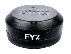
The FYXnav TSO CERTIFIED GPS navigation source. (Photo: uAvionics)
uAvionix also supplies a couple of GPS sensors for external mounting on UAVs: the FYXnav sensor is FAA-certified to TSO-C199 Traffic Awareness Beacon System Class B.
Sensefly released a new inspection application for their eBeeX UAV, specifically designed for solar farms. With a dual thermal/video sensor for data collection and data processing using application-specific Raptor Maps software, Sensefly claims to reduce the inspection time required for a 150MW solar farm to around 1 day, a 300-times improvement on ground inspection using a hand-held thermographic sensor.
Provided an inspection operation could support five 70-minute eBee-X flights during one day, the UAV could over-fly up to 161 acres of solar panels at an altitude of 138ft, gathering anomalies during each flight. This adds up to 150MW of solar panels over the 5 flights. Sensefly claims this to be twice as fast as with multi-rotor dones. The Raptor Maps software then generates an inspection report identifying each anomaly, using the eBee X’s video and thermal imagery to identify, classify, and localize the detected problems.
The Fortem DroneHunter intercept drone. (Photo: Fortem)
Fortem makes an anti-drone defense combining a radar detection system with a DroneHunter drone that attacks other UAVs, releasing an 80ft net to capture intruders. For those nefarious drones which are hardened against RF countermeasures, this system is also touted as capable of recovering the offending drone without damage, returning it to the operator in a net at the end of a tether. The DroneHunter flies autonomously on its intercept mission, carrying a compact radar system integrated with a ballistic net release system.
Septentrio continued promotion of its Mosaic chip-level GNSS at Xponential. The new chip uses the same proven core DSP with a new RF front-end and a new processor, working with more than 30 signals from the existing six GNSS constellations, and with L-band and satellite-based augmentation systems (SBAS).
The chip appears to be aimed at the high-precision market, replacing the AsteRx-m2 board level receiver family.
The chip runs Septentrio RTK algorithms, is quite small (1.29 x 1.29 x 0.15 in), is designed for high-volume surface mount manufacture, and comes with a set of popular interfaces. The chip is sampling now, with production planned for later this year.
NovAtel is growing, opening new offices in the US and needing more local real-estate to fit its headquarters in Calgary, Canada. The company is now part of Hexagon Positioning Intelligence (Hexagon PI), a partial re-branding that includes VERIPOS correction services and recently purchased AutonomousStuff, specializing in ground vehicles. Each organization still operates individually through its own brands. On the NovAtel booth, existing products were presented through a number of new applications, including those of the growing mil-spec products group.
Summary. While AUVSI Xponential was over in early May, the companies who were there have not rested. All are developing new approaches for UAVs and unmanned ground vehicles, sensor systems for even wider applications than seen in Chicago, and all manner of other added capabilities. This business only gets bigger and more innovative.
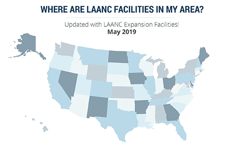
More than 100 control towers and airports have been added to the hundreds of Federal Aviation Administration (FAA) air traffic facilities and airports that currently use the Low Altitude Authorization and Capability (LAANC) system.
LAANC is a collaboration between the FAA and industry that directly supports the safe integration of unmanned aircraft systems (UAS) into the nation’s airspace.
LAANC expedites the time it takes for a drone pilot to receive authorization to fly under 400 feet in controlled airspace. By adding contract towers to the number of LAANC-enabled facilities, drone pilots will have access to more than 400 towers covering nearly 600 airports.
In less than two years, LAANC has provided fast access to controlled airspace for more than 100,000 flights, according to Matt Fanelli, director of strategy at Skyward.
Image: Skyward
“People have been asking the FAA to add more airports and today, 109 contract towers have now been added to LAANC.” Skyward has updated its 2019 LAANC Facilities Guide so that UAV pilots can easily reference airports near them that will be adding this service.
Contract towers are air traffic control towers that are staffed by employees of private companies rather than by FAA employees. LAANC provides air traffic professionals with visibility into where and when authorized drones are flying near airports and helps ensure that everyone can safely operate within the airspace.
The expansion to more than 100 contract towers means the FAA has further increased drone pilots’ access to controlled airspace safely and efficiently.
LAANC is used by commercial pilots who operate under the FAA’s small drone rule (PDF) (Part 107). The FAA is upgrading LAANC to allow recreational flyers to use the system and in the future, recreational flyers will be able to obtain authorization from the FAA to fly in controlled airspace.
For now, recreational flyers who want to operate in controlled airspace may only do so at fixed sites.
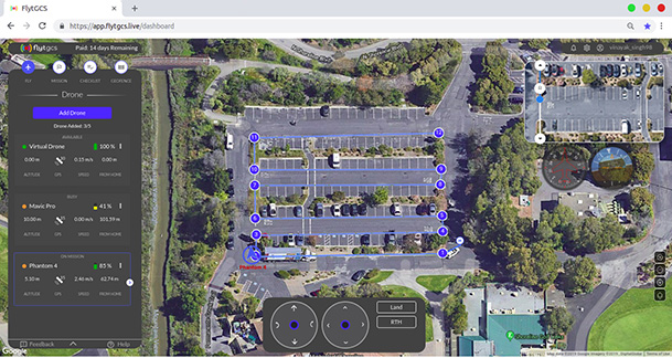
FlytBase Inc., an enterprise drone automation company, has launched of FlytGCS, a cloud-based remote drone operations solution, at AUVSI Xponential 2019.
FlytGCS is built for subject matter experts, drone operations managers and UAV operators who wish to automate, simplify and scale their missions. At its core is beyond-visual-line-of-sight (BVLOS) operations.
Photo: FlytBase
To support the execution of automated BVLOS missions, FlytGCS offers a wide range of features including connectivity and control over 4G/LTE/5G, live high-definition video feed, fleet management, unlimited missions and unlimited drone addition, remote gimbal control, pre-flight checklist and geofence, mission planner and cockpit view from a web dashboard.
FlytGCS is a hardware-agnostic solution that helps securely deploy industry-standard drones over the cloud, for BVLOS operations, using a mobile app (for DJI drones) or onboard SBCs (for Ardupilot and PX4 drones).
Add-ons such as precision landing, fleet management, pilot team management and drone-in-a-box make FlytGCS a powerful, affordable and scalable alternative to traditional, expensive, desktop-based GCS products, the company said.
According to FlytBase, UAVs will create significant business value as soon as drone fleets can fly BVLOS. Technologists, regulators, business executives and drone operators all expect the industry to progress towards remote, autonomous, cloud-based drone operations across geographies, sectors and use-cases.
Photo: FlytBase
“With FlytGCS, the power of autonomy is made available to drone operators, subject matter experts and service providers who can now seamlessly manage drones over 4G/5G networks, with best-in-class latency and live video quality,” said Nitin Gupta, FlytBase CEO. “As a SaaS product, this FlytBase offering helps our customers get started immediately, for free, and upgrade to the feature set that is best suited for their business needs. Operators have used FlytGCS in applications ranging from construction management and security/surveillance operations to emergency response and utility/asset inspections.”
Grand Sky Business and Aviation Park and Harris Corp. have joined forces to enable the country’s first and largest unmanned aerial system (UAS) airspace to support beyond visual line of sight (BVLOS) flight operations and UAS Traffic Management (UTM) research.
Stretching up to 100 miles, this BVLOS “super corridor” is the most technologically sophisticated UAS airspace supported by multiple and redundant systems for cooperative and non-cooperative surveillance.
These surveillance capabilities make possible a wide range of UAS BVLOS applications in precision farming, oil and gas, infrastructure inspection, public safety, package deliveries, and others.
“Customers of Grand Sky will have access to a truly unique UAS operational capability, in addition to better facilities, comprehensive airspace surveillance, and wide operational areas,” Grand Sky Development Co. President Thomas Swoyer Jr., said. “We all benefit from efficient and safe BVLOS flight operations and a larger corridor with proven FAA collaboration and flight authorizations.”
The surveillance system combines data feeds from a network of advanced sensors and towers. Two long-range primary radars located at Grand Forks Air Force Base and at Hillsboro, North Dakota, provide detection of non-cooperative aircraft.
The Federal Aviation Administration (FAA) secondary radars and ADS-B network in the region, as well as local Harris ADS-B Xtend sensors, add additional layers of visibility for cooperative aircrafts in the airspace.
Aviation-grade displays help pilots and electronic observers monitor the airspace environment over the BVLOS corridor and safely steer UAS from approaching manned aircraft.
The combination of best practices in aviation safety management, proven technologies and experience with BVLOS regulatory approvals will make it easy for users of the airspace to advance UAS technology commercialization and routine, efficient flight operations.
UAS operators can work with Grand Sky and Harris to develop, test, and refine a variety of complex BVLOS concepts of operations and secure waivers from the FAA for large-scale use.
A full range of UAS operations can be supported for all types and sizes of unmanned aerial vehicles along the BVLOS corridor including a variety of airspace classes and execution of diverse defense, civil and commercial applications.
“This is another first for Grand Sky and North Dakota in leading the UAS Industry,” Harris Vice President and General Manager of Commercial UAS Solutions George Kirov said. “The size and complexity of the airspace opened to UAS BVLOS operations is unmatched in the UAS industry. The sophistication of the Harris BVLOS system at Grand Sky is also unprecedented — linking Harris’ most advanced suite of surveillance and detect-and-avoid services with a variety of surveillance assets that, together, ensure the highest level of UAS aviation safety.”
This partnership lays the foundation for larger and more capable surveillance corridors to enable UAS “highways” across the state of North Dakota and in support of expanding the variety of commercial UAS operations across the United States.
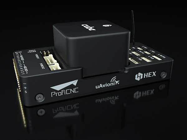
uAvionix has announced a partnership with autopilot maker CubePilot to integrate ADS-B IN receive capability into its carrier board.
uAvionix is the designer and manufacturer of communications, navigation and surveillance (CNS) equipment for unmanned and manned aircraft.
CubePilot is the designer and manufacturer of the “The Cube” autopilot (formerly known as Pixhawk) for unmanned aircraft systems (UAS).
The new carrier board, available in July, integrates uAvionix’s custom ADS-B silicon for 1090-MHz ADS-B reception for worldwide detect and avoid (DAA) functionality.
With this integration, UAS operators will be able to see nearby ADS-B OUT enabled aircraft on ARDUPILOT’s Mission Planner, providing the remote pilot in command (RPIC) with timely notification to take the necessary actions to remain well clear.
CubePilot, which uses the open-source ARDUPILOT platform, previously provided plug-and-play functionality for several uAvionix ADS-B IN and OUT products, including PingRX, Ping2020i and Ping1090i. Support for these products is retained in the new design, allowing for 978MHz ADS-B reception or integration of ADS-B OUT functionality.
“With this partnership, uAvionix furthers our goal of ensuring safety and common situational awareness between airspace users,” states Christian Ramsey, uAvionix president. “We believe that ADS-B IN functionality should be a requirement for every DAA system for UAS operations over people or beyond visual line of sight, and meeting that requirement should not be cost prohibitive.”
“The safe integration of UAS into the National airspace of any country needs to take a safety-first approach from all players,” said Philip Rowse, Hex/ProfiCNC (CubePilot) CTO. “By partnering with uAvionix and including the ADSB-in at practically no cost to the customer, we remove the cost barrier, adding safety to our customers’ UAS solutions.. We envisage this added situational awareness, and optional auto avoidance behavior will be an important step towards safely shared skies.”
Visit uAvionix at AUVSI Xponential in Chicago April 30-May 2 at Booth 4421 and CubePilot at Booth 1816.
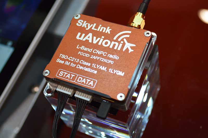
uAvionix, designer and manufacturer of communications, navigation, and surveillance (CNS) equipment for unmanned and manned aircraft, is testing its prototype of a command and non-payload control (CNPC) radio for unmanned aircraft systems (UAS) and urban air mobility vehicles.
Photo: Allison Barwacz
SkyLink is an L-band frequency-modulated CNPC radio ultimately intended for point-to-point or networked Beyond Visual Line of Sight (BVLOS) UAS operations. uAvionix has focused on minimizing size, weight, and power consumption (SWaP) while maximizing range and spectrum efficiency.
The current 50-gram 10-Watt prototype is testing successfully at ranges exceeding 40 miles at low altitude. uAvionix is testing under an experimental transmit license and approval from the Federal Communications Commission and Federal Aviation Administration, respectively.
Prior to founding uAvionix, CEO Paul Beard invented and brought to market the Spektrum digital spread spectrum radio control (RC) technology which moved the control link from 27 and 72 MHz bands to a high-bandwidth 2.4-GHz ISM band.
“Building high performance datalinks for airborne applications is insanely challenging,” said Beard. “Combining our ability to produce TSO certified equipment with the experience of developing and deploying millions of commercial products globally with Spektrum, we expect to bring affordable, scalable, and safe solutions to enable the UAS and UAM markets.”
The Federal Aviation Administration (FAA) has issued additional drone flight restrictions over U.S. federal prisons, military bases and Pearl Harbor, effective Feb. 26.
At the request of its federal security partners, the FAA is using its existing authority under Title 14 of the Code of Federal Regulations (14 CFR) § 99.7 — “Special Security Instructions” — to address concerns about drone operations over national security sensitive facilities by establishing temporary unmanned aircraft system (UAS) specific flight restrictions.
Information on the FAA Notice to Airmen (NOTAM), which defines these restrictions, and all of the currently covered locations, can be found at the FAA’s UAS Data Display System, which provides an interactive map, downloadable geospatial data, and other important details.
A link to the restrictions is also included in the FAA’s B4UFLY mobile app.
Additional, broader information regarding flying drones in the National Airspace System, including frequently asked questions, is available on the FAA’s UAS website.
In cooperation with Department of Justice (DOJ) and Department of Defense (DOD), the FAA is establishing additional restrictions on drone flights up to 400 feet within the lateral boundaries of the following federal facilities:
Federal Correctional Institution Allenwood Medium in Allenwood, PA
Federal Correctional Institution Beaumont Medium in Beaumont, TX
Federal Correctional Institution Butner Medium I in Butner, NC
Federal Correctional Institution Butner Medium II in Butner, NC
Federal Correctional Institution Coleman Medium near Sumterville, FL
Federal Correctional Institution Florence in Florence, CO
Federal Correctional Institution Forrest City Medium in Forrest City, AR
Federal Correctional Institution Hazelton near Bruceton Mills, WV
Federal Correctional Institution Lompoc in Lompoc, CA
Federal Correctional Institution Oakdale I in Oakdale, LA
Federal Correctional Institution Oakdale II in Oakdale, LA
Federal Correctional Institution Petersburg near Hopewell, VA
Federal Correctional Institution Pollock in Pollock, LA
Federal Correctional Institution Terre Haute in Terre Haute, IN
Federal Correctional Institution Tucson in Tucson, AZ
Federal Correctional Institution Victorville Medium I in Victorville, CA
Federal Correctional Institution Victorville Medium II in Victorville, CA
Federal Correctional Institution Yazoo City Medium in Yazoo City, MS
Federal Detention Center Honolulu in Honolulu, HI
Federal Detention Center Houston in Houston, TX
Federal Detention Center Miami in Miami, FL
Federal Detention Center Philadelphia in Philadelphia, PA
Federal Detention Center SeaTac near Seattle, WA
Federal Medical Center Carswell near Fort Worth, TX
Federal Medical Center Fort Worth in Fort Worth, TX
Federal Medical Center Rochester in Rochester, MN
Metropolitan Correctional Center Chicago in Chicago, IL
Metropolitan Correctional Center New York in New York City, NY
Metropolitan Correctional Center San Diego in San Diego, CA
Medical Center for Federal Prisoners Springfield in Springfield, MO
Metropolitan Detention Center Brooklyn in Brooklyn, NY
Metropolitan Detention Center Guaynabo in Guaynabo, PR
Metropolitan Detention Center Los Angeles in Los Angeles, CA
Fort Detrick in Frederick, MD
Fort Gordon near Augusta, GA
Fort Lee near Richmond, VA
Holston Army Ammunition Plant near Kingsport, TN
McAlester Army Ammunition Plant in McAlester, OK
Radford Army Ammunition Plant in Radford, VA
Joint Base McGuire near Trenton, NJ
Pearl Harbor Naval Defense Sea Area in Honolulu, HI
These changes, which have been highlighted by FAA NOTAM FDC [9/2586], are pending until they become effective on Feb. 26. Note that there are only a few exceptions that permit drone flights within these restrictions, and they must be coordinated with the individual facility or the FAA.
Operators who violate the flight restrictions may be subject to enforcement action, including potential civil penalties and criminal charges.
The FAA is continuing to consider additional requests by eligible federal security agencies for UAS-specific flight restrictions using the agency’s § 99.7 authority as they are received. Additional changes to these restrictions will be announced by the FAA as appropriate.
As part of ongoing global expansion, Microdrones has merged with Schübeler Technologies. Since its founding in 1997, Schübeler has built a global business by providing advanced fan propulsion jets and lightweight composite materials fabrication.
Offering a full product lineup of robust turbo fans, jets, compressors, pumps, electric motors, carbon fiber and aluminum composites, Schübeler products are designed to withstand extreme conditions and demanding field use. These components provide thrust power and lightweight durability to high-tech applications including UAVs, professional motorsports and heavy-duty outdoor equipment.
Microdrones, founded in 2005, has evolved from a manufacturer of commercial-grade unmanned VTOL aircraft to a provider of fully integrated systems for surveying, mapping, lidar and inspection applications. These systems are being put to use worldwide by professionals in the construction, mining, energy, agriculture and infrastructure trades.
“We make life easier for professionals by offering the full solution; it has proven to be a successful strategy,” said Microdrones President Vivien Heriard-Dubreuil. “Perfectly integrated drones, sensors, software, workflow, training and support is what the market needed. Welcoming the Schübeler team, talent and capabilities to Microdrones delivers new aviation technology and capabilities to our customers in the form of next generation unmanned aircraft.”
As the preferred provider of VTOL solutions to Trimble Dealers worldwide, Microdrones adds a global sales force and distribution network as well as technical centers and production sites spanning seven countries and three continents.
“Merging with Microdrones empowers us to develop and deliver systems where we can best support customers locally,” said Daniel Schübeler, founder and CEO of Schübeler Technologies. “This is a happy homecoming for me and the team that we’ve built over the past 20 years.”
Schübeler was an original founding partner in Microdrones and helped develop the pioneering technology that helped Microdrones gain global recognition for professional VTOL UAVs. He adds, “Both of these companies have enjoyed global growth and impressive technological advancements independently. Merging our talents and teams will yield amazing solutions in the years to come.”
“This is a strategic growth initiative,” explained Francois Gerner, SVP of Corporate Affairs at Microdrones. We are adding technology, IP, talent, strong leadership and investment capabilities that are complementary to both brands. This deal brings us to more than 150 highly skilled employees worldwide, which translates to better products, service and support.”
The merged companies will retain the Schübeler Technologies brand, which commands a niche’ audience of serious aeromodeling enthusiasts. Schübeler Technologies will continue to serve these markets as well as tackle large-scale custom R&D projects related to propulsion and materials.
Exploring a wide area in search of a hazardous substance emitting source or expansion of a fire front is an ideal UAV mission. Wildfire monitoring missions exemplify such a problem.
Most multi-UAV systems address problems related to search in an environment of interest. The UAVs cooperate and share data to obtain information within a certain aspect of the environment.
Regardless of the number of UAVs and size of the area of interest (AOI), cooperative systems deliver a perfectly up-to-date picture of the environment with coordination.
This paper investigates a coordination scheme for missions facing uncertainty about the periphery in the AOI. It takes into account the UAVs’ state, observations, the overall mission, and allocates each UAV to a specific task, enabling the multi-UAV system to act in a coordinated manner.
If a coordination algorithm for an environment with uncertainty is available, the overall system still leans on sensing capabilities. Even if the system uses the most advanced sensors, sometimes the environmental conditions are restrictive; that is, UAV sensors cannot reach far enough, and measured data can only be local and quantized data.
The goal of quantized estimation is to develop techniques to effectively reconstruct the data. The research approach relies on a technique for estimation of propagated boundary with quantized measurements and proposes a new class of one-dimensional estimator: the Greedy Uncertainty Suppression (GUS) strategy.
The monitoring application involves large numbers of possibly randomly distributed inexpensive sensors, with limited sensing and processing. The estimator incorporates observations gathered by multiple observers and uses the quantized kalman filter estimation to update the expected location and unobserved spreadrate.