Riegl now offers several new sensors and systems for airborne data gathering at various elevations.
At Intergeo 2018, the company unveiled sensors designed for low-flight altitudes, such as with UAVs. Riegl also introduced sensors designed for medium-flight altitudes used in large UAS/UAV/RPAS with higher payload capacity or in manned helicopters, and scanners and systems for data acquisition at high flight altitudes using manned fixed-wing aircraft.
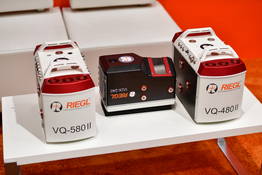
The Riegl VQ-480II and VQ-580 II on display at Intergeo 2018. (Photo: Riegl)
Medium altitude. The Riegl VQ-480 II (Mark 2) and VQ-580 II (Mark 2) are designed for airborne applications at mid-altitudes for use on both manned and unmanned aircraft. Based on the capabilities of their predecessors VQ-480 and VQ-580, their new, sophisticated designs lead the quality of the systems to a new standard of performance and user-friendliness.
Both offer a measurement rate of up to 1,250,000 measurement/second and a wide field of view of 75 degrees, suitable for corridor mapping, city modeling and applications in agriculture and forestry.
With approximately 10 kg of weight, they are ready for integration into helicopters as well as unmanned UAVs with a higher payload capacity, and are compatible with stabilized platforms and even small hatches.
The VQ-480 II and VQ-580 II are prepared for smooth GNSS/IMU integration, offer interfaces for up to five optional cameras, and are equipped with a removable storage card and an integrated SSD for data storage.
While the VQ-480 II works at a laser wavelength of 1550 nm, the VQ-580 II works at 1064 nm wavelength suited to measure on ice and snow.
Laser scanning. Riegl’s VUX series, focusing on unmanned laser scanning, has also been expanded. With the Riegl VUX-240, a new airborne lidar sensor with less than 4 kg weight and a sophisticated design offering 75-degree field of view is now ready to be integrated on both small manned and larger unmanned aircraft.
The high measurement rate of 1,500,000 measurements/second and a high scan speed of up to 400 lines per second are the basis for high scan efficiency, especially in applications like power lines, railway tracks, pipeline inspection or topography in open-cast mining. Interfaces for an optional GNSS/INS system integration and up to four optional cameras are further convincing key features of the new scanner.
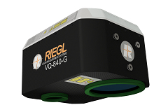
The Riegl VQ-840-G. (Photo: Riegl)
Bathymetry. For the bathymetric segment, the Riegl VQ-840-G has entered the marketplace. Designed for combined topographic and hydrographic surveys for use with large UAVs from lower flight altitudes, the scanner carries out laser range measurements for high-resolution surveying of underwater topography utilizing a green laser beam.
The scanner’s compact, lightweight and robust housing also can include an optional digital camera and an additional, fully integrated infrared laser rangefinder, and is compliant with typical hatches in aircrafts and with stabilized platforms.
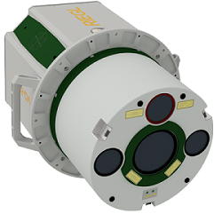
The Riegl VQ-880-GII. (Photo: Riegl)
Airborne laser scanning. The Riegl VQ-880-GII is a further improvement of the VQ-880-G topo-hydrographic airborne laser scanning system, offering online waveform processing and full waveform recording.
The improved setup includes a green laser channel, an integrated infrared laser channel, and an integrated dual camera system for RGB and IR. Typical applications include coastline and shallow water mapping, acquiring base data for flood prevention, and measurements for aggradation zones.
Also available are the VQ-780i airborne laser scanner and the VQ-1560i dual wavelength airborne mapping system.
Uplift adds commercially trained pilots and expands PrecisionHawk’s industry expertise and relationships in drone-based services for construction and facility management nationwide.
Uplift specializes in the delivery of turnkey inspection services for construction, building information management and real estate, and has provided drone services for national and global brands.
Its nationwide network of commercially trained drone pilots will join PrecisionHawk’s Droners.io network of more than 15,000 drone pilots. Suzanne El-Moursi, CEO of Uplift, will join PrecisionHawk’s executive leadership team managing the company’s construction line of business.
This is the fifth acquisition for PrecisionHawk in 2018. Early acquisitions include Droners.io and Airvid. In September, it purchased both Hazon Solutions and InspecTools which specialize in the delivery of inspection services and technology for the energy industry. Their integration with PrecisionHawk has created dynamic synergy, providing solutions that elevate airborne intelligence and strengthen the data value chain for the enterprise.
Similar to the energy space, the construction industry has experienced a rapid uptake in the adoption of commercial drone technology. Drones are now one of the leading innovative technologies that are transforming the construction process since they decrease the need for lengthy visual inspections, reduce planning time, improve worker safety and identify problems.
Uplift Data Partners was formed in 2015 as a fully integrated subsidiary of Clayco, one of the nation’s largest architecture, engineering, design-build and construction firms, with more than $2 billion in annual revenue.
Through the acquisition, Clayco will exclusively source its construction projects to PrecisionHawk, and will serve on PrecisionHawk’s Board of Advisors to support the growth of the company’s services and software in the construction industry.
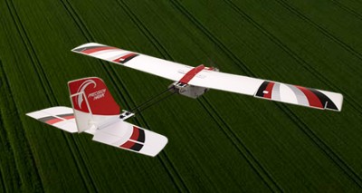
The PrecisionHawk UAV. (Photo: PrecisionHawk)
“PrecisionHawk is leading the commercial drone market by combining superior technology with deep expertise in the markets that they serve,” said Bob Clark, Clayco CEO. “Through this acquisition, Clayco customers gain access to a new level of technological sophistication for more scalable and robust operations, while continuing to benefit from Uplift’s deep understanding of the demanding nature of engineering and construction industry drone missions,.”
“This acquisition displays PrecisionHawk’s commitment to strengthening our technology and expertise in high-growth markets,” said Michael Chasen, PrecisionHawk CEO. “By combining PrecisionHawk’s leading-edge products and services with Uplift’s industry experience and training standards, our customers will receive best-in-class aerial data and analytics for complex construction and facility inspection projects through a simple and easy to procure process.”
“Our mission at Uplift is to support the modernization of the architecture, engineering and construction (AEC) industry by creating tools and training that improve the accessibility of drone services, thereby delivering true value to construction projects,” said Uplift CEO Suzanne El-Moursi. “The construction industry is uniquely rugged, yet defined by innovation and intelligence, and we are thrilled to join PrecisionHawk, a company that is both aligned to this mission and committed to the growth and expansion of the industry.”
A European Union-funded initiative has developed a low-cost positioning and navigation system for unmanned aerial systems (UAS).
Photo: European GNSS Agency
Using multiple antennas, the device is based on off-the-shelf components and advanced data-fusion algorithms. It fuses GNSS and inertial data to enable accurate and reliable navigation.
The EU-funded Horizon 2020 GLAD-2 project developed the system. The work involved in-depth analysis of algorithms, hardware and software redesign, exhaustive refinement and repeated in-field testing.
Researchers used low-cost GNSS receivers, together with advanced data fusion with an inertial measurement unit, and barometer data to enhance the attitude and position of UAS in harsh GNSS environments. The system also avoided the use of magnetometers, making it immune to magnetic fields, and removing the need for system calibration when the magnetic environment is modified.
Photo: European GNSS Agency
Engineers selected different GNSS antennas and measured their performance according to technical and economic criteria. A multi-antenna approach enabled UAS to take accurate headings without suffering the usual problems inherent to magnetometers.
“The inertial sensors provide an excellent dynamic response at very high data rates, while GNSS serves as an absolute reference to prevent drift. In addition, differential GNSS carrier phase measurements can be used to obtain great accuracy in orientation by using the multi-antenna configuration,” said project coordinator Esther López of Spanish technology company ACORDE.
GLAD-2 achieved the commercialization of the low-cost navigation system, culminating in the European Conformity (CE) certification mark following the corresponding certification process. The CE mark indicates conformity with health, safety and environmental protection standards for products sold within the European Economic area.
The result is a highly competitive product aimed at the low-cost sector of the navigation systems market. “Due to its flexibility, the system fulfils the needs of a wide range of users, not only in UAS, but also in terrestrial and maritime environments applications,” López said.
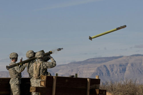
U.S. Army completes qualification testing for new Stinger missile proximity fuze.
The new proximity fuze enables the Stinger missile to destroy a wider array of battlefield threats such as enemy unmanned aircraft systems. (Photo: U.S. Army)
The U.S. Army has completed qualification testing for a new proximity fuze that significantly enhances the combat-proven Stinger missile produced by Raytheon Company.
The proximity fuze detonates the warhead if the missile passes within a certain radius of the target, creating a cloud of shrapnel that eliminates the target.
During testing at Eglin Air Force Base in Florida in April 2017, the upgraded weapon system scored a perfect 100 percent hit rate against a variety of targets. The missiles were shoulder- and vehicle-launched.
The new proximity fuze enables the lightweight, self-contained air defense system to destroy a wider array of battlefield threats such as enemy unmanned aircraft systems by detonating the missile’s warhead near the target, while maintaining its hit-to-kill capability.
“Equipped with a new proximity fuze, Stinger is an affordable, near-term and proven solution for countering emerging threats in the battlespace,” said Kim Ernzen, Raytheon Land Warfare Systems vice president. “Together with the Army, we are putting the most capable Stinger yet into the hands of our brave men and women on the battlefield.”
https://youtu.be/h75hxN-hcMQ
With qualification testing complete, the Army can move toward a near-term fielding under an Urgent Materiel Release. Plans call for the new proximity fuze to be integrated into Stinger missiles as part of a Service Life Extension Program to be conducted at the Army’s ammunition plant in McAlester, Oklahoma.
Combat proven, the Stinger missile has more than 270 fixed- and rotary-wing intercepts to its credit. It’s deployed in more than 18 nations and with all four U.S. military services. The weapon can be rapidly deployed by ground troops and on military platforms, and has been integrated for use on the Apache Attack Helicopter.
Special section, October 2018 GPS World. Cover photo: PrecisionHawk
If you blink, you might miss something! The examples here represent only a fraction of this booming field, but they show how diverse drone use has become. Interspersed among them, this article offers further insights on technology integration, the regulatory outlook and the economic future of this fast-moving industry.
By Tony Murfin, Contributing Editor, UAV & Professional OEM
Capturing where the drone industry has been this year and where it is headed in 2019 resembles trying to describe a Florida thunderstorm: how can there be so much rain so quickly, how long will it last, and what will the landscape look like afterwards? (I’m writing this during just such a deluge near Venice on the Gulf Coast.)
The UAV/UAS industry has grown at such an amazing rate, it’s almost impossible to count or describe all the applications that have become normal practice, not to mention the number of companies involved in either making drone platforms or supplying drone integrators with sensors: GNSS, inertial, lidar, cameras photographic, thermal, infrared, video and more.
From accident reporting to crop monitoring to infrastructure inspections, drones are, so to speak, on the rise. This year we have seen substantial increases in investments by equipment suppliers, continuing funding for military businesses, prototype systems for remotely identifying and even taking down drones, and vastly expanded use in mapping and survey.
As precision guidance, autonomous operations, high-definition geocoded images and high-volume data processing all improve, drone usage will continue to increase. OEM receiver manufacturers, sensor suppliers and data-handling companies play key roles in development, and stand to profit thereby.
The Delair Septentrio UX11 mapping UAV. (Image: Septentrio)
In particular, use of drones is growing in land management, construction, mining and farming. An open-pit mine operation can be supported through detailed drone inspection producing high-resolution images. Processed images and data enable keeping tabs on inventory, site changes over time, identifying best areas for further extraction, and monitoring and managing vehicle movement. These tasks required huge amounts of time in the past. Drone overflight and processing tools condense all the effort as well as producing enhanced results to enable faster and clearer decision-making.
Surveillance and reconnaissance are probably the biggest military drone applications. Carrying payloads that include color video cameras and infrared night vision cameras, more than 19,000 drones are now in the arsenal of the U.S. Army, Air Force, Marines and Special Ops, and more have gone to other nations’ militaries. Some fly at relatively low altitude, with limited range and powered by a single quiet electric motor; these drones have become essential in gathering forward-situation intelligence.
The following examples represent only a small part of the industry. I selected them here to show how diverse drone use has become. Interspersed among them, I’ll offer further observations on technology integration, the regulatory outlook and the economic future of this fast-moving industry. If you blink, you might miss something!
Accident Investigations
In the past, when police arrived at a serious traffic accident, investigators had to use tape measures and roller wheels to construct an accurate physical record of the incident. More recently, police have used laser measuring tools but this still entails time-consuming procedures and produces traffic back-ups. Now police departments have started to collect highly accurate aerial images of traffic incidents using drones, and it’s proving quicker and more efficient.
UAVs collect photos and videos, and software then stitches multiple high-resolution images together into a 2D or 3D map. With geolocation annotation provided by the drone, investigators can then take measurements directly from visual accident records.
Previously, an investigation could take up to three hours gathering information manually, but with a drone overflying and documenting an accident this might be reduced to around 45 minutes. This clearly saves time and money for the police as well as drivers who suffer shorter traffic delays. With an investment of about $15,000 in drone hardware and training, payback can happen pretty quickly.
Overall UAV Market Growth
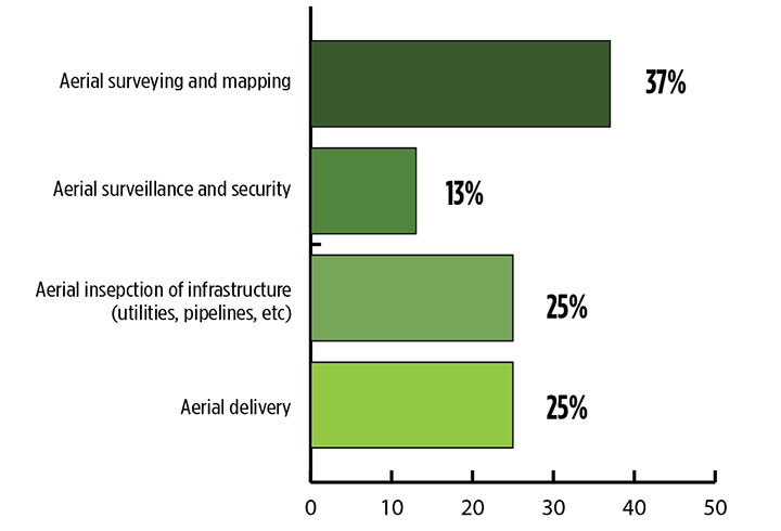
What is the killer app for drones? What professional UAV market sector will most powerfully drive adoption and influence new regulations for unmanned aerial vehicles? (Source: GPS World 2018 State of the GNSS Industry survey)
The drone logistics and transportation market was estimated to be valued at US $11.20 billion in 2022 and is projected to reach $29.06 billion by 2027, at a combined annual growth rate (CAGR) of 21.01%, according to India-based MarketsAndMarkets Research, in its May 2018 report.
The logistics and transportation market was defined to include warehousing, shipping, infrastructure, software, military, freight, and even passenger and ambulance drones. “The increasing use of unmanned aerial vehicles in civil and commercial applications for faster delivery of goods is one of the most significant factors expected to drive the growth of the drone logistics market,” stated the report.
The shipping segment is indeed projected to grow at the highest CAGR, as drones will see increasing use to transport a range of products from small packages to medical supplies and food. Venture capitalist investment in this market has been substantial as well as significant commitments by companies such as Amazon, Google, and Walmart in research and development to commercialize drone delivery services.
Couple that with another report from the same company report on the drone analytics market, valued at $1.17 billion in 2016 and projected to reach $5.41 billion by 2022, at a CAGR of 28.11% from 2017 to 2022. The drone analytics market was considered to encompass agriculture and forestry, construction, insurance, mining, utilities, telecommunications, oil and gas, and scientific research.
Both reports note that “The imposition of restrictions by various government agencies on the use of UAVs in civil and commercial applications is one of the major challenges faced by the drone logistics and transportation market.”
In February of this year, MarketsandMarkets estimated that the overall UAV market was valued at $18.14 billion in 2017 and projected to reach $52.3 billion by 2025, at a CAGR of 14.15%.
Agriculture
Results of a survey of 269 farmers by Munich Reinsurance America indicate that three quarters of all farmers in the U.S.— from those with less than 100 acres to those with more than 5,000 — have either begun to use drones for precision agriculture, and monitoring crops, livestock and soil conditions, or are thinking about using drones. Roughly half of these farmers contract out the work to drone service suppliers and most use drones either daily or more than once a week.
Sensor Integration
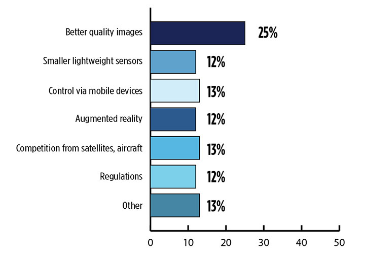
What is the biggest challenge for the UAV industry? (Source: GPS World 2018 State of the GNSS Industry survey)
As the size, weight and power (SWAP) and the accuracy of sensors continue to improve, drone use will continue increasing steadily. OEM receiver manufacturers, sensor suppliers and data-handling companies play key roles in this vital and ongoing development, and stand to profit thereby.
Making it all work is a combination of sensor payloads gathering inertial and GNSS location, stills and video, lidar, thermal and hyperspectral data; the secret sauce lies in how the data is processed and presented to users. All these areas show significant growth. The following are only a few key examples.
Lidar. Light detection and ranging (lidar) detects and measure the distance of an object or surface from an optical source, in this case a hovering or cruising UAV. GPS and inertial provide geo–referencing per each scan point.
Lidar has seen increasing application in surveying and engineering, GIS mapping, accident scene reconstruction, topographic and coastline mapping, digital elevation model and digital surface model generation, mining and quarries, gas and oil pipelines, railroads and other infrastructure. As hardware costs decline, software begins to play more and more of a major role, becoming a larger part of the solution in every way.
The M200 Snoopy series lidar package from LidarUSA is designed specifically for integration aboard the DJI M200 UAV. The laser scanning has a 100-meter maximum range, yielding 4-5 cm accuracy. It carries a tactical grade L1/L2 GPS/IMU unit and weighs 1.63 kg.
Inertial Miniaturization. UAVs are driving even further size-downs of other navigation sensors as well.
As just one example, the miniature μIMU from Inertial Sense incorporates a magnetometer, barometric pressure sensor, and L1 GPS (GNSS) receiver. Angular rate, linear acceleration, magnetic field, barometric altitude, and GPS location outputs are at 1 KHz with UTC time synchronization.
ADS-B.Aerobits in Poland has developed a high-speed, miniaturized (23.0 x 18.0 x 2.5mm & weighing 2 grams) Automatic Dependent Surveillance-Broadcast (ADS-B) module which provides detect-and-avoid for small UAVs. The module accepts external GNSS position inputs and has high speed on-chip processing which enables processing of thousands of ADS-B signals/second from other aircraft/drones. Aerobits claims a reception range of over 200 miles due to a high-sensitivity RF front-end. With FAA-mandated equipage coming for aircraft in 2020, this potentially offers a detect-and-avoid option for even small drones.
Regulatory Outlook
The Association for Unmanned Vehicle Systems International has been an industry voice for more than 40 years. AUVSI president Brian Wynne recently told Congress what needs to be done to fully integrate UAS into the National Airspace System — a critical step in further drone development and growth.
Initial regulations governing civil and commercial UAS operations are now in place. The FAA’s small UAS rule, known as Part 107, established a flexible, risk-based approach to regulating UAS and reduced many barriers to low-risk civil and commercial UAS operations. Since its enactment in 2016, however, demand for commercial UAS has exploded.
“As of March 2018,” Wynne stated, “more than 150,000 platforms have been registered for commercial use. The FAA expects more than 450,000 UAS to be flying for commercial purposes over the next five years.” That’s three times as many as today!
Waivers to Part 107 permit their holders to operate at night, as well as in certain restricted airspaces, beyond line of sight and over people. More than 1,700 operators across the U.S. have received these waivers.
Continued adoption of unmanned flight will require an expanded regulatory framework that extends the waiver provisions much more widely. There are many challenges to this, particularly security concerns. A key step will be “implementing a remote ID system that identifies any UAS flying in the airspace, in real time.” according to Wynne.
The FAA reauthorization bill recently passed by the House of Representatives calls for rulemaking concerning carriage of property, a necessary step for allowing UAS package deliveries — the next big thing.
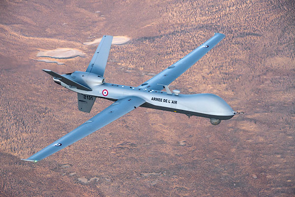
Military UAV Business Strong
French MQ-9 Reaper. (Photo: DoD press release/UAS Vision)
Military business remains a major source of revenue for the UAV/UAS industry, as demonstrated by the recent award of several contracts to various drone suppliers.
U.S. Naval Air Systems Command recently awarded Insitu a ~$54 million fixed-price contract for four production RQ-21A Blackjack unmanned aircraft systems and eight attrition air vehicles: seven for the Marine Corps and one for the government of Poland. The contract includes ground control stations, launch and recovery equipment, shipboard equipment kits as well as systems engineering and program management support.
U.S. Army Contracting Command recently awarded General Atomics Aeronautical System Inc. (GA-ASI) a Grey Eagle engineering support contract worth ~$11m. Work will be undertaken at the GA-ASI facilities in Poway, CA and will run through to Sept 30, 2019.
GA-ASI has also just won an FMS (Foreign Military Sales) contract worth $123 million for MQ-9 Reaper systems for France – deliveries are expected to be completed by May 2020. An FMS contract is normally how a foreign government procures U.S. government military equipment. The foreign government contracts with a U.S. agency, and the U.S. agency awards a back-to-back contract to the U.S. supplier. In this case, the U.S. contracting authority is the Air Force Life Cycle Management Center at Wright-Patterson Air Force Base.
The U.S. Missile Defense Agency has awarded General Atomics Electromagnetic Systems (GA-EMS), San Diego, California, a contract worth up to ~$134 million to develop, integrate, and flight test an advanced sensor into the MQ-9 UAV. The work will be performed in San Diego, California from August 2018 through October 2021 with realistic flight testing scenarios taking place both within the U.S. and elsewhere.
At the end of August, Boeing won the contest for the U.S. Navy’s unmanned refueling tanker with an $805 million contract award. The award covers the development and manufacturing of an initial four air vehicles. The future MQ-25 Stingray will be the first UAV to operate from U.S. aircraft carriers to refuel and extend the range of several combat aircraft.
L3 Technologies has won a U.S. Army $454M contract to build, deliver and support an electro-optical infrared laser designator for the RQ-7Bv2 tactical UAS. The drone mounted payload will help the Army manage battlespace situational awareness, increase UAS survivability and obtain imagery for target/threat detection.
Counter-UAS Systems
DroneShield out of Australia markets a drone detection and mitigation system, known for its DroneGun, a point-and-shoot device able to disrupt multiple RF frequency bands simultaneously (433MHz, 915MHz, 2.4GHz & 5.8GHz), taking out the communication link to a drone operator — and also GNSS signals when so equipped — up to 1km away.
The full DroneSentry detection system integrates a suite of sensors and countermeasures including radar, optical, RF listening, acoustic, thermal and an RF countermeasure transmitter with greater power/range than the portable DroneGun.
Survey and Mapping
SenseFly recently completed work on a three-year construction project in Northern Ireland to build the new A6 highway. A senseFly eBee Plus drone provided detailed aerial coverage and minimize interruptions with road traffic and ongoing quarry operations.
Adopting an integrated aerial approach enabled the construction contractor to quickly obtain detailed, accurate, professional-grade data, and has helped save time and resources. Reducing the time required in the field and proximity to dangerous quarry sites optimized the mapping task
High-Precision Survey Drone. The TRIUMPH-F1 UAV is built around the JAVAD GNSS TRIUMPH-1M receiver, the company’s high-precision geodetic GNSS receiver with 864 channels to track all current and future GNSS signals.
When used on the ground, the TRIUMPH-F1 can function as a TRIUMPH-1M base or rover. The four motor arms (for eight motors) are detachable. Four screw inserts in the bottom to attach the TRIUMPH-F1 to a pole mount for field use.
The TRIUMPH-F1 features user-friendly mission programming. The four lithium polymer batteries that power the eight propeller motors, arranged in a stacked quad formation.
The TRIUMPH-F1 also has two micro-SD slots for image storage, a SIM card slot, a USB connector for uploading flight plans and downloading collected images, and indicators for satellite tracking and communications. Other indicators are dedicated to flight status and gyro.
Vertical Landing.WingtraOne’s vertical landing technology enables touchdown in confined areas as small as 2 m x 2 m like boats or forest lanes. Combined with a flight range of up to 50 km, this makes large-coverage mapping missions feasible
The vertical-take-off-and landing (VTOL) drone WingtraOne is designed to safeguard its valuable sensors and eliminate wear and tear of the equipment. Instead of broken wings or damaged cameras from belly landings and parachute touchdowns, the WingtraOne lands gently. During the vertical descent, laser sensor data enables the WingtraOne to sense the ground and land safely even on rocky or hilly hilly terrain.
In case of a changing landing environment like a drifting boat or recently parked cars, the landing spot can be adjusted easily.
The WingtraOne works truly autonomously during its entire mission, including take-off and landing. Instead of catapult or hand launches that can cause injuries or damage equipment, the WingtraOne takes off vertically without any human interaction.
Shipping and Logistics
Matternet, based in Switzerland, is testing deliveries using drones under a 3-year program run by the North Carolina Department of Transportation. The NC program is one of 10 authorized by the FAA to evaluate the commercial use of drones.
The objective is to transport small items like blood samples, but initially vials of water will take the ride from a medical office building before landing on a hospital roof. In March, the company was authorized to operate drones over populated areas in Switzerland, carrying samples to hospitals in Lugano.
Items can be securely deposited into the drone station for pick up or retrieved following delivery. A smartphone application is used to authorize pick up and delivery. The item is then scanned for pick up, the station automatically installs the item into the drone for transport, the drone then departs for the assigned destination and on arrival, scanning is required to retrieve the delivered item at the other end.
Conclusion
These examples just skim the surface of an exploding industry which just keeps on keeping on, constantly developing new solutions and applications. High-altitude pseudo satellite drones, drone delivery of goods within minutes of placing an internet order, automated drone facility inspections, power via wireless to keep drones airborne, parachute safety systems for drones….the list goes on and on.
Clearly the UAV/UAS industry has only begun its journey. There are many unexpected places we can look forward to it visiting in coming months and years.
The inaugural European Drone Summit will be taking place Oct. 15 in Frankfurt, Germany.
According to event sponsor UAV DACH e.V., the conference will give operators, manufacturers and public authority representatives the chance to gather and discuss the potential modes of operation and applications that are opening up for professional drone service providers and companies in light of the unmanned aircraft industry’s new European general aviation regulation.
Keynote speakers at the event will include Peter van Blyenburgh, UVSI; Max Scheck, Vereinigung Cockpit; Jules Kneepkens, EASA a.D.; Martin Brandenburg, DJI; Andreas Lamprecht, AIRMAP; and Jörg Seebach, DeDrone. The Intel Drone Group’s Anil Nanduri will also present a keynote speech.
“We are delighted that high-ranking experts from different companies, some of whom are even competitors, have accepted our invitation to come on board,” said Michael Wieland from UAV DACH e.V. “Global players’ first-hand experience and solutions offer added value to everyone taking part.”
The goal of the European Drone Summit is to channel ideas and decisions relating to unmanned aircraft systems (UAS) in order to highlight how unmanned aerial vehicle technology can be used now and in the future by representatives of various sectors, organizers said. The summit will take place at the same time as Intergeo, which will take place Oct. 16-18.
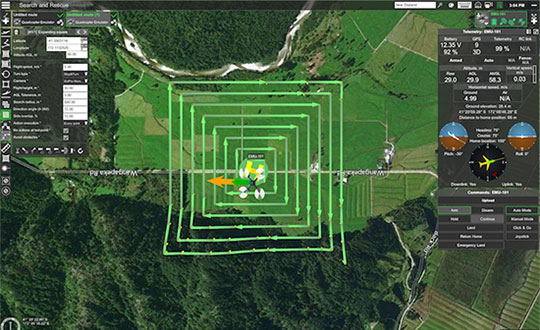
UgCS, a provider of mission planning software for unmanned aircraft systems (UAS), and public safety and disaster response UAS expert Airborne Response have developed a comprehensive search capability for drones that will allow remote pilots to more effectively conduct search-and-rescue operations using the UgCS platform.
The software enhancements will provide users with customizable search patterns such as the “expanding square” and “creeping line” that can be easily deployed in emergency and non-emergency situations.
Based on the flight altitude input by the operator, the UgCS software will automatically calculate key variables such as the course heading and track spacing necessary to provide the prescribed coverage area for a search target.
Tom “Oaty” Oatmeyer is an air rescue expert with 28 years of experience piloting helicopters for both the U.S. Air Force and the Miami-Dade Fire Rescue department. As an aircraft commander, Oatmeyer is credited with saving more than 150 lives during emergency and disaster response operations.
Oatmeyer worked directly with the UgCS development team to bring the new features to fruition.
“As first responders, we are trained to develop an emergency search plan using time-tested and proven tactics,” said Oatmeyer, chief pilot, Airborne Response. “The new enhancements to the UgCS mission planning software will allow remote pilots at every skill level to quickly plan and implement a professional search mission with a UAS.”
Airborne Response and UgCS will be hosting a joint web conference on Thursday, Aug. 16, at 2 p.m. ET to officially unveil the new search features of the UgCS mission planning software. Register here.
Also, Airborne Response and UgCS have reached an agreement for Airborne Response to offer the UgCS mission planning software and associated training to public safety and emergency response professionals throughout the U.S.
“When lives are on the line, every second counts,” Oatmeyer said. “UgCS now represents another valuable link in the UAS technology chain to enhance the public safety mission.”
“The new UgCS search feature is designed to make searching for a target with a drone as simple and reliable as possible,” said Janis Kuze, sales director at SPH Engineering. “We look forward to continue working with the Airborne Response team to further enhance the software capabilities and implement additional search pattern features.”
NDCOE’s mission is to save lives and reduce air hazards from drone incursions by empowering a shared safety vision with the the U.S. Federal Aviation Administration’s (FAA’s) integration of drones into the commercial air traffic system.
Located in Las Vegas, with facilities donated by technology infrastructure company Switch, NDCOE will provide safety incursion research data, drone technology best practices and educational materials.
The new center will conduct public workshops that promote and protect the public’s safety and privacy in an open and ethical manner.
Over the last decade, UAS, more commonly referred to as drones, have experienced an unprecedented boom within aviation. Coinciding with the increase in popularity, incidents involving drones in tourist areas, as well as risks to larger manned aircraft are on the rise and present high-liability risks to property owners.
Safe and successful UAS operations rely on quality training, end user education and maximizing public safety processes. To protect and educate residents and visitors, the center seeks to protect against drone users who pose a public safety hazard due to inexperience or malicious drone operations. Such hazards include drones hitting people or that have the potential to cause an airline disaster, and drone operations that violate safety, privacy or drone laws near high-traffic public places, at airports, near military bases or near critical infrastructure.
NDCOE will also advance drone surveillance, detect and avoid (remote sensing), wildland firefighting, gas-leak detection, and time-sensitive medical delivery technologies for life-saving medical equipment and organs.
“In addition to fostering major advances in UAS technology with testing partners like the FAA, NASA and Switch, Nevada is also home to the most registered drone users in the nation in Las Vegas,” said Paul Anderson, executive director of the Nevada Governor’s Office of Economic Development. “This dynamic makes such a program as the Nevada Drone Center of Excellence for Public Safety a natural step as drones increasingly become a bigger part of our daily lives.”
In a recent state-wide Nevada Drone Industry survey by the University of Nevada, Las Vegas (UNLV) and NIAS, the NDCOE received support to open the first center of its kind in the U.S. In the survey, almost 80% of respondents were concerned about a recreational drone hitting an airline and causing an airline disaster, and almost 90% were concerned about aerial drones illegally penetrating FAA airspace without authorization at outdoor events such as sports stadium, concert or at large events.
“We are taking an aggressive approach toward solving the complex UAS Industry challenge of mitigating drone incursions into the National Airspace System — one of the toughest FAA challenges today,” said Chris Walach, senior director, NIAS and the FAA-designated Nevada UAS Test Site. “What we are doing in Nevada will be of immense value to the DOT, FAA, DHS, DOJ, commercial airlines, visitor venues, and the UAS Industry. This new center will help advance infrastructure protections, drone detection innovations, enhance air safety, and expand air commerce in Nevada.”
NIAS and the FAA-designated Nevada Unmanned Aviation Test Site lead the growth of the Nevada UAS industry through business teaming relationships, collaborating with primary research institutions on UAS research and development, and enhancing the Nevada UAS Industry knowledge base to attract new and permanent business and create jobs in the State of Nevada.
A team of five volunteers armed with drones, advanced sensor systems and GIS technologies joined the response effort at Kilauea Volcano Lower East Rift Zone to assist in tracking and predicting the ongoing volcanic eruption.
Using small unmanned aerial systems (sUAS) together with air-quality sensors, advanced imaging tools and Esri’s spatial analytics and mapping, the team from the Center for Robot-Assisted Search and Rescue (CRASAR) provided real-time aerial views of the eruption.
The CRASAR team identified a new fissure not visible from the ground, projected the lava flow rate during the night when manned helicopters were not allowed to fly, and provided ongoing data collection from new thermal sensors technology.
The CRASAR response marks the first known use of sUAS for emergency response to a volcanic eruption and first known use of sUAS for sampling air quality. The CRASAR team provided Hilo Fire Department and the Civil Defense with live streaming of video from the sUAS over the new FirstNet cellular network.
“This latest CRASAR mission is another example of dedicated volunteers working together with private sector partners to deploy technology to save lives and property when disaster strikes,” said CRASAR Director and disaster robotics expert Robin Murphy. “With support from technology partners like Esri, Hangar Technologies, RemoteGeo and RMUS, we are able to both respond to active disasters but also demonstrate to the first responder community best practices and benefits of engaging robots and other technologies in disaster response.”
CRASAR supported tactical response operations at the Leilani, Hawaii, eruption event May 14-19, supplementing the University of Hawaii Hilo’s (UHH) sUAS capabilities and allowing UHH sUAS operators to focus on geographical and volcanology.
During the six-day Leilani deployment, the CRASAR team flew 44 sUAS flights, including 16 at night, using DJI 200, 210, Inspire, and Mavic Pro drones.
Esri’s Drone2Map for ArcGIS together with Hangar’s Enterprise Platform for 360-degree imaging enabled rapid 360-imaging for situational awareness.
Video and data were shared with local first responders using FirstNet, the first high-speed, nationwide wireless broadband network dedicated to public safety.
The CRASAR response team included sUAS pilots Justin Adams of Constellation Consulting Group, David Merrick and Laura Hart of Florida State University Center for Disaster Risk Policy, Jon McBride of Rocky Mountain Unmanned Systems, and Robin Murphy of Texas A&M University. Funding was provided in part through research grants from an insurance partner and the National Science Foundation.
“This eruption is especially impactful because of its location,” said Esri’s Public Safety Lead, Ryan Lanclos. “That makes the CRASAR’s use of drones and mapping technologies, and the near real-time situational awareness it provides of people, homes, businesses and infrastructure during this disaster, a resource first responders will be able to turn to time and again.”
CRASAR’s deployment to Hawaii marked a number of firsts for technology applied to disaster response. To interact with the same GIS mapping and imaging technologies responders used on the scene at Kilauea Volcano Lower East Rift Zone, visit this page.
The Federal Aviation Administration (FAA) has established temporary unmanned aircraft system (UAS) flight restrictions over federal penitentiaries and U.S. Coast Guard bases.
The restrictions, which take place June 20, are for drone flights up to 400 feet within the lateral boundaries of the facilities.
The restrictions came at the request of federal security partners the Department of Justice (DOJ) and Department of Homeland Security (DHS).
The FAA is using its existing authority under Title 14 of the Code of Federal Regulations (14 CFR) § 99.7 — “Special Security Instructions” — to address concerns about drone operations over these facilities,” the agency stated.
Information on the FAA Notice to Airmen (NOTAM), which defines these restrictions, and the covered locations, can be found on the FAA’s UAS website. Broader information regarding flying drones in the National Airspace System, including frequently asked questions, is also on the FAA website.
An interactive map, downloadable geospatial data and other important details can be found here.
A link to the restrictions is also included in the FAA’s B4UFLY mobile app.
This is the first time the FAA has placed specific flight restrictions for unmanned aircraft over Federal Bureau of Prisons and Coast Guard facilities. The FAA has placed similar flight restrictions over military installations that remain in place, as well as over 10 Department of Interior facilities and seven Department of Energy facilities.
Operators who violate the flight restrictions may be subject to enforcement action, including potential civil penalties and criminal charges.
There are a few exceptions that permit drone flights, which must be coordinated with the individual facility or the FAA.
The FAA is considering additional requests by eligible federal security agencies for UAS-specific flight restrictions using the agency’s §99.7 authority as they are received. Additional changes to these restrictions will be announced by the FAA as appropriate.
The following facilities will have the new restrictions:
United States Penitentiaries (USP)
USP Tucson near Tucson, AZ
USP Atwater near Atwater, CA
USP Victorville near Victorville, CA
USP Florence High near Florence, CO
USP Florence ADMAX near Florence, CO
USP Coleman I near Sumterville, FL
USP Coleman II near Sumterville, FL
USP Marion near Marion, IL
USP Terre Haute near Terre Haute, IN
USP Big Sandy near Inez, KY
USP McCreary near Pine Knot, KY
USP Pollock near Pollock, LA
USP Yazoo City near Yazoo City, MS
USP Allenwood near Allenwood, PA
USP Canaan near Waymart, PA
USP Lewisburg near Lewisburg, PA
USP Beaumont near Beaumont, TX
USP Lee near Pennington Gap, VA
USP Hazelton near Bruceton Mills, WV
United States Coast Guard (USCG) Bases
USCG Baltimore Yard, MD
USCG Base Boston, MA
USCG Base Alameda, CA
USCG Base Los Angeles/Long Beach (LALB), CA
USCG Base Elizabeth City, NC
USCG Base Kodiak, AK
USCG Base Miami, FL
USCG Base Portsmouth, VA
USCG Base Seattle, WA
USCG Operations System Center (OSC) near Martinsburg, WV
In the spring of 2017, the U.S. Marine Corps Warfighting Laboratory (MCWL) — via the Defense Department’s Defense Innovation Unit Experimental (DIUx) — engaged in a one-year prototype contract with Sensofusion to develop a ground-based mobile counter-UAS solution stemming from Sensofusion’s pre-existing core product Airfence.
Sensofusion acted as lead integrator and further advanced Airfence to integrate radar and optics systems on board vehicles enabling all systems to work in unison, with Airfence being the core counter-UAS solution by means of RF detection and transmission.
The DIUx project has been active for more than 12 months, growing and expanding since its late March 2017 launch.
Airfence is now fully ruggedized, meeting IP67 ruggedization requirements. Furthermore, Airfence has outperformed all tests for range of detection and counterattack capabilities and has also greatly increased the number of drones within its library it can detect, track and defeat yielding zero false positives, Sensofusion said. The system has outperformed range testing at the Marine Corps Base in Quantico, Virginia.
In addition, Airfence exceeded expectations against a large variety of small UAVs — including fixed wings and rotorcrafts — while Marines operated the technology under extreme weather conditions in Arizona at Yuma Proving Grounds. YPG is the largest U.S. military installation in the world and has been a key site for testing military equipment since World War II.
Through its work with the U.S. Marine Corps, Sensofusion has brought its system to a single sensor solution, which is beneficial for tactical use in a mobile convoy scenario.
Airfence also can be used for fixed installations when protecting areas such as military bases, airports, prisons, oil refineries and pipelines, nuclear power plants, power plants, government buildings and border walls.
Sensofusion has made major leaps in its ability to detect and defeat rogue drones by means of protocol demodulation and manipulation.
“Our work in the past year with the Marines enables us to meet production readiness with our flagship counter-UAS solution, AIRFENCE, and are now prepping for production with the Departments of Defense and Homeland Security,” said Sensofusion Vice President Kaveh Mahdavi. “We’re now at a point where DoD, DHS — really, any government organization — can order our standardized counter-UAS platform, Airfence, in large quantities. This is a significant advancement within our developing drone defense industry and will act as the benchmark for all future solutions.”
Extension to Sensofusion-U.S. DoD contract signed. As Sensofusion ramps up production for AIRFENCE across government agencies in America, it continues to align with MCWL, signing a one-year extension to the agreement with the DoD to innovate and implement new capabilities within signal intelligence.
DroneUp is collaborating with industry leaders and government officials to promote the desired outcomes of the Federal Aviation Administration (FAA), public safety personnel, and the unmanned systems community by announcing the Responsible Community Pilot (RCP) program.
DroneUp is a drone pilot community focused on safer skies through continuous education and sense of purpose. The announcement was made at the AUVSI Xponential show being held this week in Denver.
The mass proliferation of small unmanned aerial systems (sUAS), specifically those operated by non-commercial pilots, has created nearly unparalleled policy, safety and legislative issues.
To remove confusion and help increase resources available to all pilots, DroneUp is partnering with the International Association of Community Drone Pilots (IACDP) to provide tools and resources to meet the real objectives of improving airspace safety.
By providing free access to a community-based set of guidelines and programming, the RCP program engages drone pilots through training, certification, idea-sharing and community.
DroneUp provides the means and connections with the community to help pilots operate in the national airspace. Some of those free tools include:
Continually updated online courses and exams that improve regulation awareness
Mission-driven experiential exercises that improve piloting skills
An online community for questions and discussion
Mobile apps that verify where it is safe to fly and active advisories nearby
Comprehensive Standards of Conduct
Detailed Safety Guidelines
Advocacy on behalf of the community
“Our efforts to build this community through training and a sense of purpose are having dramatic positive effects on ensuring air safety,” said Tom Walker, Founder and CEO, DroneUp. “We are dedicated to not only continuing our efforts, but to sharing collected data that will prove invaluable to officials as they draft future policies.”
In advocating for both commercial and non-commercial use of small unmanned aircraft systems, IACDP represents commercial, recreational, military and public safety pilots.
“IACDP is motivated by a desire to make a positive impact on the industry,” said IACDP President John Evans. “We are still growing and expanding our training, certification, and advocacy resources. We see organizations like DroneUp as valuable strategic partners for our mission.”
To date, more than 20,000 non-commercial sUAS pilots are active members of DroneUp’s RCP community. Through affiliations with its non-profit partners, this number is expected to increase to more than 100,000 sUAS pilots over the next six months.
Membership in DroneUp’s RCP program requires successful annual completion of the RCP training and examination online.
Upon completion of the certification, RCP participants will receive a certificate with a unique ID number, an RCP badge in DroneUp’s mobile app; they also may request a personalized RCP ID Badge.