Photo: Philipp Berezhnoy/iStock / Getty Images Plus/Getty Images
According to a new research report, “GNSS Simulators Market by Component Type (Single Channel and Multichannel), GNSS Receiver (GPS, Galileo, GLONASS and BeiDou), Application (Vehicle Assistance Systems, Location-based Services and Mapping), Vertical, and Region — Global Forecast to 2025,” the market is estimated to grow from $106 million in 2020 to $165 million by 2025, at a compound annual growth rate (CAGR) of 9.3% during the forecast period.
Factors such as rapid penetration of consumer internet of things, the contribution of 5G in enabling ubiquitous connectivity and increasing use of wearable devices utilizing location information are expected to drive the adoption of the GNSS simulators hardware, software and services, the MarketsandMarkets report said.
Market segments
The report stressed several key points in regard to the hardware segment, automotive vertical segment and GPS segment.
The GNSS simulators market, by component, is segmented into hardware, software and services. Of these three, the hardware segment is expected to account for a larger market size in the coming years in the GNSS simulators market as it enables signal simulations and plays a key role in the simulation process.
The GNSS simulators market, by vertical, is segmented into military and defense, automotive, consumer electronics, aerospace, marine and other verticals (agriculture, construction, and rail and road). According to the report, the automotive vertical segment is expected to hold a higher CAGR during the forecast period in the GNSS simulators market.
“GNSS offers a cost-effective and accurate way of determining position in real-time,” the report said. “Ride-sharing apps, such as Uber and Lyft, car-sharing, usage-based insurance apps, dynamic toll charging and parking apps all depend on the real-time location of the car. GNSS offers sufficient accuracy for all these apps by providing location coordinates leading to its adoption in the automotive vertical.”
Next, GNSS receivers are segmented into GPS, GLONASS, Galileo, BeiDou and others, with the others comprised of NavIC and QZSS receivers. The satellite tracking service provided by GPS is useful in various commercial and personal applications. The increasing commercial application of GPS vehicle tracking system for taxi companies and cab services is contributing to the rising adoption of GPS location services. It makes the navigation easier by providing relevant details, such as distance and shortest route to the desired location, the report said.
Market size and location
North America is expected to have the largest market size during the forecast period, with the key factor favoring the growth of the GNSS simulators market in North America being the increase in technological advancements coupled with the rise in government support for the adoption of UAVs. The increasing number of players across different regions is also further expected to drive the GNSS simulators market globally, the report said.
In addition, Asia-Pacific is projected to grow at the highest CAGR during the forecast period, as it has witnessed considerable developments and adoption of solutions across the region. According to the report, Asia-Pacific has a large potential for GNSS and space-enabled applications, and it has a wide consumer base due to its booming economies accompanied by an increasing share of local R&D and technology innovations.
Major players
Major vendors in the global GNSS simulators market include Spirent Communications, Rohde & Schwarz, VIAVI Solutions, Hexagon, Keysight Technologies, u-blox, Orolia, Cast Navigation, Accord Software and System, IFEN, Racelogic, Syntony GNSS, Teleorbit, iP-Solutions, Pendulum Instruments, Saluki Technology, Shanghai Huace Navigation Technology, Averna, GMV NSL, Brandywine Communications, Jackson Labs Technologies, Hunan Shuangln Electronic Technology, Work Microwave, Qascom and M3 Systems.
A roundup of recent products in the GNSS and inertial positioning industry from the January 2021 issue of GPS World magazine.
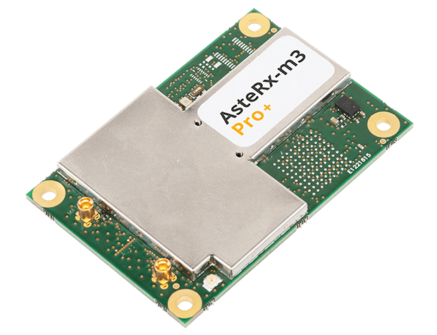
OEM
Receiver board
Enhanced with corrections
Photo: Septentrio
The AsteRx-m3 Sx OEM board dual-antenna receiver combines Septentrio’s latest core GNSS technology with the SECORX-S sub-decimeter correction service to enable plug-and-play positioning. High-accuracy positioning is available directly out of the box, GNSS corrections automatically streamed to the receiver. This significantly simplifies the set-up process and eliminates the need for corrections service subscription and maintenance. Corrections are delivered via internet or L-band satellites, ensuring sub-decimeter service even in remote locations where there is no easy internet access.
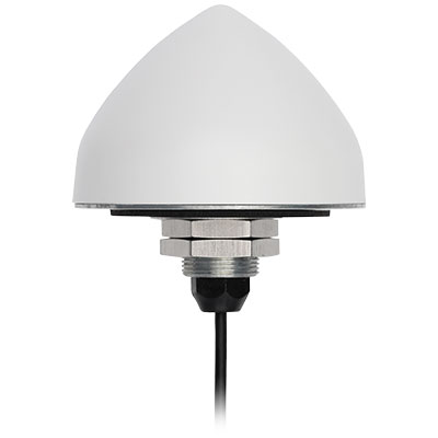
The new TW5382 smart GNSS antenna is designed for high-accuracy 5G timing. The TW5382 is a multi-band, multi-constellation 5G smart GNSS antenna/receiver that provides 5 ns (1-sigma, clear sky view) timing accuracy. It consists of two components: a Tallysman GNSS Accutenna technology antenna and a professional-grade GNSS timing receiver module. Accutenna supports the full bandwidth of the TW5382 receiver, strong multipath mitigation and deep filtering in a compact IP69K enclosure. These features enable the antenna to provide a strong, pure, in-band, right-hand circular polarized signal to the receiver. The TW5382’s professional-grade multi-constellation and multi-signal timing receiver tracks GPS/QZSS (L1/L2), GLONASS (G1/G2), Galileo (E1/E5b), and BeiDou (B1/B2) signals.
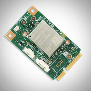
The new Precision GNSS Module (PGM) is designed to offer fast evaluation and a quick path to production for those requiring a precise positioning solution. It is available in a simple-to-use, industry-standard mPCIe (mini peripheral component interconnect express) format and is designed specifically for Swift’s Starling positioning engine running on a host application processor to deliver real-time precision navigation. The PGM utilizes STMicroelectronics’ TeseoV chipset in Quectel’s multi-constellation, dual-band LG69T-AP receiver to create an affordable, easy-to-use solution for customers building industrial, last-mile and internet of things (IoT) platforms. This solution operates with the highest accuracy when used with Swift’s Skylark positioning service.
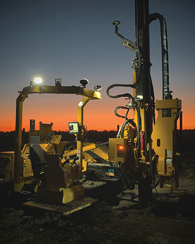
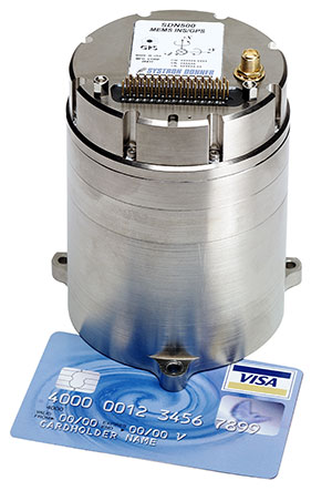
CAST Navigation tested Emcore’s SDN500 inertial navigation system (INS) in an ultra-high-altitude flight simulation and achieved success. The test required simulating performance at an altitude of more than 24,000 meters and velocities over 600 m/s. Only a few aircraft in the world have such capabilities, including the SR-71 Blackbird, but it is not practical to participate in a test flight on the SR-71. Simulating the SDN500 INS test flight to specific customer profiles on a CAST system is straightforward and cost-effective. Emcore relies on GNSS/INS simulators for hardware-in-the-loop testing to verify the expected performance of algorithms. Emcore sought to validate the velocity and altitude limits of a new GNSS receiver along with the algorithm performance in a tactical-grade SDN500 system.
The Dimensity 700 5G smartphone chipset is a system on chip (SoC) designed to bring advanced 5G capabilities and experiences to the mass market. MediaTek’s Dimensity family of 5G chips is designed to give device makers a suite of options for 5G smartphone models. The chips range from flagship and premium to mid-range and mass market devices to make 5G more accessible for consumers everywhere. GNSS signals received include GPS L1CA and L5, BeiDou B1I and B2, GLONASS L1OF, Galileo E1 and E5, QZSS L1C and L5, and NavIC.
IHawk allows users to inspect sites remotely and then download and view the analysis anywhere in the world. It eliminates the need for engineers to climb towers for inspections or work in hazardous environments. The imagery and information gathered provides a detailed and highly accurate analysis of the condition of power transmission towers.
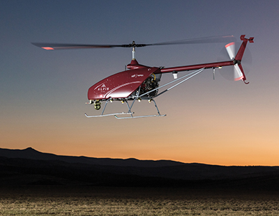
The Alpin UAS is a long-range, heavy-lift unmanned helicopter capable of carrying up to 160 kg with a range of up to 840 km. The UAS includes a wideband satellite communication channel from its command-and-control station — a valuable feature, particularly for operations in remote areas. The Alpin unmanned helicopter is able to withstand severe weather conditions, carry multiple payloads, and transmit real-time information to defense forces and decision-makers in the field. Its system autopilot has features and advantages such as fully autonomous take-off and landing, remote ground-control network capability, auto-rotation landing capability and high efficiency flight control based on a total energy control system (TECS).
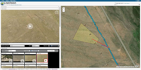
LineVision Online now provides enhanced support for visualizing and mapping DJI drone video camera metadata and field-of-view projections. The secure web application is designed for immersive mapping, analysis, search, sharing and archive of geo-referenced videos, full-motion video, photos and other survey, inspection and surveillance datasets. With enhanced camera metadata mapping in LineVision Online, DJI drone videos can now display a dynamic, field-of-view outline representing where the gimbal camera was looking on the Earth as the video plays in the web-based map interface. Users can select any point along the UAV’s flight track on the map to immediately cue the video to play what was recorded at that location click point.
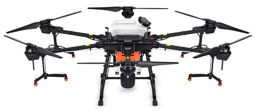
The Agras T20 drone can conduct autonomous operations over a variety of terrains, such as broad-acre farmlands, terraces and orchards. As a comprehensive spraying system, the T20 allows users to easily set flight and operation parameters. With a built-in real-time kinematic (RTK) centimeter-level positioning system and RTK dongles, centimeter-level waypoint recording is enabled, strengthening operations and ensuring precision spraying.The T20 is equipped with eight nozzles and high-volume pumps that can spray at a rate of up to 6 liters per minute. A highly optimized wind field produces droplets of the correct size and consistency. The T20 is also equipped with a new four-channel electromagnetic flow meter, which monitors and controls four hoses individually, ensuring an efficient flow rate for each nozzle.
A new virtual base station (VBS) feature is available in Qinertia, GNSS and inertial navigation system (INS) post-processing software. Trajectory and orientation are greatly improved by processing inertial data and raw GNSS observables in forward and backward directions. The VBS computes a virtual network around a project in which position accuracy is maximized, homogeneous and robust, such as a PPK short baseline. Once surveyors collect data, Qinertia chooses the most relevant reference stations, builds a virtual network and brings the project to centimeter-level accuracy with no convergence effects, even in urban areas.
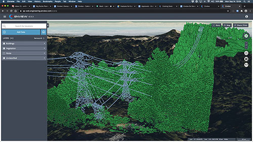
Enview Explore is a powerful web application that leverages artificial intelligence and cloud computing to automatically process 3D data at a high speed and scale. Enview performs a variety of geospatial operations, including object recognition, feature extraction, feature-based change detection, and 2D/3D measurement. Enview’s technology has been deployed on thousands of square miles worldwide to protect vital infrastructure and support mission-critical operations. Its unique method for classifying 3D data reduces time to action by focusing on finding meaningful insights.
PDGrade — a machine guidance and positioning system that uses GNSS for pile driving applications — is now optimized for the solar industry with an increased capability in pile installation and navigation accuracy. It removes the need for surveying piles and reviewing as-built information by centralizing all relevant information and providing necessary details to operators and site supervisors.The system features both software and hardware applications to provide operators with detailed information such as pile navigation, pile location, positioning and height information, project progression tracking, and detailed accuracy. The PD machine is fitted with Carlson sensors and a ruggedized Windows-based MC10 tablet. The entire system is then calibrated within PDGrade.
SPH Engineering has launched a drone-integrated metal detection system with a Geonics EM61Lite metal detector, a new product of UgCS Industrial Solutions. The same performance and robustness available for users of the standard EM61-MK2 time domain metal detector are now available for airborne use.
The new system is capable of detecting metallic (magnetic and non-magnetic) items in the first few meters under the surface, finding metallic objects in hard-to-reach or dangerous areas.
Applications include unexploded ordnance (UXO) search, detection of underground infrastructure and archaeology. The integrated system has been extensively tested at SPH Engineering’s test range, and has shown excellent performance and repeatability for targets such as pipes (steel, stainless steel, reinforced concrete) and steel drums.
The system uses an airborne (less heavy) modification of the Geonics EM61-MK2 ground metal detector. The EM61 Lite airborne variant integrates with the UgCS SkyHub onboard computer and ground control station.
Features include automatic data logging in geotagged form and automatic terrain following with radar altimeter. The use of UgCS SkyHub enables the drone to fly in true terrain following (TTF) mode with the help of the radar altimeter and to log geotagged sensor data.
An optional RTK/PPK GNSS receiver on the drone will geotag the data with centimeter-level precision.
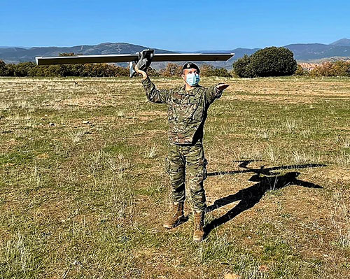
The Spanish Army and Navy have received the first Seeker Remotely Piloted Aircraft Systems (RPAS) from GMV and Aurea Avionics. The unmanned aircraft is designed to boost the intelligence, surveillance and reconnaissance capabilities of two elite forces, the Spanish Army’s 6th Almogávares Paratroopers Brigade and the Marine Infantry Protection Force.
Seeker has a 90-minute endurance and 15-km range, and weighs 3.5 kg. The UAV’s design and manufacture in Spain proved crucial during the COVID-19 epidemic, with the manufacture, test flights and delivery of the aircraft all performed within the project deadlines.
In the final phase of the project, intensive training courses took place on the Madrid site of Aurea Avionics and the Los Alijares Firing and Maneuvering Range (CMT) of Toledo. There, future Seeker users put the RPAS through its paces with mission simulations, engaged in vehicle-tracking exercises and learned about its theoretical and practical uses.
Seeker will provide BRIPAC (Paratrooper Brigade) and BRIMAR (Marine Infantry Brigade) with real-time thermal-infrared and visible-spectrum video, augmented by metadata that can be mined by the operators and remotely by the command-and-control centers.
New digitized ground-station architecture makes Seeker compatible with NATO’s standard command centers. This means any allied force will be able to integrate the aircraft into its fleet and command centers, ensuring joint operability between all troops and systems.
The RPAS is financed by the Subdirectorate General of Planning, Technology and Innovation of the Directorate General of Armaments and Material.
FLIR Systems Inc. has acquired Altavian Inc., a privately held manufacturer of small unmanned aerial systems (sUAS) for defense and public-safety customers.
Altavian’s airframes integrate multiple sensors, including FLIR thermal technology, to provide users with decision support and intelligence, surveillance and reconnaissance (ISR) capability.
Based in Gainesville, Florida and founded in 2011, Altavian designs and manufacturers Group 1 UAS solutions for long or short range operations. With both quadcopter and fixed-wing UAS designs, Altavian’s expertise includes aeronautics, avionics, and software, and its solutions are engineered around an open system architecture aligned to the needs of government and defense customers.
Altavian is one of five drone manufacturers approved by the U.S. Department of Defense under the Blue sUAS program to sell to the U.S. military and federal agencies.
“Altavian’s proven engineering expertise and assets will allow us to offer customers the most comprehensive solution portfolio of any American sUAS provider,” said Roger Wells, general manager of the Unmanned Systems and Integrated Solutions business of FLIR Systems’ Defense Technologies Segment, under which Altavian will be integrated. “With the addition of both a low-cost, rapidly deployable quadcopter and a longer range fixed-wing UAS, FLIR is strengthening its already impressive drone lineup, including our Black Hornet and SkyRaider platforms used extensively by militaries around the globe. We’re excited about the multiple new franchise opportunities FLIR will be able to pursue for defense, public safety, and industrial markets worldwide.”
For more information about FLIR Systems’ existing sUAS solutions, visit flir.com/defense-uas.
The UPP results will provide a proof of concept for UTM capabilities and serve as the basis for policy considerations, standards development and the implementation of a UTM system.
“The demonstrations will help move us closer to safe beyond-visual-line-of-sight drone operations,” said Pamela Whitley, the FAA’s acting assistant administrator for NextGen. “Flight testing UTM capabilities in high-density airspace will help us develop policy for safely and efficiently integrating drones into our national airspace while benefiting and serving communities.”
The demonstrations showcased emerging UTM capabilities that will support beyond-visual-line-of-sight (BVLOS) operations:
The FAA UTM Flight Information Management System prototype and infrastructure, which gives the FAA access to information from industry and other stakeholders.
New technologies and data to validate the latest international standards for remote identification and support authorized users with specific operator data.
In-flight separation from other drones or manned aircraft in high-density airspace to validate recently proposed international UTM standards to help drones avoid each other.
UAS volume reservations to notify drone operators of emergencies and make sure other UTM capabilities work properly in these scenarios.
Secure information exchanges between the FAA, industry and authorized users to ensure data integrity.
Each event attracted more than 100 participants and included local and state elected officials and representatives from international civil aviation authorities. Both test sites collaborated with drone operators and local public safety agencies to demonstrate scenarios that featured various complex UTM capabilities working together to support BVLOS operations with increasing volumes and densities.
MAAP hosted an event on Oct. 28 in partnership with UAS Service Suppliers (USS) AirMap, AiRXOS, ANRA Technologies, and Wing. On Nov. 9, NYUASTS hosted its showcase in coordination with the Griffiss International Airport, Northeast UAS Airspace Integration Research Alliance (NUAIR), and USS partners AiRXOS, ANRA Technologies, AX Enterprize, and OneSky.
The FAA has worked closely with NASA, industry and other stakeholders since 2017 to identify the initial set of capabilities needed to support small drone operations and advance UTM. The FAA Reauthorization Act of 2018 extended the objectives of the program to further enable safe BVLOS drone operations, paving the way for the program.
Stay tuned for more updates on how emerging technologies are being field tested to support the growing UAS industry.
Esri is offering two major capabilities in Site Scan for ArcGIS that will enable governments and critical infrastructure organizations to meet hardware and software regulations in the United States and Europe. Site Scan is Esri’s unmanned aerial systems flight planning and processing solution.
Through an established partnership with Auterion, creator of an open-source drone autopilot operating system, security-conscious U.S. organizations will be able to use Site Scan to plan and execute missions with Auterion’s Freefly Astro drone.
In Europe, data from publicly funded or critical infrastructure projects cannot leave the European Union (EU). For these organizations, a new and fully independent instance of Site Scan for ArcGIS has been deployed to a server cluster in Ireland, ensuring that organizational data resides within the region.
Site Scan for ArcGIS is used by organizations that require drone imagery for visual inspections, site monitoring, asset management and situational awareness. It’s an all-in-one, cloud-based drone mapping solution for managing fleets and collecting, processing, analyzing, and sharing data products. Industries using this solution include architecture, engineering, construction, natural resources, infrastructure and government.
Freefly Astro uses U.S. Department of Defense-approved Blue sUAS software architecture from Auterion, and is fully supported by Site Scan. The first vehicle integrates the software with the Freefly Astro, with more vehicles becoming available.
Auterion’s secure, integrated workflow for mapping uses the Freefly Astro drone, Sony A7R4 camera and Esri Site Scan within a single platform.
The Freefly Astro and Site Scan integration will be available by December. The European deployment of Site Scan is available now.
A solution for these COVID-19 days, getting to injured people really fast, and potentially even faster first response applications are all new drone applications featured in this month’s UAV summary.
As people welcome back football this fall — although playing in empty stadiums – most people are staying home to watch the game on TV. Even though some sports teams like the MLB Dodgers resorted to cardboard cut-outs of fans, maybe to encourage players, nothing beats having real people stamping and cheering in the stands.
So its not surprising that when the Atlanta Falcons play the Carolina Panthers this month at Atlanta’s Mercedes-Benz Stadium, they are planning on having a limited number of real live fans at the game to cheer on the teams. Even in these pandemic days of social distancing and masks, it would seem that a reduced number of fans might space out well in the huge 71,000 seat capacity stadium.
But the drone angle comes with the clean-up afterwards — 71,000 seats, handrails and partitions take a lot of manual wiping down – so the Atlanta Falcons are bringing on disinfecting drones to do the job, potentially with only 5% of the effort it normally takes.
There are two D1 drones being used in Atlanta supplied by Lucid, each equipped with a 2.5-gallon tank filled with nontoxic disinfecting chemicals. The sanitation solution is distributed by specially designed ‘electrostatic nozzles’ which spray evenly and mist the area as the drone passes over.
Disinfecting drones have been used before in places which include several locations in China, the city of Dubai, and company EagleHawk in New York offers drone sanitizing for stadiums and other large public facilities. If this approach works we’ll probably see it in many more stadiums in an effort to safely bring back the fans.
Not sure how this next item fits into the unmanned category for this month’s article — because its certainly manned. But what the heck, its certainly interesting and worth a whirl.
Jet packs have been around for a while, but the U.K. company Gravity has come up with a configuration that appears to be reliable and works well. They recently pitched their system for search and rescue in the Lake District — a mountainous area in the North West of England which is extremely popular for hiking, walking and climbing. So visitors will sometimes get hurt falling off a ledge or a high path on the side of a mountain, or just tripping while walking and injuring an ankle, leg or knee. The rocky hilltops, mountains and many lakes of the Lake District attract around 15 million visitors each year, so there is plenty of opportunity for injuries.
With five miniature jet engines and carrying around 35 liters of jet fuel, the Gravity system range/endurance isn’t that great, but boy is it quick if you want to run up the side of a mountain to find an injured hiker. So more rapid response rather than search — provided you already know where the person is located.
The system is powered by a double jet-engine held at the end of each arm and a single engine with equivalent thrust housed in the actual backpack. Altogether, over a 1000 horse power, which is apparently enough to pick a person up and keep them suspended at around 10 feet off the ground. Guess you would need quite some strength to hold onto the arm units, supporting one-third of your weight on each arm, but apparently you get some level of stability assistance from a flight control system in the backpack.
A recent demonstration test in the Lake District with the Great North Air Ambulance Service certainly showed off the suit’s capability to go from the foot of a mountain up to near the crest of the hill in no time flat. Then a regular air-rescue helicopter was immediately called in to take the victim to hospital. However, the current system apparently costs somewhere around $400,000, so its doubtful it will show up for anything but special appearances and demos until there has been significant engineering cost reduction.
The “Recruit” hi-speed drone is aimed at rapid first response users (Photo: Sonin)
Sonin Hybrid has taken another angle to building a drone by developing a hybrid gas powered propulsion system which charges the vehicle’s batteries while in flight, uses a lightweight carbon-fiber frame with folding landing-legs, and is able to fly at up to 140 mph when pressed to do so. Nominal cruise flight is at 60mph, and flight endurance is claimed to be up to 3 hours – over 5 times that of similar competitor drones.
The Recruit’s options include a stabilized 4k camera, a night vision/IR camera, 30x optical/12x digital zoom camera, a 6k lumen spotlight and a loudspeaker/siren.
With several trials currently underway with first responders, Sonin is eager to establish the requirements for police, fire and military applications. Let’s hope that the trials all involve getting eyes on a location as quickly as possible so hi-speed drone capabilities are needed. Otherwise all the drone racers will probably scoop up these 140mph puppies.
So to enable people to perhaps return to watching sports in person during the ongoing pandemic we have drones pumping disinfecting spray all over sports stadiums which can potentially save huge amounts of manual cleaning effort, provided they can adequately sanitize the target areas — specialized spray nozzles help. Then we have a jet-pack system which was demonstrated getting to injured people as quickly as possible to administer immediate care, followed up by helicopter air rescue. And finally if you want a hi-speed, lightweight drone with good payload capability, Sonin has launched the 140mph Recruit aimed at first responders who need a very quick first response.
These are all completely different applications, all with completely different solutions.
Walmart is teaming up with drone delivery company Zipline to launch a drone delivery operation in the United States. According to Walmart, this first-of-its-kind drone delivery service will make on-demand deliveries of select health and wellness products with the potential to expand to general merchandise.
Trial deliveries will take place near Walmart’s headquarters in Northwest Arkansas. The trials will use Zipline’s proprietary technology.
Zipline will operate from a Walmart store and can service a 50-mile radius, Walmart said. The company’s launch-and-release system allows for quick on-demand deliveries in under an hour, and it also eliminates carbon emissions, Walmart added.
Zipline began operating in 2016 in Rwanda, primarily focusing on the on-demand delivery of medical supplies. According to Zipline, it has safely delivered more than 200,000 critical medical products to thousands of health facilities serving more than 20 million people across multiple countries.
The operation will likely begin in early 2021, Walmart said.
The U.S. Federal Aviation Administration (FAA) has made it easier for drone pilots to quickly and safely access controlled airspace by adding 133 air traffic facilities to the Low Altitude Authorization and Notification Capability (LAANC) system. The expansion is based on feedback from the drone community.
LAANC is an automated application and approval system for drone pilots requesting to fly below 400 feet in controlled airspace.
As the FAA continues to modernize the national airspace to accommodate more users, the agency made LAANC accessible for 726 airports and 537 facilities, covering 81% of eligible airspace.
LAANC is a collaboration between the FAA and the unmanned aircraft systems (UAS) industry which directly supports the safe integration of drones into the nation’s airspace. The service is accessible to all pilots who operate under the FAA’s small drone rule.
The COVID-19 pandemic has brought uncertainties to all businesses, and the mapping industry has been no exception.
Slowdowns were observed during the first few months of 2020 as lockdowns were gradually enforced in Asia, then Europe, and finally the Americas.
As expected, projects were delayed during that initial period as companies were reorganizing their operations to allow for remote work.
Once that transition was overcome, a great number of projects resumed, and the geospatial field has been gradually coming back to normal since then. That can be explained by different factors, including, for example, several governments accelerating infrastructure projects to stimulate the economy.
A lot of mapping firms have turned the pandemic into an opportunity to improve their processes. Slower times allow reviewing production workflows and assessing bottlenecks. Once identified, new hardware and software solutions can be evaluated to optimize production.
Interestingly, the resulting investments into new solutions has been significant. Companies are seeing a quick payoff as their workload is rapidly accelerating, leading to an increase in their bottom line.
Overall, the mapping industry was able to rapidly adjust to the new reality caused by the pandemic. The changes that are being made in performing projects not only allow us to minimize risks in the short term, but also to increase profitability in the longer term.
SimActive is the developer of Correlator3D software, a patented end-to-end photogrammetry solution for the generation of high-quality geospatial data from satellite and aerial imagery, including drones. Correlator3D performs aerial triangulation (AT) and produces dense digital surface models (DSM), digital terrain models (DTM), point clouds, orthomosaics, 3D models and vectorized 3D features.
Powered by GPU technology and multi-core CPUs, Correlator3D ensures high processing speed to support rapid production of large datasets.
SimActive has been selling Correlator3D to leading mapping firms and government organizations around the world, offering cutting-edge photogrammetry software backed by exceptional customer support.
Advancements in sensors, cameras and automation have fueled the growth of the aerial imaging industry, which is expected to reach $2.83 billion by 2022.
By Swamini Kulkarni
Unmanned aerial vehicles (UAV), or drones, often gain the spotlight with to their ability to capture the view from a vantage point. For years, airborne cameras have clicked never-seen-before pictures across planet. Now imaging technology is utilized to monitor natural calamities and borders of countries.
Drones have been quickly adopted in various industries including surveillance, geospatial mapping, post-disaster monitoring, and even entertainment. The advancements in sensors, cameras and automation have fueled growth of the aerial imaging industry.
Cameras mounted on balloons, kites and now drones are used widely across various verticals such as government, agriculture, civil engineering and research. Surveillance through satellite imagery has challenges, many of which drones can overcome. Drones can be used whenever we want and can be equipped with lidar systems, geographic information systems and advanced cameras. This has created lucrative opportunities in the aerial imaging industry.
According to Allied Market Research, the global aerial imaging market is expected to reach $2.83 billion by 2022, growing at a CAGR of 12.9% from 2016 to 2022. The launch of novel and intuitive cameras has further increased the popularity of aerial imaging.
Advent of novel, intuitive cameras for aerial imaging
AirSelfie, a prime market player in the aerial imaging industry, launched AIR PIX aerial camera at Consumer Technology Association (CES) 2020. The company announced that it has started shipping AIR PIX+ to customers the world’s smallest pocket-sized aerial camera. Moreover, it declared that it would make available AIR DUO, the aerial camera equipped with the dual parallel camera later in 2020. Both of these cameras offer state-of-the-art technology and would prove to be vital in aerial imaging and capturing videos from the air.
Skydio, the leading U.S. manufacturer of drones and autonomous flight technology, recently launched new software solutions and autonomous drone platform for situational awareness and inspection. It is observed that despite the potential drones showcase in aerial imaging, its adoption is still limited due to concerns regarding the risk of crashes of autonomous drones.
Moreover, the requirement to hire experienced pilots and data security concerns prevent firms from scaling their aerial imaging programs. That’s why Skydio aims to unlock the potential through this autonomy software and change people’s perspective toward drones.
In addition, the company has partnered with Eagleview, a leader in aerial imagery industry and data analytics to empower home insurance agents to offer accurate inspection of residential homes without the use of expert drone pilots. This technology is expected to be available in the fourth quarter of 2020.
Artificial intelligence: Future of aerial imaging
Today, every industry is searching for ways to operate devices remotely or at least with minimum physical contact. With the experience of global pandemic keeping in mind, the future is clearly bright for autonomous drones.
Several industries, including aerial imaging, rely on advancements in autonomous UAVs. Moreover, the success of aerial imaging depends on both autonomous drones and carefully dealing with the data gathered by aerial cameras. This is where artificial intelligence (AI) comes into the picture.
For use of aerial imaging for property surveillance, there is a dire need for a solution that can streamline data analysis, make sense of the data gathered by cameras, and scale up the level of details offered by aerial imaging.
AI-based aerial imaging can be used for automated property analytics and streamline facilitation of risk underwriting and claim management. Moreover, it can offer datasets to improve risk modeling. AI-powered aerial imaging technology can leverage AI to detect changes in property evaluation, which can benefit public safety and city planning.
COVID-19 increases data demand
We live during a period of drastic change. The COVID-19 pandemic has influenced almost every industry across the globe and has increased the demand for quality of data despite a lack of resources. Moreover, there is a need for faster and better data analysis to help industries scale up. The incorporation of AI and aerial imaging can benefit organizations to scale up their operations and streamline their processes at affordable costs.
Nearmap, a prominent aerial imagery company, has launched its innovative Nearmap AI for automatic aerial imagery insights at scale. This technology is the first among aerial imagery to offer AI analysis along with high-definition aerial images on a commercial scale. Moreover, it enables customers to automatically detect ground features and verify insight against aerial imagery at a larger scale.
It is clear that the use of aerial imaging will increase in the future. Moreover, the integration of AI in aerial imaging will help organizations to scale up their business and aid in data analysis to gain valuable insights.
It is safe to say that the aerial imaging technology has changed over time, but the desire of humans to see the world from a high above has been constant, which is exactly what should keep aerial imaging technology profitable in years to come.
Allied Market Research is offering a market report on aerial imaging.
Swamini Kulkarni
Swamini Kulkarni holds a bachelor’s degree from Pune University, India, and works as a content writer.