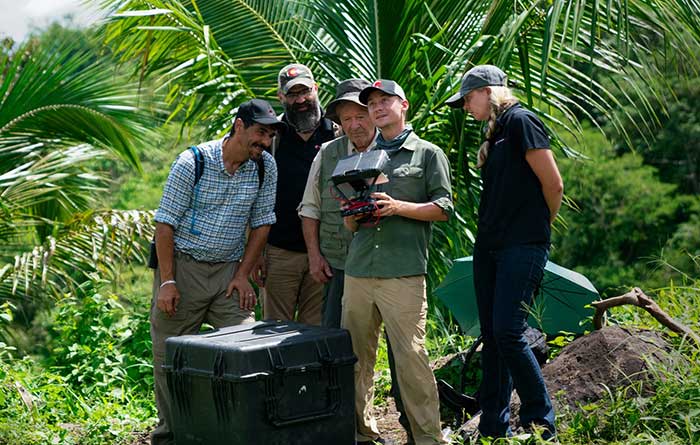
The technology multinational GMV has won a contract under the Spanish Ministry of Defense’s (MoD’s) RAPAZ program for the supply of four Class I Seeker RPASs to be integrated into the intelligence units of the Paratrooper Brigade and the Tercio de Armada de Infantería de Marina (Marine Infantry Protection Force).
The contract will provide the armed forces with the most advanced version of the unmanned aircraft Seeker.
The UAS Seeker is an autonomous, rapid-deployment system developed by Aurea Avionics and supplied by GMV. It provides intelligence, surveillance and reconnaissance capabilities over a 15-kilometer range with a 90-minute endurance and a weight of 3.5 kg.
The aircraft will strengthen the intelligence, surveillance and reconnaissance capabilities of Spanish troops, ensuring better operational capability and tactical superiority.
Seeker constitutes the core of a situational awareness system, providing real-time intelligence. It is designed for rapid-deployment and high-mobility military applications carrying out low-level intelligence, surveillance and reconnaissance tasks.
The system components can be broken down into two major groups: the air segment and the ground segment. The air segment comprises the unmanned aerial system (UAV), fit for daytime and nighttime operations and capable of completely autonomous flying. The ground segment comprises a ground control station, a ground data terminal, and a remote handheld control. These systems between them monitor the UAV’s operation and process its real-time video data.
Within this project, due for delivery by October 2020, GMV will be running the design and manufacturing activities and also the various flight campaigns scheduled to check that the systems work properly before handover to the MoD.
GMV developments for unmanned aircraft
GMV boasts great expertise and experience in Unmanned Aerial Systems (UAS), built up on the strength of many previous projects such as ATLANTE, where it developed the aircraft’s flight control computer; EGNSS4RPAS, where it weighed up EGNOS performance for RPAS operations; and DOMUS, where it developed emergency-management and -monitoring service demonstrators for drone traffic control under the U-Space system.
This Spanish MoD Seeker system supply contract boosts GMV’s growing renown as developer and supplier of UAV systems and services.
Orolia has introduced a low SWaP-C miniaturized rubidium oscillator, the Spectratime mRO-50, designed to meet the latest commercial, military and aerospace requirements where time stability and power consumption are critical. The oscillator is low SWaP-C — size, weight, power and cost.
The Spectratime mRO-50 provides a one-day holdover below 1 µs and a retrace below 1 x 10⁻¹⁰ in a form factor sized 50.8 x 50.8 x 19.5 millimeters. It takes up only 51 cc of volume — about one-third of volume compared to standard rubidiums — and consumes only 0.45 W of power.
he Spectratime mRO-50 miniaturized rubidium oscillator provides accurate frequency and precise time synchronization to mobile applications, such as military radio-pack systems in GNSS-denied environments. Its operating temperature of -10°C to 60°C (military version extends to -40°C to 75°C) is also suitable for UAVs and underwater applications.
Orolia is a leader in space-based atomic clocks and high-end crystal, rubidium, hydrogen maser and integrated GPS/GNSS clocks. The company also provides testing instruments for space missions that rely on high precision atomic clock technology.
Orolia’s Atomic Clocks team received the 2019 PTTI Distinguished Service Award in January for advancing the state of the art in high-stability atomic clocks and producing the only space-based passive H-maser in the world, operating on all Galileo satellites. Spectratime mRO-50 is the latest technology solution from this award-winning team.
“Through Orolia’s continuous commitment to innovation, we are proud to offer our customers more precise PNT data in a cutting-edge, lightweight form factor for mobile missions,” said Orolia’s Atomic Clocks Product Line Director, Jean-Charles Chen.
SPH Engineering has launched a product designed to conduct bathymetric surveys of inland and coastal water.
The system — an unmanned aerial vehicle (UAV) integrated with an echo sounder — is time- and cost-efficient, the company said. It is suitable for mapping, measuring and inspecting tasks as well as environmental monitoring.
The system allows field workers to collect data with high accuracy quickly. It is easily transported, quickly deployed and twice as cost-efficient as traditional methods.
The UAV/echo sounder system can be operated in hard to reach locations, and unsafe or hazardous environments. Locations not reachable by foot or that are dangerous for a human (steep coasts, mining pits, contaminated waters, terrain obstacles, etc.) as well as waters of ponds, lakes, and canals can be reached by the drone.
“Since autumn 2018 we have been getting bathymetry-related requests,” said Lexey Dobrovolskiy, CTO of SPH Engineering. “Analyzing about 150 inquiries, we have come to the conclusion that a drone-based solution could open a new business opportunity for drone service companies to do bathymetry surveys of coastal and inland water, especially those for industrial needs.
“Compared with a standard approach using a boat or an unmanned surface vehicle, a drone could save a lot for its user,” Dobrovolskiy said. “An echo sounder itself could be integrated into a client’s drone with no need to purchase additional equipment. Moreover, it is small and easy to transport and operate. At the same time, such research method guarantees data accuracy and employee safety.”
Altitude Angel, a London, U.K.-based unmanned traffic management (UTM) technology provider, is releasing an open-sourced project, Scout.
Scout’s hardware and firmware enable drone manufacturers, software developers and commercial drone pilots to quickly connect to its global UTM.
Primarily intended for use in commercial and industrial drone applications, Scout provides the capability to securely obtain and broadcast a form of network remote ID, widely seen as a necessary step for enabling routine drone use and flights beyond visual line of sight.
Because it is open source, both the hardware and the firmware can be enhanced and incorporated into a virtually limitless set of scenarios, according to Altitude Angel.
Altitude Angel also has made available a surveillance API that allows integrators to both share and receive flight data from a variety of sensors and devices in near real time, providing a comprehensive real-time picture of the airspace.
While many remote ID systems are broadcast only, Scout offers two-way communication and is fully open-sourced. The ability to talk back to the drone enables the Altitude Angel UTM service to help the drone avoid collisions with other aerial vehicles, or restricted airspace.
From launch, Scout will use identifiers obtained freely from Altitude Angel’s GuardianUTM platform. It will work in combination with a pre-flight (flight-plan sharing) service and is supported through integration with Altitude Angel’s Tactical Conflict Resolution Service.
Scout will enable the drone to report its real-time location using GPS-type sensors and relay this data via a secure, encrypted mobile communications link across 3G, 4G and 5G networks to Altitude Angel. It is powered by an internal rechargeable (via micro USB) lithium battery.
Altitude Angel has also provided reference design plans for the case that can be 3D printed. Scout has been designed to satisfy emerging network remote ID standards, such as ASTM.
Because the firmware is open source, the telemetry can be sent to other systems as required by the implementor.
A two-wire I2C upgrade to the circuit schematics, plus version 2 of the firmware (both scheduled for June), will subsequently enable the full two-way communication between the Scout device and the drone’s onboard systems, allowing the drone to respond directly to information received from the UTM.
In the interim, early adopters will have the opportunity to begin to integrate with Altitude Angel’s UTM services, test the hardware and test communication. Position data Altitude Angel receives from Scout is then automatically used by its Flight Information Management System (FIMS) to help provide traffic deconfliction.
Plans, firmware and schematics can be accessed via the Altitude Angel GitHub repositories.
SPH Engineering has launched a new product to make bathymetric surveys of inland and coastal water.
The system — an unmanned aerial vehicle (UAV) integrated with an echo sounder — is time- and cost-efficient. It is suitable for mapping, measuring and inspecting tasks as well as environmental monitoring.
The system allows field workers to collect data with high accuracy quickly. It is easily transported, quickly deployed and twice as cost-efficient as traditional methods.
The UAV/echo sounder system can be operated in hard to reach locations, and unsafe or hazardous environments. Locations not reachable by foot or that are dangerous for a human (steep coasts, mining pits, contaminated waters, terrain obstacles, etc.) as well as waters of ponds, lakes, and canals can be reached by the drone.
“Since autumn 2018 we have been getting bathymetry-related requests,” said Lexey Dobrovolskiy, CTO of SPH Engineering. “Analyzing about 150 inquiries, we have come to the conclusion that a drone-based solution could open a new business opportunity for drone service companies to do bathymetry surveys of coastal and inland water, especially those for industrial needs.
“Compared with a standard approach using a boat or an unmanned surface vehicle, a drone could save a lot for its user,” Dobrovolskiy said. “An echo sounder itself could be integrated into a client’s drone with no need to purchase additional equipment. Moreover, it is small and easy to transport and operate. At the same time, such research method guarantees data accuracy and employee safety.”
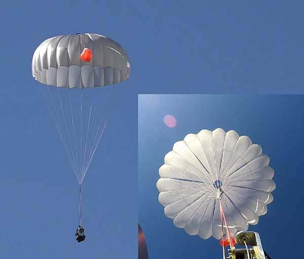
UAVOS has successfully tested its new two-stage parachute system. The new parachute system provides slow descent of a UAS at high speed. It includes two parachutes — the pilot chute and a main chute used to slow and stabilize the UAS.
The decrease in the load speed on the UAS occurs due to the main chute opening delay function, when the pilot chute opens first. The parachute system is designed for UAS with speeds of up to 280 mph (450 kph) and weight of up to 110 lb (50 kg).
Watch the parachute in action:
The pilot chute allows safe, slow descent of the UAV during the main parachute deployment, as well as to open up the main chute at a minimum altitude.
After landing, the group of the main parachute lines is automatically unfastened to collapse the canopy of the main chute and releases after touchdown to avoid dragging the aircraft along the ground. Unfastening is carried out by the lock of a three-step release:
Stage 1: Opening the pilot chute
Stage 2: Opening the main chute
Stage 3: Release of the group of lines of the main parachute
“In the aircraft safety developments, saving an entire aircraft through a deployable parachute system is a crucial thing,” said Aliaksei Stratsilatau, CEO and lead developer of UAVOS. These trials have generated an amount of data that allows us to quantify the performance of parachute system for future missions. Computer modeling cannot capture all the complexities. Parachutes encounter turbulent and dynamic airflow, which is almost impossible to replicate with computers. The only way to get a handle on all the possibilities is test.”
Draganfly conducted its first series of U.S. pandemic drone test flights in Westport, Connecticut.
Draganfly’s pandemic drone technology is being tested by the Westport Police Department as a new “Flatten the Curve Pilot Program.” According to Draganfly, this initiative is a collaboration of technologies developed by Draganfly, Vital Intelligence, a healthcare data services and deep learning company, and the University of South Australia.
Westport is located in Fairfield County, which has more than 17,550 confirmed cases of COVID-19. Fairfield County is adjacent to New York City, which has the most confirmed cases of coronavirus in the United States.
Image: Draganfly
Westport is deploying the technology and data tools to enhance town services, advance public safety, promote the efficient use of taxpayer dollars, engage residents and encourage growth in the local economy.
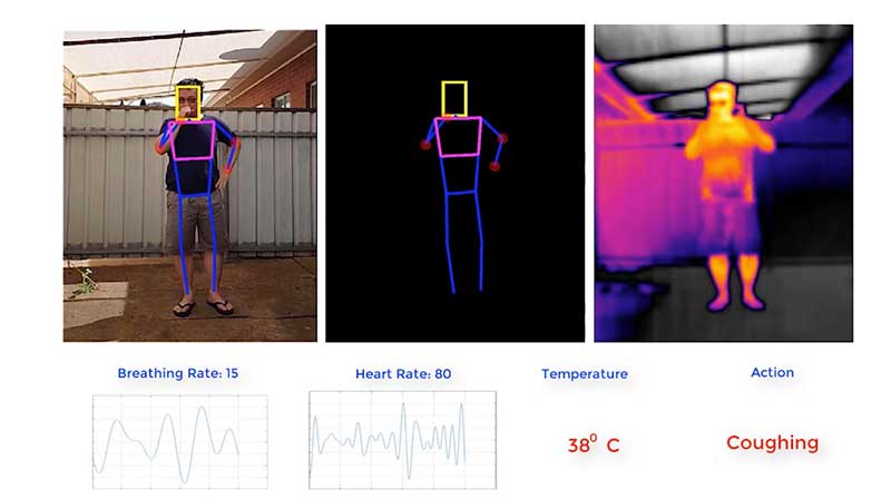
The pandemic drone will be equipped with a specialized sensor and computer vision systems that can display fever/temperature, heart and respiratory rates, as well as detect people sneezing and coughing in crowds, and wherever groups of people may work or congregate. The technology can accurately detect infectious conditions from a distance of 190 feet, as well as measure social distancing for proactive public safety practices, Draganfly said.
Westport specifically plans to use the drone technology to help protect potential at-risk groups, crowds gathering at the town and state-owned beaches, train stations, parks and recreation areas, shopping centers and other areas where people tend to gather.
“One of the major problems for cities and towns like Westport in managing and responding to a pandemic like the COVID-19 virus, is finding out who could be infected and how widespread the disease has spread,” said Jim Marpe, Westport first selectman. “One way to do this is to look for underlying symptoms. By teaming up with Draganfly and the UniSA team, led by Defence Chair of Sensor Systems Professor Javaan Chahl, we are able to remotely look at valuable lifesaving data and better manage current and future health emergencies.”
Draganfly‘s pandemic drone software uses biometric readings in its analysis process. The software can be used to understand patterns within a population to allow users to react quicker to ongoing events or new potential health threats, Draganfly added.
Draganfly manufactures UAVs and UAS, serving the public safety, agriculture, industrial inspections and mapping and surveying markets.
Image: 4X-image iStock / Getty Images Plus / Getty Images
Nearly 4,000 waivers granted under Part 107; about 20 percent of waivers granted to organizations received by first responders
Almost four years after the Federal Aviation Administration (FAA) established rules for the commercial operation of small unmanned aircraft systems (UAS), a new report by the Association for Unmanned Vehicle Systems International (AUVSI) found that nearly 4,000 operators across all 50 states have been granted waivers to go beyond current regulations.
First responders across the country received about 20 percent of all waivers granted to organizations (398), which demonstrates growing interest and need for public safety applications enabled by UAS, including search and rescue and firefighting at night.
Effective Aug. 29, 2016, the small UAS rule, also known as Part 107, created a uniform regulatory framework for UAS. Among the rule’s requirements, UAS must fly below 400 feet above ground level (AGL), within visual line of sight and during daylight hours.
Recognizing the need for the rule to be flexible to foster innovation, the FAA created a waiver process that allows for expanded types of operations, such as nighttime or beyond line of sight operations, with the approval of the agency.
AUVSI analyzed 3,946 of these waiver documents granted by the FAA since Part 107 went into effect. While the vast majority of waivers (3,636 or 92 percent) were granted to waive the requirement for flying only during the daytime to enable nighttime operations, the FAA has also granted waivers from other sections of the regulations to permit advanced operations, including:
Flights over people (112 waivers);
Operation in certain airspace (97 waivers);
Operating multiple UAS at the same time (55 waivers);
Visual line of sight operations (to enable beyond line of sight operations) (51 waivers).
Operators in all 50 states, as well as the District of Columbia and Puerto Rico, have received waivers. California leads the way with 451 waivers granted, followed by Texas (334), Florida (272) and New York (159). About 87 percent of all waivers were granted to small businesses with fewer than 10 employees and annual revenues of less than $1 million.
“Across the country, operators have demonstrated they are eager to harness the tremendous potential of expanded UAS operations,” said Brian Wynne, president and CEO of AUVSI. “Small businesses have been able to save time and money, and first responders and public safety agencies have used UAS technology to increasingly contribute to the greater good worldwide, supporting missions from disaster relief to humanitarian aid.”
Last month, AUVSI submitted its comments on the FAA’s Notice of Proposed Rulemaking (NPRM) for Remote Identification of UAS. In the comments, AUVSI urged the FAA to proceed concurrently with rulemaking that would allow for expanded operations rather than wait for a fully implemented remote ID rule to avoid unnecessary delays. The FAA says it hopes to issue a final rule before the end of the year.
In the interim, the FAA recently announced several initiatives to improve the waiver application process in response to a review last year of the waiver framework by a task group of the Drone Advisory Committee that was chaired by Wynne.
The FAA’s plans include expediting the waiver renewal application process, particularly in instances where there hasn’t been many changes since the original application; enabling quick administrative changes to previously granted waivers; providing more responsive feedback to applications that were not approved; streamlining the applications; implementing new regulations to obviate the need for waivers; and increasing transparency and accountability to provide support for waiver applications, disapprovals, and general UAS questions.
“The waivers that have been granted so far demonstrate that operators are safely able to conduct expanded operations, such as flights over people and beyond visual line of sight,” said Wynne. “While improvements to the waiver process are needed and welcomed, we urge the FAA to move forward rapidly with rulemakings that would enable these operations widely and provide the economic and societal benefits they offer.”
Klau Geomatics has launched MakeItAccurate, a global GNSS data correction and processing service.
MakeItAccurate takes data from any GNSS receiver on drone or survey equipment and makes it accurate. Users can now achieve centimeter (cm)-level accuracy without the need for base stations, real-time kinematic (RTK) links, data from Continuously Operating Reference Station (CORS) or other external inputs.
MakeItAccurate requires only the raw GNSS data from a drone to produce a highly precise trajectory and turn the traditional autonomous 3-5m GPS accuracy to 3-5 cm anywhere in the world.
In many parts of the United States, Europe, Japan, Australia and New Zealand, absolute accuracy of 2-3 cm XYZ will be achieved. In these areas, the KlauPPK processing engine applies sophisticated hybrid PPK/PPP algorithms, merging global PPP clock and orbit corrections with many distant CORS stations to achieve this high absolute accuracy.
The service enables enterprise drone operations to achieve high accuracy across their entire global operations with one repeatable workflow.
Sectors such as insurance, telecommunications and utilities can scale their operations without additional survey expertise and site-specific data constraints. The same process works for multiple operators on thousands of sites enabling consistent, high accuracy every time, the company said.
MakeItAccurate supports data from all GNSS manufacturers. Native support for DJI M 210v2 RTK or Phantom 4 RTK drones returns precise camera positions with centimeter-level accuracy. Other drones using external PPK GNSS products also can achieve highly accurate kinematic trajectories and camera coordinates.
A MakeItAccurate application programming interface (API) is available to push raw GNSS data to the processing engine and return highly accurate coordinates, with full reporting on the accuracy achieved for the entire trajectory or each camera event. GNSS hardware manufacturers can offer a custom service to add value to their products. Software developers offering artificial intelligence technology, photogrammetry processing or other outcomes that benefit from high accuracy can use the MakeItAccurate API.
Iris Automation released Casia 360, an onboard detect-and-avoid solution with a 360-degree radial field of view to enable commercial beyond visual line-of-sight (BVLOS) operations for unmanned aircraft systems (UAS).
According to the company, Casia 360 system has the ability to detect other aircraft in all directions. It then uses computer-vision algorithms to classify them, makes intelligent decisions about the threat they may pose to the drone, then triggers an alert to the pilot in command and automated maneuvers to safely avoid collisions.
Casia 360, a low size, weight and power system, is composed of two onboard controllers and five long-range optical cameras that provide a 360-degree field of view. The software is packaged in a self-contained embedded supercomputer that works with the machine vision cameras onboard, the company said.
“Casia 360 allows a drone to have a complete sense of its surroundings so it can avoid potential collisions from any direction,” said Alexander Harmsen, CEO of Iris Automation. “We developed this technology based on feedback from our customers and regulatory bodies around the world. It enables drones to be used for an even greater range of long-distance use cases and saves money, increases safety and unlocks applications across multiple industries: railway, energy sector, utility powerline inspections, package delivery, and life-saving search and rescue operations.”
Iris Automation, based in San Francisco, is an artificial intelligence and safety avionics company building collision-avoidance systems for autonomous vehicles.
Why do we keep hearing about unmanned aircraft all the time, almost everywhere? Fortunately, the buzz has gone beyond next-door neighbors flying dangerously close to your roof or hovering annoyingly around a living room window, and incidents of UAV incursions shutting down airports seem to be getting fewer — improved enforcement and higher penalties may be slowing down these incidents.
Now, UAV users are taking on productive, innovative tasks that couldn’t previously be done, or finishing projects surprisingly quickly and more affordably than ever before, with drones built or adapted for new applications. And equipment manufacturers are creating new sensors customized for use on drones.
Commercial, integrated GNSS/inertial sensors are available that have extremely high performance — previously only available with expensive mil-spec electronics — but in lightweight, small packages, supported by real-time kinematic (RTK), precise point positioning (PPP) corrections or post-processed kinematic (PPK). UAVs carry still, video and multi-spectral cameras generating automatically geocoded outputs, ready for post processing into multi-layered formats — virtually everything a customer could ever dream of having. And lidar sensors enable drones to build accurate models of everything they overfly.
Drones originated largely with military forces. Originally used for forward intelligence gathering, UAV tasks have multiplied and substantially expanded in scope.
Commercial industries were quick to realize the benefits. Before drones, the cost of many tasks done manually would be prohibitive and too time-intensive. Fast, affordable data collection now allows us to quickly tackle and solve many problems.
UAVs can pre-survey large, previously inaccessible tracts of difficult terrain, collect detailed visual representations of entire cities, monitor and support crop growth, or even survey underwater terrain using lidar. UAVs provide crop-growing support by flying autonomous patterns and spraying fields with pesticides or fertilizer. They also are being called into service to spray villages with disinfectant to control the spread of coronavirus, and to survey England’s beaches to monitor coastal erosion.
PrecisionHawk’s Jaymie Young and Matt Tompkins fly a UAV with the hosts of History Channel’s “Lost Gold of World II” in the Philippines in late 2018. (Photo: PrecisionHawk)
The collection of about 300 giant geoglyphs known as Nasca Lines were etched into the ground in the Peruvian coastal plain 2,000 years ago by the Nasca culture in South America. They depict various plants, animals, and shapes and are so large that they can only be fully appreciated when viewed from the air. Unlike the Nasca Lines, most archaeological sites are hard to see from the air, especially those deep under thick jungle vegetation, as in the lowlands of northern Guatemala. Here, lidar’s ability to penetrate foliage makes it the ideal tool for archeological exploration. At the same time, the lack of infrastructure, including airports, makes UAVs the platform of choice for many such projects.
Challenges for lidar in archaeology
Operating aerial lidar for archaeology in a jungle environment presents four challenges. The biggest one is penetrating the canopy. “Typically, the sites that they have been exploring lately have been quite overgrown, and disguising what has been there for a long time, to the extent that even someone walking on the ground has not been able to see the scope of the site,” said Paul LaRocque, senior scientist at Teledyne Optech. Penetrating multiple layers of vegetation requires a minimum of two lidar returns. For heavily vegetated environments, Matt Tompkins, director of Flight Services at PrecisionHawk, recommends a five-return system.
The second challenge is ground-truthing the data collected, explained Thomas Garrison, assistant professor in Ithaca College’s Department of Anthropology. “Even though we digitally removed the forest, it is still there, of course.” For example, it is hard to confirm long roads between sites, because they run beyond a ground observer’s field of vision.
The third challenge is acquiring a GPS signal. “In the tropical environment, a UAV needs to return to its take-off site very precisely,” Garrison explained. Finally, jungles put a twist on the familiar trade-offs between fixed-wing and rotary-wing UAVs: “A fixed-wing UAV will cover a greater area, but you may not have enough space for it to take off where you want to fly your lidar and may not be able to recover it,” Garrison said.
Making lidar an effective tool for archaeology required the development of sensors with very high pulse repetition frequencies (PRF) and with multi-look angles, which better penetrate the canopy to reach the ground and any structures, LaRocque explained.
Manned aircraft vs. UAVs
Archaeology missions need aerial lidar sensors with sufficient peak power from each pulse to reach the ground after much of it is absorbed or reflected by the canopy. In this respect, manned fixed- and rotary-wing aircraft have an advantage over UAVs because they can carry larger sensors with a higher peak power. Plus, they can cover much larger areas per flight. “This is important because archaeologists have been finding that [areas of interest] are much bigger than they ever imagined,” LaRocque said.
Finally, forests and jungles make it challenging to find open areas for launching and landing UAVs and flying them by line of sight. “Where do you stand to see the UAV above the canopy?” For these applications, LaRocque said, manned aircraft probably fly just 500 to 1,000 meters above ground level, “because they are not out for high survey efficiency but for penetration to the ground.”
Tompkins, whose company has conducted many missions in jungle environments and other remote places, takes the opposite view. Archaeology constantly presents new challenge and “takes you to some pretty crazy places,” he said and UAV lidar “allows archaeologists to access information that would otherwise be too difficult or dangerous to access.” In the projects on which PrecisionHawk has worked in heavy jungle, it has seen “excellent penetration through heavy jungle canopy, which gave us access to ground-level data,” he said.
Logistically, Tompkins pointed out, UAVs are “significantly easier and safer than manned aircraft” in remote areas with little access to airport infrastructure, air traffic control, and any sort of emergency services. A team with a UAV can mobilize and travel quickly. Where there is no electricity to recharge the UAV’s battery, the team will bring a generator.
Positional accuracy
Archaeological applications do not require survey-level positional accuracy. Archaeologists only need to be able to locate on the ground features that they identify in the 3D lidar point cloud. “We use Trimble Juno 5s, so that we can load the lidar data directly onto their screens,” Garrison said. “If we get near a structure, we only need to take a point. We don’t even need to find base stations and do corrections afterward. We can manually correct the points based on where they were on the structures.”
Ancient structures are rarely in the areas with the thickest, nastiest vegetation, which are usually low-lying areas, Garrison said. However, those areas might reveal other items of cultural interest, such as agricultural fields. “In the lidar data we have, we are seeing that ancient societies were terraforming their entire landscape, so everywhere you go there is something to check or confirm.”
Missions
In 2018, PrecisionHawk conducted an archaeological project in a remote jungle in the Philippines for a History Channel show called “Lost Gold of WWII.” Show producers were trying to find where Japanese troops might have stored gold stolen from the Philippine government.The team flew lidar on a UAV to identify roads or other manmade structures that could help them identify possible hiding spots in areas pinpointed through historical documents, Tompkins recalled.The PrecisionHawk team produced a colorized lidar data file in the jungle that the producers used on the program.
The largest lidar acquisition for archaeological investigations in the world is the Pacunam Lidar Initiative (PLI), a consortium of scholars funded by the Guatemalan foundation Pacunam (short for Fundación Patrimonio Cultural Y Natural Maya). So far, the PLI has scanned about 7,000 square kilometers in the lowlands of northern Guatemala.
Garrison is one of three principal consultants for the foundation. “Lidar has a huge impact in archaeology under tropical forests because you get more bang for the buck in terms of peeling back the forest and revealing the preserved ancient landscapes underneath,” he said. “We’ve been working on these data since we first flew in 2016 with the National Center for Airborne Laser Mapping in Houston. We published preliminary results in Science in 2018.” In the massive PLI project, “Instead of just single sites, we can see broad trends across huge areas.”
The first phase of the Pacunam lidar initiative covered 2,100 square kilometers in northern Guatemala in 10 different polygons of data acquisition. “We found that there were 60,000 more structures in these areas than we knew about before,” Garrison said. This raised the question of how so many people could feed themselves. The lidar data revealed that they had used huge swampy areas as agricultural fields. It also revealed many road systems between and within these sites and many defensive earthwork features of military engineering for warfare distributed along the valleys.
“All of that changed our view of what this ancient landscape looked like,” Garrison said. In the summer of 2019, the project flew another 5,000 square kilometers and is now analyzing the data, which shows “a complete picture of an ancient culture’s impact on the landscape,” Garrison said. “When you think of ancient Rome and everything that they had, you can’t really see everything because modern Europe is there. But here we have all this stuff preserved under the jungle in a way that is letting us see the totality of an ancient culture.”
Discoveries made with UAVs
• Using UAV lidar, the Crow Canyon Archaeology Center and the Canyons of the Ancient National Monument were able to map an 800-year-old Pueblo site at Sand Canyon, Colorado, and discover previously undocumented structures. UAV experts from Caddis Aerial and Routescene conducted the survey using a Velodyne HDL32 lidar scanner on a DJI M600 Pro UAV flying at 40-meter altitude relative to the take-off point. They then processed the point cloud, consisting of 3.2 billion points, using Routescene’s LidarViewer Pro software and created a digital terrain module at 400 points per square meter.
• A hexacopter built with DJI technology, flying 20–60 meters above the ground, enabled Isabelle Heitz of AirD’éco to map several ancient sites, including the microtopography of an ancient theater covered by woods in the center of Soissons, a town in eastern France, and a fortified town of the Gallic age, now covered by thick woods.
• Using Google Earth, satellite imagery and low-flying UAVs, archaeologists Sarah Parcak and Christopher A. Tuttle discovered a previously unknown monumental structure that had been hidden in plain sight only half a mile from the World Heritage site of Petra, Jordan.