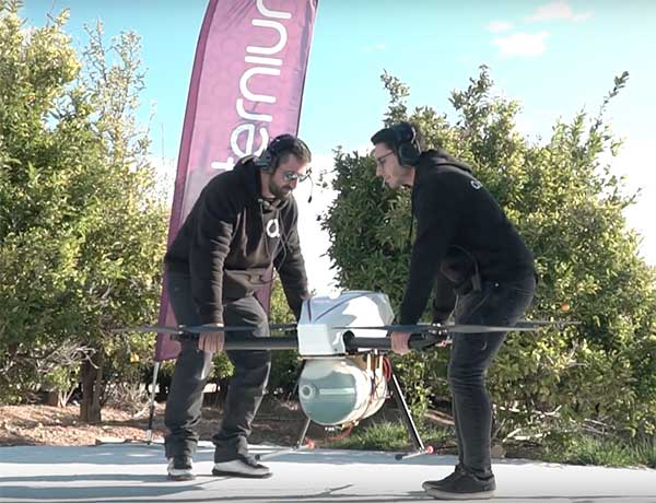
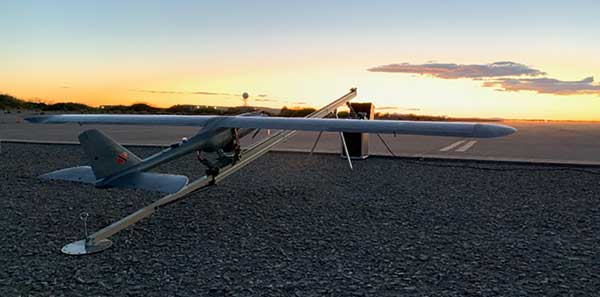
On Feb. 3, drone company Quaternium broke its own record for long flight time with a hybrid-fuel electric drone.
The Quaternium HYBRiX UAV took off at 08:52 a.m. in Valencia, Spain, and landed at 17:02 p.m., performing a stationary flight of 490 minutes.
The new endurance record of 8 hours and 10 minutes of non-stop flight time was accomplished with an experimental version of the company’s HYBRiX 2.1 drone, which carries 25 kilograms of maximum take-off weight.
Six years ago, the startup Quaternium developed its first hybrid fuel drone, inspired by hybrid cars from the automotive industry.
In 2015 the company flew its hybrid drone, the multirotor HYBRiX, for 3 hours and 10 minutes. According to the company, Hybrid multirotors multiply flight time more than 10 times compared to electric solutions.
The company has published a flight video with the demonstration of the record.
Most multicopter drones provide flight times of 25 to 40 minutes, with the pilot needing to carry multiple batteries into the field.
The HYBRiX project is supported by the European Union through its Horizon 2020 innovation program, which fosters disruptive projects in innovation, excellent science and industrial leadership. The project has received awards from institutions such as AUVSI, CDTI and the Spanish government.
The Quaternium team was motivated to develop a long-endurance drone because it will help first responders and and firefighters to identify hot spots and search for survivors in the event of a catastrophe, the company said in a press release.
A roundup of recent products in the GNSS and inertial positioning industry from the March 2020 issue of GPS World magazine.
OEM
NavIC modules
Support both L1 and L5 bands
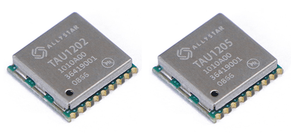
Photo: Allystar
The dual-band multi-GNSS modules TAU1202 and TAU1205 support both the L1 and L5 bands to enhance sub-meter positioning accuracy. Constellations received include GPS, Galileo, GLONASS, BeiDou, QZSS and NavIC. Besides the L1 band, TAU1202 and TAU1205 also support L5/B2a/E5a, which are expected to have lower noise and significantly reduced multipath mitigation because of the higher chipping rate of L5 signals relative to L1 C/A code. TAU1205 supports NavIC (IRNSS), improving navigation in India and the Middle East. Powered by the Cynosure III GNSS chipset and with built-in low-noise amplifier and surface acoustic wave (SAW) filter, TAU1202 and TAU1205 provide higher sensitivity, ensuring exceptional acquisition and tracking performance even in weak signal areas.
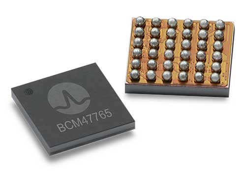
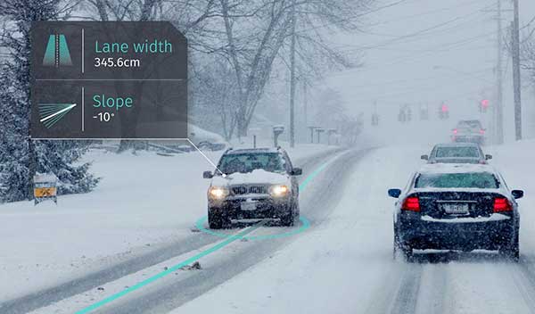
The BCM47765 dual-frequency GNSS module is capable of using the BeiDou-3 constellation’s B2a signals (the Chinese indicator for L5). It can track 30 new L5 signals (60% more) with a significant impact on accuracy. End users will experience much higher reliability of the submeter accuracy inherent to dual-frequency L1/L5. The enhanced L5 signal improves the accuracy of GNSS in an urban scenario by mitigating reflections from nearby buildings (multipath). It also improves GNSS in an open-sky scenario, allowing for submeter accuracy. Second generation dual-frequency GNSS will enable lane-level driving navigation, allowing applications to know in which highway lane a vehicle travels.
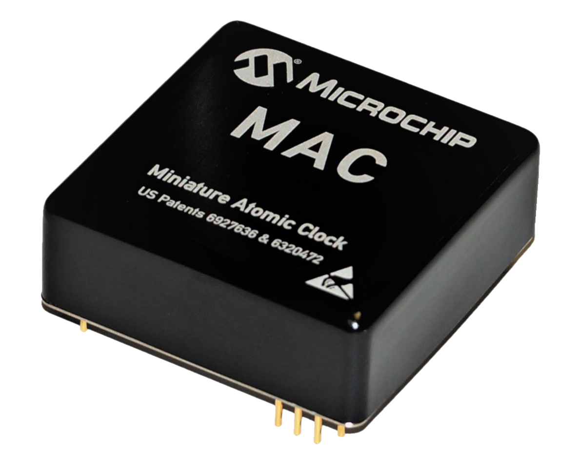
The MAC-SA5X miniaturized rubidium atomic clock is a high-performance atomic clock that delivers a wide thermal range, critical performance improvements and other enhancements over previous clocks. The MAC-SA5X produces a stable time and frequency reference that maintains a high degree of synchronization to a reference clock, such as a GNSS-derived signal. Its low monthly drift rate, short-term stability and stability during temperature changes allows the device to maintain precise frequency and timing during extended periods of holdover during GNSS outages or for applications where large rack-mounted clocks are not possible. Operating over a temperature range of –40 to +75 Celsius, the MAC-SA5X is designed to quickly achieve atomic stability performance with a fast lock.
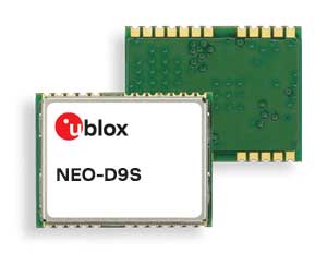
The NEO-D9S GNSS correction data receiver module provides an affordable approach to bringing centimeter-level accuracy to GNSS receivers. The NEO-D9S receives corrections from correction service providers broadcast on the L-band (1525–1559 MHz). A host processor can then decrypt this correction data and provide it to a high-precision GNSS receiver, combining corrections directly with readings from the satellite constellations to enable much more accurate position readings than those offered by GNSS signals alone. Use of the NEO-D9S will also increase the availability of high-precision GNSS positioning data in areas with limited connectivity and reduce the amount of cellular data consumed by positioning receivers. Expected customers are Tier 1 and OEM carmakers, industrial system integrators, and any other applications that rely on very accurate positioning at low cost. The NEO-D9S module is a correction-only receiver. Based on the latest u-blox ninth-generation (D9) platform, it will integrate easily with the u-blox F9 RTK GNSS receivers from u-blox, or can be used as part of a modular product roadmap.
The Qualcomm Snapdragon 720G, 662 and 460 enable enhanced user experiences across connectivity, gaming and entertainment. The new mobile platforms support dual-frequency (L1 and L5) GNSS to improve location positioning accuracy and robustness. The system-on-chip solutions also support NavIC. For the first time on mobile, the Qualcomm Location Suite supports up to seven satellite constellations concurrently, including NavIC.
Dedicated to surveying and agriculture, the UAV Birdie is tailor-made, combining intuitive use and high-quality data through precise sensors and GPS RTK L1/L2 onboard. Features include a 24-megapixel camera or optional full-frame 42-megapixel camera; flight time up to 60 minutes; and coverage up to 8 square kilometers in one flight. A vertical-takeoff-and-landing (VTOL) upgrade is available.
Skyfront’s Perimeter 8 drone is equipped with Silvus Technologies’ SteamCaster Radio system, a powerful user-customizable radio system for the military, police and broadcast. The new long-range drone will allow operators to inspect pipelines and other assets as well as conduct long-range surveillance missions. The octocopter can fly for five hours and travel up to 100 kilometers without losing connection from the ground station. Currently, five models are available to suit uses including mapping, lidar and medium, long, or extra-long surveillance. SteamCaster radio system uses the latest beam-forming technology, spatial multiplexing, and space-time coding to ensure the drone can be controlled in environments in which other radio systems are likely to fail. The combination of the technologies allows the range to be increased from 40% to 100%. SteamCaster comes with SteamScape, a network management interface to allow for key metrics and statistics to be viewed and collected in real time. The system also allows the drone to be overlayed onto a map showing the current location and path of the drone.
Delivers critical tools on the ground or in the air
Photo: Robotic Research
The Pegasus Mini is a smaller version of the Pegasus, a hybrid unmanned aircraft system/unmanned ground vehicle. The Pegasus hybrid UAS/UGV configuration delivers advanced GPS-denied mapping with fully autonomous high-speed flying and driving capabilities. Pegasus Mini is designed to provide the extra reach that a UAV or UGV alone cannot provide. Uses include inspection, rescue, rapid response, and applications that strongly benefit organizations in oil and gas, public transportation, law enforcement, public safety, and more.
The Silent Falcon E1 UAV has completed 500 hours of successful flight testing and operations. It’s maker, Silent Falcon UAS Technologies (SFUAS), is based in Albuquerque, New Mexico. The E1 solar-electric, fixed-wing UAV is noise free, emission free, and provides long-range, low-cost intelligence, surveillance and reconnaissance (ISR) capability. It has a payload capacity of 20 pounds and a ceiling of 20,000 feet above ground level. SFUAS has an application pending before the FAA for type certification of the E1. The 500-hour milestone confirms for federal regulators that it is safe and durable. Silent Falcon aircraft have operated in eight foreign countries and are not ITAR restricted.
The High Definition (HD) GNSS cloud-based solution enables mass-market devices to achieve sub-meter accuracy across the globe. HD GNSS enables lane-level navigation, augmented reality and virtual reality. It combines precise point positioning (PPP) and real-time kinematic (RTK) positioning methods, allowing for fast convergence time, high availability and global coverage. It also supports off-the-shelf mobile devices and internet of things (IoT) trackers equipped with dual-frequency chipsets.
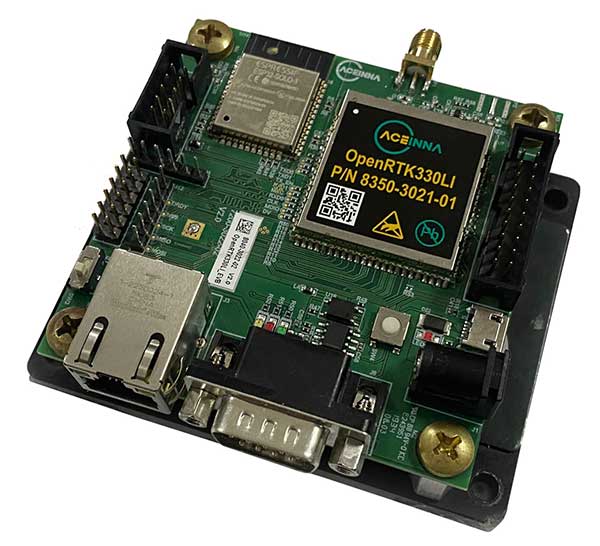
The OpenRTK330L GNSS/INS module is designed for developers creating guidance and navigation systems for autonomous vehicles, robots, drones, industrial, construction and agricultural machinery. OpenRTK330L is a low-cost, high-performance triple-band RTK/GNSS receiver coupled with redundant inertial sensor arrays to provide cm-level accuracy, enhanced reliability, and superior performance during GNSS outages. The module is aimed at automotive, robot, drone, construction and agriculture systems. The multi-band GNSS receiver can monitor all global constellations (GPS, GLONASS, BeiDou, Galileo, QZSS, NavIC, SBAS) and simultaneously track up to 80 channels. The module has RF and baseband support for the L1, L2 and L5 GPS bands and their international constellation signal equivalents.
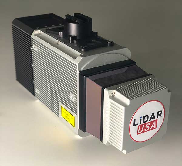
The Snoopy CL-360 lidar scanner. (Photo: Lidar USA)
The Optech CL-360 has joined the ranks of Lidar USA Snoopy systems.
The Snoopy CL-360 has been meticulously designed for integration on backpack, vehicle and UAV applications. Weighing 5 kilograms fully assembled, the Snoopy CL-360 is capable of delivering highly accurate results, up to +/-0.01 feet on paved surfaces from a vehicle.
The system has a scan line rate of 250 Hz with a 500-kHz data rate, giving a uniform result along and across track. The systems are easily configurable with multiple scanners (similar to internet of things applications) to avoid occlusions.
“We are pleased to again partner with LidarUSA in their innovative approach to UAV integration with the addition of our CL-360 to their product portfolio. Featuring true 360-degree scanning without blind spots, CL-360 integrated by LidarUSA will provide an exciting addition to the UAV marketplace,” said Optech Executive Vice President and General Manager Michel Stanier.
Users can also benefit from a UAV deployment, achieving scans with usable data as much as 60 degrees off nadir (widths of more than 1,100 feet while scanning at the 400-foot ceiling). The small beam size of 0.3 mrad allows the CL-series to reliably collect ground points (such as on or near the dirt through vegetation) while also providing better detection of fine linear features such as power lines and railroad tracks.
The integration of the CL-360 into the Snoopy series of systems from Lidar USA is expected to be a huge plus to the mapping community in 2020, according to Lidar USA. Users can expect to see the benefit of decreased field-collection effort and increased product quality resulting in a growing and profitable business.
“As more technologies embrace lidar collection to reduce their field time, we expect to see the CL-series become the ‘go to’ solution for many of them,” said Jeff Fagerman of Lidar USA. “The CL-series provides the accuracy and point density often necessary to meet the client’s every growing demands for more, more, more. By designing the system for car and UAV, as well as multiple configurations (two or more systems running together), our users will greatly benefit where they feel it most — the bank.”
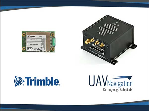
UAV Navigation’s flight control solutions for remotely piloted air systems/unmanned aerial vehicles (RPAS/UAVs) are compatible with the Trimble UAS1 high-precision GNSS receiver. The core benefits of Trimble’s GNSS solution include centimeter-level precision and easy integration.
Image: UAV Navigation and Trimble
The light, small Trimble UAS1 receiver is less vulnerable to vibrations or temperature fluctuations, making it suitable for UAVs and RPAS. In addition, the receiver can provide real-time kinematic (RTK) positioning using a base station, enabling users to achieve higher precision for their projects.
Most UAV missions demand precision in its subsystems. The Trimble UAS1 receiver meets these requirements and includes a 336-channel high-precision GNSS engine. It tracks L1/L2 frequencies from the GPS, GLONASS, Galileo and BeiDou constellations.
The Trimble UAS1 supports OmniSTAR and Trimble CenterPoint RTX GNSS corrections, which enable precise and robust positioning without the use of a base station via a subscription service. The receiver also offers an industry-standard camera hot-shoe interface and a wide DC voltage range to work in a broad range of UAVs.
While Trimble is highly specialized in providing advanced GNSS solutions, UAV Navigation’s focus is on innovations in flight control systems. With this combined technology, current UAV/RPAS systems can now operate in more demanding environments and deliver higher precision through better navigation, UAV Navigation stated in a press release.
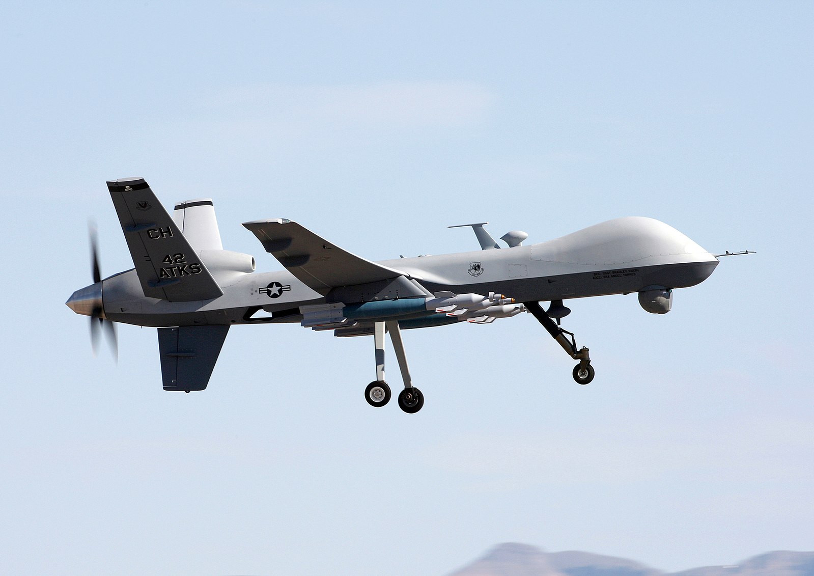
The MQ-9 Reaper drone. (Photo: U.S. Air Force/Paul Ridgeway)
A small aircraft’s encounter with a likely military drone near Edwards Air Force Base resulted in navigation failure, according to a report filed with NASA’s Aviation Safety Reporting System.
In October 2019, a single engine Piper P-46 Malibu was flying at 24,000 feet 36 miles north of Los Angeles en route San Diego.
Defense drone overhead
The pilot reported, “I saw a DOD drone (inverted V tail) pass overhead approximately 1,000 [feet] above. At the same time, my PFD [primary flight display] indicated that I had a large magnetic variation error, and in turn … indicated that I was now flying to a new way point (TCH VOR) located in Utah, well off my flight plan.”
Later, the navigation system indicated that the aircraft was on its way to a spot in Montana.
Interestingly, the flight plan displayed by another cockpit instrument, the Multi-Function Display, was not affected.
The aircraft had been operating under an Instrument Flight Plan. Federal Aviation Administration rules for light aircraft allow such operation with GPS as the sole navigation sensor.
With the primary flight display not operating properly, the aircraft was no longer able to fly a safe instrument approach to landing. Fortunately, the weather was such that it could proceed and land using Visual Flight Rules.
In the pilot’s words, “Had it not been a VMC [visual meteorological conditions] day allowing me to fly a visual approach, I would have had to [advise Air Traffic Control] – and find a way to land without any reliable approach capability.”
A combination of factors
The general consensus among experts is that this incident was inadvertent and likely arose from a combination of factors. Most significant were that the drone flew above the light aircraft, temporarily blocking some GPS signals, and emitting electromagnetic radiation from one or more of its on-board systems.
It is not possible to say what those systems and radiation may have been. It is unlikely they were intended to interfere with GPS reception, as that would pose serious safety-of-flight concerns in the nearby congested Los Angeles airspace.
GPS signals are infamously easy to disrupt, though. It is probable that the close proximity of the drone resulted in some radiation from its systems “spilling over” into GPS frequencies and causing the problem.
Of greater concern is that the light aircraft’s systems did not quickly reset and recover once the drone had moved off and the interference ceased. Had the aircraft been flying in the clouds or bad weather, the loss of its only radionavigation source could have been quite serious.
While not clear from the report, it is likely that the navigation system only recovered after a complete shutdown and restart. From the report in the NASA database:
“The system has since been checked and is operating correctly, but it seems pretty clear this was some type of interference / jamming arising from the DOD drone. Clearly, this is a significant risk to all aircraft, and because if [sic] occurred within the LA airspace it is a serious threat to safe flights.”
The need to address interference
Shortly before this incident, the International Civil Aviation Organization identified addressing interference with satellite navigation system signals an “urgent priority.” This was in response to concerns from several member countries and organizations citing safety of flight issues. One example cited was the near loss of a passenger aircraft flying in the mountains during a period of GPS disruption.
The October 2019 report of interference from the drone is number ACN 1696794 in the NASA Aviation Safety Reporting System. It can be accessed by searching here.
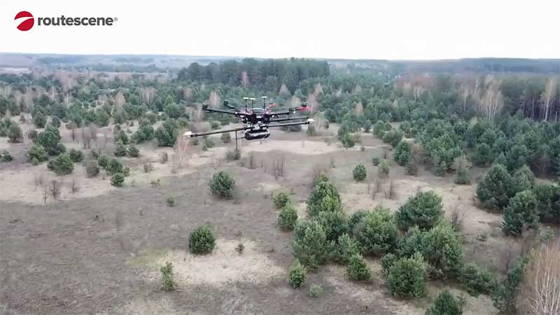
Professor Tom Scott, from the School of Physics at the University of Bristol, U.K., led a group of researchers from NCNR to conduct surveys on multiple sites of interest, including the Buriakivka village, a settlement abandoned following contamination from the power plant accident, and the “Red Forest,” a natural woodland area located the closest to the reactor.
Working closely with local Ukrainian authorities, the team operated unmanned aerial vehicles (UAVs) — Routescene’s LidarPods flown on DJI M600 hexacopter drones — to perform a series of radiation mapping surveys over the course of 10 days.
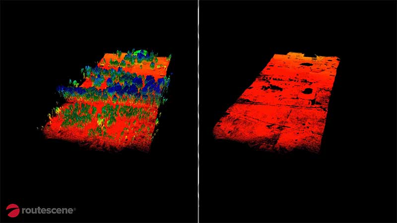
According to Routescene, the point cloud data collected was processing using its LidarViewer Pro software to generate a detailed digital terrain model. It was then overlaid with the results from a gamma spectrometer survey, undertaken to measure radiation intensity, to locate the exact sites of the radiation hotspots.
“The algorithm converts the aerial radiation intensity recorded by a UAV survey into a ground intensity map,” said Kieran Wood, senior research associate at the University of Bristol. “This process is heavily affected by the distance between the airborne radiation sensor and the ground/buildings. Hence, high accuracy lidar-based models were essential.”
Photo: Routescene
Results
While the general widespread radiation contamination in the Red Forest was already known, the results revealed that the radioactivity was unevenly disturbed. Although radiation intensity had reduced in some areas, other areas remain highly contaminated confirming continued danger to anyone accessing those areas, Routescene reported.
In addition, the researchers detected one unexpected hotspot in the ruins of a facility that was used to separate contaminated waste during clean-up efforts immediately after the accident.
This expedition was the first in a series of surveys NCNR will conduct in Ukraine over the next year. The new maps will help officials prevent risks to visitors to the area and the full results will be published soon, Routescene said.
Phase One Industrial, a provider of medium-format metric cameras and imaging solutions for aerial applications, has signed an agreement with AI-Survey GmbH, a developer of UAS survey packages, services and tailor-made solutions.
Together, the companies’ high-end products are opening up opportunities in drone-based high-accuracy mapping and inspection markets, the companies said.
Under this agreement, AI-Survey will support Phase One Industrial’s iXM range of cameras in the UAV market for high-accuracy mapping and inspection. AI-Survey offers fast and efficient, simple and reliable UAS solutions tailored for geodesists with millimetre imaging results.
“Our cameras exemplify AI-Survey’s mission to optimize, increase efficiency and inspire UAV mapping and inspection missions,”said Dov Kalinski, CEO, Phase One Industrial. “As an industry leader, we are confident that they will help our strategic efforts to evolve the industry through innovative solutions using Phase One Industrial technology.”
“We have developed long-term relationships and collaborations with many global technology partners, like Phase One Industrial,” said Carsten Rudolph, managing director, AI-Survey explains. “As an independent solutions provider, with such a large international network at our disposal, we are free to offer the best possible solutions to meet our customer needs and achieve their required accuracies. With Phase One iXM cameras, we now have the best global sensor for UAV mapping available, we believe.”
A proposed FAA rule — open for public comment until March 2 — would require drones over 0.55 pounds to electronically transmit their location and ID.
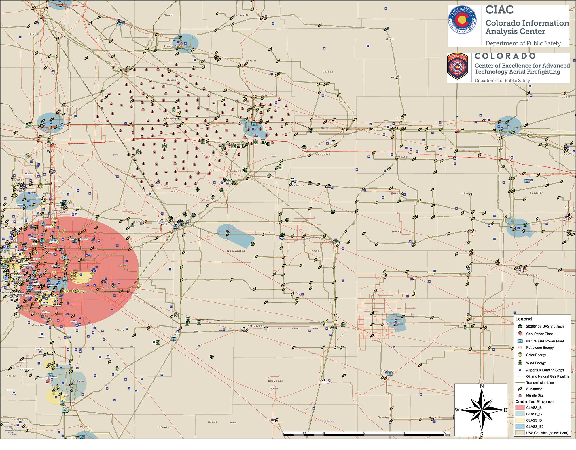
Northeastern Colorado was visited with a mystery in late December and January. Residents began seeing drones from 7 to 10 p.m. each night, moving in groups as large as 30, and flying in a grid pattern. The drones stayed about 200 feet to 300 feet in the air and flew steadily in squares of about 25 miles, at speeds estimated at 25–40 mph.
Reports were so numerous that a multi-agency task force was formed to investigate, including 10–15 law enforcement agencies as well as the FBI and Federal Aviation Administration (FAA). The drones were reported to measure six feet across and sound like a small jet engine. “These are not drones that people in our county can just buy,” said Washington County Sheriff Jon Stivers.
Numerous government agencies and companies denied the drones were theirs, including the U.S. Air Force, NOAA, NORAD, the FAA, and large drone developers Google, Amazon and Uber.
The Colorado Division of Fire Prevention and Control (DFPC) flew the state’s Multi-Mission Aircraft in an area where drones had been reported during two January missions.
This DFPC map, obtained by FOX31 TV, shows possible locations of drone sightings along with power plants, pipelines and missile sites. (Map: Colorado Division of Fire Prevention and Control)
Some suspect the drones were part of a secretive Air Force counter-drone program to protect nuclear missile silos. Another theory was a hunt for a missing nuclear warhead from one of the many intercontinental ballistic missile sites that dot the prairies of Wyoming, Colorado and Nebraska.
A group of Wichita, Kansas, drone enthusiasts also came forward, saying they had flown groups of drones in the area — but not to the same scale.
In an interview at January’s World Economic Forum in Davos, Switzerland, Transportation Secretary Elaine Chao told Yahoo Finance, “We don’t know who they belong to, we don’t know who’s operating them, to this day we do not.” Her department oversees the FAA, which issues Part 107 waivers to drone operators, allowing them to fly at night or out of line of sight of the operator. The waivers (thousands have been issued) lack enough specifics to narrow down who might be responsible for mystery drones.
A proposed FAA rule — open for public comment until March 2 — would require drones over 0.55 pounds to electronically transmit their location and ID, giving agencies access to information on drones in flight.
The new remote ID requirement would help with the creation of the Unmanned Aircraft System Traffic Management System, a project between the FAA, NASA and other agencies to “ultimately identify services, roles and responsibilities, information architecture, data exchange protocols, software functions, infrastructure, and performance requirements for enabling the management of low-altitude uncontrolled drone operations,” according to the FAA.
As of press time, no one has come forward to claim ownership of the drones. The public is encouraged to submit reports. As The X-Files’ Fox Mulder might say, “Watch the skies.”
The contract begins the offering for the purchase of complete drone solutions to all state agencies, commissions, political subdivisions, institutions and local public bodies allowed by law.
DroneUp is an end-to-end drone pilot service provider for aerial data collection. In August 2019, the company was awarded the Unmanned Aerial Systems (UAS) Services Master Agreement #E194-79435 by the Commonwealth of Virginia.
The services under this latest award (Contract Number #2020DRONE0002) are available for use by all 50 states, the District of Columbia, and the territories of the United States through the National Association of State Procurement Officials (NASPO) ValuePoint Cooperative Purchasing Organization.
The State of Alaska is now able to use the award for the benefit of state departments, institutions, agencies, political subdivisions, and other eligible entities.
DroneUp’s award includes but is not limited to service categories for
Emergency Support Services,
Law Enforcement Support,
Aerial Inspection or Mapping Data Services,
Agricultural and Gaming, and
Agency Media Relations and Marketing.
Primary users are expected to be
Agriculture & Game Management,
Emergency Management,
Transportation,
Forestry,
Mines,
Minerals and Energy, and
Public Universities and Community Colleges.
“We appreciate the efforts to streamline public sector access to leading-edge UAS services through the contract with the State of Alaska, and we look forward to supporting our hardworking state and local agencies,” said Tom Walker, DroneUp’s CEO.
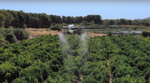
The use of drones for precision agriculture is gaining momentum because of their capability to deliver the most updated information fast and efficiently. UAVs are transforming how agriculture is done. By implementing drone technology, farms and agriculture businesses can improve crop profit, save time, and make land-management decisions that improves long-term success.
A few weeks ago Quaternium tested its innovative HYBRiX drone to spray fertilizers in the orange fields near Valencia, Spain. With its system of longer-than-average flight-duration, farmers have the opportunity to monitor and spray their fields precisely and rapidly.
“I am really glad to see that the entire spraying process in my orange fields has hardly taken six hours,” said farmer Pedro Andreu while operating the HYBRiX. “With other drones, we had to spend multiple hours waiting for batteries to charge and days to finish the work.”
The test convinced Andreu to use the technology to simplify his work. He engaged farmers in the neighborhood to join him and implement this technology in their work as well.
Alicia Fuentes, Quaternium CEO, accompanied the team for the field demonstration. She noted that farmers could benefit by using precision farming technology in a variety of ways: monitoring the health of their crops, estimating soil conditions, planting future crops, fighting infections and pests, updating the health of plants, and livestock monitoring.
Hybrid fuel system. HYBRiX UAS operates using a hybrid electric-fuel system. This makes it easy to operate the multi-rotor drone through the fields of a farm for an entire work whole day by refilling the spraying tank when needed and the fuel tank every 2-3 hours. Its built-in capacity of 5 liters of fuel enables HYBRiX to surpass the flying time from minutes to 2 to 4 hours.
The powerful propulsion system of HYBRiX allows the aircraft to carry up to 10 liters of liquid, with a maximum takeoff weight of 25 kg. The combination of hybrid power with its increased range extender capacity allows the farmer to cover large acres of land without carrying uncomfortable batteries and ensure long flight time in the field with the aircraft.
Quaternium is now focused on refining this technology to extend crop protection across the country so that farmers can benefit from the outcome to make their work more efficient.
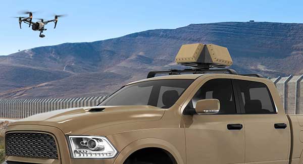
DroneShield has released a vehicle-mounted drone detection and defeat product, DroneSentry-X.
Lightweight at about 10 kilograms, it can be easily mounted on most vehicles. DroneShield expects the product to be of interest to military, law enforcement, security and VIP the markets. The product is suitable for both vehicle/convoy and fixed site installations. The product was developed in response to substantial customer interest, according to the company.
“Vehicle market for counterdrone protection is rapidly rising,” said DroneShield’s CEO Oleg Vornik. “In addition to catering for that segment, DroneSentry-X provides a more affordable detect-and-defeat solution for price-sensitive customers as an alternative to purchasing full-functionality DroneSentry product from us. DroneShield offers a complete suite of detection and defeat solutions to our customers, and this new product covers the customer need which we identified in our recent engagements.”
Earlier this year, a drone pilot and two data scientists from PrecisionHawk traveled to the Philippines for a unique mission — to fly drones equipped with lidar sensors over a dense rainforest to map ancient trade paths. The aim was to find buried treasure left by the Japanese during World War II.
PrecisionHawk was approached by the producers of a new History Channel show to help them navigate the Filipino rainforests. Through the combination of air and ground sensors, including a DJI M600 UAV equipped with a Riegl miniVUX lidar sensor and a Sony a6000 camera, PrecisionHawk staff produced a colorized 3D map of the forest.
The History Channel aired the series premiere of “Lost Gold of World War II” on March 19, 2019; all eight episodes are now available for streaming. The second episode features visuals generated by PrecisionHawk, as well as interviews with the drone pilot and data scientists.