The M.A.D.S. radomes track drones at the port, so they can be identified as beneficial or a threat. (Photo: Martek)
The Port of Amsterdam has begun a four-week trial of a drone detection system. Martek Anti-Drone Systems is providing its M.A.D.S. (Marine Anti-Drone System) to build understanding of how, where and why drones are flying over the Port of Amsterdam.
The M.A.D.S system will support the port by monitoring legal and illegal flying across its land. The system detects and identifies drones within a 5-kilometer range, providing GPS positioning of both drone and pilot together with the drone’s speed and heading.
Configurable and escalating stage alarms in real time allow the drones’ intentions to be assessed in time to decide on appropriate defense actions.
M.A.D.S. radomes are installed around the Port of Amsterdam. (Photo: Martek)
The data collected from the trial will have far-reaching influence on the future use of UAVs (unmanned aerial vehicles) across the 650-hectare port area, according to Martek.
The port has identified the potential of drones for numerous use applications across its operations and its customers’ operations. Many port customers are preparing to use drones for infrastructure inspection and measurement of environmental parameters. The trial will monitor their use.
Project manager of innovation Joost Zuidema is overseeing the trial for the Port Authority. “This trial is an important part of our innovation strategy,” Zuidema said. “The M.A.D.S system gives us a first opportunity to get a feeling for the technology that will help us understand drone usage and make a first assessment on unwanted drone flights in a part of our port.”
Like any tool, drones are being used for good as well as malevolent purposes. There is a potential threat to transport such as container ships and major infrastructure, such as ports, around the world. Threats include:
privacy invasion
terrorism threats of explosives or gas attack
flyby hacking to take control of autonomous or semi-autonomous systems
stealing valuable data off unprotected networks or breaking into insecure networks
Infographic: Martek:
“As the Port Authority, we do want ensure drone flights in our port are carried out safely and responsibly, within the laws and regulations,” Zuidema said.
“The growing trend for the use of UAVs being used on ports, commercial shipping and super yachts is, as yet, not fully recognised by authorities,” said Erik Van Wilsum, Martek. “We are delighted to be working with Port of Amsterdam, who are on the cutting edge of developing technology to understand the opportunities for drone use and the potential threats and benefits they can provide for key national infrastructure.”
A report by International Data Corporation stated that it expected worldwide investment in drones to be US$12.3 billion in 2019, with drone purchase growing nearly twice as fast as the investment in robotics over the same period.
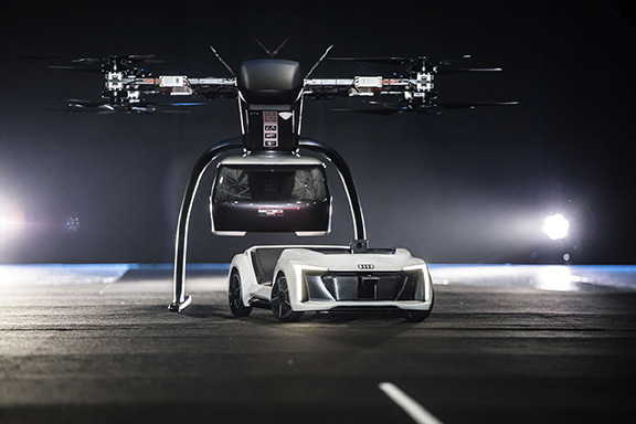
Audi, Airbus and Italdesign presented for the first time a flying and driving prototype of Pop.Up Next, a flying taxi. The companies demonstrated the concept at Drone Week, held Nov. 27-29 in Amsterdam.
The concept combines a self-driving electric car with a passenger drone. In the first public test flight, the flight module accurately placed a passenger capsule on the ground module, which then drove from the test grounds autonomously.
Photo: Audi
The demonstration was done with a 1:4 scale model. But as soon as the coming decade, Audi customers could use the flying taxi service in large cities — in multi-modal operation, in the air and on the road, without changing vehicles.
“Flying taxis are on the way. We at Audi are convinced of that,” said Bernd Martens, Audi board member for sourcing and IT and president of the Audi subsidiary Italdesign. “More and more people are moving to cities. And more and more people will be mobile thanks to automation. In future senior citizens, children, and people without a driver’s license will want to use convenient robot taxis. If we succeed in making a smart allocation of traffic between roads and airspace, people and cities can benefit in equal measure.”
To see what an on-demand service of this kind could be like, Audi is conducting tests in South America in cooperation with the Airbus subsidiary Voom. Customers book helicopter flights in Mexico City or Sao Paulo, while an Audi is at the ready for the journey to or from the landing site.
“Services like this help us to understand our customers’ needs better,” Martens said. “Because in the future, flying taxis will appeal to a wide range of city dwellers. With Pop.Up Next we are simultaneously exploring the boundaries of what is technically possible. The next step is for a full-size prototype to fly and drive.”
Audi is also supporting the Urban Air Mobility flying taxi project in Ingolstadt. This initiative is preparing test operations for a flying taxi at Audi’s site, and is part of a joint project of the European Union in the framework of the marketplace for the European Innovation Partnership on Smart Cities and Communities.
The project aims to convince the public of the benefits of the new technology and answer questions concerning battery technology, regulation, certification and infrastructure.
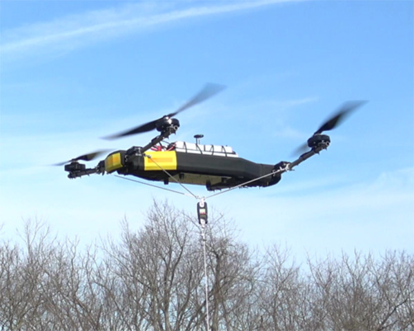
Mobile Recon Systems is offering an unmanned aerial vehicle that can lift more than its own weight.
At 78 pounds, the Dauntless multi-rotor UAV has lifted an additional payload of 100 pounds as a tethered quadcopter, the company said. It is designed to lift more than 200 pounds as an octocopter, with a generator-powered flight time of several hours.
Photo: Mobile Recon Systems
“Drones have proven to be great for videography. But uses beyond that have been limited by low lift capacity, limited flight time and narrow functional capability,” said Mobile Recon Systems founder Mike Dowell. “With the Dauntless, that is no longer the case.”
Not only can the Dauntless carry up to 160 pounds of supplies in a climate-controlled transport box, it is a multi-functional platform. It can be outfitted with sensors, radiation detectors, radar, weather stations, multi-spectral, thermal and infrared cameras, and other devices. It can perform eight or more different functions at once. Plus, users can easily swap or combine devices to meet their needs.
Those capabilities enable this model to deliver high value services previously out of reach for UAVs, the company said.
“The Dauntless is ideal for border and perimeter security, as well as natural disaster response, medical emergency first response, routine inspections and aerial analysis, and mapping,” Dowell said. “With its lift capacity, it can carry high-end lidar and cameras, as well as supplies. Our flexible platform offers a myriad of possibilities.”
To illustrate, the Dauntless can carry an MSOP and four multi-axis gimbals, mounted on top and bottom, to accommodate optical, thermal and multispectral cameras, including a RED Epic. high-end digital camera. These can simultaneously capture multiple types of images from below, front, overhead, right and left of the flying platform.
The Dauntless has a full 3K (military-grade) carbon-fiber body and titanium and aircraft aluminum frame. The propellers are carbon fiber, and are safely surrounded by the body. It is waterproof and sandproof.
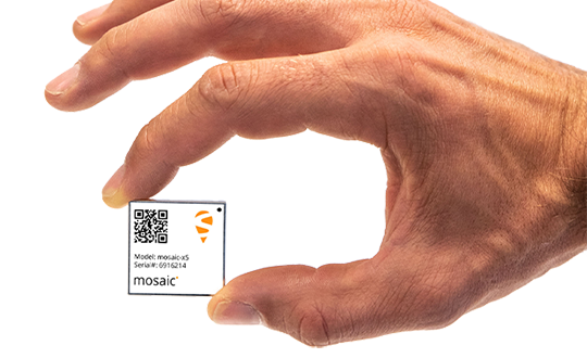
Septentrio has launched the Mosaic high-precision GNSS receiver module.
Despite its compact size (31 x 31 x 4 millimeters, 1.29 x 1.29 x 0.15 inches), the Mosaic module supports more than 30 signals from all six GNSS constellations, L-band and various satellite-based augmentation systems, the company said.
As a multi-band module tracking all GNSS satellites in view, it is also designed to support future GNSS signals.
It also supports correction services, and uses real-time kinematic (RTK) technology, together with Septentrio’s algorithms, to guarantee maximum accuracy and availability. The surface-mount design of Mosaic is optimized for automated assembly and ease of integration, with a full library of well-documented and flexible interfaces.
“Our new Mosaic module represents the best-in-class option for reliable and scalable position accuracy, with integrity,” said Chris Lowet, product manager at Septentrio. According to Lowet, it provides RTK positioning with a power consumption of 0.6-1 W, and requires no or minimal additional components for the design-in. “These characteristics make it an ideal positioning cornerstone for a variety of mass market UAV, autonomous and robotics applications,” Lowet said.
Photo: Septentrio
Robustness to interference. Due to the natural weaknesses of distant GNSS signals and a crowded radio-frequency spectrum, GNSS-based services are vulnerable to unintentional radio-frequency interference (RFI). They are also vulnerable to intentional RFI, attacks intended to disrupt receivers by means of counterfeit GNSS-like signals (known as spoofing), and to intentional transmission of RF energy to mask GNSS signals with noise (known as jamming).
To defend against these threats, Mosaic features Septentrio’s AIM+ technology. AIM+ can suppress the widest variety of interferers, from simple continuous narrowband signals to complex wideband and pulsed jammers, the company added. In addition, the integrated spectrum analyzer allows the RF environment around any Mosaic module to be viewed in real time in both time and frequency domains.
Effective interference countermeasures against threats to GNSS signals also require constant knowledge of the changing RF environment. The Mosaic module helps analyze these threats by continuously and automatically monitoring the GNSS frequency spectrum to detect, characterize, log and mitigate interference events when needed.
Exploring a wide area in search of a hazardous substance emitting source or expansion of a fire front is an ideal UAV mission. Wildfire monitoring missions exemplify such a problem.
Most multi-UAV systems address problems related to search in an environment of interest. The UAVs cooperate and share data to obtain information within a certain aspect of the environment.
Regardless of the number of UAVs and size of the area of interest (AOI), cooperative systems deliver a perfectly up-to-date picture of the environment with coordination.
This paper investigates a coordination scheme for missions facing uncertainty about the periphery in the AOI. It takes into account the UAVs’ state, observations, the overall mission, and allocates each UAV to a specific task, enabling the multi-UAV system to act in a coordinated manner.
If a coordination algorithm for an environment with uncertainty is available, the overall system still leans on sensing capabilities. Even if the system uses the most advanced sensors, sometimes the environmental conditions are restrictive; that is, UAV sensors cannot reach far enough, and measured data can only be local and quantized data.
The goal of quantized estimation is to develop techniques to effectively reconstruct the data. The research approach relies on a technique for estimation of propagated boundary with quantized measurements and proposes a new class of one-dimensional estimator: the Greedy Uncertainty Suppression (GUS) strategy.
The monitoring application involves large numbers of possibly randomly distributed inexpensive sensors, with limited sensing and processing. The estimator incorporates observations gathered by multiple observers and uses the quantized kalman filter estimation to update the expected location and unobserved spreadrate.
A roundup of recent products in the GNSS and inertial positioning industry from the December 2018 issue of GPS World magazine.
OEM
Combination antenna
Long-range connectivity
Photo: Molex
The Molex highly compact 2.4/5-GHz combination GPS/Wi-Fi ceramic antenna is designed to be a cost-competitive solution covering the full GNSS band, 1.561 to 5.85 GHz. The triple-band ceramic antenna has Wi-Fi HaLow compatibility and is interference-resistant, supporting larger but lower (900-MHz) frequency ranges than 2.4/5-GHz connections. It also operates with lower power over longer ranges than 2.4/5-GHz Wi-Fi. Advanced Wi-Fi applications the internet of things, connected cars, smart homes and smart cities.
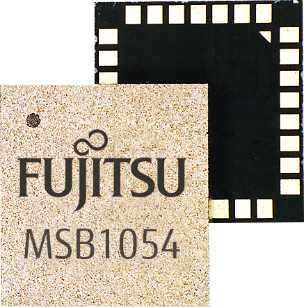
The MSB1054 multi-receiver module requires no external components, meeting needs of smartwatches, fitness trackers, logistics and navigation. Its Flash memory saves navigation data to optimize performance and provide a hot start. The ability to receive signals from several satellite systems significantly reduces the time to first fix. The module provides a built-in RF-front end (SAW filter, low-noise amplifier) as well as a temperature-compensated crystal oscillator (TCXO), so no external component is required other than an antenna. It measures 5.8 × 6.2 × 1 millimeters and uses 3.4 mA current in low-power mode, such as for tracking.
The GE310-GNSS is an internet of things (IoT) module with GSM/GPRS, multi-constellation satellite positioning and Bluetooth functionality in a 270-millimeter-squared form factor. It meets European demand for GSM/GPRS compact form factors and is part of Telit’s migration-support program that helps customers leverage 2G’s low cost and broad coverage while preparing for 4G and 5G. The GE310 enables OEMs and system integrators in asset management, utilities and telematics to meet the strong demand for low-cost, highly compact devices without tradeoffs in performance, reliability and functionality, particularly in regional markets such as Europe, where 2G is forecast to remain in strong growth in number of IoT connections for many years.
With multi-sensor fusion positioning and orientation
Photo: Unicore
The CLAP-B multi-GNSS/MEMS integrated inertial navigation board features a miniaturized high-performance inertial measurement unit (IMU) on a compact high-performance GNSS board. The high-accuracy GNSS positioning coupled with a high-precision gyro and accelerometer provides stable, continuous 3D position, velocity and attitude, as well as original acceleration and angular velocity measurements, even in GNSS-denied environments. CLAP (Concurrent Localization & Attitude Pilot) technology is a high-precision multi-sensor fusion positioning and orientation technology developed by Unicore. The board is compact, light weight and has low power consumption. It is designed for ease of integration and mass production, and is suitable for autonomous driving, smart surveying and UAVs.
The UNI-GR1 RTK GNSS receiver offers highly accurate heading and positioning output. It can be connected to any device through Wi-Fi, mobile data, radio, USB or serial cable. It simultaneously tracks GPS L1/L2/L5, GLONASS L1/L2, Galileo E1/E5a/E5b and Beidou B1/B2/B3 on 432 channels. The receiver has a built-in level, a LED ring driven by a nine-degrees-of-freedom inertial measurement unit. Users can configure numerous settings such as real-time kinematic, or begin surveying immediately with a smartphone or laptop.
Dynamic tilt functionality has been added to the Trimble SPS986 GNSS smart antenna. The dynamic tilt upgrade allows for faster data collection to enable construction surveyors to create larger digital terrain models faster and with improved accuracy. It can capture higher accuracy measurements on steeper slopes from a moving vehicle and more accurate volume measurements to save time and money on material planning. The dynamic tilt measurement mode also auto-measures antenna height. From inside the vehicle, contractors can set the height of the antenna and quickly interrogate surface models using the real-time 3D surface display in Trimble Siteworks field software.
The Skycatch Edge1 is an on-premise data processing and GNSS base station optimized for the Skycatch Explore1 and DJI Phantom 4 RTK drones. Field teams can fly a drone, process the data and receive centimeter-level data output in 30 minutes or less, directly to a tablet, without the need for internet or cellular connectivity. 2D maps and 3D point clouds can be shared from the tablet. The Edge1 includes built-in WiFi, LTE and reliable sub-5-centimeter accuracy, and delivers high-quality data output. It is also capable of running deep learning algorithms to extract more insights from collected data in near real time.
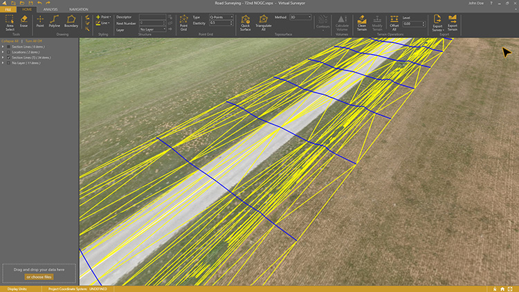
Drone surveying software Virtual Surveyor now eliminates the need for clients to use third-party applications to prepare data for processing. Version 6.1 handles on-the-fly projections that previously required a separate software package to set the data in the proper coordinate system. It bridges the gap between UAV photogrammetric processing applications and engineering computer-aided design (CAD) packages. The software generates an interactive onscreen environment with UAV orthophotos and digital surface models where the surveyor selects survey points and breaklines to define the topography, creating highly accurate topographic products for CAD input up to five times faster than otherwise possible. Surveyors can drag and drop all kinds of files into Virtual Surveyor: points, raster, vectors and point clouds. The point clouds are converted to a DSM for manipulation and processing, dramatically accelerating the time required to generate the CAD model.
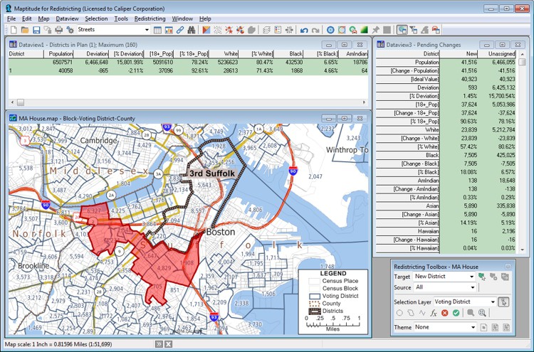
Includes Efficiency Gap Measure to explore redistricting problems
Screenshot: Mapitude
Maptitude for Redistricting is a professional tool for political redistricting. Maptitude provides measures and reports that support the creation of fair and balanced districts, and regularly enhances the software. Maptitude was used to democratize redistricting in California and is used by redistricters from independent commissions, non-profits, and civil rights groups, to the courts and political parties.
Stockpile measurements are up to 80% more accurate
Photo: DJI
The DJI Mavic 2 Pro drone is now part of the Kespry stockpile measurement solution for mining and aggregates companies. Kespry’s stockpile measurement solution produces data up to 80% more accurate than manual measurement. All of the survey data is stored in a central cloud application, accessible for analysis by the entire team. Large aggregates and mining companies can standardize and capture stockpile data across all their sites in the Kespry platform, while using Kespry 2s or DJI Mavic 2 Pro drones.
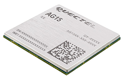
Designed for next-generation automotive applications
Image: Quectel
The automotive-grade C-V2X module AG15 features the Qualcomm 9150 C-V2X chipset paired with Quectel LTE module AG35. It is designed to meet the telematics and vehicle-to-everything (V2X) connectivity requirements of autonomous driving and road safety. It features a built-in multi-constellation high-precision GNSS (GPS/GLONASS/BeiDou/Galileo/QZSS) receiver with additional support from satellite-based augmentation systems (SBAS) and Qualcomm 3D dead-reckoning technology, which improves positioning accuracy and speed while simplifying customer designs. It is designed to allow low-latency, highly reliable and highly dense data exchange between vehicles and their surroundings, enabling effective information sharing among road users to avoid collisions, thus improving automotive safety, automated driving and traffic efficiency.
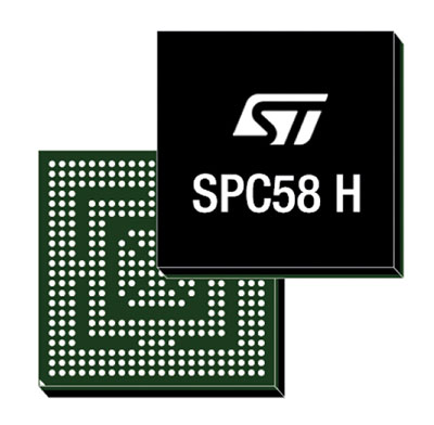
The SPC58 Chorus H microcontroller (MCU) line can run multiple applications concurrently to allow more flexible and cost-effective vehicle electronics architectures. The line is designed for high-end body, networking and security applications such as gateways, body-control modules, battery management and ADAS safety systems. The line has three high-performance processor cores, more than 1.2-MB RAM and powerful on-chip peripherals. The MCU securely delivers updates over the air for vehicle powertrain, body, chassis and infotainment features. With high security and large on-chip code storage, ST’s Chorus automotive microcontroller is a gateway/domain-controller chip capable of handling major OTA updates securely. Two independent Ethernet ports provide high-speed connectivity between multiple Chorus chips throughout the vehicle and enable responsive in-vehicle diagnostics.
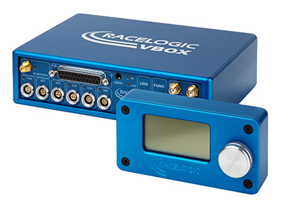
The VBOX 3i RTK is a real-time-kinematic-enabled version of the VBOX 3i dual antenna that can be used in conjunction with an RTK differential base station to obtain ±2-centimeter positional accuracy in real time at 100 Hz. The data logger combines the advantages of a twin antenna GPS setup with GLONASS satellite tracking. It can be used in vehicle tests where positional accuracy and repeatability are of key importance, such as lane departure testing, distance to a fixed object or precise mapping. The VBOX 3i RTK comes with the VBOX manager, a display enabling users to change dynamic modes and filter settings, set up slip angle data and define antenna locations.
The StarLink TrackerWi‑Fi advanced vehicle-tracking device combines u-blox GNSS, 4G and Wi-Fi technology, eliminating the need to equip vehicles with a separate mobile Wi‑Fi hotspot. StartLink is suitable for applications for connected cars, telematics, vehicle diagnostics, fleet management, vehicle security, usage-based insurance, and rental and leasing service companies. With the Wi‑Fi hotspot, users can tap into cellular 4G to transfer telematics data to the fleet manager and send real-time data to the driver’s smart device or infotainment system.
The Notilo Plus team with the iBubble. (Photo: Notilo Plus)
Notilo Plus has launched iBubble, a fully wireless, autonomous and intelligent underwater drone that can be used for search-and-rescue operations, naval or underwater infrastructure maintenance, and subsea patroling. iBubble can accompany divers for up to an hour and down to 197 feet depth, enabling superior underwater imaging. The remotely operated vehicle (ROV) was designed using a patented underwater localization technology, which is mainly based on acoustic signal transmission and image recognition (video tracking). By combining these technologies, iBubble is able to locate precisely its target underwater and shoot stable footage. The iBubble is equipped with an obstacle avoidance system, real-time image recognition, a stabilization system and direct surface control.
Anafi Work is an ultra compact tool for professionals, helping them make informed decisions using the drone’s aerial insights. Anafi Work includes the advanced Anafi drone equipped with an innovative imaging system, a 4K/21MP camera with a 180° vertical orientation, allowing users to capture images of inaccessible areas.The drone operates for 1 hour and 40 minutes with its 4 USB-C smart batteries. It can be transported anywhere in a compact shoulder bag. Professionals can create 3D models of buildings, quickly and easily, using a one-year subscription to Pix4Dmodel.
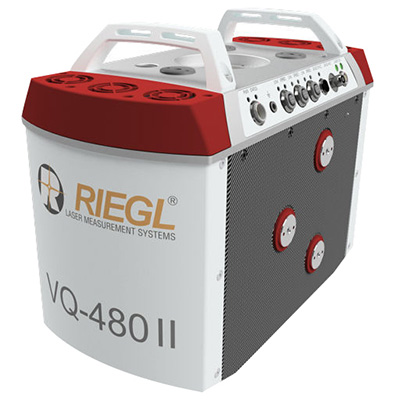
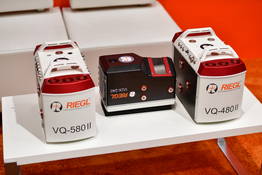
The Riegl VQ-480 II and VQ-580 II are designed for airborne applications at mid-altitudes for use on both manned and unmanned aircraft. The new Mark 2 designs of previous models improve both performance and user-friendliness. Both offer a measurement rate of up to 1,250,000 measurements/second and a 75-degree field of view of suitable for corridor mapping, city modeling and applications in agriculture and forestry. Weighing approximately 10kg, they are ready for integration into helicopters and unmanned UAVs with a higher payload capacity. The VQ-480 II and VQ-580 II are prepared for smooth GNSS/IMU integration, offer interfaces for up to five optional cameras, and are have built-in and removable storage.The VQ-480 II works at a laser wavelength of 1550 nm; the VQ-580 II at the1064 nm wavelength suited to measure on ice and snow.
DroneNode is a portable, compact and inconspicuous counter-drone jamming device that law enforcement can use at large outdoor events without raising public concern (it is not yet authorized for use in the U.S.) It can simultaneously jam 2.4 GHz, 5.8 GHz and GNSS L1 and L2 bands up to one kilometer, causing drones to return to their point of origin or land. It is also effective against swarm attacks. Emergency broadcasts, cellphone communication and other dedicated channels are unaffected.
Skydio R1 users now have the ability to follow cars. New modes include Car Follow, improved Lead Mode, and other improvements throughout the system, which is built on top of the Skydio Autonomy Engine. The engine operates 13 cameras, enabling it to map and understand the world in real time, allowing it to be fully autonomous and independently capture video footage. Its Nvidia Jetsonl AI runs neural networks that trained for the Car Follow feature on datasets of automobile images.
Drone surveying software Virtual Surveyor now eliminates the need for clients to use third-party applications to prepare data for processing. Released this week, Virtual Surveyor 6.1 now handles on-the-fly projections that previously required a separate software package to set the data in the proper coordinate system.
“We have developed a completely new project experience for users of UAV data,” said Tom Op ‘t Eyndt, managing director of Virtual Surveyor in Belgium. “Version 6.1 will save our customers time and money once spent converting their drone data for processing in Virtual Surveyor.”
Virtual Surveyor bridges the gap between UAV photogrammetric processing applications and engineering computer-aided design (CAD) packages. The software generates an interactive onscreen environment with UAV orthophotos and digital surface models where the surveyor selects survey points and breaklines to define the topography, creating highly accurate topographic products for CAD input up to five times faster than otherwise possible.
“Our value proposition has always been to enable surveyors to derive topographic information from drone data and deliver the light-weight meaningful CAD model that engineers need,” said Op ‘t Eyndt.
Prior to Version 6.1, users always had to start from an orthophoto and digital surface model (DSM). Now, surveyors can drag and drop all kinds of files into Virtual Surveyor: points, raster, vectors and point clouds. The point clouds are converted to a DSM for manipulation and processing, dramatically accelerating the time required to generate the CAD model.
“Not only is this faster, but it eliminates the expense of purchasing additional software,” said Op ‘t Eyndt.
Some customers asked to work only with a CAD file, he explained. Although they work with drone data most of the time, they occasionally had to create a surface or contours from a traditional survey. They asked if this could be done in Virtual Surveyor as it would save them from paying for a subscription to a CAD software.
Long-time Virtual Surveyor clients will find the entire project experience has been streamlined and improved with new capabilities in V6.1:
Start from any data set. Projects can now be initiated from Orthophotos, DSMs, Point Cloud or CAD files.
Convert coordinates on the fly. Users can input data in any coordinate system and convert it during processing to another system after the project has begun.
Developers of Virtual Surveyor have also added these features to V6.1:
Automatic creation of section lines. V6.1 automatically generates sections from road surfaces to survey transportation routes in minutes.
Transparent layers. Users can add topographic or cadastral data to their project and view it through the orthophoto layer to annotate or draw boundaries.
“Overall, users will experience a faster processing environment in Virtual Surveyor 6.1 especially during complex tasks, such as making terrain modifications or calculating volumes,” said Op ‘t Eyndt. “Our goal with this version has been to make professional land surveyors more efficient.”
Current subscribers to Virtual Surveyor will see their software being updated automatically.
Riegl now offers several new sensors and systems for airborne data gathering at various elevations.
At Intergeo 2018, the company unveiled sensors designed for low-flight altitudes, such as with UAVs. Riegl also introduced sensors designed for medium-flight altitudes used in large UAS/UAV/RPAS with higher payload capacity or in manned helicopters, and scanners and systems for data acquisition at high flight altitudes using manned fixed-wing aircraft.
The Riegl VQ-480II and VQ-580 II on display at Intergeo 2018. (Photo: Riegl)
Medium altitude. The Riegl VQ-480 II (Mark 2) and VQ-580 II (Mark 2) are designed for airborne applications at mid-altitudes for use on both manned and unmanned aircraft. Based on the capabilities of their predecessors VQ-480 and VQ-580, their new, sophisticated designs lead the quality of the systems to a new standard of performance and user-friendliness.
Both offer a measurement rate of up to 1,250,000 measurement/second and a wide field of view of 75 degrees, suitable for corridor mapping, city modeling and applications in agriculture and forestry.
With approximately 10 kg of weight, they are ready for integration into helicopters as well as unmanned UAVs with a higher payload capacity, and are compatible with stabilized platforms and even small hatches.
The VQ-480 II and VQ-580 II are prepared for smooth GNSS/IMU integration, offer interfaces for up to five optional cameras, and are equipped with a removable storage card and an integrated SSD for data storage.
While the VQ-480 II works at a laser wavelength of 1550 nm, the VQ-580 II works at 1064 nm wavelength suited to measure on ice and snow.
Laser scanning. Riegl’s VUX series, focusing on unmanned laser scanning, has also been expanded. With the Riegl VUX-240, a new airborne lidar sensor with less than 4 kg weight and a sophisticated design offering 75-degree field of view is now ready to be integrated on both small manned and larger unmanned aircraft.
The high measurement rate of 1,500,000 measurements/second and a high scan speed of up to 400 lines per second are the basis for high scan efficiency, especially in applications like power lines, railway tracks, pipeline inspection or topography in open-cast mining. Interfaces for an optional GNSS/INS system integration and up to four optional cameras are further convincing key features of the new scanner.
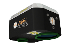
The Riegl VQ-840-G. (Photo: Riegl)
Bathymetry. For the bathymetric segment, the Riegl VQ-840-G has entered the marketplace. Designed for combined topographic and hydrographic surveys for use with large UAVs from lower flight altitudes, the scanner carries out laser range measurements for high-resolution surveying of underwater topography utilizing a green laser beam.
The scanner’s compact, lightweight and robust housing also can include an optional digital camera and an additional, fully integrated infrared laser rangefinder, and is compliant with typical hatches in aircrafts and with stabilized platforms.
The Riegl VQ-880-GII. (Photo: Riegl)
Airborne laser scanning. The Riegl VQ-880-GII is a further improvement of the VQ-880-G topo-hydrographic airborne laser scanning system, offering online waveform processing and full waveform recording.
The improved setup includes a green laser channel, an integrated infrared laser channel, and an integrated dual camera system for RGB and IR. Typical applications include coastline and shallow water mapping, acquiring base data for flood prevention, and measurements for aggradation zones.
Also available are the VQ-780i airborne laser scanner and the VQ-1560i dual wavelength airborne mapping system.
Uplift adds commercially trained pilots and expands PrecisionHawk’s industry expertise and relationships in drone-based services for construction and facility management nationwide.
Uplift specializes in the delivery of turnkey inspection services for construction, building information management and real estate, and has provided drone services for national and global brands.
Its nationwide network of commercially trained drone pilots will join PrecisionHawk’s Droners.io network of more than 15,000 drone pilots. Suzanne El-Moursi, CEO of Uplift, will join PrecisionHawk’s executive leadership team managing the company’s construction line of business.
This is the fifth acquisition for PrecisionHawk in 2018. Early acquisitions include Droners.io and Airvid. In September, it purchased both Hazon Solutions and InspecTools which specialize in the delivery of inspection services and technology for the energy industry. Their integration with PrecisionHawk has created dynamic synergy, providing solutions that elevate airborne intelligence and strengthen the data value chain for the enterprise.
Similar to the energy space, the construction industry has experienced a rapid uptake in the adoption of commercial drone technology. Drones are now one of the leading innovative technologies that are transforming the construction process since they decrease the need for lengthy visual inspections, reduce planning time, improve worker safety and identify problems.
Uplift Data Partners was formed in 2015 as a fully integrated subsidiary of Clayco, one of the nation’s largest architecture, engineering, design-build and construction firms, with more than $2 billion in annual revenue.
Through the acquisition, Clayco will exclusively source its construction projects to PrecisionHawk, and will serve on PrecisionHawk’s Board of Advisors to support the growth of the company’s services and software in the construction industry.
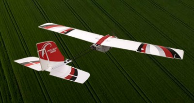
The PrecisionHawk UAV. (Photo: PrecisionHawk)
“PrecisionHawk is leading the commercial drone market by combining superior technology with deep expertise in the markets that they serve,” said Bob Clark, Clayco CEO. “Through this acquisition, Clayco customers gain access to a new level of technological sophistication for more scalable and robust operations, while continuing to benefit from Uplift’s deep understanding of the demanding nature of engineering and construction industry drone missions,.”
“This acquisition displays PrecisionHawk’s commitment to strengthening our technology and expertise in high-growth markets,” said Michael Chasen, PrecisionHawk CEO. “By combining PrecisionHawk’s leading-edge products and services with Uplift’s industry experience and training standards, our customers will receive best-in-class aerial data and analytics for complex construction and facility inspection projects through a simple and easy to procure process.”
“Our mission at Uplift is to support the modernization of the architecture, engineering and construction (AEC) industry by creating tools and training that improve the accessibility of drone services, thereby delivering true value to construction projects,” said Uplift CEO Suzanne El-Moursi. “The construction industry is uniquely rugged, yet defined by innovation and intelligence, and we are thrilled to join PrecisionHawk, a company that is both aligned to this mission and committed to the growth and expansion of the industry.”
A roundup of recent products in the GNSS and inertial positioning industry from the November 2018 issue of GPS World magazine.
OEM
Simulator signals
GPS L5 and Galileo E5 added to simulator
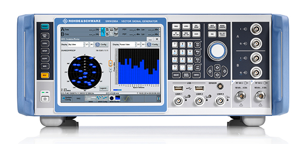
Photo: Rohde & Schwarz
Rohde & Schwarz has added GPS L5 and Galileo E5 simulation capabilities to its R&S SMW200A GNSS simulator. The R&S SMW200A GNSS simulator is designed for efficient test and characterization of multi-constellation and multi-frequency GNSS receivers. It now enables generation of complex and highly realistic test scenarios with up to 144 channels in the GNSS frequency bands L1, L2 and L5. In addition to GPS (L1/L2/L5), GLONASS (L1/L2), Galileo (E1/E5) and BeiDou (L1/L2), the R&S SMW200A also supports signal generation for QZSS and SBAS on L1. Channels can be routed to up to four RF outputs, so that even multi-antenna systems can be tested. The R&S SMW200A can generate complex coexistence and interference scenarios with multiple interferers.
The BlueSky GNSS Firewall enables critical infrastructure providers to harden the security of their operations from GPS threats and deliver a more reliable and secure service. The security-hardened system provides protection against GPS threats such as jamming, spoofing and complete outage. It also supports a range of precision timing technologies, including atomic clocks, to enable continuous operation when GPS may be completely denied for extended periods. The TimePictra software management suite provides centralized control and visibility of GPS reception across regional, national and global geographic areas. It can incorporate an optional internal miniature atomic clock.
For reference deployments, CORS networks and monitoring
The VeraChoke GNSS antenna. (Photo: Tallysman)
The VeraChoke is a high-accuracy choke ring antenna with a choice in form factor for reference and monitoring applications. The VC6100, the first model variant of the VeraChoke, shares a common high-efficiency element design with its counterpart VeraPhase. With the choke-style form-factor, however, the rings have been optimized for all GNSS signals and are slightly pyramidal in shape to improve reception of low-elevation satellites. The VC6100 offers a tight phase center variation (PCV) of no more than ±1 mm for every frequency. It is capable of receiving all GNSS signals, and achieves a very low axial ratio. The antenna also supports large and small SCIGN radomes.
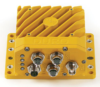
Duro Inertial is a ruggedized version of Swift Navigation’s Piksi Multi dual-frequency real-time kinematic (RTK) GNSS receiver combined with Carnegie Robotics’ SmoothPose sensor fusion algorithm, which fuses GNSS and inertial measurements into a combined solution. The blending of GNSS and inertial measurements provides a dead-reckoning capability that allows Duro Inertial to provide a highly accurate, continuous position solution during brief GNSS outages and to deliver a robust precision navigation solution in harsh GNSS environments.
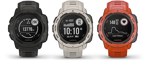
The durable Instinct has GNSS; three-axis compass; barometric altimeter; and wrist-based heart-rate sensor. The watch includes a built-in sports apps, smart connectivity and wellness data. It is built to endure challenging environments, and is constructed to military standards for thermal, shock and water resistance. The multi-GNSS feature helps users track their location in challenging environments, while the Garmin Explore app helps plan and track a trip.
The Navsight Land & Air Solution provides high-performance inertial navigation to make surveyors’ mobile data collection easier, whether for mobile mapping, GIS or road inspection. The solution consists of an inertial measurement unit (IMU), available at two different performance levels, connected to Navsight, a rugged processing unit embedding fusion intelligence and a GNSS receiver. It also has connections for external equipment such as lidar, cameras or computer. SBG’s fusion algorithms allow the company to get the best performance from inertial, odometer and GNSS technologies; exclude false GNSS fixes; and improve the trajectory in complicated areas such as urban canyons, forests and tunnels. The solution supports all GNSS constellations, and real-time kinematic (RTK) and precise point positioning services such as Omnistar and TerraStar.
iSTAR Pulsar is designed to capture 360-degree data while mounted on a vehicle, drone or on foot. An upcoming feature in cloud-based processing software VR.WORLD uses artificial intelligence and image recognition to analyze the images captured by iSTAR Pulsar so that objects like cars, trucks, traffic lights, road signs, pedestrians and cyclists can be automatically identified in images. Handheld 3D mobile mapping company GeoSLAM and mobile mapping software company Orbit GT have introduced integration with iSTAR Pulsar.
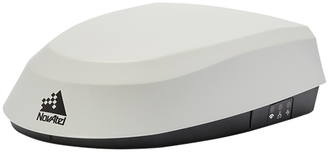
The SMART7 family features NovAtel’s GNSS + inertial navigation system (INS) SPAN technology; future-ready GNSS; Wi-Fi and internet protocol connectivity; superior tracking performance; and TerraStar-C PRO corrections. It is designed to increase GNSS availability, accuracy and reliability for major precision-agriculture equipment manufacturers. The SMART7-S includes SPAN technology, the SMART7-W includes Wi-Fi and an integrated NTRIP client, and the SMART7-I model also incorporates Ethernet. All SMART7 models provide exceptional positioning availability using signals from all constellations and frequencies to deliver assured positioning anywhere.
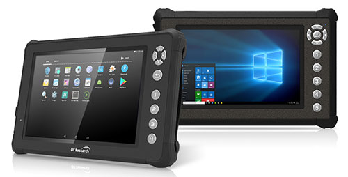
The DT301X rugged military-grade tablet is purpose-built to enhance the precision of 3D surveying, crime and crash scene reconstruction, and bridge and other construction inspections. An option is a dual-frequency GNSS module for real-time mapping and positioning. The tablet integrates the Intel RealSense depth camera, which provides real-time 3D imaging providing accurate measurements for CAD, engineering, design, utility management and crime-scene forensics. A high brightness 10.1-inch touchscreen offers flexible viewing in a wide range of lighting, and an Intel eighth-generation Core i5 or i7 processor offers high-performance while still being energy efficient. With high-capacity 60- or 90-watt hot-swappable batteries, the DT301X keeps working continuously, complemented with a variety of battery chargers so fully charged batteries are always available.
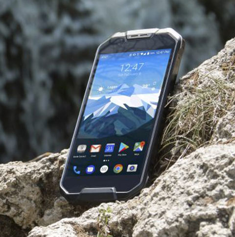
The Cedar CP3 rugged smartphone is capable of data collection and communication. It has a high-visibility 5.5-inch AMOLED display; 14- to 16-hour battery life operating at full brightness and running GPS; 16-megapixel user-facing camera and dual 12-megapixel rear camera; and 6 gigabytes of RAM with 64 gigabytes of internal storage.
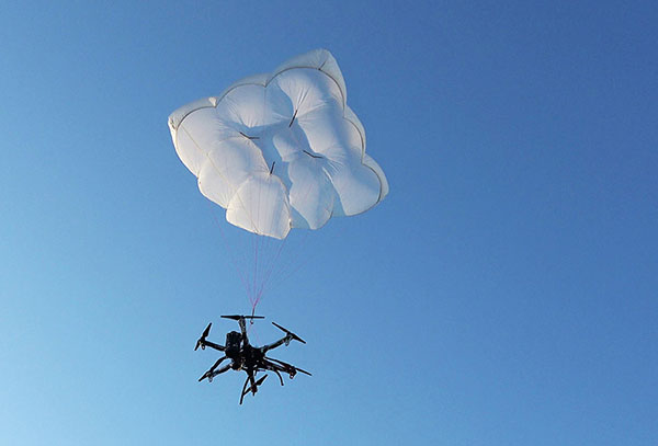
Parachute rescue system DRS-5 is designed for multicopters up to 8 kg; the DRS-10 for multicopters weighing 5–20 kg. The system consists of a carbon cage in which the parachute is stored as well as associated electronics. The electronics, including the sensors, monitor the flight status of a drone independent of the flight controller. A sophisticated algorithm merges this sensor data, enabling automatic crash detection and parachute ejection. All flight data and movements are recorded in a black box.
PrecisionPass assesses UAV data collected in the field. The toolkit lets pilots quickly determine if a data-collection job meets the required criteria or if it needs to be collected again. PrecisionPass assesses coverage, assesses image resolution and quality, reviews required metadata, speeds upload and processing times, and packages data for processing. The immediate feedback reduces the risk of failures during the analysis stage, all but eliminating the need to re-fly a mission, so customer needs are met in a timely and cost-efficient manner.
The Skyfish computing platform fully automates crucial infrastructure inspection and measurement tasks. It supports DJI and PixHawk flight controllers and other drone architectures, as well as 3D modeling software from companies such as Bentley Systems. Its easy-to-use interface enables anyone to fly, inspect and model complex infrastructure. The platform also pre-processes the collected infrastructure data and metadata to help create impeccable 3D models.
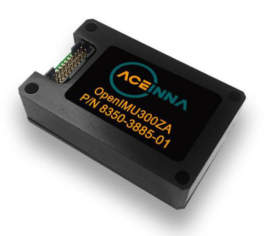
OpenIMU is a professionally supported, open-source GPS/GNSS-aided inertial navigation software stack for low-cost precise navigation applications. Integrating an inertial measurement unit (IMU)-based sensor network improves navigation and self-location capabilities. It is aimed at developing autonomously guided vehicles for industrial applications, autonomous cars, industrial robots and drones. OpenIMU enables advanced localization and navigation algorithm solutions; its extensible software infrastructure provides the code needed for algorithm development. A hardware development kit includes JTAG-pod, precision mount fixture, EVB and an OpenIMU300 module that features Aceinna’s 5 deg/hr, 9-Axis gyro, accelerometer and magnetometer sensor suite with an onboard 180-MHz ARM Coretex floating-point CPU.
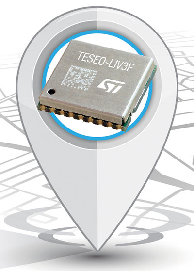
The Teseo-LIV3F module incorporates the Teseo III receiver. It speeds application development and adds up to 16 MB of Flash memory for firmware updating or data logging without a backup battery. Used by automotive and industrial sectors, the Teseo III multi-constellation receiver combines high accuracy with fast response time and low power consumption. The Teseo-LIV3F module enables makers and small engineering teams to leverage the Teseo III advantages in creating new products in the industrial and consumer market segments such as vehicle trackers, drones, anti-theft devices and pet locators, and systems for services such as fleet-management, tolling, vehicle sharing or public transportation.
Audi’s latest e-tron electric car will launch in Europe with a digital rear-view system. Developed by Ficosa, the camera monitoring system is made up of cameras and displays that replace traditional external side mirrors to increase safety and comfort. The vision system is comprised of two cameras, integrated into the sides of the car’s chassis, and two tactile displays inside the doors.
DroneShield has launched DroneNode in response to end-user requirements.
DroneNode is an evolution of the company’s DroneCannon product. It is a portable, compact and inconspicuous counter-drone jamming device that law enforcement can use at large outdoor events without raising public concern.
DroneNode comes in a portable case approximately 50 x 50 centimeters square. It can be set up in seconds and requires very little training to operate, the company said.
It can simultaneously jam 2.4 GHz, 5.8 GHz and GNSS L1 and L2 bands up to one kilometer, causing drones to return to their point of origin or land. DroneNode is also effective against swarm attacks. Emergency broadcasts, cellphone communication and other dedicated channels will not be affected.
According to the company, DroneNode’s covert design makes it a suitable counter-drone solution for public events where protection from drone threats is a priority. Designed within a rugged carry case, DroneNode is easy to transport and is protected from the elements.
DroneNode is powered by a NATO-approved self contained battery with room for a second battery stored in the accessories tray.
“The release of DroneNode continues DroneShield’s leadership in drone security for public events,” said Oleg Vornik, DroneShield’s CEO. “DroneShield’s recent credentials in the area include the 2018 Olympics, the 2018 Commonwealth Games, 2018 ASEAN-Australia Special Summit, the 2017 Hawaii Ironman World Championship, and the 2015 to 2017 Boston Marathons. The company’s products are well positioned to protect large public gatherings globally.”
According to DroneShield, the product is particularly relevant given the recent drone attack on the Venezuelan president and the high-profile mail bomb terrorist attacks in the United States, heightening the awareness of law enforcement globally to potential threats to high-profile political targets.
A Venezuela soldier received head injuries in a the drone attack against the president. (Photo: Released by Xinhua News Agency)
FCC Authorization Pending. DroneNode and DroneCannon have not been authorized as required by the U.S. Federal Communications Commission (FCC). The devices are not, and may not be, offered for sale or lease, or sold or leased, in the United States, other than to the U.S. government and its agencies, until authorization is obtained.
The use of such devices in the United States by other persons or entities, including state or local government agencies, is prohibited by federal law. Laws limiting the availability of such devices of certain types of users may apply in other jurisdictions, and any sales will be conducted only in compliance with the applicable laws.
Kespry and DJI are partnering to offer the DJI Mavic 2 Pro drone as part of the Kespry stockpile measurement solution for mining and aggregates companies.
The solution delivers the Kespry autonomous flight and aerial intelligence experience for stockpile measurement using a DJI drone. It enables large aggregates and mining companies to standardize and capture stockpile data across all their sites in the Kespry platform, while continuing to use Kespry 2s drones to support mine and site planning operations, Kespry said.
Integration of data captured from a DJI drone is the next innovation in the development of the Kespry industrial sensor platform.
Kespry provides inventory management and mine planning data to more than 200 mining and aggregates companies. As these customers scale their use of drone data, they are looking to standardize on a single platform to organize and analyze that data across sites, geographies and product divisions — even when those sites are highly distributed, Kespry said.
The addition of the DJI Mavic 2 Pro to the Kespry lineup is designed to enable even more site data to be centralized in the Kespry cloud. It will be available with a new, cost-effective purchase point designed to support using Kespry across more sites.
“Drone data is now the standard approach for measuring stockpiles at mine sites, however, millions of dollars are wasted through reconciling inconsistent data from different platforms and the time involved getting that data ready for analysis,” said George Mathew, CEO and chairman at Kespry. “Our goal with the addition of the Mavic 2 Pro to our solution is to respond to our customers wishing to use the Kespry aerial intelligence platform across all mine sites to standardize how stockpile data is generated — lowering their costs and helping drive the profitability of every site.”
“DJI is excited to have Kespry offering the Mavic 2 Pro as part of its aerial intelligence platform portfolio,” said Jan Gasparic, director of strategic partnerships, DJI. “Pairing the Mavic 2 Pro with Kespry’s industry leading AI, ML, and analytics capabilities will be of enormous benefit to mining companies that are looking to take advantage of drone technology in a portable and powerful package.”
According to the companies, the integration of DJI’s drone and sensors into the Kespry platform is the latest innovation in the delivery of an industrial sensor network, closely following Kespry’s recently announced high-resolution thermal capabilities for industrial inspection.
This expansion in the range of data that can be explored and analyzed in the Kespry platform further enables customers to protect and maximize their assets across industrial sites.
The Kespry platform is now capable of processing and analyzing a wide range of sensor data, enabling the future creation of industry-specific applications, including those under current development with leaders in the energy sector.
“We have sites in North Carolina, Pennsylvania, Ohio and Maryland, so with the Kespry platform and DJI drone, we’ll be able to fly multiple sites at one time,” said Justin Dermont, accounting manager at Russell Standard. “I could be flying in Erie while my partners fly in North Carolina, but still be able to get the data in real time to the Kespry cloud.”
“Having DJI as part of the Kespry system will help with the flexibility and the timeliness of us being able to take inventory at multiple locations, especially when we have to take inventory at the end of production, or month end, to make sure we have accurate readings,” said Craig Schiebel, controller at Russell Standard. “Being able to take inventory simultaneously at multiple locations is huge.”
“We’re growing our business and recently acquired some new sites,” said Kyla Jungclaus, senior accountant at Brannan Companies. “We need all of our inventory to be done in just a couple days, so introducing the DJI drone to have another pilot surveying at some of our other locations will get inventory done even faster. I know that our measurements will be consistent and accurate even if I don’t do them myself, and I can manage them all in a single account in the Kespry cloud.”
Kespry is offering the Mavic 2 Pro as part of its fully-managed, end-to-end annual subscription model. Kespry customers that choose the Mavic 2 Pro for stockpile measurement will benefit from the full Kespry experience, including its acclaimed support, training, customer success team, and drone up-time guarantee.
The Kespry stockpile measurement solution with DJI will be available Q1 2019.