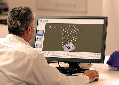
MAGNET Inspect is designed for UAV data collection. (Photo: Topcon)
Topcon Positioning Group has introduced software to facilitate the data-processing workflow for UAV (unmanned aerial vehicle) infrastructure inspection.
MAGNET Inspect efficiently manages large UAV data sets to create inspection reports. It is designed to allow operators to easily visually navigate UAV photos, aligning 3D reality meshes with raw georeferenced images in one location and filtering them based on selected criteria including field of view.
“MAGNET Inspect will work with models from virtually any UAV,” said David Ahl, director of software product management. “When combined with Intel Falcon 8+ Drone – Topcon Edition and Topcon ContextCapture, powered by Bentley Systems, the software enables operators to efficiently navigate, annotate and create reports with inspection photos, effectively creating a very strong end-to-end inspection workflow.
MAGNET Inspect is now a key element of the Topcon end-to-end UAV and data processing workflow for inspection projects, Ahl said. It’s use aims to increase safety and speed data collection compared to traditional methods.
“The software allows operators to easily document the observations and report them. Images from the inspection can be flagged to indicate whether there are structural issues and annotated with built-in free-hand graphical tools. Data reports can then be created to include a preview image and link to high resolution annotated image,” Ahl said.
The ThunderBuild program. (Photo: Topcon/ThunderBuild)
Acquisition of ThunderBuild. In another announcement, Topcon announced the acquisition of ThunderBuild BV Group, expanding the portfolio of Topcon paving solutions. Based in Eindhoven, the Netherlands, ThunderBuild develops software related to logistics management with a primary focus in the asphalt market, as well as additional applications that pertain to the transport of bulk materials.
A number of geospatial companies played a key role in the government’s response to the Kilauea Volcano eruption. The volcano on the Big Island of Hawaii began erupting May 3, and while quiet for more than a week, it could resume erupting at any time.
Mapping the flow. As a resident of Hawaii, Brennan O’Neill, Hawaiian branch manager of Frontier Precision, was in a unique position to offer support. Frontier Precision provided free access to technology and expertise to assist in mapping the lava flow.
“I had to help out,” O’Neill said. “It was tearing at my soul. For a geologist, it’s even more powerful than that. The lava flow is like a living mass that has a mind of its own, creeping, glowing — an upside-down conveyor belt surging forward and burning everything in its path.”
Through Frontier Precision, O’Neill offered high-tech mapping equipment, his own expertise, and the help of Nathan Stephenson, an applied geospatial engineer working in the company’s Denver office.
“We used a combination of Trimble R10s and Trimble R8s to gather accurate data points on the ground,” Stephenson said.
This thermal map shows the fissure system and lava flows as of 6 a.m. on Saturday, Aug. 11. The thermal map was constructed by stitching many overlapping oblique thermal images collected by a handheld thermal camera during a helicopter overflight of the flow field. The base is a copyrighted color satellite image (used with permission) provided by Digital Globe. (Map: USGS)
The mapping team flew UAS drones over the flow to gather visual imagery data, matched it to the ground reference points, stitched the photos together and draped it over county maps. The process was repeated as often as needed — daily, and sometimes even hourly — to show the speed and direction of the flow.
Stephenson isn’t new to mapping lava flows. As a graduate student at the University of Hawaii – Hilo, he worked on collecting data on the Pahoa eruption in 2014, and he’s seen advances in technology in just a few years.
“One thing we have now that we didn’t have in 2014 was a thermal radiometric camera that helps us map more accurately at night and enables us to capture large heat signatures.”
The collected data helps Hawaii Civil Defense and other agencies keep the public informed and safe, and in the long term it also contributes to the store of scientific knowledge about eruptions and lava flow behavior.
Lidar image of the Hawaii dataset showing the Kilauea Calderand the Halena’uma’u Crater and within it. (Image: Quantum Spatial)
Airborne lidar insights. Another technology that aids in volcano response is lidar. High-resolution lidar surveys help first responders, scientists and government agencies monitor Kilauea conditions and predict future lava flows.
Independent geospatial data firm Quantum Spatial Inc. (QSI) has conducted high-resolution lidar surveys of areas surrounding the Kilauea volcano eruption in Hawaii.
The emergency response effort was part of the U.S. Geological Survey’s (USGS) Rapid Response Imagery Products (RRIP) in support of the Kilauea’s 2018 East Rift Zone – Remote Sensing Acquisition Requirement.
The USGS Hawaiian Volcano Observatory (HVO), along with emergency responders, government agencies and academics, will use the data to better understand the conditions and characteristics of the volcano, and help planners model potential lava flows, which may better predict and respond to future flows and enhance safety of residents.
The QSI team, which included GEO1 and Windward Aviation, deployed within days to acquire high-resolution lidar at point densities averaging from 40 to 80 ppsm, with up to 150 ppsm in select areas and 100-mp digital imagery using a Riegl dual VUX-1 LR sensor pod equipped with ABGPS/IMU mounted on a Hughes 500D helicopter.
The project required 11 missions over the course of six days, operating at times as low as 500 feet above the ground and above active flows and nearby erupting calderas. With a need for a quick turn around, QSI deployed an analyst with the flight crew to post process each mission within hours of collection.
The data was uploaded to the Geospatial Repository and Data Management System (GRiD) interface, developed by the U.S. Army Corps of Engineers (USACE), where additional data products have been developed and provided to the response team that includes FEMA, Hawaii’s Emergency Operations Center (EOC) and the Hawaii County Civil Defense.
After data collection, QSI measured topographic shifts during the processing by comparing new data with a 2011 lidar collection from the same area. Survey specialists and USGS experts confirmed within hours of processing QSI’s lidar data that areas within the site had shifted up to 1.5 meters east, 2 meters to the north and 1 meter in elevation.
USGS scientists will continue to examine the new topographic data to better understand the nature of these shifts, and integrate it into lava flow models for more accurate predictive modeling.
The eruption in action. Using small unmanned aerial systems (sUAS) together with air-quality sensors, advanced imaging tools and Esri’s spatial analytics and mapping, a team from the Center for Robot-Assisted Search and Rescue (CRASAR) provided real-time aerial views of the eruption.
The five volunteers armed with drones, advanced sensor systems and GIS technologies joined the response effort May 14-19 at Kilauea Volcano Lower East Rift Zone to assist in tracking and predicting the ongoing volcanic eruption. The team supplemented the University of Hawaii Hilo’s (UHH) sUAS capabilities, allowing UHH sUAS operators to focus on geographical and volcanology.
The CRASAR team identified a new fissure not visible from the ground, projected the lava flow rate during the night when manned helicopters were not allowed to fly, and provided ongoing data collection from new thermal sensors technology.
During the six-day Leilani deployment, the CRASAR team flew 44 sUAS flights, including 16 at night, using DJI 200, 210, Inspire, and Mavic Pro drones. Esri’s Drone2Map for ArcGIS together with Hangar’s Enterprise Platform for 360-degree imaging enabled rapid 360-imaging for situational awareness.
DJI’s new XT2 thermal sensor provided unprecedented drone-based air-quality monitoring. Video and data were shared with local first responders using FirstNet, the first high-speed, nationwide wireless broadband network dedicated to public safety.
The CRASAR response marks the first known use of sUAS for emergency response to a volcanic eruption and first known use of sUAS for sampling air quality.
The GIS mapping and imaging technologies responders used on the scene at Kilauea Volcano Lower East Rift Zone are available here.
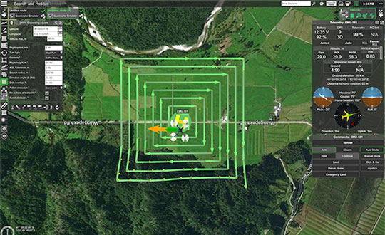
UgCS, a provider of mission planning software for unmanned aircraft systems (UAS), and public safety and disaster response UAS expert Airborne Response have developed a comprehensive search capability for drones that will allow remote pilots to more effectively conduct search-and-rescue operations using the UgCS platform.
The software enhancements will provide users with customizable search patterns such as the “expanding square” and “creeping line” that can be easily deployed in emergency and non-emergency situations.
Based on the flight altitude input by the operator, the UgCS software will automatically calculate key variables such as the course heading and track spacing necessary to provide the prescribed coverage area for a search target.
Tom “Oaty” Oatmeyer is an air rescue expert with 28 years of experience piloting helicopters for both the U.S. Air Force and the Miami-Dade Fire Rescue department. As an aircraft commander, Oatmeyer is credited with saving more than 150 lives during emergency and disaster response operations.
Oatmeyer worked directly with the UgCS development team to bring the new features to fruition.
“As first responders, we are trained to develop an emergency search plan using time-tested and proven tactics,” said Oatmeyer, chief pilot, Airborne Response. “The new enhancements to the UgCS mission planning software will allow remote pilots at every skill level to quickly plan and implement a professional search mission with a UAS.”
Airborne Response and UgCS will be hosting a joint web conference on Thursday, Aug. 16, at 2 p.m. ET to officially unveil the new search features of the UgCS mission planning software. Register here.
Also, Airborne Response and UgCS have reached an agreement for Airborne Response to offer the UgCS mission planning software and associated training to public safety and emergency response professionals throughout the U.S.
“When lives are on the line, every second counts,” Oatmeyer said. “UgCS now represents another valuable link in the UAS technology chain to enhance the public safety mission.”
“The new UgCS search feature is designed to make searching for a target with a drone as simple and reliable as possible,” said Janis Kuze, sales director at SPH Engineering. “We look forward to continue working with the Airborne Response team to further enhance the software capabilities and implement additional search pattern features.”
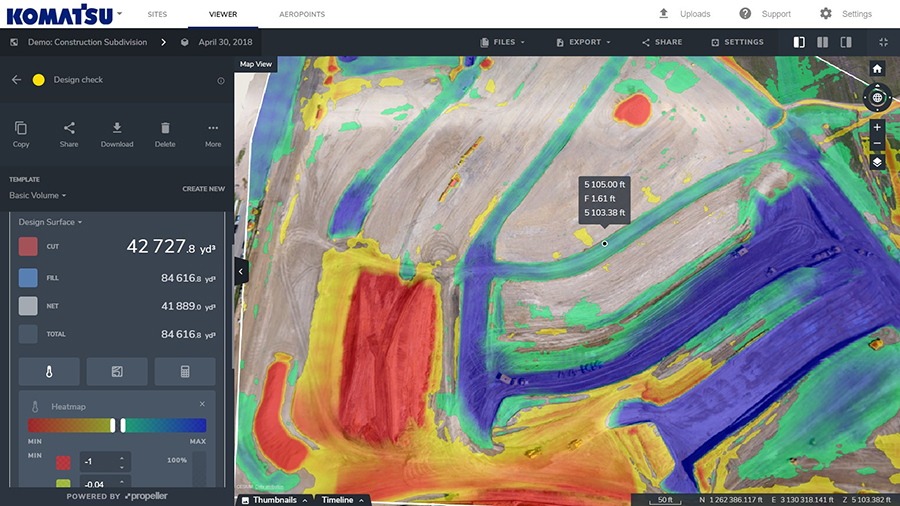
Komatsu America Corp. and Propeller Aero Inc. are partnering to boost the efficiency of construction job sites using drone-powered mapping and analytics software.
With drones becoming an increasingly common worksite tool, Komatsu has identified aerial mapping and analytics as a key component of its Smart Construction initiative — a range of integrated hardware and software products designed to offer an end-to-end workflow for each phase of construction.
Komatsu America Corp. spent several years testing various commercial drone mapping and analytics products in North America. In Propeller, Komatsu found a robust product suited to meet the needs of modern construction operations. Propeller expertly balances ease-of-use with survey accuracy and reliability, Komatsu said.
Propeller’s processing machinery crunches thousands of drone images in hours, and delivers the results as a cloud-based 3D model to the user’s desktop or tablet. From there, powerful collaboration and analysis tools let users perform height, volume and slope calculations, and measure change over time to confirm that a project is on track, the companies said.
(Image: PRNewsfoto/Propeller Aero)
Propeller’s technology platform supports multiple coordinate systems, including local site calibrations. This allows personnel to capture up-to-date survey data expressed in the specific geospatial coordinates they already use on that job site. Local grid support is crucial for ensuring drone-captured maps and models match up with plans and previous surveys.
“A Komatsu Smart Construction jobsite by definition is technology enhanced and production optimized,” said Jason Anetsberger, senior product manager at Komatsu America Corp. “Adding Propeller Aero as one of our key partners gives our North American distributors and customers exceptional capabilities to achieve this standard in the aerial mapping space. Propeller combines simple, yet powerful analysis tools with accurate and fast site visualization.”
“Worksites are starting to see the real business value of accurate, up-to-date drone data,” said John Frost, vice president of business development at Propeller. “We drive that value through workflows that enable everyone to understand who’s moved what material, how much, and where. It’s all about empowering worksites with the information they need to make data-driven decisions to reduce costs, ensure quality, and use resources efficiently. Now more than ever, stakeholders on site, or in the head office miles away, can stay up-to-date with exactly what’s happening on the ground.”
“Anyone can fly a drone — it’s what you do with the data that makes an impression,” said Chris Faulhaber, smart construction business manager at Komatsu Equipment Co. “Propeller provides fast, accurate data processing via a web platform that is unparalleled. The platform is easy to use, facilitates healthy collaboration and delivers vital information quickly — so everyone can work together better and faster than anticipated.”
NDCOE’s mission is to save lives and reduce air hazards from drone incursions by empowering a shared safety vision with the the U.S. Federal Aviation Administration’s (FAA’s) integration of drones into the commercial air traffic system.
Located in Las Vegas, with facilities donated by technology infrastructure company Switch, NDCOE will provide safety incursion research data, drone technology best practices and educational materials.
The new center will conduct public workshops that promote and protect the public’s safety and privacy in an open and ethical manner.
Over the last decade, UAS, more commonly referred to as drones, have experienced an unprecedented boom within aviation. Coinciding with the increase in popularity, incidents involving drones in tourist areas, as well as risks to larger manned aircraft are on the rise and present high-liability risks to property owners.
Safe and successful UAS operations rely on quality training, end user education and maximizing public safety processes. To protect and educate residents and visitors, the center seeks to protect against drone users who pose a public safety hazard due to inexperience or malicious drone operations. Such hazards include drones hitting people or that have the potential to cause an airline disaster, and drone operations that violate safety, privacy or drone laws near high-traffic public places, at airports, near military bases or near critical infrastructure.
NDCOE will also advance drone surveillance, detect and avoid (remote sensing), wildland firefighting, gas-leak detection, and time-sensitive medical delivery technologies for life-saving medical equipment and organs.
“In addition to fostering major advances in UAS technology with testing partners like the FAA, NASA and Switch, Nevada is also home to the most registered drone users in the nation in Las Vegas,” said Paul Anderson, executive director of the Nevada Governor’s Office of Economic Development. “This dynamic makes such a program as the Nevada Drone Center of Excellence for Public Safety a natural step as drones increasingly become a bigger part of our daily lives.”
In a recent state-wide Nevada Drone Industry survey by the University of Nevada, Las Vegas (UNLV) and NIAS, the NDCOE received support to open the first center of its kind in the U.S. In the survey, almost 80% of respondents were concerned about a recreational drone hitting an airline and causing an airline disaster, and almost 90% were concerned about aerial drones illegally penetrating FAA airspace without authorization at outdoor events such as sports stadium, concert or at large events.
“We are taking an aggressive approach toward solving the complex UAS Industry challenge of mitigating drone incursions into the National Airspace System — one of the toughest FAA challenges today,” said Chris Walach, senior director, NIAS and the FAA-designated Nevada UAS Test Site. “What we are doing in Nevada will be of immense value to the DOT, FAA, DHS, DOJ, commercial airlines, visitor venues, and the UAS Industry. This new center will help advance infrastructure protections, drone detection innovations, enhance air safety, and expand air commerce in Nevada.”
NIAS and the FAA-designated Nevada Unmanned Aviation Test Site lead the growth of the Nevada UAS industry through business teaming relationships, collaborating with primary research institutions on UAS research and development, and enhancing the Nevada UAS Industry knowledge base to attract new and permanent business and create jobs in the State of Nevada.
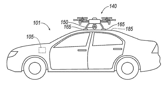
Ford has applied for a patent that would send a drone to dock with an autonomous vehicle and act as a surrogate sensor if one of the car’s sensors failed. The UAV then uses its own sensors to guide the car to a repair facility.
A UAV docks with a car. (Diagram: Ford’s patent application)
The filing from Ford Global Technologies, a subsidiary that manages and commercializes patents and copyrights, outlines the process.
Once the vehicle registers a fault in one of its sensors, it uses a vehicle-to-vehicle (V2V) network to summon the drone, which flies to the vehicle, receives authorization, and then lands atop it. The UAV then serves as a replacement sensor while directing the vehicle to a nearby repair center to fix the car’s sensor.
Ford developed the technology to aid autonomous vehicles that have lost a critical navigation sensor; autonomous cars use GNSS, short- and long-range radar, lidar, cameras and ultrasound.
After a couple of good hours of progress, we suddenly ran up against a massive “tail-back” — as the English call road-blocks — on the A303. We eventually crawled along further and discovered that all the rubber-neckers were slowing to grab a glimpse of Stonehenge, which you can see on the left, not far from the road. A little further on I saw a sign for Farnborough and thought that its surely around this time of year for that huge aerospace show known as the Farnborough International Airshow. So when I arrived home after almost three email-less weeks, it was not surprising that my inbox was crammed with lots of European aerospace news.
SkyGuardian MQ-9B
General Atomics (GA-ASI) seems to have come out tops in UAV public relations, flying its MQ-9B company-owned SkyGuardian from Grand Forks, North Dakota, to Royal Air Force (RAF) Fairford in Gloucestershire, U.K. on July 10-11 — that’s a 3,760 nautical mile flight in a fraction just over 24 hours. The RAF has operated the MQ-9 Reaper for over 10 years and the RAF configuration of the MQ-9B will apparently be called PROTECTOR RG Mk1. It just so happens that the RAF is celebrating its 100-year anniversary, so GA-ASI took the opportunity to drop in and say hello at a much smaller airshow at Fairford July 13-15.
Then they announced last week at Farnborough that GA-ASI had been selected to provide UAS to the Royal Netherlands Air Force (RNLAF) following consideration by the Ministry of Defence for the Netherlands. Doesn’t sound exactly like a contract yet, but its close enough to say that the Netherlands will take delivery of the Predator B/MQ-9 Reaper Medium Altitude, Long-endurance UAS. They also reminded us that the Spanish Air Force is to take delivery of MQ-9 systems in 2019.
From a SatNav point of view, we might also be interested that the GPS receiver on this UAV has also been upgraded to add Galileo signal capability — a requirement for what seems to be an expanding number of government forces in Europe. No luck yet in securing better information from GA-ASI about this upgrade, but Farnborough has likely kept them hopping, so hopefully more news later.
Zephyr S High Altitude Pseudo-Satellite UAV
Photo: Airbus
Fresh on the heels of taking on the Canadian Bombardier C-Series program (now the Airbus A-220) and closing the first deal with JetBlue for 60 of these aircraft, Airbus has committed to production of the Zephyr S HAPS (High Altitude Pseudo-Satellite) solar–electric, stratospheric UAV.
Zephyr has an 82-ft. wingspan and is designed to operate on solar power in the stratosphere at an altitude of around 13 miles emulating equivalent services provided by satellite. This is well above clouds, the jet stream and the ozone layer, and importantly well away above regular air traffic. Airbus anticipates the drone flying for up to 100 days without landing (its currently record is 14 days) and to travel up to 1,000 nautical miles per day. It weighs 165 pounds, but can support a payload up to five times its own weight.
The Zephyr aircraft began its maiden flight in Arizona a few days ago — the “qualification flight” is being supported by both the U.K. and U.S. governments — and the U.K. Ministry of Defence is the launch customer for Zephyr. The aircraft has so far logged around 1,000 hours total flight time. The test flight will conclude once engineering objectives have been met. Other solar-cell powered aircraft have struggled with landing or take off due to the large wing, light weight and hence stability under wind gusts, so several projects have not progressed past the R&D stage. Airbus & RAF’s commitment to production indicates their faith in the aircraft design.
Staying with the U.K. theme, the Goodwood Estate in Chichester, England — famous for the Goodwood car racing circuit — has recently hosted the Goodwood Festival of Speed, which apparently included drone racing. And at the same time, a Guinness World Record drone speed record was established.
Wingcopter XBR
The Wingcopter XBR is a tilt-rotor UAV with two lift props and two horizontal velocity props, and the drone flown by teenage drone racer Luke Bannister reached an average of 240.6kmph (~150m/h) over a Goodwood 100 meter track, flying over the measured track in both directions to account for wind. This set the world record for the fastest ground speed by a “remote-controlled tilt-rotor aircraft.” A previous record of 179.6 mph has been achieved by a quadcopter drone rather than a tilt-rotor UAV like the Wingcopter, but there is apparently more drag with type of drone, so its classified as a different category of UAV.
Northrop Grumman Triton High Altitude UAV
Northrop Grumman Triton High Altitude UAV. (Photo: Northrop Grumman)
Meanwhile, Northrop Grumman released a statement at Farnborough on their continuing discussions with Germany towards the sale of its high-altitude Triton MQ-4C unmanned surveillance drone, but apparently a lot of work still remains. In April the U.S. State Dept. authorized the sale of up to four drones worth up to $2.5 billion, and the German government has since been working closely with the US Navy towards a deal.
People may recall the previous cancellation of the “Eurohawk” program back in 2013 — under which Germany had planned to buy a version of Northrop’s Global Hawk drone — after escalating estimated costs for civil certification of the vehicle hit 600 million euros ($702 million) — not a minor task in any way.Subsequently, Northrop and Airbus Defense and Space have teamed up on a new ‘Pegasus’ program, which will add UAVs to Germany’s surveillance capabilities — drones flying autonomously as high as 60,000 feet to gather a wide array of intelligence data.
The German government plans to buy three of the drones, equipped with sensors and a mission system now to be engineered by Airbus. Preparations for certifying equipment to enable the drones to operate in civil airspace are moving more smoothly this time, but with deliveries to only start in 2025. Northrop developed the Triton, a marine-based variant of the Global Hawk, under a U.S. Navy contract awarded in 2008. And Australia last month said it plans to buy six Triton aircraft for maritime patrol, initially expected to cost A$1.4 billion ($1 billion U.S.).
So, lots of military drone stuff this month — not unusual given the nature of the Farnborough U.K. airshow, even though Boeing and Airbus also use the show to one-up each other’s announcements of commercial aircraft contracts and options. Lots of good news for General Atomics, not so much yet for Northrop Grumman, and some light relief with high speed drone records at Goodwood. Back to more North American UAV news hopefully next month.
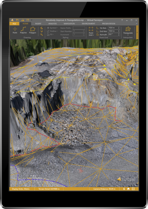
The newly released version 6 of the Virtual Surveyor drone surveying software offers a faster, more efficient workflow and better overall user experience in a more stable platform, according to the software maker.
Version 6 offers new capabilities, an improved licensing system and an extended free application.
“Surveyors who have used the Virtual Surveyor package in the past will be amazed at how easily they can manipulate data and how quickly the software renders results of even the most complex topographies,” said Tom Op ‘t Eyndt, managing director of Virtual Surveyor nv in Belgium.
Virtual Surveyor leverages the expertise and interpretation skill of a land surveyor and combines it with the computing power of the computer, the company said.The software generates an interactive onscreen environment through orthophotos and digital surface models, generated from the unmanned aerial vehicle (UAV), where the surveyor selects survey points and breaklines to define the topography.
Image: Virtual Surveyor
Virtual Surveyor enables land surveyors to complement traditional fieldwork with UAV imagery to generate highly accurate topographic products up to five times faster than otherwise possible. It bridges the gap between UAV photogrammetric processing software and engineering computer-aided design (CAD) packages.
“The focus of Version 6 development has been to streamline the workflow — from the importing of drone data to exporting topo information into CAD — to make the surveyor more productive,” Op ‘t Eyndt said.
Key enhancements in Virtual Surveyor 6 include the following:
Easier editing – The new editing functions allows users to quickly select, delete or move individual point and lines placed by the computer during the automated creation of elevation points. The associated Undo/Redo function allows reversing all edit operations.
Better CAD integration – The addition of Descriptor functionality means that point descriptions remain with the point during export to CAD, working the same way as the land surveyor collects data in the field.
3D geometry retained – All points, lines and other data imported into the software, either from a UAV or field surveyed data, retain elevation values and integrate seamlessly into the merged scene. This allows a surveyor, for example, to collect point values from a ditch bottom that may be obscured by vegetation in the drone image and have the bottom points accurately represented in the topography.
Improved drawing tools – Users can now densify (drape) lines and boundaries to map current surface conditions. Individual vertices are now adjustable in all directions and exact X, Y and Z locations can be specified as well. Sub-surface modeling is now possible with these new improvements. Created features can then be exported to CAD for profile or alignment creation.
Extended free plan – Referred to as the Valley version, the free Virtual Surveyor suite has added functionality, including the ability to import photogrammetric data.
Improved licensing – We better honor our principle: “The license follows the user”. With an improved licensing system based on a Virtual Surveyor Identity (email) the user will be able to work where he or she wants.
“The enhanced user experience will continue to appeal to professional land surveyors, who are our core client base,” said Op ‘t Eyndt. “And the seamless integration with CAD and advanced drawing tools will make Virtual Surveyor more attractive to design engineers.”
Virtual Surveyor is available in a free 14-day trial.
A team of five volunteers armed with drones, advanced sensor systems and GIS technologies joined the response effort at Kilauea Volcano Lower East Rift Zone to assist in tracking and predicting the ongoing volcanic eruption.
Using small unmanned aerial systems (sUAS) together with air-quality sensors, advanced imaging tools and Esri’s spatial analytics and mapping, the team from the Center for Robot-Assisted Search and Rescue (CRASAR) provided real-time aerial views of the eruption.
The CRASAR team identified a new fissure not visible from the ground, projected the lava flow rate during the night when manned helicopters were not allowed to fly, and provided ongoing data collection from new thermal sensors technology.
The CRASAR response marks the first known use of sUAS for emergency response to a volcanic eruption and first known use of sUAS for sampling air quality. The CRASAR team provided Hilo Fire Department and the Civil Defense with live streaming of video from the sUAS over the new FirstNet cellular network.
“This latest CRASAR mission is another example of dedicated volunteers working together with private sector partners to deploy technology to save lives and property when disaster strikes,” said CRASAR Director and disaster robotics expert Robin Murphy. “With support from technology partners like Esri, Hangar Technologies, RemoteGeo and RMUS, we are able to both respond to active disasters but also demonstrate to the first responder community best practices and benefits of engaging robots and other technologies in disaster response.”
CRASAR supported tactical response operations at the Leilani, Hawaii, eruption event May 14-19, supplementing the University of Hawaii Hilo’s (UHH) sUAS capabilities and allowing UHH sUAS operators to focus on geographical and volcanology.
During the six-day Leilani deployment, the CRASAR team flew 44 sUAS flights, including 16 at night, using DJI 200, 210, Inspire, and Mavic Pro drones.
Esri’s Drone2Map for ArcGIS together with Hangar’s Enterprise Platform for 360-degree imaging enabled rapid 360-imaging for situational awareness.
Video and data were shared with local first responders using FirstNet, the first high-speed, nationwide wireless broadband network dedicated to public safety.
The CRASAR response team included sUAS pilots Justin Adams of Constellation Consulting Group, David Merrick and Laura Hart of Florida State University Center for Disaster Risk Policy, Jon McBride of Rocky Mountain Unmanned Systems, and Robin Murphy of Texas A&M University. Funding was provided in part through research grants from an insurance partner and the National Science Foundation.
“This eruption is especially impactful because of its location,” said Esri’s Public Safety Lead, Ryan Lanclos. “That makes the CRASAR’s use of drones and mapping technologies, and the near real-time situational awareness it provides of people, homes, businesses and infrastructure during this disaster, a resource first responders will be able to turn to time and again.”
CRASAR’s deployment to Hawaii marked a number of firsts for technology applied to disaster response. To interact with the same GIS mapping and imaging technologies responders used on the scene at Kilauea Volcano Lower East Rift Zone, visit this page.
An upcoming episode of “Advancements” with Ted Danson will explore recent developments in autonomous vehicles such as drones, cars, trucks, excavators and other heavy machinery.
The episode is scheduled to broadcast in the fourth quarter of this year.
Image: Advancements
The segment will focus on Septentrio’s secure GNSS technology for unmanned systems. Septentrio is a designer and manufacturer of GNSS receivers and surveying equipment, delivering accurate and precise GNSS positioning scalable to centimeter-level even in challenging environments.
Advancements will educate viewers about Septentrio’s GNSS technology, which provides both the accuracy and robustness required, while integrating and synchronizing seamlessly with navigation systems and payloads.
“In a few years, autonomous cars will be driving us around, with greater safety, efficiency and comfort than ever before,” said Jan Van Hees, director of marketing and business development, Septentrio. “All of these vehicles depend critically on a multitude of sensors to determine where they are, with robust GNSS sensors at the heart of the system. It is critically important that the GNSS technology used supplies not just highly accurate data, but also a high level of reliability. That’s where the technology from Septentrio comes in.”
Autonomous trucks and agricultural machines are already being used to make worker activities safer and more efficient. Drones can go to places that would otherwise be too expensive or dangerous for human workers to reach.
Farmers use unmanned systems to survey and even spray crops; NGOs employ them to launch search and rescue operations in disaster zones; event coordinators monitor crowds with them at major musical festivals, and conservationists can track and protect endangered species better in risky areas with them.
“For many years now, driven by our customers, we have been developing GNSS technology for industrial applications that is not only very accurate, but also reliable in the harshest of environments,” Van Hees said. “With the advent of drones and the interest in developing autonomous cars and trucks, this focus on secure GNSS is becoming ever more important. It’s exciting to see this technology affecting our daily lives more and more.”
“UAVs and other autonomous systems have an enormous potential in aerial surveying, inspection, and a host of other industries,” said Rochelle Hyman, senior producer for the Advancements series. “The autonomous industry is important to Septentrio, and we look forward to sharing the innovative technologies that have been designed and developed by the company.”
The Advancements series is an information-based educational show, targeting recent advances across a number of industries and economies. Featuring state-of-the-art solutions and important issues facing today’s consumers and business professionals, Advancements focuses on cutting-edge developments, and brings this information to the public with the vision to enlighten about how technology and innovation continue to transform our world.
Commercial drone operators in California and Hawaii — as well as a few areas in Nevada, Utah and Arizona — now can get quickly authorized to fly in controlled airspace, Skyward announced.
Screenshot: Skyward
Skyward is an FAA-approved airspace vendor. With Skyward, pilots can access the FAA’s LAANC (Low Altitude Airspace Notification Capability) across the five states.
This means that pilots with a Part 107 license can get permission to fly in regulated airspace in seconds compared to manual authorizations that can take months, making it significantly easier for businesses of all sizes, particularly in the construction and warehousing industries, to manage a fleet of drones to access valuable, cost-saving data.
The LAANC platform lets UAV operators take advantage of this digital timesaver. Skyward was the first provider approved by the FAA to offer LAANC, and Skyward saw quick adoption by its customers as soon as the prototype was released on Oct. 23, 2017.
This phase of Skyward’s LAANC expansion includes airspace in some of the country’s busiest metro areas, including Los Angeles, the Bay Area, San Diego, Las Vegas and more than 50 smaller air markets. It will help the full diversity of businesses in the west find new ways to use drones in their operations through LAANC capability.
If you’ve registered a commercial drone, the U.S. Federal Aviation Administration (FAA) wants to hear from you.
On June 19, the FAA sent a questionnaire to everyone who has registered a commercial drone – more formally, an unmanned aircraft system (UAS) — for anything but recreational or hobby use.
Most of these owners fly their drones for commercial purposes, but the survey population also includes government departments and other users.
Hobbyists are not included in this survey.
The goal is to collect information on drone flight activities under the FAA’s small drone rule (Part 107), data that will help the FAA improve the services it delivers to the UAS community. Responses to the questionnaire are voluntary and entered 100 percent electronically.
The survey will take about 10 minutes to complete.
The questions include areas such as number of drones registered, number and types of missions completed in 2017, primary locations where the operator flies and types of waivers requested. The survey also asks how operators want to get information about drone-related issues from the FAA, and how satisfied they are with the news channels they use now
The questionnaire is completely anonymous, so responses cannot be attributed to an individual.
If the questionnaire is still sitting on your computer or mobile device, the FAA wants — and needs — your input.