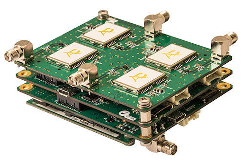
A European Union-funded initiative has developed a low-cost positioning and navigation system for unmanned aerial systems (UAS).
Photo: European GNSS Agency
Using multiple antennas, the device is based on off-the-shelf components and advanced data-fusion algorithms. It fuses GNSS and inertial data to enable accurate and reliable navigation.
The EU-funded Horizon 2020 GLAD-2 project developed the system. The work involved in-depth analysis of algorithms, hardware and software redesign, exhaustive refinement and repeated in-field testing.
Researchers used low-cost GNSS receivers, together with advanced data fusion with an inertial measurement unit, and barometer data to enhance the attitude and position of UAS in harsh GNSS environments. The system also avoided the use of magnetometers, making it immune to magnetic fields, and removing the need for system calibration when the magnetic environment is modified.
Photo: European GNSS Agency
Engineers selected different GNSS antennas and measured their performance according to technical and economic criteria. A multi-antenna approach enabled UAS to take accurate headings without suffering the usual problems inherent to magnetometers.
“The inertial sensors provide an excellent dynamic response at very high data rates, while GNSS serves as an absolute reference to prevent drift. In addition, differential GNSS carrier phase measurements can be used to obtain great accuracy in orientation by using the multi-antenna configuration,” said project coordinator Esther López of Spanish technology company ACORDE.
GLAD-2 achieved the commercialization of the low-cost navigation system, culminating in the European Conformity (CE) certification mark following the corresponding certification process. The CE mark indicates conformity with health, safety and environmental protection standards for products sold within the European Economic area.
The result is a highly competitive product aimed at the low-cost sector of the navigation systems market. “Due to its flexibility, the system fulfils the needs of a wide range of users, not only in UAS, but also in terrestrial and maritime environments applications,” López said.
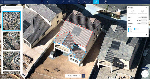
Nearmap high-resolution aerial image showcasing new toolset in MapBrowser, captured Sept. 15, 2018. (Image: Nearmap)
Nearmap has introduced a complete measurement toolset in MapBrowser for the solar, roofing and other rooftop industries.
The new tools allow users to measure roof-pitch, height, width and area, enabling roofers and solar installers to confidently measure rooftops and structures from high-resolution oblique aerial images, the company said.
The new MapBrowser helps customers significantly reduce onsite visits during the quoting and planning stages of projects and complements their remote roof/site inspection workflows, giving many small businesses the power of expensive systems that only large companies use.
“Gone are the days of climbing on roofs to take measurements,” said Tony Agresta, executive vice president of product at Nearmap. “Delivered to the cloud within days of capture, our aerial imagery allows roofers, solar companies and other small businesses to carry out assessments from the comfort of their office. Once the domain of large companies, the new features provide businesses of all shapes and sizes with the tools they need to save time, plan and estimate more accurately at a fraction of the price.”
Using Nearmap’s new tools, roofers and solar companies will be able to:
Prospect more efficiently by viewing and expanding opportunities through aerial maps instead of other, more traditional ways.
Process leads more quickly by qualifying prospects prior to visiting a potential job.
Reduce costs associated with the qualification and proposal stages.
Create better proposals using up-to-date, high-resolution photos, giving companies a better chance at winning a client’s business.
Close more sales with the most accurate and competitive quotes.
Increase revenue without adding systems or headcount.
Businesses in construction, home building, painting, insurance and other industries can also benefit from these new tools to accurately measure areas on properties in three dimensions. Nearmap’s aerial imagery can help users to show context for work being done, and the imagery can be annotated with notes, drawings and measurements that provide details of the plan.
Nearmap Oblique imagery can be accessed through a standard web browser using Nearmap’s intuitive MapBrowser application. In addition, Nearmap Oblique photos are published at sub-7.5cm ground sampling distance (GSD) — better than satellite imagery — which allows users to see great detail, Nearmap said.
The UAV inspection industry continues to grow, as evidenced by these photos of actual end-user application. Unmanned systems follow precise flight paths to gather the data needed for inspection missions in the fields of insurance (home roof inspection), mining, construction and the pulp paper industry.
A free webinar on Thursday, Oct. 25 will show more of these applications and cover the requirements and challenges for positioning technology in commercial applications in urban and remote areas, including those generated by concerns about interference and spoofing.
Latest trends and challenges for drone-based aerial intelligence platforms for insurance and roofing applications
GNSS technology requirements for safe UAV BVLOS operations and a view of the regulatory frameworks
Importance of UAS traffic management systems (UTM)
Use cases in linear infrastructure inspection (railways, roads, power lines and others)
Challenges for GNSS systems in autonomous aerial vehicles and growing concerns about safety
Robustness of multi-GNSS receivers to jamming and spoofing
Latest innovation in GNSS technology concerning inspection applications and real-time accuracy/reliability
Earthworks contractors use this drone technology to perform detailed topographic surveys of project sites throughout all phases of construction. The new survey tool is reducing costs and time, allowing earthworks contractors to increase their profitability and ensure project success. (Photo: Paul Ross/Kespry)
In addition to a tailored application for roof inspections, targeted at insurance companies, UAV manufacturer Kespry provides a complete solution for construction and engineering companies to manage proposed and active earthwork operations. Without using multiple, cumbersome ground control points, survey-grade field data can be collected for an entire site in as little as 30 minutes.
In the webinar, attendees will learn how drone technology is being used to:
Validate proposed earthwork – reduce rework and extra earthmoving costs before the job begins
Safely measure earthwork activity – ensure subcontractor work and delivered material are constantly measured
Further application examples in construction projects will show how drones are providing construction companies with a new method for accurate survey work throughout their entire worksite that can:
Reduce up to 20 percent of total project costs by eliminating rework through regular cut and fill analysis of drone data
Eliminate up to 10 percent of earth moving costs through more accurate volumetric analysis
Perform more frequent surveys in-house with drones, reducing traditional survey equipment and service costs.
Kespry provides a complete solution for construction and engineering companies to better manage proposed and active earthwork operations. Without using multiple, cumbersome ground control points, survey-grade field data can be collected for an entire site in as little as 30 minutes. (Photo: Nathan Stump/Kespry)
In the first example show above, insurance claims for roof damage, the fully-autonomous system improves safety, reduces loss adjustment expenses, and delivers more accurate risk assessments, while reducing overall costs. For commercial property, the UAV solution helps prevent losses and informs underwriting decisions with high-resolution aerial and thermal imagery to identify exposures. Accurate, unbiased reports are easily prepared and shared with all parties. Mobile tools are provided to review inspection quality imagery within minutes of flight; artificial intelligence (AI) technology generates fully-dimensioned wireframes and 3D roof models
Drones for the pulp and paper industry
The drone and analytics platform enables companies to improve profitability through quick, cost-effective, and accurate surveying of chip and roundwood sites.
UAV applications in pulp and paper industry will be demo’d in the Oct 25 webinar (Photo: Jason Nichols/Kespry)
Kespry enables production plant and production managers to analyze stockpile inventories, better manage supply chain activity, and improve site operations — maximizing profitability across production and supply chain operations.
The company also supplies a drone-based AI platform for the aggregates and mining industry supplies accurate inventory management and mine planning. It will be demonstrated in the free October 25 webinar.
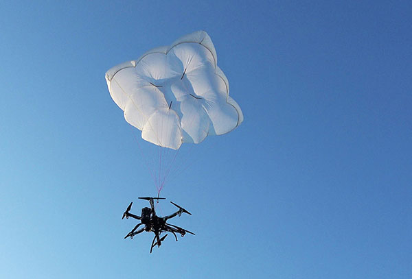
Drone Rescue will present its parachute systems DRS-5 and DRS-10 to the professional public for the first time at Intergeo, at stand 12.0B.112 in Hall 12, Oct. 16-18.
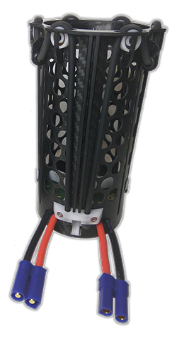
Parachute rescue system DRS-5 is designed for multicopters with a total weight of up to 8 kg. The system consists of a carbon cage in which the parachute is stored, as well as the associated electronics.
The electronics, including the sensors, monitor the flight status of a drone independent of the flight controller. A sophisticated algorithm merges this sensor data, through which an automatic crash detection can be realized, the company said. In an emergency, the pilot no longer needs to react and press an eject button. (Often, this is technically no longer possible anyway, such as with a failure of the radio link.)
Furthermore, the algorithm reacts faster than the pilot: the system ejects the parachute itself. All flight data and movements are recorded in a black box. In an emergency, these can be read out at the request of the customer and made available to insurance companies or authorities.
“Our goal is to ensure that even in an emergency beyond visual line of sight the drone can be safely intercepted. With our parachute system, that is always possible, due to the electronics that are completely separate and independent of the flight controller,” said Andreas Ploier, CEO and co-founder of Drone Rescue. “In addition, our system has the advantage that it manages completely without explosive, pyrotechnical solutions. Consequently we have a system that is considerably lighter, and functions even in a worst-case scenario.”
DRS10 system. (Photo: Drone Rescue)
The reliability of the system has been verified in extensive tests by Joanneum Aeronautics in Graz, Austria. In the framework of the tests, 100 flights were conducted during which the parachute system was ejected.
Half of the flights were conducted with a DJI F550 weighing 1.6 kg. The rest of the tests were performed with the 3.8 kg Vulture, which was developed by the FH Joanneum.
In both cases, the DRS-5 was attached to the side of the main body of the drone. In each of the tests the parachute was ejected at a height of 30 meters. Every test was documented.
Furthermore, the data were saved both in the flight controller as well as in the DRS-5 sensor system. After every 10th test, the parachute system was subjected to a visual examination and checked for possible damage or wear.
“After conclusion of the tests, it can be recorded that all 100 flights were successfully completed,” Ploier said. “In every test the multicopter landed safely. Thereby, the kinetic energy was significantly below the limit of 79 J. All requirements specified by the European Aviation Safety Agency (EASA) were observed.”
Besides the DRS-5, the structurally identical parachute system DRS-10, which is designed for multicopters with a total weight between 5 and 20 kg, will also be presented at Intergeo 2018. “The DRS-10 system functions exactly the same as the DRS-5 and falls back on the same components. These are constructed identically, just oriented for a higher payload. The functioning method of both parachute systems is identical,” Ploier said.
With flight tests for the DRS-5 completed in late summer, the first systems will be delivered to end customers in winter 2018.
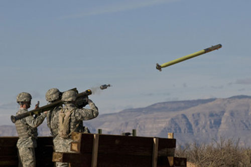
U.S. Army completes qualification testing for new Stinger missile proximity fuze.
The new proximity fuze enables the Stinger missile to destroy a wider array of battlefield threats such as enemy unmanned aircraft systems. (Photo: U.S. Army)
The U.S. Army has completed qualification testing for a new proximity fuze that significantly enhances the combat-proven Stinger missile produced by Raytheon Company.
The proximity fuze detonates the warhead if the missile passes within a certain radius of the target, creating a cloud of shrapnel that eliminates the target.
During testing at Eglin Air Force Base in Florida in April 2017, the upgraded weapon system scored a perfect 100 percent hit rate against a variety of targets. The missiles were shoulder- and vehicle-launched.
The new proximity fuze enables the lightweight, self-contained air defense system to destroy a wider array of battlefield threats such as enemy unmanned aircraft systems by detonating the missile’s warhead near the target, while maintaining its hit-to-kill capability.
“Equipped with a new proximity fuze, Stinger is an affordable, near-term and proven solution for countering emerging threats in the battlespace,” said Kim Ernzen, Raytheon Land Warfare Systems vice president. “Together with the Army, we are putting the most capable Stinger yet into the hands of our brave men and women on the battlefield.”
https://youtu.be/h75hxN-hcMQ
With qualification testing complete, the Army can move toward a near-term fielding under an Urgent Materiel Release. Plans call for the new proximity fuze to be integrated into Stinger missiles as part of a Service Life Extension Program to be conducted at the Army’s ammunition plant in McAlester, Oklahoma.
Combat proven, the Stinger missile has more than 270 fixed- and rotary-wing intercepts to its credit. It’s deployed in more than 18 nations and with all four U.S. military services. The weapon can be rapidly deployed by ground troops and on military platforms, and has been integrated for use on the Apache Attack Helicopter.
Atlantic Microwave, a U.K.-based satellite communications company, has announced the maiden flight of its DSS Satellite Simulator product on board an eight-rotor drone.
Off-air testing of ground- and vehicle-based satellite communications systems has developed into a major industry need with the current explosion of satcom applications in multiple industries, Atlantic Microwave said.
Atlantic’s satellite simulator and loop-test translators were aboard the drone in a first flight in Denmark, using frequencies in the Ku band for proof of concept. Atlantic is also offering similar payloads in Ka band (which delivers greater bandwidth), X band for the military, as well as future Q and V band operations.
“We are in an exciting age where new technologies are shaping our current and future lifestyles,” said Atlantic’s CEO, Geoff Burling.”At Atlantic Microwave, we embrace these advances and seek, innovatively, to create solutions in all kinds of communications industries.”
Atlantic Microwave, based in Braintree, U.K., provides satellite simulation with antenna and cabled-in based products, which have been supplied to major satcom operators, integrators and manufacturers on all continents.
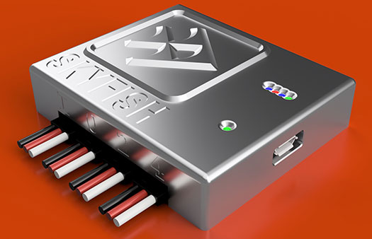
The Skyfish platform is controlled by the tiny SkyNode computer, which integrates with optical, thermal, navigational and lidar devices along with sensors, algorithms and robotics. (Photo: Skyfish)
UAV technology developer Skyfish has introduced a computing platform for commercial drones that fully automates crucial infrastructure inspection and measurement tasks.
The Skyfish platform was unveiled and is being demonstrated at Booth #133 at the Commercial UAV Expo Americas conference being held Oct. 1-3 in Las Vegas.
Skyfish supports DJI and PixHawk flight controllers and other popular drone architectures, as well as 3D modeling software from companies such as Bentley Systems Inc.
Skyfish provides a smarter platform so anyone can fly, inspect and model complex infrastructure with an easy-to-use interface, the company said. The platform also pre-processes the collected infrastructure data and metadata to help create impeccable 3D models.
Available now to selected early-adopter customers, the Skyfish platform comprises:
SkyNode. Application-specific, onboard microcomputer controls the Skyfish system (and any Pixhawk 2.1 or DJI A3-based airframe.)
SkyControl. Flight planning software that facilitates the creation and execution of complex flight plans in a few clicks.
SkyFish Smart Gimbal. Delivers precision angle measurement with encoded motors to capture deep, highly accurate metadata for 2D mapping and 3D modeling.
SkyFish M6 or a DJI Commercial Drone. An expandable and collapsible commercial-grade UAV.
“The Skyfish platform represents a sea change in commercial drone technology for infrastructure inspection, measurement and analysis,” said Mike Barkasi, project manager at Bentley Systems. “For our infrastructure customers that want to enable the benefits of drone sourced data — but need engineering grade accuracy for their 3D modeling — I believe leveraging both the Skyfish and Bentley platforms together is a good answer.”
“As a leader in the unmanned aerial system (UAS) industry since 2013, Vision Aerial’s been waiting for a well-designed, autonomous solution that provides both precision navigation and built-in sensor integration,” said Shane Beams, CEO at Vision Aerial. “Skyfish delivers exactly that.”
A team deployed ground-penetrating radar mounted on drones, showing that the technology can search and locate targets buried deep in glacial ice.
On July 15, 1942, six P-38 Lightning fighter aircraft and two B-17 Flying Fortress bombers encountered a blizzard while supporting the Allied war effort in the British Isles.
The aircraft were forced to conduct an emergency landing on the glaciers of Greenland, and though all the crew members were rescued nine days later, the aircraft were left behind.
After using radar to find areas of interest in 2011, an expedition led by the non-profit Arctic Hot Point Solutions returned to Greenland.
Ground-penetrating radar was integrated with a drone for the survey mission in Greenland. (Photo: Arctic Hotpoint Solutions)
This time, the team deployed ground-penetrating radar mounted on drones, and showed that the technology can search and locate targets buried deep in glacial ice. Aerial surveying was more effective and less risky than working on the ice.
The team extracted hydraulic fluid from 340 feet below the surface, leading to the identification of the buried aircraft as the P-38 Echo piloted by Robert Wilson.
Six undiscovered aircraft — also part of the “Lost Squadron” — remain entombed in shifting glaciers, along with many additional WWII aircraft that went down over of Greenland as they flew between the United States and the European theater.
A future expedition will attempt to excavate Echo, and locate other aircraft of the Lost Squadron.
As Hurricane Florence rattles along the coastlines of the Carolinas and Georgia creating havoc, everything that flies is grounded. Right now the hurricane has slowed to a tropical storm, but flooding is extensive and people have died.
As soon as the high winds subside, expect almost all first response groups to put up UAVs to begin damage assessment. Digital images gathered by these drones will assist forward personnel to direct recovery and rescue operations. FEMA and other search and rescue teams, already in place along the track of the storm, have begun to rescue people by boat and are expected to fly drones over other inaccessible areas to find survivors.
And, of course, a significant part of the coverage we will see over the next week or so will come from drone-borne TV cameras and links to network uplink vans. We should also expect drones to be used for significant data gathering to map affected areas for damage to homes and infrastructure — including powerlines, radio and cellphone towers and distribution centers, waterways, roads and railways.
Let’s hope that the lessons learned and experience gathered during the major storms of last year will help everyone operating drones assist in minimizing the time to rescue people and to speed recovery from this latest hurricane. Later, expect the insurance companies to arrive with UAVs to assess damage and verify claims.
Police forces are using drones…
The law enforcement office in Dauphin County, Pennsylvania, has been using a drone for several months. With more than 13 investigations completed, the drone has helped locate one lost individual and has also supported crime-fighting.
Rather than calling out a manned helicopter for assistance, the police are able to get a drone in the air within 20 minutes at much less cost.
FAA regulations govern how Dauphin County law enforcement officials fly their drone, including a waiver granted to allow night-time operations.
…while Colombia is testing drones to destroy coca plants.
Recent growth in Colombian coca cultivation to 516,000 acres during 2012-2017 came as a consequence of the end of a government program to fumigate coca fields. Crop-duster planes spraying glyphosate had previously reduced Colombia’s coca fields from 470,000 to 193,000 acres during 2001-2012, according to U.S. figures.
Meanwhile, U.S overdose deaths from cocaine are continuing to increase, while rebels and drug traffickers have apparently shot down several crop-dusters.
Lawsuits against the use of the chemical glyphosate have also been successful. Over-spray is alleged to have killed other, legal crops, and opponents also cited a recent ruling in California that awarded $289 million in damages to a groundskeeper who said glyphosate-based weed killers had caused his non-Hodgkin lymphoma.
Because of concerns, Columbian police have been testing drones — flying a couple of feet above the plants to mitigate over-spraying of defoliants — to kill coca crops and reduce the supply of cocaine. Apparently, 10 remotely guided drones, each weighing 50 pounds fully loaded, destroyed hundreds of acres of coca in the first phase of tests. Though common in agriculture for the monitoring of crop growth, it’s thought that drones have never before been used to kill illegal crops. The fumigation appears to be about 90% effective to date.
Nevertheless, in Colombia’s drug zones, soldiers will be needed to partition swaths of coca-producing land and to defend operators from angry farmers and drug traffickers. There are also land mines which will need to be overcome from Colombia’s long rebel conflict and which pose a danger to drone operators.
Counter UAS (C-UAS) systems are on the rise.
The Drone Dome system uses Laser, RF and Radar. (Photo: Rafael)
As fast as drone technology is developing, counter UAS (C-UAS) systems are also being put in place to prevent unwanted drones from penetrating the air above sensitive facilities — by detecting and disabling them. There are purportedly more than 60 such C-UAS systems available in the U.S., with more in other countries including China and Russia.
Systems use various technologies for detection — such as radar, laser, optical/IR, RF “sniffer,” and acoustic. Drones can be disabled by RF and GNSS jammers, by spoofing of both the GNSS navigation or the control link, and can be brought down physically by high-power lasers, nets deployed by other drones, collisions by attack drones, by regular or specialized anti-drone gun systems and even by high-pressure water cannons for very close-in defense. Anti-drone systems include detection and take-down dome-based systems and man-portable drone guns.
SpotterRF C-UAV radar. (Photo: UAS Vision)
The UK government has acquired the Drone Dome C-UAS (counter-UAS), manufactured by Rafael, Israel. Detection is provided by an S-band radar (four radars provide all-round coverage), an electro-optical/infrared (EO/IR) surveillance suite, and a wideband RF sensor.
Drones can be disabled by a high-power laser, an RF jammer, or when very close-in by a high-pressure water gun. The UK system is expected to use jamming to bring down drones and doesn’t include the high power “hard-kill” laser option.
Depending on the size of the intruder drone, the radar detection range is around 3.5-10 kilometers, and the radar may also disable a UAV when integrated with the RF jammer. With an active electronically scanned array antenna, the radar is relatively small and light-weight for both fixed and mobile installations.
The DroneGun. (Photo: DroneShield)
Another C-UAV offering, from SpotterRF, claims to solve the problem of requiring multiple radar elements to achieve 360-degree “dome” coverage. The 3D-500 radar enables full “dome-drone” detection from 0 to 90 degrees vertical and 360 degrees horizontal using a single radar with a 500-meter detection radius, yet weighs only 12 pounds.
Latitude, longitude and altitude of intruder targets are measured within a 1-kilometer diameter hemisphere dome. Following radar detection of an unauthorized drone, the system may be augmented by a slew-to-cue optical/IR camera providing a visual display to an operator — a directional RF jammer on a pan/tilt turret can then be activated to take-down the intruder. The system operates automatically to both detect and disable the drone, or manual control is possible to enable initial operator confirmation of the target before take-down is activated.
DroneShield out of Australia markets a drone detection and mitigation system probably best known for its DroneGun. The DroneGun is a point and shoot device able to disrupt multiple RF frequency bands simultaneously (433 MHz, 915 MHz, 2.4 GHz and 5.8 GHz), taking out the communication link to a drone operator — and also GNSS signals when so equipped — up to 1 kilometer away.
The full DroneSentry detection system integrates a suite of sensors and countermeasures including radar, optical, RF listening, acoustic, thermal and an RF countermeasure transmitter with greater power and range than the portable DroneGun.
Another example is the Rex-1 drone gun. Operating in the 2.4 GHz and 5.8 GHz bands, the Rex-1 rifle-like drone-disabling device is a man-portable jammer developed by Russian Kalashnikov Group subsidiary ZALA Aero Group.
https://youtu.be/Px56KtpZ004
Mapping and survey are becoming a major application for drones.
One such example is 3D mapping of a copper mine in only three days using a fixed-wing UAS.
At an altitude of 1,400 meters, the Erdenet open-pit mine in Mongolia extends 5 x 2 kilometers and is more than 200 meters deep in places. Despite strong winds and even some snow in May this year, one UAS quickly captured geospatial data that enabled three-dimensional modeling of the large, complex site.
Site management is expected to use this initial model as a baseline against which future drone-maps will be compared, and to plan future mine operations.
However, extensive preparations over a two-week period were still required, including the installation of 21 ground control points, positioned using GPS RTK measurements. Re-verification of these points was also required from time to time before the survey, due to changes in the mine from ongoing mine operations, including dynamite blasting.
A MAVinci Sirius UAV was used to gather almost 7,000 aerial photographs which were processed through Agrisoft Photoscan Pro software to produce a detailed digital surface model. All the data collected will be used to create various internal views of the mine for continued mining operations. The mine produces about 26 million tons of ore each year, leading to approximately 530,000 tons of copper and 4,500 tons of molybdenum derivatives.
UAVs make medical deliveries.
Some U.S. medical facilities will soon be participating in a Department of Transportation test program to transport medical samples and supplies by UAV — the object being to obtain test results and medical supplies much quicker than at present. Matternet, Zipline and Flytrex — UAV companies already involved in deliveries by drone — will use several different UAVs in the program, which also aims to set up a number of medical distribution centers.
Matternet has been delivering medical supplies by drone in Switzerland, and Flytrex is focusing on food and package deliveries.
Delivery drone in Kasungu, Malawi. (Photo: AFP)
Meanwhile, Zipline and UNICEF have established an “air corridor” in the city of Kasungu in Malawi to test the transport of medical supplies by drone. Rwanda had previously used UAVs to deliver medication in Africa. Other underdeveloped countries without good ground infrastructure could well benefit by using life-saving drone deliveries for urgently needed medication.
Supporting police investigations, mapping of mines, and coca crop destruction all seem to be good examples of newer uses for unmanned air vehicles. And when policing of drone intrusion is required, looks like there are many new options to detect, disable and even take down unwanted drones. I’d say we seem to be making good progress towards better acceptance and that the industry is starting to grow up.
And let’s all hope that the efforts of all first responders in the Carolinas and Georgia continue through the many weeks of recovery from flooding and damage that are still to come, and that people can soon get back into their homes.
Spry Drone briefly submerges under water to flip on its belly then fly in the air like a bird (PRNewsfoto/Urban Drones)
SwellPro USA and Urban Drones have released a waterproof drone, the Spry, that can briefly submerge like a submarine, float like a boat and fly in the air at over 43 mph.
The Spry features a self-contained camera that can capture video at 30 frames per second and pictures at 12 megapixels. According to the company, the Spry gives users the ability to capture high-resolution video and pictures without compromising speed and agility. It can also wirelessly transmit the video signals to a monitor embedded in its waterproof remote control.
The Spry’s GPS can be activated from the remote control, which has an integrated 4.3-inch monitor to view the Spry’s live video feed. It also boasts advanced flight features, such as hold position, auto follow, object orbit and return to pilot’s position.
“The Spry’s ability to submerge under water and fly in the air makes it the most versatile drone ever created,” said Alex Rodriguez, CEO at Urban Drones. “We’ve only seen this in science fiction movies.”
Urban Drones is a drone technology company located in Florida and SwellPro USA’s partner in the Spry project.
As precision guidance, autonomous operations, high-definition geocoded images and high-volume data processing all improve, drone use will continue to increase. OEM receiver manufacturers, sensor suppliers and data-handling companies play key roles in development, and stand to profit thereby.
In particular, use of drones is growing in land management, construction, mining, and farming. An open-pit mine operation can be supported through detailed drone inspection producing high-resolution images. Processed images and data enable keeping tabs on inventory, site changes over time, identifying best areas for further extraction, and monitoring and managing vehicle movement. These tasks required huge amounts of time in the past. Drone overflight and processing tools condense all the effort as well as producing enhanced results to enable faster and clearer decision-making.
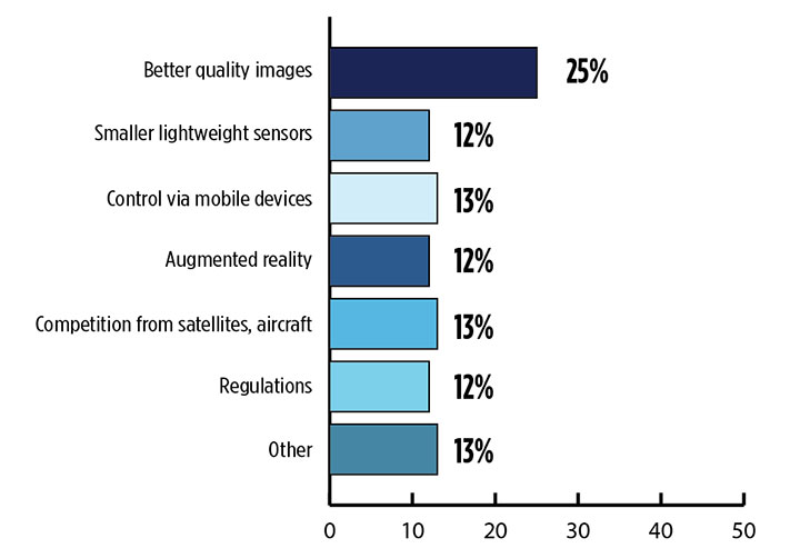
What is the biggest challenge for the UAV industry? (Source: GPS World 2018 State of the Industry survey)
Defense. Surveillance and reconnaissance are probably the biggest military drone applications. Carrying payloads that include color video cameras and infrared night vision cameras, more than 19,000 drones are now in the arsenal of the U.S. Army, Air Force, Marines and Special Ops, and more have gone to other nations’ militaries.
Flying at relatively low altitude, with somewhat limited range and powered by a single quiet electric motor, these drones have become essential in gathering forward-situation intelligence.
Other UAV craft provide higher altitude, longer-duration surveillance and reconnaissance over wider range: up to 20 hours, up to 15,000 feet, more than 60 miles afield. Civilian versions of these craft are in development.
Delivery. Respondents to our survey thought delivery will be a breakthrough application for drones. Amazon has several trials running globably. National civil aviation authorities need to move forward with plans to integrate drones into civilian airspace for this initiative to graduate to full-scale operations and achieve their objective of 30 minutes from order to delivery.
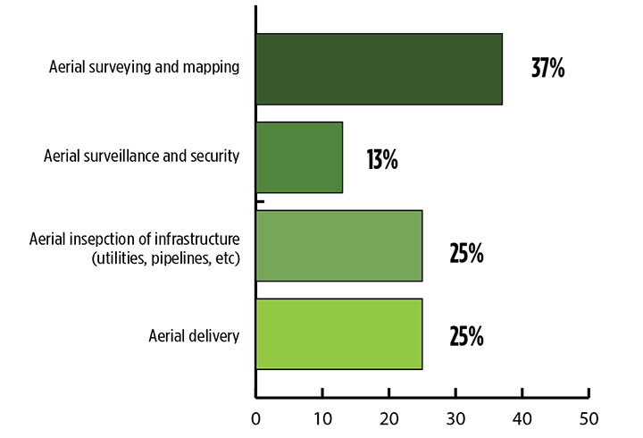
What is the killer app for drones? What professional UAV market sector will most powerfully drive adoption and influence new regulations for unmanned aerial vehicles? (Source: GPS World 2018 State of the Industry survey)
Precision Agriculture. One of the most significant applications which seems to be missing from survey responses is agriculture. Both quadcopters and hybrid fixed-wing/copter drones are in widespread use to capture image data overflying crops, and then process the data and build crop analytics. Graphic results point to how crops can be managed to increase yield.
Making this work is a combination of sensor payloads gathering visual, video, lidar, thermal and hyperspectral data; the secret sauce lies in how the data is processed and presented to farmers. Emphasis is placed on exactly how “green” crops appear when inspected by the various sensors. A number of companies offer services for farmers to optimize crop management.
All these areas are show significant drone growth. Let’s not forget facility, transmission line and pipeline inspection — tasks where drones excel at increasing efficiency and decreasing costs.
For more results from the 2018 State of the GNSS Industry, see this page.
Tony Murfin is a GNSS aerospace consultant with several decades experience at leading companies in the GPS/aviation and OEM sectors.
The inaugural European Drone Summit will be taking place Oct. 15 in Frankfurt, Germany.
According to event sponsor UAV DACH e.V., the conference will give operators, manufacturers and public authority representatives the chance to gather and discuss the potential modes of operation and applications that are opening up for professional drone service providers and companies in light of the unmanned aircraft industry’s new European general aviation regulation.
Keynote speakers at the event will include Peter van Blyenburgh, UVSI; Max Scheck, Vereinigung Cockpit; Jules Kneepkens, EASA a.D.; Martin Brandenburg, DJI; Andreas Lamprecht, AIRMAP; and Jörg Seebach, DeDrone. The Intel Drone Group’s Anil Nanduri will also present a keynote speech.
“We are delighted that high-ranking experts from different companies, some of whom are even competitors, have accepted our invitation to come on board,” said Michael Wieland from UAV DACH e.V. “Global players’ first-hand experience and solutions offer added value to everyone taking part.”
The goal of the European Drone Summit is to channel ideas and decisions relating to unmanned aircraft systems (UAS) in order to highlight how unmanned aerial vehicle technology can be used now and in the future by representatives of various sectors, organizers said. The summit will take place at the same time as Intergeo, which will take place Oct. 16-18.