Photogrammetry software developer SimActive has announced Correlator3D version 6.3 with an expanded UAV enterprise offering. A new floating licensing option allows computers on the same network to seamlessly borrow licenses from a pool, increasing transferability for enterprise requirements.
Because of the worldwide client base of Correlator3D, SimActive has also introduced multi-language support with this version. Users can now operate the software in multiple languages, along with the default English option. Examples of the increased selection include Chinese, Japanese and French.
“With users in over 50 countries, including many with enterprise requirements, we continue adding features to meet the immense industry demand for the product,” said Louis Simard, CTO of SimActive. “With processing speed at least 10 times faster than entry-level UAV software, Correlator3D is the only affordable global enterprise solution.”
For a live demonstration at the Capturing Reality Forum (Nov. 23-25, Salzburg, Austria), visit booth 37 or send an email to [email protected].
Sentera LLC, a designer of sensors, software, and unmanned aerial vehicles (UAVs), has been granted a Section 333 exemption from the Federal Aviation Administration (FAA) to operate multiple types of commercially available UAVs. Applications for these systems include crop survey, infrastructure inspection, geospatial mapping and other aerial imaging missions.
“We are excited to receive the exemption,” said Sentera CEO, Eric Taipale. “While most exemption holders focus on providing revenue-generating flight services, Sentera flies primarily to demonstrate our products to customers and to gather and analyze aerial data which helps us enhance our OnTop Platform, a data management system designed specifically to support the thousands of images collected during a typical UAV flight.”
Sentera’s exemption for both fixed-wing and quadcopter UAVs ensures the company can capture a wide range of data types that are relevant to customer applications, including very high-resolution visual, multispectral, and thermal imagery, as well as specialized non-image information. Customers use Sentera input data to perform many tasks, such as developing planting and crop management advice for growers, building 3D models of buildings, structures, and terrain for asset owners, and monitoring environmental regulatory compliance for public agencies.
Comprehensive data management solutions are crucial to successful UAV inspections, asset audits, safety inspections, agriculture data collections, and point-cloud collection activities.
“Clients use a myriad of UAV-captured data types to increase safety, assess crop health, and boost ROI (return on investment),” explained Taipale. “Sentera already provides some of the most precise sensors and leading UAV solutions in the industry. Our Section 333 exemption allows us advance our OnTop Platform more rapidly, which ultimately helps our customers manage all of this data most efficiently.”
The FAA authorization allows Sentera to fly UAV platforms built by Lockheed Martin, DJI and Sentera.
Hasselblad Group and DJI have announced a corporate partnership through DJI’s acquisition of a strategic minority stake in Hasselblad. DJI also joins Hasselblad’s board of directors.
The partnership will allow opportunities and new ways of combining the technical knowledge and inventive spirit of the two industry leaders in their respective fields, according to a news release from the two companies.
“We are honored to be partnering with DJI, the clear technology and market leader in its segment,” said Perry Oosting, Hasselblad’s CEO. “DJI and Hasselblad are equally enthusiastic about creativity and excellence, and we are looking forward to sharing technical expertise and paving the way for future innovations.”
Hasselblad and DJI will each focus on their individual strategic directions and related growth opportunities, with marketing and branding platforms continuing to delineate the two companies. Hasselblad cameras and equipment will continue to be handmade in Sweden, and DJI will continue to make products in Shenzhen, China.
“Hasselblad and DJI share a passion to provide creative people with cutting-edge, inventive technology to help them take visual storytelling to the next level,” said Frank Wang, DJI’s Founder and CEO. “With this partnership, we combine our strengths to further push the borders of what’s possible in imaging technology.”
Hasselblad has a history of aerial photography — its technology was used in space on several NASA missions, including the first landing on the moon and several of the Apollo missions.
The City of Denver has contracted with the Sanborn Map Company Inc. to collect high-resolution, full-motion video imagery of the city’s seven public golf courses and its Aqua Golf facility.
Sanborn employs a commercial-grade unmanned aircraft system (UAS) from Denver-based Leptron Unmanned Aircraft Systems. The UAS is capable of producing unprecedented accuracy and resolution, including high-quality, engineering-grade digital terrain models exceeding 2-inch accuracy; multispectral frame imagery at sub-centimeter resolution; and crisp, vibration-free video. Earlier this year, the Federal Aviation Administration granted Sanborn a Section 333 Exemption, which permits the firm to offer commercial UAS services nationwide.
“We launched our new golf website earlier this year and now we look forward to adding the Sanborn imagery,” said Leslie Wright, Denver Golf director of marketing. “Our course locations range from densely populated urban areas to mountainous terrain with elevations above 7,000 feet. We also had a very tight window in which to perform the work. Considering these diverse challenges, Sanborn has approached the project with a high degree of professionalism and has been great to work with.”
The city will use the images for marketing, as well as to give golfers a bird’s-eye view of every hole with realistic fly-overs down each fairway from the tee box to the green. The city’s Overland Park Golf Course is the oldest operating course west of the Mississippi River, according to a news release from Sanborn.
“Sanborn’s UAS technology is a great fit for a host of customers,” said Sanchit Agarwal, director of mapping operations. “Among them are police and fire departments, agricultural operations, utilities, oil and gas concerns, emergency response managers, local government, mine operators and the media.”
Sanborn acquired this bird’s-eye view video of the 17th hole at Denver’s Evergreen Golf Course with its commercial-grade UAV.
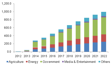
The global commercial UAV market is expected to reach $2.07 billion by 2022, according to a new study by Grand View Research Inc.
Increasing applications in agriculture and law enforcement are expected to drive commercial UAV industry growth over the forecast period. Commercial drones are finding applications across various industry verticals globally. Every industrialized country in the world is making investments in drones, thus driving the scope and technological developments for applications in the commercial UAV market.
Drones are contemporary alternatives for activities where human life cannot be risked. Such drones find applications in various industrial verticals including military, homeland security, retail and agriculture. The demand is significantly higher for military applications, although commercial applications are progressively catching up.
Aviation regulatory bodies such as the Federal Aviation Administration (FAA) have imposed restrictions on the use of such drones taking into consideration the difficulties in managing such huge air traffic and the safety of the citizens. However, the FAA is known to be undertaking an initiative to accelerate the UAV approval process for public safety agencies and broaden access to civilian organizations for a variety of commercial, industrial and other applications.
Further key findings from the report suggest:
Rotary blade drones accounted for more than 70 percent of the global market share owing to their easy maneuverability and compact design. Moreover, such single and multi-rotor drones equipped with rotary blades have Vertical Take-Off and Landing (VTOL) abilities for applications, where there is limitation of space for fixed blade drones to take off. The development of advanced hybrid UAVs that operate on non-conventional sources of energy and nano, small miniature drones serve multiple applications across various industry verticals.
Government applications dominated the global commercial UAV industry constituting more than 40 percent of the market share in 2014. Increasing applications in law enforcement, security and surveillance, R&D activities, infrastructure, disaster management, and environmental studies have led to an increased demand for such unmanned aerial vehicles from the concerned government agencies. Innovative applications across agricultural sector have made it the fastest growing application segment, which is projected to grow at a CAGR of more than 18 percent from 2015 to 2022. Special agricultural drones can take snapshots of fields and help in analyzing crops. In addition, fix winged drones can be used for applications such as watering, spreading seeds, fertilizers, and pesticides over large farm fields that drastically reduce the time required and increase the efficiency.
North America is expected to grow at a CAGR of more than 16 percent over the forecast period on account of concentration of major drone manufacturers and increasing applications in the commercial sectors in the region. Governments and technology giants across the world are striving hard to provide internet to the people as a basic necessity. Facebook Inc. recently acquired Ascenta, a drone manufacturer for its pilot project to provide internet in remote areas using drones as movable wireless access points. Relaxation in regulations and increasing use of drones in law enforcement activities in Europe have led to the regional industry growth.
Major industry participants include AeroVironment Inc., BAE Systems, DJI, Elbit Systems, Parrot SA, Israel Aerospace Industries, The Boeing Company, and Textron Inc. Manufacturers resort to mergers and acquisitions as their key growth strategy to make their presence felt in the industry. Augmented funding, technological collaborations, and government agencies are expected to emerge as critical success factors for industry growth.
Grand View Research has segmented the global commercial UAV market on the basis of product, application, and region:
Commercial UAV Product Outlook (revenue, USD billion, 2012-2022)
Fixed wing
Rotary blade
Nano
Hybrid
Commercial UAV Application Outlook (revenue, USD billion, 2012-2022)
Agriculture
Energy
Government
Media & Entertainment
Others
Commercial UAV Regional Outlook (revenue, USD billion, 2012-2022)
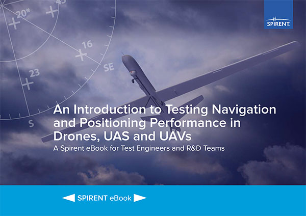
According to Spirent, “The use of unmanned aerial vehicles (UAVs) is starting to take off in commercial and military sectors. The potential applications of UAVs are many – including survey, mapping, media reporting, delivery, reconnaissance, conservation and search & rescue. What’s more, in some cases the cost of using UAVs has been found to be up to 98.8% cheaper than manned aircraft.
“But it is still early days, and for designers and developers of UAVs, there are many challenges in bringing viable models to market and putting them to work.”
The ebook looks at those challenges and sets out the main positioning and navigation considerations that UAV test teams should incorporate into their test regime, Spirent said. It covers:
GNSS/GPS performance considerations — how to evaluate positioning capabilities of UAVs
UAV design considerations, including where GNSS receivers should be placed, the type of antenna needed and more
Which environmental/external factors need to be considered, such as wind, temperature and multipath effects
PrecisionHawk and Genera Energy have partnered to develop new analysis algorithms specific to improving the efficiency and quality of sustainable biomass crop production and distribution. The algorithms will convert raw aerial imagery collected by drones and satellites into an actionable report for biomass crop farmers. The tools will be publicly licensed for use in the DataMapper software platform.
Within the DataMapper software platform, Genera will license the completed tools in the Algorithm Marketplace, DataMapper’s library of sophisticated algorithms for data analysis. The store automatically interprets data collected from a drone’s geographic information system during flight. The Genera algorithms will add to the currently available lineup of algorithms serving the agricultural industry such as assessing plant characteristics, identifying pests, and monitoring disease pressures.
Since 2008, Genera Energy has been an industry leader in biomass supply and supply-chain services. The first group of research tools to be developed under the new partnership will focus on lignocellulosic crops, core to Genera’s expertise.
“Working with PrecisionHawk to develop advanced data collection and analysis tools elevates commercial-scale biomass supply chains to the forefront of technological innovation for crop management, risk reduction, and efficiency,” said Sam Jackson, vice president of Business Development at Genera. “PrecisionHawk is the leading company in remote sensing in a variety of industries, including agriculture. Partnering our agronomic knowledge and skills with their outstanding technology platform is a win not only for us, but for the entire biomass industry.”
“This partnership is a great opportunity to develop decision support tools that provide a more sustainable and efficient path for energy production,” said Allison Ferguson, director of Education and Research Partnerships at PrecisionHawk. “Genera Energy has built an impressive reputation in agriculture and energy, and we look forward to offering this suite of useful solutions for the betterment of the industry.”
At Unmanned Systems Defense, warfighters had the opportunity to learn about new technologies from government contractors and see demos in the exhibition hall. (PRNewsFoto/AUVSI)
ARLINGTON, Va. — Despite shrinking defense budgets, existing and emerging worldwide threats will make robotic and autonomous systems’ development important for decades, said officials at the Unmanned Systems Defense 2015 conference held here Oct. 27-29.
Because America has been at war for more than 14 years, unmanned technology has been developing at a rapid rate, perhaps even faster than emerging autonomous commercial systems. The replacement of even manned aircraft has some in the military establishment wary, but others know it’s only a matter of time before most vehicles, surface ships and aircraft are unmanned.
Navy Secretary Ray Mabus said that the F-35, which has been controversial because of its cost and capabilities, may be the last manned fighter aircraft.
Mabus acknowledged the rise in autonomous vehicles not only in the military, but in the civilian world. “Our grandchildren may never have to drive a car. I can’t wait for driverless cars,” he said.
The Navy is so high on unmanned systems that it recently named retired Marine Brig. Gen. Frank Kelley as deputy assistant secretary of the Navy for unmanned systems.
Like the other services, the Navy is experimenting with aviation systems that are inexpensive and small. It is developing swarming drones that are designed to overwhelm a target. Mabus said one of the cool drones that the Navy is developing is called Kraken, which operates underwater, then explodes past the surface to operate in the air.
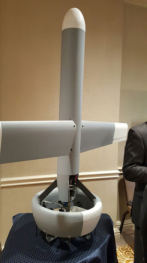
A V-Bat UAV from Martin UAV. Applications include aerial mapping, border patrol, shipboard operations and others.
The Air Force also is developing small drones that can be launched and recovered by a larger aircraft after a mission is complete.
While the meeting was filled with government bureaucrats with the requisite PowerPoint slides detailing how long programs will take, they did say that the services are plowing ahead with autonomous technology that many of their civilian counterparts say are decades away.
Convoy Operations
An Army initiative called Leader Follower includes rudimentary autonomous convoy operations capability with GPS and base mapping systems, autonomous steering and braking. Army program managers say the program is in staffing, but should be approved in a few months.
The follow on to Leader Follower is a full-blown Automated Convoy Operations capability that would allow any manned system, including tanks and mobile artillery, to operate autonomously. Automated Convoy Operations are at least two-to-three years behind the Leader Follower program, Army officials said.
Other Army programs include route clearance systems to defeat underground improvised explosive devices and caches and mine rollers.
With all the new autonomous technology, at least one speaker said the first question should be why an unmanned system is needed at all, given its high cost and long lead times for rollout. “Does the technology enable a [service member] to fight better, or does it just get in the way?” said Lt. Col. Hank Lutz, U.S. Marine Corps joint staff.
Plans to Replace Aging Unmanned Systems
Lt. Gen. Michael Williamson, U.S. Army deputy to the assistant secretary of defense for acquisition, said the service is divesting its aging robotics and drone systems, which means future contracts for defense companies. “In 14 years of war, we have rode this equipment pretty hard,” he said. “We believe in modernization, but also looking to buy new systems, which is a new shift in order to gain a competitive advantage over our enemies, who are leveraging unmanned systems.”
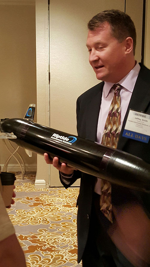
Jeff Smith, president and CEO of Riptide Autonomous Solutions, holds an unmanned undersea vehicle that has GPS sensors and antenna.
The big mantra from the military program managers and senior officials is having an “open architecture” that includes a control segment that works with both manned and unmanned systems. Williamson also echoed the need for standardization, but went further by saying the services should have a list of standards and one place, a facility, to ensure components actually work together.
While the “we want an open architecture” theme was in virtually every speaker’s presentation, one said that there needs to be a balance between the time a product is ready and its interoperability. “The Taliban’s [Program Objective Memorandum] cycle is a lot shorter. Don’t tell me that [your product] is plug and play,” said John Coglianese, U.S. Special Operations Command director, unmanned aerial systems.
DoD Reaches Out to Smaller Businesses, Silicon Valley
Realizing a need to assess new technologies and partner with innovative companies, the Defense Department recently established the Defense Innovation Unit, which is based in the San Francisco Bay area. The office is small with only a few personnel, said George Duchak, who was recently named director.
Duchak acknowledged that some companies suffer from government fatigue in that they see the same presentations over and over. By being out in the Silicon Valley, Duchak’s personnel can be more receptive and listen, rather than talk at companies. His office is made up of people who seek out new technology and vendors, serve as a conduit to local labs and assess companies who want work with the government, among other activities.
“We are kind of in a honeymoon period [with private companies]. It has been interesting finding companies where their patriotism aligns with whether or not they are going to make money,” Duchak said. “Google has been pretty receptive, not so much with Apple.”
Another group, the National Advanced Mobility Consortium, looks to match technology to defense needs for smaller companies looking to do business with the government. “We are trying to show how to engage nontraditional companies,” said Bill Thomasmeyer, National Advanced Mobility Consortium consultant. Thomasmeyer said it’s tough for a small company or individual entrepreneur to go through the complex government procurement cycle. “They are used to Silicon Valley, which has a 90-day cycle. The Federal Acquisition Regulation is 4,000 pages,” he said.
Currently, NAMC has 274 members, a third of which are not defense companies, Thomasmeyer said.
Future of GPS and Location Technology for Unmanned Systems
Virtually all unmanned systems, from drones to autonomous vehicles, use GPS location technology and advanced mapping. As systems evolve, and enemy threats become more sophisticated, new requirements are emerging.
“All of our systems use GPS, but we need to operate in a GPS-denied environment,” said Capt. Aaron Peters, U.S. Navy program manager for expeditionary missions.
Other program managers said what’s also needed is GPS units that feature 3-D navigation for autonomous systems.
In addition to basic positioning and navigation of drones and autonomous vehicles, the Air Force is using location technology to geo-locate damage from shell holes at airfields they use in war zones.
SkyPixel, an aerial photography community run in cooperation with DJI, has announced a drone photography competition. The 2015 SkyPixel Photo Contest is accepting entries starting Monday, Oct. 26, at 00:00 Hong Kong time (GMT+8). Prizes include cash and DJI drones and related equipment.
The contest invites both budding and professional aerial photographers to enter a selection of their best work. The competition is split into two groups, Professional and Enthusiast, each with their own awards for the following categories: Beauty, Unique Dronies, and Drones in Use (aimed at showcasing drones in the air), in addition to an overall Grand Prize.
To celebrate the rise and popularity of aerial photography, the Popular Award will be given to the contest’s 10 most popular photos, based on number of likes received on SkyPixel. Winners will be announced on Jan. 7, 2016.
SkyPixel users can submit their entries at the competition page.
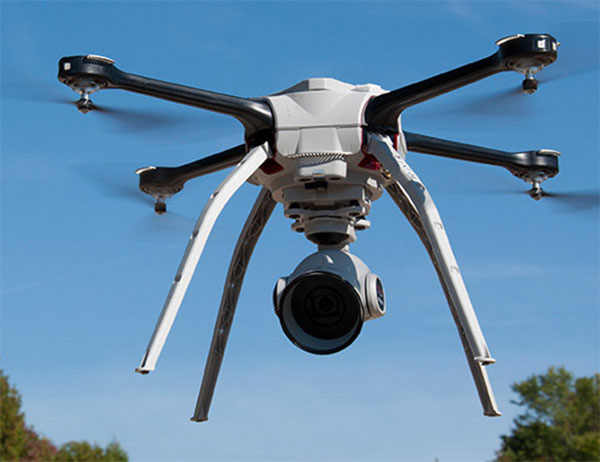
Aeryon Labs is partnering with Microsoft on its new Microsoft Advanced Patrol Platform (MAPP) vehicle. Microsoft has chosen Aeryon’s SkyRanger UAV to demonstrate aerial image and data capture for MAPP.
Aeryon Labs is a provider of small Unmanned Aerial Systems (sUAS) for military, public safety and commercial operators worldwide.
“Law enforcement organizations throughout the world rely on Aeryon sUAS to collect aerial intelligence wherever and whenever they need it,” said Dave Kroetsch, president and CEO of Aeryon Labs Inc. “Including SkyRanger within the MAPP vehicle rounds out the comprehensive suite of technologies and highlights the value of aerial intelligence for ground-based personnel.”
Aeryon Labs’ SkyRanger UAV provides real-time intelligence to law enforcement. (Photo: Aeryon Labs Inc.)
MAPP will connect its drivers to helpful and easy-to-navigate information, Aeryon said. Currently, patrol officers spend vast amounts of valuable time bound to their cars, clicking between windows on bulky, often dated laptops. MAPP will consolidate the many elements officers must keep track of — providing dispatch information, driving directions, suspect history, a voice activated license plate reader, a missing persons list, location-based crime bulletins and statistics, a feed of shift reports and more.
For first responders, surveillance teams and investigators, high-quality aerial imagery provides the real-time intelligence needed to assess a situation immediately, ensure safety on the ground, and capture detailed evidence and forensics. By integrating aerial images from Aeryon sUAS with other cutting-edge hardware and software solutions, the MAPP program sets a new technological standard in policing and helps officers operate with better awareness, efficiency, mobility and safety.
Aeryon Labs is showcasing the integrated solution at the IACP 2015 law enforcement and public safety conference, being held Oct. 25-27 in Chicago.
The Unmanned Aircraft Systems (UAS) Center has teamed up with the University of Cincinnati to conduct research and development on systems necessary to execute precision flight control algorithms for small UAS. Outcomes from this research are targeted to help emergency responders but may also be leveraged for other industrial purposes. The small UAS leased by the UAS Center is a rotocopter that weighs 15 pounds and has a payload capacity of 10 pounds.
The FAA granted a two-year Certificate of Waiver or Authorization to the Ohio/Indiana UAS Center and Test Complex. Testing of the aircraft will take place at Wilmington Air Park in Wilmington, Ohio.
“We will continue to support safe and cost effective research and development efforts across the state in partnership with the FAA, providing the foundation for this rapidly emerging industry,” said Ryan Smith, UAS director for the State of Ohio.
Once this technology is developed, the University of Cincinnati plans on transitioning it to industry. “The type of research being conducted right here in Ohio is what will help the UAS industry grow. Interested Ohio businesses can leverage this technology for commercial purposes,” Smith said.
The Association of Unmanned Vehicles Systems International (AUVSI) estimates the UAS market in Ohio is projected to be a 2 billion dollar industry with a potential to create 2,500 jobs over the next 10 years.
EHang, a UAV (unmanned aerial vehicle) technology company, will launch a new consumer drone on Nov. 4, with a flash sale on starting the same day on the company’s website, which is displaying a countdown clock for the launch.
With the Ghost Drone, EHang introduced a significant step forward in making drone flight an accessible reality for millions of consumers around the world. The company is dedicated to bringing easy, intuitive and user-friendly methods for controlling drones to the masses. The Ghost’s largest contribution to this effort has been eliminating the complexity of using a radio-control transmitter by creating a first-of-its-kind pilot system controlled entirely through the EHang mobile app, making drones more easily accessible by everyone.
EHang also announced it had acquired its own independent factory production lines in the company’s new headquarters in Guangzhou, China.