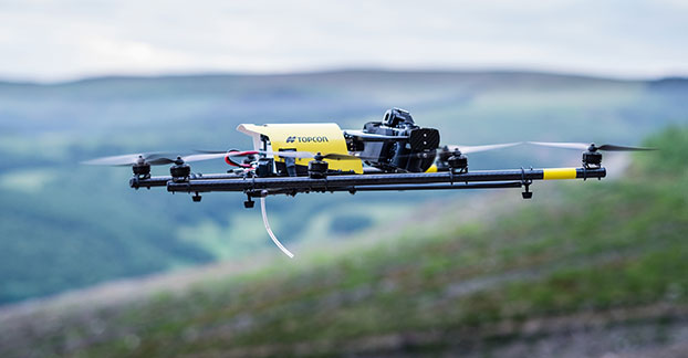
Topcon Positioning Group has added a rotary-wing unmanned aerial system (UAS) to its mass data-collection solutions line. The Falcon 8 — powered by Ascending Technologies — is designed for inspection and monitoring, as well as survey and mapping applications.
“Rotary-wing systems provide the perfect solutions for small-scale sites and projects for which flexibility of takeoff and landing or an oblique perspective is required,” said Charles Rihner, vice president of the Topcon GeoPositioning Solutions Group. “The Falcon 8 offers the flexibility to maneuver in small spaces and can cope with challenging environments often presented in inspection and monitoring. It is also well suited for smaller mapping or modeling projects up to 85 acres that require high-resolution imaging.”
The Falcon 8 features new AscTec Trinity technology, an autopilot safety feature that provides three levels of redundancy for protection against performance drop or loss of control. Three IMUs (inertial measurement system) synchronize all sensing data and identify, signal and compensate when needed.
Two models are available — the GeoEXPERT for surveying, modeling and mapping projects, and InspectionPRO for industrial inspection and monitoring applications. The GeoEXPERT includes a HD RGB camera payload, while the InspectionPRO features an HD RGB camera and infrared sensor combination.
“Both versions offer easy deployment and operation with real-time video and data monitoring capability, navigation software for planning and optimizing flights, as well as photo-tagging and desktop software to quickly generate high-quality and easy-to-edit material,” said Rihner.
The Falcon 8 complements the Topcon Sirius Pro fixed-wing UAS, providing large area accurate mapping without the requirement for traditional ground control.
Air Line Pilots Association, Int’l (ALPA) is the newest supporter of the Know Before You Fly campaign, an initiative to promote the safe and responsible use of unmanned aircraft systems (UAS).
“Over the course of ALPA’s history, we have been a part of nearly every significant safety improvement in the airline industry, and have helped to make airline travel the safest mode of transportation in human history,” said Captain Tim Canoll, president of ALPA. “As a strong supporter of this UAS safety campaign, we will continue to promote and champion all aspects of aviation safety.”
The Know Before You Fly campaign was created by the Association for Unmanned Vehicle Systems International (AUVSI) and the Academy of Model Aeronautics (AMA). The campaign was launched in December 2014 in partnership with the Federal Aviation Administration (FAA) to provide UAS users with the information and guidance they need to fly safely and responsibly.
“ALPA’s support is significant and demonstrates how the airline pilot and unmanned aviation communities can work together to make the airspace safer for all users,” said Brian Wynne, president and CEO of AUVSI. “AUVSI’s members and ALPA’s members share a common commitment to the principles of airmanship that help foster a culture of safety.”
AMA President Bob Brown added, “The ties between model aviation and commercial aviation run deep. Model aviation has been a stepping stone to successful aviation careers. Many airline pilots report being influenced by model aviation early in life. Today, safety is a core principle shared within the aviation community.”
ALPA joins 23 other organizations that support Know Before You Fly, which include retailers, manufacturers, and distributors of UAS as well as several organizations representing the manned aviation community. For information, visit KnowBeforeYouFly.org or follow @FlyResponsibly on Twitter.
Denver International Airport and the Federal Aviation Administration (FAA) are partnering to raise awareness about safe unmanned aircraft operations.
The agencies teamed up on a public service announcement that will run on the video towers in the airport’s main terminal. The PSA uses the “No Drone Zone” slogan to drive home the point that flying an unmanned aircraft near a manned aircraft is illegal and dangerous. It refers viewers to the FAA’s unmanned aircraft website and to the knowbeforeyoufly.org website for further information and guidance on flying unmanned aircraft safely and responsibly.
The PSA will air all day today following its unveiling at an unmanned aircraft safety press event that the airport organized and hosted. After that, it will air for two weeks surrounding the winter holidays — a time when many people will be getting drones as gifts.
Denver also will post the PSA on the airport website so it will reach travelers every day of the year.
The FAA has partnered with leading unmanned aircraft industry and hobbyist groups in the Know Before You Fly education campaign, and the campaign materials are now featured in product packaging for several types of UAS.
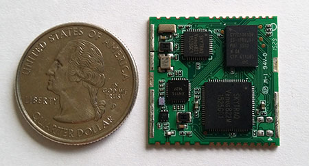
SkyTraq’s S2525F8-BD-RTK multi-constellation RTK receiver is designed for UAV and mobile platforms.
SkyTraq Technology, a fabless GNSS positioning technology company, is introducing the S2525F8-BD-RTK, a cost-effective, low-power single-frequency RTK receiver for unmanned aerial systems and mobile platforms requiring centimeter-level position accuracy.
The S2525F8-BD-RTK multi-constellation RTK receiver supports GPS, BDS, QZSS, and SBAS, simultaneously tracking up to 28 satellites. With its 25 x 25 millimeter form factor, 300-mW power consumption and 3 gram weight, it is designed for any outdoor applications requiring high-precision RTK positioning.
S2525F8-BD-RTK supports both base station and rover modes. As a rover, it receives RTCM 3.0 or 3.1 data from a base station, or raw measurements from another S2525F8-BD-RTK receiver serving as base station, and performs carrier phase RTK processing to achieve relative positioning with 1 cm + 1 ppm position accuracy within 10-Km baseline.
Its compact evaluation board has serial interface connector supporting direct connection to Ardupilot and Pixhawk autopilots for UAS testing. A Bluetooth 2.1 module is included on-board to simplify outdoor evaluation using Bluetooth-connected smartphone or tablet to receive remote base station data via NTRIP client software over the Internet.
S2525F8-BD-RTK engineering sample, datasheet, reference design and evaluation kit will be available in October. Volume production delivery to customer begins in November 2015.
The editor of the Geospatial Solutions monthly newsletter, Eric Gakstatter, has two speaking engagements at the upcoming Commercial UAV Expo, which will be held Oct. 5–7 in Las Vegas. See him live at Caesar’s Palace!
On Tuesday, Oct. 6, at 4:10 p.m. he will address “GPS/GNSS Technology Options for Commercial UAV.”
There are several flavors of GPS/GNSS technologies to choose from when designing and deploying UAVs. Is 3-meter accuracy OK? How about sub-meter or centimeter? How realistic is it to have high-precision GPS/GNSS receivers on UAVs? This presentation will discuss different GPS/GNSS technologies and methods of achieving sub-meter and centimeter accurate GPS/GNSS receivers on commercial UAVs.
Immediately following his presentation, he’ll participate in a panel discussion on “UAVs in Survey and Mapping,” in the same room, with Lewis Graham of GeoCue Group and Eric Andelin from Agerpoint.
Lorenzo Martelletta of PIX4D gives an overview of the company’s Pix4D image processing software while at INTERGEO 2015, which was held Sept. 15–17 in Stuttgart, Germany.
Pix4D image processing software is a mapping and modeling solution that can convert thousands of images into georeferenced 2D mosaics and 3D models.
Every fall thousands of geospatial professionals are drawn to Germany, like bees are to honey, for the largest geospatial exhibition on Earth. This year in Stuttgart, more than 17,000 attendees from 92 countries are flooding the halls of the Stuttgart Exhibition grounds located adjacent to the Stuttgart International Airport. Attendees are being treated to a vast array of geospatial technology treats from 500+ exhibitors representing 30 countries.
Unmanned Aerial Vehicles
I recall a few short years ago, there were only a handful of UAV vendors at the entire exhibition. Now, there is hardly an aisle that does not contain a quad-copter, fixed-wing aircraft or a UAV-related accessory. The growth of UAVs into the geospatial market growth has been the most explosive geospatial technology introduced in the past 25 years, the span of time that I’ve been involved in the geospatial industry. It’s over the top — there is so much hype surrounding UAV technology that there might be more sellers than buyers. It’s become so crazy that there are vendors presenting UAVs that haven’t even been built yet! It reminds me of the days that Atari would announce a new game system nine months before it was ready to ship.
In the UAV space, I wonder which companies are actually making money. My guess is very few. A few of the big players like DJI, Parrot (owns senseFly) and 3D Robotics are doing well, plus a few others. But it’s an unhealthy buyer/seller ratio. Something’s going to give.
The sensefly eXom UAV in flight.
Today’s winners in the UAV market are companies like Pix4D, Agisoft and others who make mission planning and image-processing software for UAV-collected data. They are smart in that they aren’t competing against the hundreds of other UAV airframes on the market; they work with data from most of them. Following is a 3D example of what the Agisoft software can create given a bunch of images shot with a $1,500 DJI Phantom at 200-foot elevation.
The resolution is very good, and you’re able compute material volume such as the piles of aggregate on the west side of the river.
Inexpensive RTK
In the past, I’ve written a lot about inexpensive RTK GNSS receivers. At the InfoAg Conference a couple of months ago, Swift Navigation announced it is testing its $500 RTK receivers. At INTERGEO, CHCNav introduced L1 RTK GNSS in a mobile phone (check our website for a video on that). It’s not capable of centimeter accuracy yet, but quickly heading in that direction. NVS Tech is also pushing sub-$500 L1 RTK GNSS modules.
It’s interesting because L1 RTK is nothing new. That technology was first introduced almost 10 years ago, and wasn’t accepted very well. Now, the UAV phenomena is breathing new life into L1 RTK receiver technology because it’s driving the requirement for low-cost, high-precision GNSS receivers. L1 RTK GNSS are finally getting the love they were looking for nearly 10 years ago.
In case you weren’t able to make it to INTERGEO this year, Joelle, Michelle and I are shooting a bunch of short (~2-minute) videos at various exhibition booths while we are here. We hope to give you a flavor of the geospatial technology being offered this year in Stuttgart.
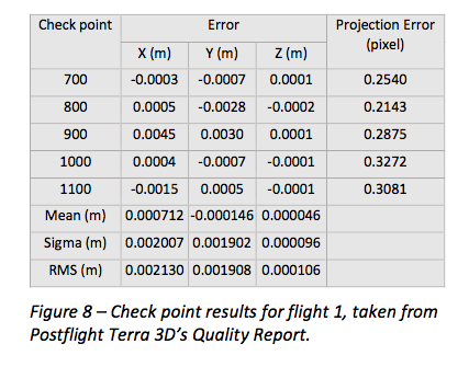
senseFly has published a white paper named “Generating highly accurate 3D data using a senseFly eXom drone” which presents the results of two photogrammetric land surveys of a construction site. The project was completed earlier in September using two senseFly eXom close mapping and inspection drones, and the announcement was made during INTERGEO, held Sept. 15–17 in Stuttgart, Germany.
The results demonstrate that 3D point clouds produced with an eXom quadcopter can reach a global precision comparable to that of a total station survey and meet the typical accuracy requirements of construction projects, according to a news release from senseFly.
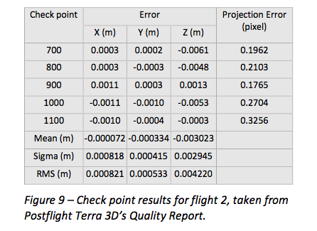
The first eXom survey (figure 8) achieved 2.1 millimeter accuracy in X, 1.9 millimeter in Y and 0.1 millimeter in Z (RMSE). The second eXom survey (figure 9) achieved 0.8 millimeter (X), 0.5 millimeter (Y) and 4.2 millimeter (Z).
“This degree of absolute accuracy from a drone is unparalleled and positions the eXom as a surveying instrument that is comparable in performance to standard total stations,” said Andrea Halter, senseFly’s co-founder. “These results were due, in part, to the high 38 MP resolution and sharpness of the flight’s images, captured by the main camera inside eXom’s TripleView head. Add to this image quality the ability to operate close to the terrain and the introduction of highly precise ground controls and you have a recipe for exceptionally accurate 3D data.”
Two eXom drones flew separate survey missions at an altitude of 14 meters above the site, achieving an average ground sampling distance (GSD) of 2.2 millimeters, senseFly says. All the flights were completed using the drone’s Interactive ScreenFly flight mode, whereby the UAV (unmanned aerial vehicle) is controlled using a handheld ScreenFly controller connected to senseFly’s eMotion X flight planning and control software.
This flight mode’s “cruise control” feature, combined with its auto-trigger function, enabled each of the eXom drones to survey the 1,100-square-meter site in a single flight. Meanwhile, the live on-screen feedback from the drone’s five different navcams and ultrasonic proximity sensors helped the operator ensure that no contact was made with either the on-site crane or any the trees surrounding the complex site, senseFly says.
“This project’s flights took place at 14 meters above the ground, but with the eXom’s Distance Lock feature we are able to safely fly just 4 meters away, so it isn’t unrealistic to think that the accuracy we achieved could be improved still further.”
To download the eXom accuracy white paper click here.
DJI is offering two new cameras for its DJI Inspire 1 professional aerial camera platform.
The new Zenmuse X5 is a commercially available micro four-thirds (M4/3) camera designed specifically for aerial use. With a large sensor, aerial image makers will be able to capture up to 13 stops of dynamic range, making it easy to capture high-resolution 16 megapixel photos or 4k, 24fps and 30fps videos in complex lighting environments.
Zenmuse X5 users will have more options for capturing images in the sky through additional supported lenses and full wireless aperture and focus control. At the time of launch, the Zenmuse X5 will support four interchangeable lenses, including the DJI MFT 15mm f/1.7 ASPH lens, Panasonic Lumix 15mm G Leica DG Summilux f/1.7 ASPH lens, Olympus M.ZUIKO DIGITAL ED 12mm f/2.0 lens, and Olympus M.Zuiko 17mm f/1.8 lens. While the Zenmuse X5 is in flight, pilots can adjust both focus and aperture via the DJI GO app or through DJI’s previously announced Follow Focus system.
The Zenmuse-X5 aerial camera.
The camera’s lightweight 340-gram (0.75-pound) body integrates with DJI’s signature three-axis Zenmuse gimbal technology, creating effortlessly smooth video and stabilized long-exposure photos (up to 8 seconds).
“The professional applications of the Zenmuse X5 are almost endless,” said Eric Cheng, DJI’s director of Aerial Imaging. “In addition to shooting professional-quality photos and 4K video, the new camera can be used to create high-quality aerial maps and 3D models, and can also help industrial teams get even more detail from their aerial imaging pursuits, for example, in utility inspection using a drone.”
DJI also announced the Zenmuse X5R camera, which shares the same sensor and lens compatibility with the X5, but records video both to an onboard microSD card as well as to a removable 512GB solid state disk (SSD) on the gimbal’s top plate. The Zenmuse X5R records CinemaDNG (RAW) video to the SSD, and opens up lossless 4k video recording in a compact form factor with video bitrates averaging 1.7 Gbps (with a maximum of 2.4 Gbps).
The Zenmuse X5R also offers a brand-new D-LOG mode that offers a broader array of color correction options in post production.
To support the management of Zenmuse X5R Cinema DNG files, DJI will release software to edit and convert RAW camera footage. CineLight, which will be available when the Zenmuse X5R camera is released later this year, simplifies users’ workflows by offering offline proxy editing before converting the CinemaDNG files to ProRes.
“In order to achieve the quality of video produced by Zenmuse X5 and X5R, pilots used to have to spend many thousands of dollars for large, complicated aerial equipment,” said Frank Wang, DJI CEO and founder. “Now, pilots can simply mount the Zenmuse X5 series cameras to their Inspire 1, put on their props, get up in the air, and have full control of their shot while in flight. This saves valuable time on film sets and makes high quality imaging for industrial applications smaller, lighter and easier to manage.”
By mounting a small, easy-to-install bracket, the Zenmuse X5 series cameras are fully compatible with existing DJI Inspire 1 platforms as an interchangeable option for the Inspire 1’s standard Zenmuse X3 camera.
The Zenmuse X5 is available for pre-order at store.dji.com for $4,499 (€4,999), including a DJI Inspire 1 and DJI’s MFT 15mm F1.7 ASPH lens, and will begin shipping before the end of September. The Zenmuse X5R will be available in Q4 2015 for $7,999 (€8,799). Both can be purchased as stand alone cameras with, or without lens. More information can be found at dji.com.
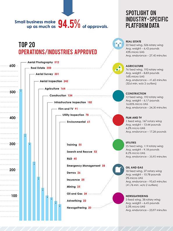
The Association for Unmanned Vehicle Systems International (AUVSI) today released a report that finds more than 25 types of business operations have been approved by the Federal Aviation Administration (FAA) to fly unmanned aircraft systems commercially in the National Airspace System (NAS). According to the report, aerial photography received the most exemptions followed by real estate and aerial surveying. The report also finds that exemptions have been approved in 49 states.
“These figures show that businesses across every industry sector have been waiting to use UAS for years and are excited to finally get this technology off the ground,” said Brian Wynne, president and CEO of AUVSI. “From inspecting bridges and power lines to filming movies and supporting emergency services, the applications of UAS are virtually limitless and enable researchers, public agencies and businesses to do things that were previously considered to be impossible.”
In May 2014, the FAA announced it would consider granting exemptions for certain low-risk commercial UAS applications under Section 333 of the FAA Modernization and Reform Act of 2012. Since then, the agency has received more than 2,700 requests and approved more than 1,400 petitions.
AUVSI analyzed the first 1,000 exemptions approved by the FAA. Specifically, the report finds:
The approved exemptions cover more than 25 types of business operations, with aerial photography receiving the most approvals with 512. Real estate followed with 350 exemptions and general aerial surveying with 301 exemptions.
Exemptions were approved for operators from 49 states. California received the most with 114, followed by Florida with 97 and Texas with 82.
California companies also manufactured the most platforms mentioned in the approvals, totaling 140. Florida followed with 19. In all, 22 states house manufacturers of platforms approved in the first 1,000 exemptions.
More than 90 percent of the first 1,000 exemptions were granted to small businesses.
Companies that received exemptions generate at least $500 billion to the U.S. economy annually and represent more than 600,000 jobs.
While the Section 333 process has continued to unlock the potential of UAS technology, AUVSI emphasized that regulating by exemption is no substitute for finalized rules.
“For the full potential of the UAS commercial market to be realized in the U.S., the FAA needs to finalize its small UAS rule as quickly as possible,” Wynne said. “Once this happens, we will have an established framework for UAS operations allowing anyone who follows the rule to fly. The positive effects of the regulation will be felt across the whole country.”
An economic impact study released by AUVSI in 2013 found the UAS industry will create more than 100,000 new jobs and more than $82 billion in economic impact within the first ten years following UAS integration.
The complete study, including state-by-state data, is available.
SBG Systems joins YellowScan to present a lightweight lidar with inertial and GPS for UAVs. The new product will be presented at the INTERGEO trade show in Stuttgart, held Sept. 15-17.
The YellowScan lidar is designed for fixed or rotary-wing UAVs, with an embedded Ellipse-E, a miniature inertial navigation system from SBG Systems, which helps obtaining a clear and accurate point cloud.
The UAV market is continuously growing, especially for professional applications like 3D surveying. Developed for such applications, YellowScan’s R&D team has worked closely with researchers and professionals in industries such as construction, surveying, mining and natural resources to create a comprehensive, high-performance and easy-to-use LiDAR.
Ellipse-E. The ready-to-use YellowScan is operational at up to 75 meters and delivers a highly dense point cloud accurate to 10/15 centimeter. The solution includes a lidar with a ±50 degree angle that measures 40,000 points per second, an Ellipse-E inertial navigation system coupled with a centimeter-level RTK GPS, an on-board computer, and an integrated battery.
The Ellipse-E miniature inertial navigation system by SBG Systems.
Once mounted on the drone, the user pushes the yellow button and YellowScan is ready to survey. LED lights give useful information on YellowScan state, for instance if the GPS is receiving RTK corrections or not. The user can launch the UAV and begin the survey. Once the task accomplished, a USB stick is used for downloading the data. An office software visualizes the point cloud in a few clicks, before opening it in an industry specific software like Terrasolid, AutoCAD or ESRI.
The YellowScan research and development team was searching for a high-performance, light and ITAR-free inertial navigation system for motion compensation and data georeferencing. They tested the Ellipse-E, the new miniature inertial navigation systems from SBG. Weighting 12 grams as an OEM version, it provides roll-and-pitch data accurate to 0.2 degree. The heading is accurate to 0.5° with only one antenna. Indeed, the heading computation relies on GPS and accelerometers data. This method is used when GPS positioning is widely available and punctuated by frequent accelerations, such as turns. The R&D team found the test results satisfying, and a point cloud highly clean. “We are very satisfied with this little Ellipse-E. It perfectly matches our technical needs, and we even gained 5 percent on the total weight of the YellowScan,” said Tristan Allouis, CTO at YellowScan.
Ellipse-E Coupled with External GPS Receiver. The Ellipse-E inertial navigation system is able to connect to any survey-grade GPS receiver and to fuse in real-time GPS position with inertial information. Ellipse-E maintains a reliable position even if GPS masks occur. In this application, the Ellipse-E is coupled with the AsterX-m OEM card from Septentrio, a receiver that uses GPS and GLONASS constellations and works with all types of RTK reference stations.
At INTERGEO, YellowScan will be in booth # F8.014, and SBG Systems will present the Ellipse-E at booth # G4.079.
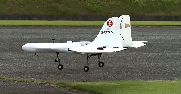
Sony is developing an unmanned aerial vehicle that lifts off and lands vertically like a helicopter (also known as a VTOL craft for vertical take-off and landing.) The VTOL drone is being developed with a Tokyo robotics firm under a collaborative company called Aerosense.
The drone can carry up to 22 pounds, fly continuously for two hours, and reach a speed of 106 miles per hour. Sony is developing it for business customers, who would use it for “measuring, surveying, observing and inspecting” as soon as next year, so it will likely carry different types of instruments, depending on the task a customer requires.
The video below shows a prototype flight on Monday.
Aerosense, created this month, is a joint venture between Sony and Tokyo-based startup ZMP Inc., which specializes in autopilot technology. The venture is part of Sony’s efforts to move beyond its core consumer products into enterprise markets. Aerosense will offer services such as inspecting aging infrastructure and surveying land that is difficult to access. The drones would be piloted automatically based on input from users about which areas they want surveyed.