iXBlue, a navigation and positioning company, is providing 70 Marins M7 to equip 35 Royal Navy major surface ships and submarines as part of the Navigation Compass Programme.
The decisions to equip both the Queen Elizabeth-Class Aircraft Carriers and the fourth Astute-Class nuclear-power submarine with iXBlue’s Marins inertial navigation system (INS) were the first steps made by the UK Ministry of Defense toward the adoption of iXBlue fiber-optic gyroscope technology.
The ministry awarded a five-year contract awarded to Lockheed Martin UK, iXBlue’s strategic partner, for iXBlue’s inertial technology.
The 70 Marins M7 INS will replace the obsolete gyro systems on board the Royal Navy ships which include Type 23 Frigates, Hunt and Sandown Class mine countermeasure vessels and submarines. They will be integrated by Lockheed Martin UK within the compass system installed on board.
“We conducted a detailed assessment of all available possible partners along with their proposed technologies,” said Robert Kramer, vice president of Lockheed Martin UK – Integrated Systems. “By precisely understanding the Royal Navy expectations and assessing their views on the industry leading suppliers, it clearly appeared that iXBlue’s solutions best fitted the needs in terms of performance, capability and cost.”
The Marins family of military-grade FOG INS (M3, M5 and M7 models) are the latest additions to iXBlue range of naval products. They offer performances and reliability that meet the requirements of the demanding navies. Marins M7 model offers a drift of less than 1 nautical mile in 72 hours of surface GNSS-denied or submarine-dived navigation.
“We are very grateful to the Royal Navy for such a decision that demonstrates through a fair and open competition iXBlue’s INS excellence in terms of performance, reliability, lifecycle costs and versatility. This success relies on iXBlue core values: innovation, excellence and a strong commitment to the user,” said Olivier Cervantes, iXBlue vice president for sales and marketing.
Such a milestone contract opens up bright prospects for iXBlue in the field of military inertial solutions, Cervantes said.
NM Group is nearing completion on an aerial mapping project covering more than 16,000 kilometers of United Kingdom rail network.
In 2014, NM Group was engaged to map the rail assets with a mix of high-tech laser measurement and imaging equipment, as part of a project to improve asset maintenance, operational effectiveness, efficiency and safety.
The project used a mix of specially commissioned lidar and high-resolution multi-angle cameras mounted on helicopters, carrying out aerial operations and ground-control activities over a four-month period and completing it before winter. The survey information was rapidly transported to NM Group’s Technology Centre in Knaresborough, North Yorkshire, where a team of specialists have been converting nearly a petabyte of raw data into a wide range of terrain, asset and imaging outputs.
“I am incredibly proud of the way our team has responded to this large and challenging project, completing the data capture within an unprecedented timescale and producing a high-quality output that will serve the rail network for years to come,” said NM Group’s CEO Kevin Jacobs.
NM Group’s contribution to the program provides the geospatial fabric on which other layers are overlaid, the basis for asset location mapping and the start point for the design of upgrades and modifications. Traditionally, this information would have been created by a visit to the site by a team of surveyors.
The new method will significantly reduce the need for future field work and trackside access. It will also facilitate more efficient maintenance, allowing crews to identify and access assets more safely and efficiently than in the past, via apps on a range of mobile devices, NM Group said.
NM Group is a specialist service provider of asset management, surveying and mapping solutions to sectors including energy transmission and distribution and road and rail transport. Applying a range of remote sensing and geospatial technologies, the company offers a full range of services from data acquisition through to analytics and web applications for wider access to information.
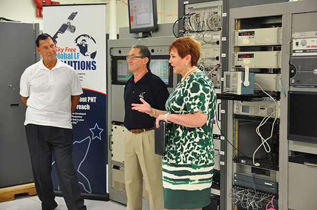
(fFrom left) Congressman LoBiondo, UrsaNav CEO Chuck Schue and Harris Division President Pam Drew. (hoto Credit: Andrei Grebnev, UrsaNav)
As of June 19, eLoran is on the air in the United States. The low-frequency signal emanates from a single station, a former U.S. Coast Guard Loran Unit in Wildwood, N.J., which sports a 625-foot signal mast that has been out of action for five years. The signal is receivable at distances of up to 1,000 miles.
The facility began generating eLoran pulses at the press of a command button by Congressman Frank LoBiondo (R, N.J). Present for the ceremonial start of a 12-month demonstration and research program under the aegis of the Department of Homeland Security were project participants Charles Schue, CEO of UrsaNav; Pam Drew, president of Harris Information Systems; and Dana Goward, president of the Resilient Navigation and Timing Foundation.
Brief remarks delivered at the turn-on collectively made the key points that:
GPS services are essential to national and economic security, yet are vulnerable to disruption.
The eLoran navigation and communications signal has features that are complementary to GPS, making it difficult to disrupt; further, it could be an important part of enabling UAVs to fly safely in our airspace.
The U.S. Federal Radionavigation Plan cites not being critically dependent upon a single system for positioning, navigation, and timing as a national policy objective. The plan specifically identifies eLoran testing as an important step toward reaching that objective.
The two engineering companies, UrsaNav, a supplier of eLoran technology, equipment, and services, and Harris (which recently acquired Exelis), provide funding and technology for the tests supported by the U.S. Coast Guard, Department of Defense, Department of Homeland Security and other federal agencies under a Cooperative Research and Development Agreement (CRADA) announced in May.
The team will evaluate eLoran as a potential complementary system to GPS, exploring the capabilities and use methods of eLoran in depth to identify all strengths, capacities, and potential vulnerabilities of the technology. One goal of the CRADA is to reduce the size, weight, cost, power needs and other aspects of Loran, similar to what has evolved with GPS.
“This is a phoenix arriving. We have the opportunity to add 2015 technology to the older idea,” said Schue of UrsaNav, once Coast Guard commanding officer at the former Loran station. “A prudent mariner always has two systems to navigate.”
Dana Goward, also a retired Coast Guardsman whose non-profit Resilient Navigation and Timing Foundation is working on the project, stated that eLoran can attain positioning accuracy of six meters or better.
“We will explore many places eLoran can be deployed where GPS isn’t available such as deep canyons, through buildings, in foliage and under water,” added Harris Corp.’s Drew. “We’re involved with unmanned aerial drones, and eLoran could be key. There are applications for civilian and military uses.”
In this GPS World exclusive video, Admiral Thad Allen, former commandant of the U.S. Coast Guard, discusses PNT alternatives to GPS for navigation, including eLoran and the activation this week of the signal on the eLoran tower in New Jersey.
eLoran in Europe
Matters have moved a little further along in Europe. In 2013, the General Lighthouse Authorities of the UK & Ireland (GLA) established prototype eLoran Initial Operating Capability (IOC) in the United Kingdom, where eLoran now delivers PNT data at the 10-meter level from a network of high-power, low frequency, terrestrial transmitters.
“To get high accuracy from eLoran requires accurate calibration of Additional Secondary Factor (ASF) through measurement,” according to paper delivered at the Institute of Navigation’s 2015 Pacific PNT meeting. “Can eLoran Deliver Resilient PNT?” was authored by Nick Ward, Chris Hargreaves, Paul Williams, and Martin Bransby of the GLA.
The older Loran-C system suffered from significant positioning bias errors due to a number of radio frequency signal propagation delay factors, they write. “The Primary Factor (PF) is due to the signal travelling slower in air than free-space, the Secondary Factor (SF) is due to the presence of the Earth’s surface and the electrical properties of the oceans. Additional Secondary Factor (ASF) is due to the additional electrical resistance encountered by non-seawater terrain, land, mountains, deserts, and so on. PF and SF can be modeled, but to get high accuracy from eLoran requires accurate calibration of ASF through measurement.
“To do this,” they continue, “ASF surveying and mapping has been conducted along the port approach channels at Aberdeen; along the Firth of Forth; Middlesbrough; Hull and the Humber Estuary Traffic Separation Scheme (TSS); Harwich and Felixstowe; The ports of London, Medway and the approaches past the London Array wind-farm and also through the Dover Straits.
“To complement these services, seven differential-Loran (DLoran) Reference-Stations, one located close to each of these survey areas have been established. These stations monitor the time of arrival of the received eLoran signals, and generate differential-corrections that are broadcast via the Anthorn Loran Data Channel (LDC), to account for temporal variations in these ASF maps.
“Making use of these ASF maps, combined with the locally-produced differential corrections, can allow a maritime user of eLoran IOC to obtain position accuracy of the order of 10m (95%), within a radius of 30 to 50 km of the DLoran reference station.”
eLoran can deliver Resilient PNT and this has been demonstrated on several vessels.
Seamless handover from primary (GPS) to secondary (eLoran) positioning source has been successfully implemented.
Surveying and mapping of ASF has been carried out for several major ports and the required levels of performance demonstrated.
DLoran reference stations to correct for short-term, temporal variations have been installed and commissioned.
Good levels of performance have also been demonstrated for coastal voyage phase away from the ASF surveyed areas.
eDLoran in Rotterdam. The July 2014 issue of GPS World presented a cover story showing results of a newer version, enhanced differential Loran (eDLoran), yielding position accuracies of approximately 5 meters.
Potential GNSS Back-up Improves to GPS-Level Accuracy
A new enhanced differential Loran system demonstrates 5-meter accuracy not achievable by the current DLoran system, and requires less expensive reference stations. A prototype tested in Rotterdam’s Europort area uses standard mobile telecom networks and the Internet to reduce correction data latency — a key source of error — by one to two orders of magnitude.
By Durk van Willigen, René Kellenbach, Cees Dekker, and Wim van Buuren
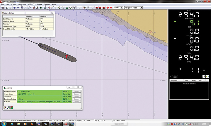
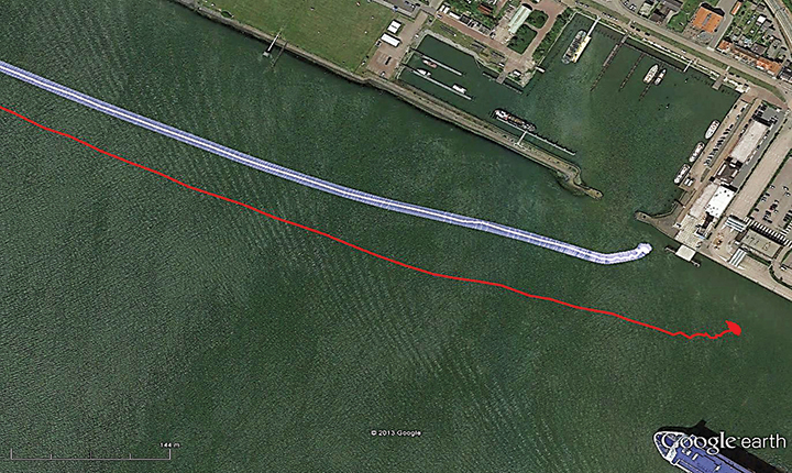
Figure 12. The large ship symbol (grey) is derived from the GPS-RTK receiver of the Rotterdam pilots. The width of the ship symbol is 10 meters and the speed-over-ground was 11 kts. The red triangle is generated by the eDLoran receiver and remains between the required ± 5 meter limits for eDLoran.Figure 13. The red track is based on raw eLoran data without any corrections. The transparent blue line is made by GPS-RTK and is widened to 10 meters giving the required ± 5 meter limits of eDLoran. The white line is output from the eDLoran receiver which stays within the borders of the 10 meter wide transparent blue line.
The GLA authors from the UK give a perspective on the Rotterdam project, as follows:
“A compatible system (eDLoran) has been developed for operation by ships’ pilots on the Europort approach to the Port of Rotterdam.
“However, Loran is a regional system dependent on international collaboration. The 9 transmitters in northern Europe are operated by Denmark, France, Germany, Norway and the UK.
“Both Norway and France have declared an intention to cease Loran transmissions at the end of 2015. Moreover, France intends to dismantle its Loran infrastructure in 2016. Arrangements for the commercial operation of the infrastructure are being investigated, but this depends on some form of regional agreement. The European Union appears to have no policy for resilient PNT, the European Radio Navigation Plan having twice been drafted but never published. The view seems to bee that the introduction of Galileo will achieve resilient PNT, which it will not.”
And Elsewhere
South Korea is implementing a national eLoran service, and it is understood that similar plans are being considered in Russia and China.
Ship management company EuroShip Services Ltd. has installed eLoran as a backup to GPS to ensure the safety of its vessels operating off the coast of the United Kingdom.
The trial installation may lead to implementation across the full fleet of 16 vessels managed by Euroship, working routes in Northern Europe. The land-based radio navigation system is intended to seamlessly take over in the event of a GPS outage. EuroShip plans to simulate GPS outages to test eLoran provision of position, navigation and timing data automatically.
Euroship Services is one of the first ship managers to trial eLoran as a back-up to its GNSS. The company manages vessels owned by Cobelfret. They are mostly shortsea vessels, operating in and out of port, frequently in congested waters and with bridge teams that rely heavily on bridge systems for situational awareness.
Euroship managing director Frank Davies told Lloyd’s List that the company has so far been impressed with the first trial system on one of the company’s vessels. He said that with the company’s vessels entering and exiting large European ports, crews have even noticed distorted GPS signals while going under bridges.
Ford Motor Company and Telogis have expanded their exclusive partnership to bring Ford Telematics powered by Telogis to Ford’s commercial customers in the United Kingdom first, with other European markets to follow later this summer. Ford Telematics uses real-time information from Ford vehicles to enable businesses with workers in the field to have insight into vehicle location, driver behavior and fuel consumption.
The telematics can save companies up to 20 percent on fuel, according to a 2012 Frost & Sullivan report.
Since 2011, Telogis has been the exclusive technology provider to power Ford Telematics (formerly Ford Crew Chief) in the U.S. and Canada, with comprehensive and scalable telematics for commercial customers. The UK expansion of the Telogis-Ford partnership leverages the success of Ford Telematics in the U.S. and Canada and will meet the demand from current and new Ford customers in the UK for in the visibility into day-to-day operations including Ford vehicle diagnostics.
“Ford Telematics is an innovative system that can deliver reductions in cost of ownership for businesses that operate Ford’s Transit commercial vehicles,” said Paul McDermott, manager, CV aftersales, Ford of Britain. “Real-time vehicle location and diagnostic data provides fleet customers with a powerful tool to manage their vehicles more effectively and also encourage safer driving.”
Making its debut at the 2015 Commercial Vehicle Show, Ford Telematics will be available to fleet customers in May as a dealer-installed option, offered through Ford’s network of specialist Transit Centres.
Ford Telematics functions by securely transmitting vehicle data and metrics from the vehicle to a dedicated Telogis website via an embedded cellular connection. The telematics system’s ability to access proprietary Ford vehicle data enables operators to track details such as oil change warnings, water contamination in diesel fuel, tire pressure, safety belt usage and airbag status.
“The reality of being able to visualize field staff and the performance of each Ford vehicle — all on one screen — is here,” said Paul Reynolds, automotive director at Telogis. “This visibility enables Ford commercial customers to provide better service for their own customers and run their businesses more productively and efficiently — it’s no longer a ‘nice to have’ but a ‘have to have’ solution.”
Based on the real-time data, the Ford Telematics powered by Telogis software platform delivers a comprehensive range of actionable business information that enables fleet managers to operate their vehicles in the most efficient way and to help ensure drivers are following safe and economical driving practices.
Advances include a suite of more than 80 pre-loaded reports, integration with established business operating systems and fuel card services. Ford Telematics and the Telogis platform also allow for a BYOD (Bring Your Own Device) approach, helping to further reduce hardware costs and increase productivity.
Ford Telematics is compatible with Ford’s latest range of Transit commercial vehicles — including the all-new Transit, Transit Custom, Transit Connect and Transit Courier — as well as the Ford Ranger pickup. Additionally, the same Telogis hardware can be fitted to any other vehicles on the fleet, regardless of manufacturer, allowing informed fleet managers to view the whole fleet in one place, with all the usual driver performance and vehicle tracking information that they expect.
Ford Telematics also provides a gateway to the broader cloud-based Telogis platform that includes a suite of connected vehicle technologies including route optimisation and planning, commercial-grade navigation, work order management and mobile applications to drive additional efficiencies and productivity for mobile enterprises.
“Ford Telematics is another example of Ford facilitating the delivery of smart technology to help our customers enjoy the highest quality, safest and most sustainable operation of commercial vehicles available today,” said Nick Themistocleous, director, Fleet Operations, Ford of Britain.
PD Ports is streamlining the way it shares hydrographic data by using GIS software from British software developer Cadcorp. PD Ports is a port, shipping and logistics company headquartered in Middlesbrough, UK, where it owns and operates Teesport — a major deep-water complex and one of the largest container ports in the North of England.
Teesport is a major deep-water complex and one of the largest container ports in the North of England, handling around 40 metric tons of cargo per year, according to Captain Jerry Drewitt, Harbor Master for Teesport and Hartlepool. “Our first priority is to ensure the safe movement of the considerable amount of river traffic handling this cargo. We rely a lot on hydrographic survey charts which provide an up-to-date record of the depth of the river in berths, approaches, and channels.
“Until recently, our survey department not only carried out hydrographic surveys, but also produced the associated charts. This is changing as we have come to recognize that having surveyors spend time on creating cartography was an unnecessary step in the sharing of hydrographic data, and was actually delaying data publication.“
Drewitt continues, “Hydrographic charts don’t only depict depth data. They also show topography and contextual data about features and boundaries along the river. The position of these features and their attributes, tend to be relatively stable — certainly when compared to the constantly changing topography of the riverbed. We wanted the survey department to concentrate on recording this more dynamic hydrographic data.”
“The less dynamic data — topography, assets, boundaries, Admiralty Charts, Ordnance Survey MasterMap, and aerial photography — can be managed as separate overlays in our GIS, Cadcorp SIS Map Modeller,” Drewitt said.
“We now create composite hydrographic charts by displaying the hydrographic data the surveyors capture, against whatever reference layers are appropriate for a task in hand,” Drewitt said. “This is done in the knowledge that all features will be represented in their true location. We now take XYZ soundings directly from the survey department; drag and drop this data into the Cadcorp GIS, and pass it through a simple filter to indicate three categories of depth zones. Red indicates where the river is too shallow, blue where it is OK, and white where it too deep. “
The outcome of these changes allows the harbor master to share information with the Vessel Traffic Service and pilots much more quickly than before. For example, whenever there is suspected slippage in the river bed, the survey department can be alerted to make a new survey of the affected area. The outcome of their echo-soundings will exported as XYZ files to Map Modeller. The GIS is used to delineate any areas which are deemed to be out of bounds. It is then a simple matter to insert a map into a Word document as a “Shoaling Notice” that can be distributed by email.
Drewitt hopes his deputy harbor masters and pilots eventually will be able to accept map data from Teesport directly in digital form and in real time. However, for the moment, GIS is playing a transitional role somewhere between a map creator and a map viewer. This can be seen in current project where Captain Drewitt is using GIS to match vessels to available berths. He uses the GIS to create and display templates of vessels originally designed as DWG files in AutoCAD. By superimposing these templates, along with tugs and towlines, over maps and charts, it becomes possible to assess the maximum size of vessels that can be accommodated in different berths.
“It is easy to generate a family of templates, and a simple matter to superimpose them against maps,” Drewitt said. “While I can’t yet share them online, I can take map representations to meetings, where the serve an important evidential role.”
“GIS applications don’t have to be complex to deliver real business benefit,” said Mike O’Neil, CEO of Cadcorp. “Teesport have shown this. Their use of GIS isn’t about intricate analysis and modelling. On the contrary, it is about the value you get by bringing together different data sets, quickly and easily. The combined value of these different data sets is often much greater than the sum of its parts.”
Innovate UK (formerly the Technology Strategy Board) and the Natural Environment Research Council (NERC) plan to jointly invest up to £1.3 million to establish new Knowledge Transfer Partnerships in or related to the space sector to help United Kingdom companies to grow in the expanding global space market.
Knowledge Transfer Partnership projects are Europe’s leading program to help businesses improve their competitiveness and productivity through better use of knowledge, technology and skills that reside within the UK knowledge base, according to InnovateUK.
The investments will provide support for 10 to 12 Knowledge Transfer Partnership projects of between six and 36 months, helping to translate the UK’s academic strengths in this area into commercial success.
The competition opens September 15 and is open on a rolling basis for applications until noon on February 11, 2015.
A briefing/launch event for potential applicants will be held at the National Space Centre, Leicester, on September 23, 2014.
Getmapping has posted strong growth for the 2013 financial year. The recently released financial results showed Getmapping post record turnover and profits on the back of strong growth in both the United Kingdom and African markets.
Getmapping is a public limited company, and terms itself the UK’s leading supplier of aerial photography, mapping products and data hosting solutions.
Group turnover was up 34% overall from £3.5m in 2012 to £4.7m in 2013, with the contribution from African operations up 86% on the previous year. Getmapping’s strong performance has also been reflected in its share price which has tripled in the last three years as interest in the company from investors grows, the company said.
Getmapping has been working hard to extend both the range of products and services that it can offer as well as its global reach. In 2013, for example, Getmapping established a new LiDAR division in Centurion, South Africa, which has enabled it to extend its range of services and provide them across a wider geographical area.
While the UK remains a challenging market, Getmapping continues to work hard to retain its strong position. As an example, Getmapping, together with Bluesky, was recently awarded a multi-million pound contract for the supply of geographic data to Central Government organizations. The contract, awarded by the Department for Environment, Food and Rural Affairs (DEFRA), covers high resolution aerial photography, detailed 3D height models and colour infrared imagery for the whole of England, Wales and Scotland. Under the new Aerial Photography for Great Britain (APGB) contract, Getmapping and Bluesky can also provide training, consultancy and workshops to contract members.
“Getmapping delivered strong growth in 2013 across all of our core business streams. The company has invested heavily in new sensor and processing technology and the investment is already delivering strong results which we expect to carry through 2014 and beyond,” said Dave Horner, managing director of Getmapping. “The recent DEFRA contract and winning the aerial photography contract for the Scottish government in 2013 has reinforced our position as the leading supplier of aerial photography services in the UK. The financial results are an endorsement of our strategy, but we won’t be resting on our laurels and aim to continue to improve our performance in 2014 and beyond.”
The General Lighthouse Authorities of the UK and Ireland (GLA) have announced that ships in the Port of Dover, its approaches and part of the Dover Strait can now use eLoran radio navigation technology as a backup to satnav systems like GPS and Galileo. What is considered the world’s busiest shipping route is the first to deploy eLoran to counter jammers and space weather, the GLA said in a statement.
The ground-based eLoran system provides alternative position and timing signals for improved navigational safety. The Dover area, the world’s busiest shipping lane, is the first in the world to achieve this initial operational capability (IOC) for shipping companies operating both passenger and cargo services.
Today’s announcement represents the first of up to seven eLoran installations to be implemented along the East Coast of the United Kingdom. The Thames Estuary and approaches up to Tilbury, the Humber Estuary and approaches, and the ports of Middlesbrough, Grangemouth and Aberdeen will all benefit from new installations, and the prototype service at Harwich and Felixstowe will be upgraded, the GLA said.
Although primarily intended as a maritime aid to navigation, eLoran could become a cost-effective backup for a wide range of applications that are becoming increasingly reliant on the position and timing information provided by satellite systems.
“Our primary concern at the GLA is for the safety of mariners,” said Captain Ian McNaught, Chief Executive of Trinity House. “But signals from eLoran transmitters could also provide essential backup to telecommunications, smart grid and high frequency trading systems vulnerable to jamming by natural or deliberate means. We encourage ship owners and mariners to assess eLoran in this region and provide feedback to the GLA on its performance.”
P&O Ferries has installed an eLoran receiver on its new vessel Spirit of Britain. She will be based at Dover and is one of the largest passenger ships the busy Dover/Calais route has ever seen.
“Accurate real-time positional information is essential for the safe navigation of ships with modern electronic charts,” Captain Simon Richardson, head of Safety Management at P&O Ferries, said. “Satellite navigation systems are vulnerable to degradation of signal strength and our ships have also experienced occasional loss of signal. We welcome the development of a robust alternative to provide redundancy in real-time positional information and we see eLoran as the most effective solution to countering the problem.”
Commenting on the announcement Stephen Hammond, Minister for Shipping, said, “I congratulate the General Lighthouse Authorities on this initiative that seeks to improve navigational safety in what is the busiest shipping channel in the world, through the development and deployment of technology. I look forward to receiving reports of its effectiveness.”
Leica Geosystems Ltd. has signed a formal agreement with Sigma Seven Ltd. to provide improved value data collection and workforce management solutions to the GIS asset collection and management market. The strategic partnership combines GeoField software from Sigma Seven with the Leica Zeno CS25 GNSS tablet computer, allowing high-accuracy satellite position data to be collected with richly attributed data in one system, the companies said.
“Many organizations are demanding the need for better, more reliable information to improve the on-going management and maintenance of their assets,” said Nathan Ward, market segment manager. “This partnership with Sigma Seven with their industry renowned geospatial and work management software will provide a fantastic integrated solution to enable field and office staff to work more efficiently and enhance the quality and effectiveness of their corporate data. A combination of proven capabilities, experience and a long and highly regarded heritage in the geospatial sector, will mean that this partnership will further enhance the solutions in Leica Geosystems’ Asset Collection and Management market.”
Andrew Coleman, Sigma Seven Director adds, “Leica Geosystems is one of the premier manufacturers in the asset collection and GIS industry and they continue to innovate in spatial and measurement technology. By working together I believe we have a unique field mobile proposition, backed up by a shared quality and customer service ethos, that will accelerate the delivery of cost, performance, service and accuracy benefits to our customers.”
Since 2000, Sigma Seven has helped some of the largest utility companies in the UK and developed a range of systems for utilities, government, environmental and engineering customers. GeoField is a powerful mobile data and work management system that enables field workers to access enterprise data at the point of action, Sigma Seven said. An intuitive map-based interface is supported by comprehensive imaging, red-lining, structured workflow, data capture and field reporting facilities.
The Leica Zeno GIS series has been designed and optimized to capture accurate GNSS positions and richly attributed data quickly, even in the most demanding of environments, the company said.
Andrew Coleman, Sigma Seven Director, and Nathan Ward, Market Segment Manager for Leica Geosystems.
Snap Secure, Snap MyLife, Inc.’s cloud-service mobile and personal security application for consumers and families, is now available in the United Kingdom via an automatic carrier billing option provided by mobile payment and analytics leader Bango. The agreement allows Snap MyLife, Inc. to deliver convenience and peace of mind to consumers and their families throughout the UK.
With thousands of mobile devices lost or stolen in the UK each year, mobile security is a concern. The issue is compounded by the fact that new technological capabilities mean people are increasingly relying on their mobile devices to conduct daily activities involving sensitive information, such as banking and personal communications. This leaves them vulnerable if that information falls into the wrong hands when a device is lost or stolen.
Snap Secure addresses these issues and more by providing a broad range of protection for smartphones, including backing up and restoring data; preventing viruses, spyware and spam; protecting and managing privacy; tracking and locating family members in real-time; locating and remotely controlling lost or stolen phones and tablets; and wiping data remotely.
To illustrate just some of Snap Secure’s comprehensive security features, the application enables users to remotely control a lost or stolen smartphone by locking the device to protect important data and contact information or wiping all data contained in the phone to prevent unauthorized access. Snap Secure leverages smartphone GPS technology to help parents keep tabs on their child’s whereabouts by tracking their mobile device location on a map via their web dashboard. Parents can also use the Snap Secure Geo-fence to establish virtual geographic boundaries for their children and receive alerts when a child leaves the area or does not arrive at a specified location within a designated time period.
The Snap MyLife, Inc.-Bango partnership gives UK mobile device users a quick, convenient way to access this critical protection. UK customers can purchase Snap Secure for Android phones and tablets and BlackBerry phones. Fees for the service are added to the users’ monthly mobile phone bill.
“Protecting personal data and securing mobile devices is a concern everywhere as people become more dependent on their technology assets,” said Jiren Parikh, President and CEO of Snap MyLife, Inc. “We’re excited to work with Bango to offer consumers in the UK a complete family and data security solution.”
“Snap Secure offers UK consumers the peace of mind they need to confidently use their mobile devices without concerns about theft, loss or viruses,” noted Ray Anderson, CEO and Founder of Bango. “We’re looking forward to working with Snap MyLife, Inc. to provide customers with a frictionless payment experience, via their mobile operator.”
Snap Secure has been downloaded more than 2 million times. In addition to the UK, Snap Secure is currently available in Italy, Spain, and the U.S. with additional global market launches in process.
GTX Corp has announced today that its patented GPS tracking smart shoe will be commercially available in the U.K and Ireland this month. The Aetrex Navistar GPS shoes will be made under license by comfort footwear maker Aetrex Worldwide, Inc., and will be distributed by Tipp Toes, an Aetrex Worldwide distributor located in Ireland.
The Alzheimer’s Society in the U.K estimates there are 800,000 people in the UK and Ireland afflicted with Alzheimer’s and Dementia who are prone to wandering. Statistics show that if not found within the first 24 hours, more than half may be found seriously harmed. The GPS technology embedded inside comfortable walking shoes designed for seniors were first introduced in the U.S. and Australia. EE, the UK digital communications company, will be the wireless SIM provider for the GPS shoes after having recently signed a global contract with GTX Corp that will enable the shoes to work in more than 50 countries across the globe which utilize the GSM network.
The shoe wearer can be monitored remotely, thereby helping to ensure their safety, providing peace of mind to their caregivers and reducing the cost of remote oversight. The shoes are embedded with a miniaturized proprietary module that contains the locator’s integrated GPS/cellular chipset and the SIM card unique to each wearer. The GPS shoes communicate via EE’s cellular network and sends location coordinates via a wireless data connection, similar to sending SMS messages on a cell phone. If the wearer wanders outside of a pre-set location determined by the caregiver, an SMS or email message will alert the caregiver instantly.
The GPS shoes have been heralded by healthcare and technology authorities around the world and is featured in the “100 Most Important Inventions of Mankind” Exhibit in the National Museum of Science and Technology in Sweden.