The official portrait of HRH The Duke of Edinburgh as Master of Trinity House. (Image: Trinity House)
Prince Philip, technology advocate, championed both GPS and alternative navigation methods during his lifetime.
Prince Philip — the Duke of Edinburgh and husband of Queen Elizabeth II of the United Kingdom — died on April 9 at Windsor Castle in England. He was 99. His funeral will take place April 17.
As the Master of Trinity House, Prince Philip was the U.K.’s authority for lighthouses in England, Wales, the Channel Islands and Gibraltar. Trinity House is also responsible for the provision and maintenance of other navigational aids, such as light vessels, buoys and maritime radio/satellite communication systems.
In its extensive coverage of his death, the BBC aired a radio program in its World Service that mentioned the prince’s knowledge and concern about GPS. “As Master of Trinity House, he was infuriated that people didn’t understand what would happen if GPS were shut down,” said the narrator.
Real Admiral Sir Jeremy de Halpert was Prince Philip’s deputy master at Trinity House. “ Prince Philip from the very beginning understood that it was a single point of failure,” de Halpert told the BBC. “GPS can be jammed very easily… He encouraged us to move ahead and make sure the country has a failsafe backup, which we have done, and it is now operational,” he said.
Below is the section of the documentary where the prince’s support for GPS and a GPS backup is discussed.
GPS World thanks Innovation editor Richard Langley for sharing the material.
The Empire State Building sits atop a massive and solid foundation that hardly anyone ever sees. Above ground it has 2.8 million square feet of offices and hundreds of businesses. It houses 15,000 workers. Yet it would all come crashing down if the underlying and unseen foundation weren’t incredibly strong and dependable.
Timing is the unseen foundation of every networked technology, digital broadcast, financial transaction, electrical grid management and of most navigation systems, just to name a few applications. Yet, as GPS World readers know, signals from our dominant source of timing — GPS — are very faint and easily disrupted.
Short term, localized disruptions happen all the time, and many systems have adapted. A delivery driver using a jammer to hide from his boss is unlikely to disrupt a cell base station as he passes by, for example.
Photo: Georgijevic/E+/Getty Images
But more serious threats are out there. More and more hobbyists are finding ways to spoof receivers. Every few decades the sun flares strongly enough to fry satellites or charge the ionosphere. And because there are so few alternatives, GPS and other GNSS have become huge, tempting targets for adversary nations, terrorists, and sophisticated hackers.
Instead of Manhattan bedrock, our timing foundation is sometimes more like shifting sands.
Systems engineering tells us that, if something is essential, there ought to be two, three or more independent ways of receiving it. Most aircraft, for example, have two or three systems powering the flight controls — because controlled flight is important!
The white paper “A Resilient National Timing Architecture” outlines how the United States can leverage existing infrastructure and provide all citizens two, and many of them three, independent paths to coordinated universal time (UTC).
It proposes a national timing back- bone of mature technologies with very different failure modes — GNSS, eLoran and fiber. This combination will provide rock-solid timing at the 500 ns or better level of accuracy relative to UTC everywhere across the nation, and at 100 ns or better in major metro areas. Users accessing two or more systems would be nearly bulletproof to timing service disruptions.
The National Timing Resilience and Security Act of 2018 mandated a terrestrial system to back up GPS timing. Our white paper provides a path forward.
Complying with the law while benefiting current and future technologies should be sufficient motivation. If it isn’t, we must also realize that not acting on this will continue to place us behind other nations such as the United Kingdom, South Korea, Russia and China — all of whom are actively reinforcing their national timing systems.
The task will not be a simple one. Yet America was able to overcome the expense and difficulties of building GPS, at the time the world’s most refined and complex technology, and put it in space. By comparison, establishing a resilient national timing architecture using existing technology in our homeland would be child’s play.
Timing is essential. It is infrastructure for our infrastructure. If our national timing is weak, so is everything that is built upon it.
We will profit from ensuring our timing is as strong, resilient, and easily accessed as possible.
The Bluesky MetroVista range includes high-resolution imagery combined with high-accuracy, wide-scale 3D models. (Image: Bluesky)
Aerial mapping company Bluesky is releasing its entire catalog of geographically referenced oblique aerial images of cities in the United Kingdom (UK) via a new subscription-based streaming service.
Working with Geoxphere, a specialist in cloud-based GIS, Bluesky will offer MetroVista imagery via an easy-to-use web viewer that also includes measurement tools for detailed analysis of building features, façade details and street furniture locations.
“Oblique imagery offers an unparalleled view of the built environment revealing real world features simply not present in any other type of aerial image or map,” commented Rachel Tidmarsh, managing director of Leicestershire-based Bluesky International. “The MetroVista imagery can be used to inform decision making with time stamped intelligence, and even evidence, as well as improving engagement with colleagues through better communication of ideas. All of this without even leaving your desk!
“However this wealth of information, as you would expect, can present some issues when it comes to storing and consuming data. The MetroVista Oblique Viewer overcomes these issues meaning the value of the data can be realised without the burden of storing, processing or updating.”
With a data-as-a-service (DaaS) solution powered by Geoxphere’s XMAP geospatial cloud technology, the MetroVista Oblique Viewer is a fully managed subscription service meaning there is no need to download or store large volumes of data locally. The MetroVista Oblique Viewer does not require any specialist software, plugins or downloads and, as the data is also managed, newly captured images are automatically added to an account as they become available.
The MetroVista Oblique Viewer has split screen options and rotating views allowing the user to toggle through images to get a 360 degree view of a building. The Bluesky Geoxphere Viewer also includes height and area measurement tools for recording a building height or distance from a feature and its façade area.
Captured using the world’s first large format imagery and lidar hybrid airborne sensor, Bluesky MetroVista imagery collection includes simultaneously captured oblique and vertical aerial photography. The MetroVista datasets also include geographically accurate, photo-textured, mesh models ready for use in 3D GIS, CAD and other modelling software as well as visualisation, gaming and Virtual Reality workflows.
Bluesky has already captured MetroVista data for cities such as London, Birmingham, Manchester, Bristol, Nottingham, Oxford, Cambridge, Brighton, Norwich, Leicester, Derby and Newcastle as well as Bournemouth, Brighton, Cardiff, Doncaster, Eastbourne and Southend.
The European Space Agency (ESA) has awarded a contract to London-based CGI to develop a GNSS Event Notification Service (GENS) capable of monitoring the United Kingdom (U.K.) GNSS spectrum to enable effective alerting and reporting of position, navigation and time (PNT) disruption.
GENS will integrate CGI’s PNT Incident Event Monitoring (PNTIEM) system with existing U.K.-developed sensors from Ordnance Survey’s network (OS NET) of GNSS receivers and GMV NSL’s Detector, GISMO and Strike 3 interface technologies.
Bringing together existing systems will build on proven technologies, reducing the cost of development of a large-scale monitoring network while providing the ability to introduce new services for detecting GNSS events and disruption, according to a CSI press release.
Supported by the OS and GMV NSL, CGI will lead the delivery of GENS using an agile software delivery experience, supported by system design and DevSecOps development and integration skills. An open interface will be offered for future providers of GNSS measurements or spectrum event data.
Alongside the GENS system technical delivery, the National Physical Laboratory (NPL) will develop a GNSS guidance document in partnership with U.K. government departments, agencies, CNI operators, professional institutes, academic institutes and commercial organizations to enable informed requirements development, procurement, deployment and support of HMG GNSS-reliant services.
Reviewed alongside events identified by GENS, the combined offering will highlight and inform stakeholders on risks posed by the loss of PNT services as identified by the PNT Strategy Group Interim Report in April 2020.
GENS will also respond to HMG’s “Satellite-derived time and position: a study of critical dependencies” report which identified the need for mitigation to GNSS disruption and estimated the economic impact to the U.K. economy of a five-day disruption to GNSS at £5.2 billion.
The full GENS system will enable users across both commercial and public sector services to subscribe to be informed of both GNSS quality and interference events for regions of interest. By focusing on these events and the improved understanding of the risk posed by disruption, stakeholders will be better informed to enable them to build system resilience or to respond to the disruption of GNSS within the U.K.
‘‘Detecting and monitoring GNSS is core to better understanding the scale and risk posed by PNT disruption in the U.K. and across all ESA member states,” said Rafael Lucas Rodriguez, technical officer for GENS, European Space Agency. “ESA is supporting CGI to develop effective tools enabling a system to be created utilizing previous ESA and UK HMG work. This will bring direct benefits for U.K. public and private stakeholders.”
“The U.K. is a leading investor in GNSS research,” said Andy Proctor, U.K. lead delegate to the ESA Programme Board for Navigation. “Understanding GNSS spectrum quality is vital for the stability of PNT services in the U.K. This program will help promote and address GNSS disruption affecting PNT services while supporting the U.K.’s thriving space sector and the wider economy.”
“This is an exciting project that brings together CGI’s navigation and spectrum domain expertise supported by scaled agile and DevSecOps delivery experience,” said John Hanley, vice president of secure and assured space solutions at CGI in the U.K. “After talking to both public and private stakeholders for GNSS, it became clear that one of the initial challenges is understanding the scale of PNT disruption. GNSS services touch every part of society across finance, utilities, transport and defense and need to be protected.”
CGI has been delivering complex, mission-critical space software systems for clients across Europe, Asia and North America, supporting satellite navigation, communications, operations and space enabled applications for more than 40 years.
The United Kingdom will explore new options for satellite navigation and timing capability to support critical infrastructure, it announced in a press release.
The Space-Based Positioning Navigation and Timing Programme (SBPP) will explore new and alternative ways to deliver vital satellite navigation services to the U.K. for transport systems, energy networks, mobile communications, and national security and defense.
The SBPP also aims to boost the British space industry and develop the U.K.’s own capabilities in these services.
UK GNSS program reinvented
The new program follows the work of the UK GNSS program, which concludes Sept. 30. UK GNSS began in 2018 as a result of Brexit and the U.K.’s departure from the Galileo program.
UK GNSS is an exploration programme that has developed outline plans for a conventional satellite system as an alternative to American GPS or the EU’s Galileo. The program will now be reset as the SBPP to build on this work to consider newer, more innovative ideas of delivering global satnav and secure satellite services to meet public, government and industry needs.
In 2018, the government announced an 18-month program, led by the UK Space Agency, to develop a conventional GNSS, which could meet U.K. security requirements and support the U.K.’s sovereign space and cryptography sectors.
Work completed by the UK GNSS Programme so far has developed cutting-edge British expertise in areas such as spacecraft and antenna design, satellite and ground control systems, systems engineering and simulation, which have wider applications across the space sector, in addition to supporting specialist U.K. jobs and industrial GNSS capability.
The refocused SBPP program could include technology that supports people’s everyday lives, such as emergency services to locate incidents, financial services companies to regulate exchanges on the U.K. stock market, or energy networks to ensure households receive power. Satellite navigation systems are also necessary to unlocking future technologies such as driverless cars, smart cities and artificial intelligence.
Capitalizing on the ingenuity of British businesses and academics, the program will explore the use of different kinds of satellites at various levels of orbit by exploiting technologies offered by companies at the cutting-edge of innovation such as OneWeb, Inmarsat and Airbus.
A Cabinet Office Study examining the need for a U.K. space-based system for secure positioning, navigation and timing concluded that any solution would need to examine more options and further work is needed to determine what form a potential system takes so it provides value for money.
To meet U.K. industry and government needs for resilient global navigation and timing while also providing value for money to the public, the new SBPP will consider collaboration with international allies to share satellite navigation services, costs and technology.
“Satellites underpin so many of the services that we all use every single day, from precise train timetables on our phones and satnavs in our cars,” said Business Secretary Alok Sharma. “Through our Space-Based Positioning Navigation and Timing Programme, we will draw on the strengths of the U.K.’s already thriving space industry to understand our requirements for a robust and secure satellite navigation system. This includes considering low-orbiting satellites that could deliver considerable benefits to people and businesses right across the U.K., while potentially reducing our dependency on foreign satellite systems.”
“I am delighted to see a further boost to the U.K.’s already thriving space industry,” said Scotland Office Minister Iain Stewart. “The U.K. government works closely with industry and academia to support the sector. We have high ambitions for the U.K. to be a global sector leader. The U.K. government is expanding its plans to understand requirements for a satellite navigation system. Satellite navigation provides the core services that we all use every day such as our mobile networks and is the key to unlocking further technical innovation in the future. This new programme will potentially pave the way for greater independence from foreign systems such as the United States’ GPS or the EU’s Galileo system which will allow greater opportunities for British businesses.”
“Our work to date has developed cutting-edge U.K. expertise in satellite navigation spacecraft, antenna design and control systems, while supporting high-skilled jobs,” Graham Turnock, CEO of the UK Space Agency said. “Now is the time to drive this work further to look into wider, more innovative ways of delivering this important national capability — to help protect our critical infrastructure and put the U.K. at the forefront of the development of new space technologies.”
Currently, the U.K. is entirely dependent on foreign systems for these critical navigation services. SBPP will enable to the U.K. to build on its thriving space industry, home to global players such as Inmarsat, Airbus, Surrey Satellites (SSTL) and others, to become a global leader in space navigation technologies, developing new opportunities for businesses in the U.K. and overseas and creating new highly skilled jobs.
The government has made clear its ambitions for the U.K. to become a globally competitive space power and is taking action through the newly established National Space Council, emerging National Space Strategy and the Integrated Review of Security, Defence, Development and Foreign Policy, to create the conditions for a strong, secure and innovative space sector that delivers for the British people.
A government-backed study from London Economics estimated that sustained disruption to existing satellite navigation capabilities would likely cost the U.K. economy £1 billion per day. Investment in space technology and services will enable the U.K. to build back better, unleashing the country’s global competitiveness and underpinning growth and high-skilled jobs.
News from the British government appears to be a part of the United Kingdom’s diversification away from primary reliance on GNSS for positioning, navigation and timing (PNT) services, and toward a more diverse set of sources.
The nation has previously undertaken establishment of a National Timing Centre for distribution of time from suites of atomic clocks and has long transmitted an eLoran timing signal from a government facility in Anthorn.
Thursday’s press release, titled “Government to explore new ways of delivering ‘sat nav’ for the U.K.,” reinforces the government’s commitment to space-based PNT, but not necessarily from GNSS.
OneWeb satellites
The announcement follows significant criticism in Parliament of the nation’s purchase of a 45% share of the bankrupt communications satellite company OneWeb, with the India’s Bharti Holdings having the majority stake. OneWeb had 74 of its planned 648 satellites in orbit when it declared insolvency. With new ownership and financing in place, it plans to resume operations and launch another 36 satellites in December.
Prime Minister Boris Johnson’s motivation for making the investment was to offset Britain’s post-Brexit exclusion from Europe’s Galileo system. The idea was that OneWeb assets in low earth orbit (LEO) could provide a global British PNT capability.
This concept faced political and technical opposition from the start. Many technologists in the U.K. and elsewhere doubted that the constellation could be easily adapted to provide sufficiently accurate PNT services. The doubts were so serious that the senior career civil servant responsible for signing the agreement to invest in OneWeb took the very unusual step of refusing to do so without written direction from the political appointee she worked for.
Before the OneWeb investment, the U.K. government had been studying establish of its own GNSS like America’s GPS and Europe’s Galileo. Sources say the required investment was much higher than the nation wanted to make and would provide little added capability beyond that available from extant systems.
According to Thursday’s press release, the UK GNSS effort was exploratory and will end this month. It will be “reset” as the Space-Based Positioning Navigation and Timing Programme (SBPP). This project “will explore new and alternative ways that could be used to deliver vital satellite navigation services to the United Kingdom which are critical for the functioning of transport systems, energy networks, mobile communications and national security and defence, whilst boosting the British space industry and developing the U.K.’s own capabilities in these services.”
While the press release is short on detail, it does mention satellites at low earth orbit and that “a wider range of options” will be examined. This could suggest redoubling efforts on getting PNT from OneWeb, and/or investing in regional PNT satellites.
Galileo again?
The press release also says SBPP will “consider collaboration with international allies to share satellite navigation services, costs and technology.” This may signal reengagement with Europe on involvement with Galileo.
Some observers have said that Brexit did not have to automatically mean that the U.K. was excluded from the Galileo project. European Union membership is not required for participation in the European Space Agency which is responsible for Galileo. Switzerland and Norway, for example, are not EU members, but are members of ESA and sit on its governing board.
The U.K. government has been very concerned with PNT and GNSS vulnerability since at last 2012 when large solar flares became part of its National Risk Register. In 2017 a London Economics Report found that a five-day GNSS disruption would cost the nation more than $1.3B per day.
This most recent announcement indicates that Britain is still intent on going its own way and diversifying PNT sources, while still acknowledging the ongoing importance of GNSS and keeping its options open with allies.
Dana Goward is president of the Resilient Navigation and Timing Foundation. He is the proprietor at Maritime Governance LLC. In August 2013, he retired from the federal Senior Executive Service, having served as the maritime navigation authority for the United States. As director of Marine Transportation Systems for the U.S. Coast Guard, he led 12 different navigation-related business lines budgeted at more than $1.3 billion per year. He has represented the U.S. at IMO, IALA, the UN anti-piracy working group and other international forums. A licensed helicopter and fixed-wing pilot, he has also served as a navigator at sea and is a retired Coast Guard Captain.
Mobile GIS Services (MGISS) has been awarded a place on the United Kingdom government’s procurement platform G-Cloud.
Designed to ease the procurement of cloud services by the public sector, the G-Cloud 12 framework makes it easier for customers to find, review and contract MGISS’s advanced geospatial software services through an online digital marketplace. Managed by Crown Commercial Services, it is forecast that successful suppliers, such as MGISS, will receive up to £2 billion in business.
In a parallel achievement, MGISS has also been accredited as a supplier of software, hardware and support services to the utility sector by the supplier assurance company Achilles.
A specialist in mapping and geographic information technology, MGISS also is working alongside organizations such as United Utilities and Northumbrian Water Group and it is hoped that successful qualification under the Achilles UVDB pre-qualification system will help MGISS gain further traction within this sector.
MGISS has also attained the Workplace Wellbeing Charter. Recognizing a commitment to improving the lives of its team members, MGISS received accreditation across a number of facets including leadership, health and safety, mental health and absence management.
“Although recognizing completely different aspects of the business these awards are all significant milestones and accomplishments in their own right and the entire team should be proud of the hard work and commitment they have expended to achieve them,” said MGISS Managing Director and Founder Mike Darracott. “The G-Cloud and Achilles accreditation will put MGISS front and center for the leading players within the public and utility sectors and this will help us capitalise on our work to date with organizations such as Surrey County Council and Wales and West Utilities.
“The Workplace Wellbeing Charter not only recognizes our existing commitment to the health and wellbeing of our team it also gives a benchmark to work from and a toolset to work with to continuously improve,” he continued, “and a happier and healthier workforce will, we hope, make the business even better and stronger.”
GNSS Underground Coverage for Tunnels, Stations, Car Parks, Bus Stations and Airports in the U.K.
Syntony GNSS and Chronos Technology have formed a partnership to deliver underground GNSS positioning, navigation and timing (PNT) solutions for critical infrastructure applications in the United Kingdom.
Syntony GNSS is a leader and expert in the design and manufacture of GNSS systems, and Chronos Technology is a resilient GNSS system integrator.
GNSS coverage has become fundamental to many services from emergency services to asset tracking for example. Yet when entering an underground area such as a metro/subway, tunnel, car park, airport, or bus station for example, the GNSS signal is lost.
Syntony’s SubWAVE solution expands the GNSS coverage to underground areas, enabling the localization of any equipment with a standard GNSS chipset. Examples include standard smartphones and the TETRA Emergency Services Network handset used for security and services. Security and services applications include locating emergency calls, keeping track of staff, locating faults in tunnels, managing assets, locating trains and providing guidance.
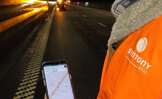
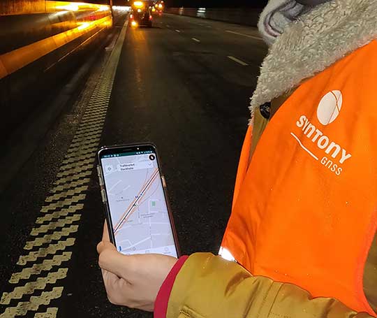
A Syntony team member in a Swedish road tunnel during SubWAVE testing shows the positioning in an underground environment on a smartphone. (Photo: Syntony GNSS)
By emitting a perfect emulation of the “real” GNSS signal, SubWAVE offers underground operators, their staff, emergency services and the general public the benefit of full GNSS coverage in all underground areas for both operational and safety reasons.
One fundamental aspect is the user only needs a standard GNSS receiver (a smartphone or TETRA radio) — no new handsets, receivers or apps are required. The system operates by broadcasting synthetic location specific GNSS signals through existing or new leaky feeder cables in the tunnels.
Accuracy levels vary with leaky feeder and system complexity options; however, 2-meter accuracy is possible with a standard smartphone. The system is widely installed in the Stockholm metro and is in active trials throughout Europe and America.
“We are pleased to form a partnership with GNSS specialists Chronos,” said Joel Korsakissok, president of Syntony GNSS. “Their knowledge and experience, together with their dedicated installation, commissioning and support teams complement our sophisticated solutions.”
“Since its first general availability, one of the well-known shortcomings of the GPS system was lack of indoor or underground coverage,” said Charles Curry, managing director with Chronos. “Many have tried to solve this with various technologies over the years. Syntony’s innovative technology offers underground GNSS coverage for PNT applications. We are very excited by the possibilities and pleased to be partnering with them to offer their solution for critical infrastructure applications in the UK.”
In addition, Chronos will also supply Syntony’s sophisticated GNSS simulators used in the aerospace and defence industries for product testing.
Skyports’ delivery drone, manufactured by Wingcopter, takes flight. (Photo: Wingcopter)
Skyports and Thales are partnering to conduct a drone delivery trial for the National Health Service (NHS) to support the United Kingdom’s COVID-19 response.
The trial, being conducted in Scotland, aims to prove the feasibility of delivering urgent medical cargo, such as COVID-19 test kits and Personal Protective Equipment (PPE), between remote medical facilities by delivery drone. The trial is backed by Argyll and Bute Health and Social Care Partnership (HSCP) — the integrated partnership of NHS Highland and Argyll and Bute Council directed by the local Integration Joint Board.
U.K. drone delivery provider Skyports will conduct the trial and operate the flights using delivery drones supplied by unmanned aircraft-maker Wingcopter, because of its proven capability through numerous delivery operations around the world. The trial flights will be planned through Thales’ drone operations management platform, SOARIZON, which offers digital tools to maintain compliant and safe drone flying operations.
Based at Lorn and Islands Hospital in Oban, the trial will consist of two-way flights between the hospital and Mull and Iona Community Hospital in Craignure 10 miles (16km) away on the Isle of Mull.
As COVID-19 testing rapidly gathers pace in the U.K., the proposed delivery service will help to ensure that isolated communities have access to tests, delivered in a fast and efficient way. Currently, the majority of medical supplies and specimens are transported between the laboratory at Lorn and Islands Hospital, surrounding general practitioners’ surgeries and other healthcare settings by sea and road, a long and complicated journey.
The service would cut delivery times from up to six hours one way by ground transport and ferry, to 15 minutes for on-demand delivery by drone. The speed would contribute to keeping front line medical and delivery personnel safe.
Answering the call from government and Argyll and Bute HSCP, in response to the COVID-19 crisis, the trial is the result of rapid mobilization from industry as well as the Civil Aviation Authority (CAA), local government, NHS Scotland and the U.K. Department for Transport (DFT). Argyll and Bute HSCP has been at the forefront of exploring with Skyports the use of unmanned aircraft technology, building on preliminary work with the Scottish government on the possibility of drone use by the public-sector emergency services in Scotland.
The two-week trial represents a crucial milestone for unmanned aviation in the U.K. Under current rules, drones must always be flown within visual line of sight of the remote pilot. To undertake these more extended flights (beyond visual line of sight, or BVLOS), the project team has been in close consultation with the CAA.
Through this trial, the alliance aims to prove the long-term, sustainable viability of such services; bringing together regulation, government and industry to unlock the transformational potential of drones for society when used in a safe, secure and controlled way.f this new service.”
Thales and Skyports are also working together within the CAA Regulatory Sandbox programme, exploring how regulatory approvals can be granted for more widespread BVLOS drone operations in the U.K.
Once the trial has been successfully completed, the team will continue to work closely with the CAA and the NHS to make services available in Scotland and across the U.K. to provide access to this innovative technology to a wide range of organisations, in particular a number of other NHS Boards and Trusts.
Cobham make the anti-jam GPS for the Lynx Wildcat. (Photo: U.K. Ministry of Defense)
Research contract to protect satellite signals from interference
Cobham Aerospace Connectivity will research advanced GNSS anti-jam techniques for the United Kingdom Ministry of Defense (UK-MOD). The research contract was awarded by the Ministry of Defense’s Defence Equipment and Support (DE&S) office.
Under the contract, Cobham will develop means to provide assured and resilient position navigation and timing (PNT) information derived from GNSS. The company has extensive background in advanced antenna technology and sophisticated signal-processing capabilities.
Cobham makes the conformal GPS CRPA for the Eurofighter Typhoon. (Photo: Cobham)
The research is set against a backdrop of increasing reliance on GNSS navigation signals in the nation’s critical infrastructure and national security and the frequent interruptions of the signals either accidentally or intentionally. The more sophisticated interruptions involve the falsification of the navigation signal information for nefarious reasons such as piracy, civil disruption and military advantage.
Cobham’s goal is to take already-developed anti-jam capability and develop a miniaturized system that can provide an advanced means of protection of the navigation signals received from the GNSS multi-constellation network.
Cobham beam-forming anti-jam GNSS digital antenna control unit. (Photo: Cobham)
The anti-jam system will combine the use of advanced controlled radiation pattern array (CRPA) antenna technology with intelligent digital signal-processing techniques. It will be designed to ensure reliable and assured navigation information, as well as derive important signal intelligence and domain-awareness information regarding the source and nature of the interference and the best means of mitigation.
“This contract award recognises Cobham’s status as a major UK provider of anti-jam systems as well as our long history and deep experience in the areas of navigation antennas and satellite connectivity,” said Neil Tomlinson, vice president of Sales and Business Development at Cobham. “We look forward to working with DE&S in this initial phase and subsequent work on this exciting project.”
The UK’s emergency service responders and other critical services could be set for more resilient time systems through the National Timing Centre.
The United Kingdom has established a new timing center to reduce reliance of public services and its economy on GNSS satellites. The center uses a network of atomic clocks housed at secure locations, and consists of a team of researchers based at sites across the U.K.
The National Timing Centre will provide additional resilience for accurate timing, which underpins many everyday technologies including emergency response systems, 4G/5G mobile networks, communication and broadcast systems, transport, the stock exchange and the energy grid — all of which depend on precision timing from GNSS.
A large-scale GPS failure would cause a £1 billion a day economic impact to the UK. Loss of this accurate data would also have severe and life-threatening effects, such as on getting ambulances to patients or getting power to homes around the country. The center’s land-based technologies will improve the UK’s resilience and provide important back-up.
The UK’s current dependence on satellite technologies has been identified by the government as a potential security risk if a satellite were to experience a failure. The Blackett Review in 2018 looked at the UK’s vulnerabilities to over-reliance on Global Navigation Satellite Systems (GNSS).
The government is investing £36 million to create the National Timing Centre, which will ensure the UK economy and public services have additional resilience to the risk of satellite failure. The investment will build a resilient network of clocks across the UK. It includes £6.7 million which will be made available via Innovate UK funding calls to SMEs and industry to innovate around timing and clocks.
Science Minister Amanda Solloway announced the center on Feb. 19. “Our economy relies on satellites for accurate timing,” she said. “Without satellites sending us timing signals, everything from the clocks and maps on our phones, to our emergency services and energy grid would be at risk. I’m delighted that this world-first centre will see our brightest minds, from Surrey to Strathclyde, working together to reduce the risks from satellite failure.”
“The failure of these systems has been identified as a major risk, and The National Timing Centre programme will help to protect both vital services and the economy from the disruption this would cause while delivering considerable economic benefits,” said UK Research and Innovation Chief Executive Professor Sir Mark Walport.
“We are proud to be leading the way in providing trusted and assured time and frequency,” said National Physical Laboratory CEO Pete Thompson. “The work undertaken by the team here has ensure the National Timing Centre programme will provide huge benefits to society, whilst underpinning secure applications in the future.”
The center also includes researchers at the University of Birmingham, the University of Strathclyde, University of Surrey, BT Adastral Park, Suffolk, BBC, Manchester, and the National Physical Laboratory in Teddington.
The £76 million investment furthers the government’s commitment to significantly boost R&D investment across every part of the UK, including funding transformational technologies and increasing the number of researchers.
The funding is provided through the Strategic Priorities Fund, which supports high-quality discipline research and development priorities, with investment also going towards autonomous systems and national collections.
Highly accurate, UK city-wide 3D models are now available to view and download from Bluesky’s online Mapshop.
The geographically accurate, photo-realistic MetroVista mesh models are available in a variety of formats ready for use in 3D GIS, CAD and other modelling software as well as visualisation, gaming and Virtual Reality workflows.
Captured using Leica’s large-format imagery and lidar hybrid airborne sensor and generated in Skyline’s PhotoMesh software, the Bluesky MetroVista datasets of major UK cities are available online offering a compelling alternative to traditional photogrammetrically produced models.
Now in America. In December, Bluesky launched its 3D data capture programme in the United States. The MetroVista product suite allows high-resolution imagery, both vertical and oblique, to be captured simultaneously with high-accuracy, wide-scale 3D data using an advanced Leica camera, the CityMapper. Specifically designed for 3D city modeling and urban mapping, the system includes a traditional vertical camera as well as survey-grade oblique cameras.
The CityMapper also includes high-performance lidar technology to accurately collect elevation data — even in shadows that are common in urban environments and can make photo-based collection difficult.
“Since launching in the UK the MetroVista product range has received enormous offline interest from sectors such as infrastructure and building development, risk assessment, telecommunications and environmental mapping,” said Rachel Tidmarsh, managing director of Bluesky. “By making the data easy to access and consume via our online Mapshop, we hope to increase the take up from traditional users of 3D models and encourage applications such as smart city management, autonomous vehicle testing, virtual reality experiences and gaming.”
Two seasons in the UK
Bluesky has been capturing MetroVista data in the UK for two flying seasons. Visitors to Bluesky’s Mapshop will initially be able to select an area and download MetroVista mesh models of London, Birmingham and Cambridge with other UK and U.S. cities coming online in the future.
Data can be supplied in a variety of proprietary and open source formats including OBJ, FBX, I3s and 3DML for use in Skyline’s TerraExplorer product suite.
The Bluesky Mapshop also offers complete nationwide coverage of aerial photography from multiple epochs, 3D models, lidar data, thermal mapping and Bluesky’s National Tree Map. Blueskymapshop.com is easy to use and purchasing of data is simple, straightforward and secure. Account options are also available and data can be purchased with a range of easy to understand licence options, including the option of a Sub Contractor Licence.