A new post-Brexit GNSS “must be secured,” according to the UKspace trade association. On Nov. 21, UKspace published its manifesto for a future British government to consider, which includes actions that will enable Britain to compete in the “new space race.”
Among the recommendations is a satellite system to provide navigation services.
“The UK’s post-Brexit participation in a new global satellite navigation system must be secured, whether through ESA or a sovereign capability,” the manifesto said.
“The 2019 Spending Review committed to continuing to provide £191M of funding to support Brexit-related activities ‘including the development of a UK Global Navigation Satellite System option and delivering business stability for company law and audit.’
“Following this initial design phase, the estimated cost of the programme is £5B. This needs to be reflected in long-term budget lines to sustain key precision, navigation and timing skills in the industry.”
Other topics in the manifesto include increased funding for the European Space Agency (ESA), establishment of a national space program, continuing to partner on Copernicus, and funding for the new National Space Council.
With Brexit on the horizon, the U.K. Space Agency is interested in creating its own GNSS.
The agency is investing in research and development that explores challenges and ideas around receivers for a future UK global navigation satellite system.
Specifically, the agency is seeking UK organizations that are interested in investigating and developing concepts for satellite system receivers.
Following Brexit, the UK would be locked out from the European Union’s Galileo-provided services, including the upcoming Public Regulated Service (PRS), an encrypted navigation signal for governmental-authorized users and sensitive applications such as the military.
A committee of the U.K.’s House of Commons issued a report calling for greater drone regulations, including registration, drone ID transmission and geofencing around sensitive locations.
In its summary, it recalls drone sightings at Gatwick Airport in December 2018, which caused “significant disruption and highlighted the need for further recognition of the substantial rise in the purchase and use of commercial and civilian drones more widely.”
Restricted Airspace
The report calls for more studies, such as on airport/drone collisions. It recommends that the government complete an assessment of the risks that drones pose to manned commercial aircraft and publish the findings by the end of 2020.
“The committee is concerned that there is no agreed position on the likely consequences of a drone-airplane impact,” the report says.
The committee also recommends temporary drone flight restriction zones around helicopter landing zones and said the government should consider geo-fencing as a compulsory measure around prisons and high security areas.
“We recognise the importance of extending Flight Restriction Zones to five kilometres. However, these restriction zones are not clearly or consistently enforced,” the report states. “The lack of a standardised process results in inconsistent denials and permissions being granted to those applying. This is unacceptable.”
“The government should commission the production of a standardised and unified system through which drone operators can request access to Flight Restriction Zones. This could be achieved by working with National Air Traffic Services on its development of an Airspace User’s Portal. This should be completed no later than summer 2020.”
Drone Registration
The report recommends that the government begin a UAV registration system, enabling identification of lawful drone operators. Those registering would also have to pass a knowledge test. It also recommends that drones be “electronically conspicuous” with some form of electronic ID within two years. Both ID and geofencing should be standard in drones, the report said, with penalties for disabling these features.
If a drone user doesn’t register, “We recommend a sliding scale of penalties for failure to register, starting with a warning, and culminating in a fine and a prison sentence,” the report states.
BVLOS and UTM tech testing
A beyond-visual-line-of-sight (BVLOS) testing facility should be established so that unmanned traffic management (UTM) systems and related technologies can be tested, the report recommends.”Clear plans should be set out for this as soon as possible and further testing should begin no later than Summer 2020.”
The report concludes, “The government should produce a white paper by summer 2020 that outlines the vision for how drones will be integrated into UK communities over the coming years.”
QinetiQ and its partner Collins Aerospace have won a £67 million contract with the United Kingdom’s Ministry of Defence (MOD) Defence Equipment and Support (DE&S) to develop multi-constellation satellite receivers under the U.K. Robust Global Navigation System (R-GNS) program.
The program will deliver critical capability to provide UK Defence with accurate and resilient positioning, navigation and timing (PNT), which will underpin the UK’s ability to undertake 24/7 military operations around the world in demanding and increasingly contested operational environments.
QinetiQ, working with its partner (Collins Aerospace) and sub-contractors (Roke Manor Research, Raytheon Systems Limited, Garfield Microelectronics, Nottingham Scientific Limited, Phixos and a number of other specialist suppliers and manufacturing partners) will work together to provide advanced navigation products that are UK sovereign supplied, low size, weight and power (SWAP) delivering high-accuracy, resilient and secured operational capability.
The use of multi-constellation, multi-service satellite navigation signals, multiple sensors and QinetiQ’s advanced processing technologies will enable secured navigation, ensuring that users and platforms —autonomous land, maritime, air and weapons systems — will be able to navigate accurately, robustly and safely.
“Whether it’s soldiers conducting operations in remote environments or fighter jet pilots flying in contested airspace, our Armed Forces depend on satellite navigation technology,” said Defence Minister Anne-Marie Trevelyan. “These state-of-the-art receivers will help to ensure our armed forces can defend UK interests wherever and whenever they are threatened.”
“Ensuring that UK Forces have the best and most resilient secured navigation capabilities is essential to ensuring that they are able to operate effectively in increasingly challenging operational environments,” Steve Wadey, CEO, QinetiQ said. “We are extremely pleased to be working with MOD, DE&S and DSTL to deliver this critical capability. This programme will exploit QinetiQ’s advanced technologies and, working collaboratively with our partners across the supply base, deliver substantial operational advantage for UK Defence.”
The delivery date for the first R-GNS products is February 2022.
CityMapper is a hybrid airborne sensor combining vertical and oblique imagery with 3D laser scanning designed for 3D city modeling and urban mapping.
Using the CityMapper, Bluesky was able to capture parts of London, Manchester and Birmingham as well as Brighton, Bristol, Cambridge, Norwich, Nottingham and Oxford. Bluesky intends to increase its coverage by capturing additional towns and cities across the U.K. and Ireland in 2019.
St. Paul’s Cathedral in London captured in lidar point-cloud data. (Image: Bluesky)
According to Bluesky, this is the first time the technology has been used commercially in the UK to this level. The captured city data is available from Bluesky and Leica Geosystems, part of Hexagon, in its constituent components of vertical orthorectified aerial imagery, oblique photographs and lidar point cloud data. Plans are in place to also include the imagery in the HxGN Content Program.
The combination of multiple survey-grade cameras and lidar enables the simultaneous capture of data for the automatic creation of highly accurate and detailed citywide 3D models, with one sensor, according to Bluesky.
Previous 3D models have either been prohibitively expensive for use across larger areas or of insufficient detail or accuracy. The CityMapper sensor enabled efficient, cost-effective capture of highly detailed and accurate data, and could make possible widespread use of 3D models possible.
The CityMapper sensor is designed for 3D city modeling and urban mapping. (Photo: Leica Geosystems)
CityMapper includes a traditional vertical camera as well as survey-grade oblique cameras. The sensor also includes high-performance lidar technology to accurately collect elevation data even into the shadows, which are common in urban environments and make photo-based data collection difficult.
The CityMapper sensor also collects color infrared data, which can be used to aid greenspace mapping and vegetation studies.
Applications of the new Bluesky 3D models are expected to include urban planning, line-of-sight analysis, new development visualizations and environmental modeling, as well as potentially 3D fly throughs and virtual reality experiences. Early adopters of the data include architects, planning consultants and other map publishers.
The International Navigation Conference, sponsored by the Royal Institute of Navigation (RIN), is a premier forum for the presentation of research and advances in navigation.
The 2018 conference — the RIN’s fourth — will take place Nov. 12-15 in Bristol, England, United Kingdom.
INC2018 brings together industry, academia and governments from around the world. The theme for INC2018 is “Navigation Challenges and Societal Benefits.”
The United Kingdom and the European Union (EU) continue locked in conflict over Galileo post-Brexit, much akin to a divorce dispute over the children.
The European Commission has initiated proceedings to exclude the U.K. and its companies from security work on Galileo before the country’s exit from the bloc next year, a move that presages exclusion from use of the security features of the Galileo PRS signal.
The U.K. has responded with a demand for repayment of up to 1 billion pounds ($1.34 billion).
Both sides say they wish to continue working together on the GNSS, but the EU insists that it must be under new rules, including those preventing third countries from obtaining access to critical security information. The European Commission, executive arm of the EU, says the U.K. can no longer be trusted with sensitive data providing a secure back-up for the new satellite system.
“It’s simple: Britain is part of Galileo today as an EU member, but won’t be automatically part of Galileo tomorrow as a third-party state,” said an EU advisor. “That’s the mechanical, legal consequence of Brexit.”
The U.K. for its part has made unrestricted access a condition for a broader security collaboration.
There has been speculation that the U.K. would use the $1.34 billion alimony settlement to build a new GNSS, drawing on expertise from Australia — in effect, engendering offspring from a new marriage.
Westfield Technology Group, a British vehicle manufacturer, and Ordnance Survey have signed a Memorandum of Understanding (MoU) to support autonomous vehicle development.
The MoU will support a wider range of autonomous vehicle operations by improving access to detailed and accurate mapping.
Project LAVIS is investigating how autonomous vehicles, particularly shared PODs, could offer residents and visitors sustainable and shared transport around the Lake District National Park area.
Previous collaborations between Westfield Technology Group and Ordnance Survey include jointly collaborating with Emirates Airlines in Dubai and mapping potential autonomous vehicle routes in the Lake District for the Innovate U.K.-funded Project LAVIS.
Recognizing the mutual benefits of collaborating on domestic and international activities, the organizations will continue developing and advancing autonomous vehicle capability. By utilizing 3D high-definition mapping capability, this partnership will add significant value the autonomous vehicle industry, the companies said.
“We’re very excited about strengthening our working relationship with Ordnance Survey,” said Julian Turner, CEO at Westfield Technology Group. “This MoU will allow us to further advance and improve our autonomous vehicle operations, particularly in areas which desperately need access to sustainable, reliable and flexible transport.”
“This MoU further cements our relationship with Westfield Technology Group,” said Andy Wilson, region director for Europe and Africa at Ordnance Survey. “We’re excited about collaborating on this important project, which is another example of how accurate, up-to-date geospatial data and mapping is key to the success of new and emerging technologies.”
On April 26, the U.S. Department of Transportation publicly released the long-awaited GPS Adjacent Band Compatibility Assessment. See the June issue of GPS World for an expert and measured analysis of this highly impactful document.
The article will be posted online when it becomes available in mid-to-late May.
Merger Mystery
Contrary to the “Out in Front” editorial published in the April issue of GPS World magazine, there was an Izvestia story published on March 28 touting a merger of the GLONASS and BeiDou systems, and there will be an International Conference on Advanced Technologies in Manufacturing and Materials Engineering in Harbin, China, at which such a possibility may hypothetically be discussed.
However, neither hard news nor any official statements have emerged to substantiate such a dubious claim, despite repeated queries to officials of both countries.
Javad Ashjaee (far left, above), CEO of JAVAD GNSS and based in Moscow, communicated that he spoke on a panel at an aerospace technology event organized by the American Chamber of Commerce in Russia, alongside representatives from NASA, Boeing, Honeywell and Roskosmos.
Ashjaee asked the Roskosmos official publicly about the prospect of a GLONASS merger with BeiDou, and “he knew nothing.”
Diverger Dilemma
As this magazine goes to press, stories emerge of a U.K. plan to launch a satellite-navigation system separate from the European Union’s Galileo project. This comes in response to an EU statement that the UK would be shut out of key elements of the European satnav program, particularly the Public Regulated Service, after Brexit.
Historically, in the late 1980s or early 90s the UK drew up plans for its own GNSS prior to the launch of Galileo. And UK-based Surrey Satellite Technology Ltd. built all operational Galileo payloads to date. So the country clearly has the capability. That SSTL is currently owned by Airbus (either German or Dutch division) may or may not constitute a wrinkle.
Finally, the UK spent 1.4 billion euros on Galileo, and may now file for a refund.
The Long Life of GPS III
By Robin Wrinn, Contributing Author
GPS III SV01 in electromagnetic interference, compatibility and passive intermodulation testing. (Photo: Lockheed Martin)
During interviews with Lockheed Martin and Harris Corporation at the 34th Space Symposium, time and space were a frequent focus of discussion, but not in the normal “continuum” kind of way.
Greater mission longevity is one of the key improvements GPS III delivers over those currently in service. Space Vehicles 1–10 have a planned mission life of about 15 years, 25 percent longer than their predecessors. Yet that begs the question “How long should a satellite live in space, with technology innovation occurring almost annually?”
Advanced payload technology provides a partial answer to that question. Both Lockheed Martin and Harris Corporation highlighted new payload capabilities with built-in flexibility to adapt satellites in orbit to technology advances, as well as changes in missions.
Lockheed Martin provided the media a tour of their Radio Frequency Payload Center of Excellence. Meanwhile, Harris recently announced completion of the fully digital Mission Data Unit (MDU), core to the navigation payload for GPS III 11 +. As a reminder, the current Harris payload for SVs 1–10 includes:
greater than three times reduction in range error,
up to eight times increase in anti-jamming power,
added signals, including L1C, compatible with other GNSS such as Galileo, and
greater signal integrity.
According to Harris, the fully digital navigation payload will provide the ability to change and upgrade the satellites incrementally over mission life.
Meanwhile, Lockheed announced a partnership with NEC to introduce artificial intelligence for computer learning in orbit. The company’s Payload Center experts touted significant advances in processers and a move toward next-generation antennas, arrays and transmitters to drive more satellite flexibility, capability and resilience.
Observation: The market pressures of ‘new space’ players is prompting delivery of products that can drive more value for less cost. In this case, delivery of a common payload architecture and electronically steered beams to make satellite antennas become any shape you want. Most likely, beams of a different size on demand is a much better business case than a static one built five years ago.
The day I interviewed Lockheed Martin’s Navigation Systems mission area Program Manager Johnathon Caldwell, the company had submitted its proposal for the U.S. Air Force’s GPS III Follow On (GPS IIIF) program. That same day, April 16, the media was given a tour of Lockheed Martin’s GPS III satellite assembly floor. It was clear from both Lockheed’s press materials and Caldwell that Lockheed Martin believes it is fully recovered from prior production hiccups and is
on track to deliver GPS Space Vehicles (SVs) 1 through 10, and
deserves to win the bid for GPS IIIF. Now that both Boeing and Northrop Grumman have dropped out of the running, Lockheed is virtually assured the contract. The government has said it will announce the award in March 2019.
What are the differences in the GPS III satellite payloads that were instituted to enable the new signals?
The main difference is the power. The Air Force’s requirements called for significantly more anti-jamming capability. All the transmitters are a higher power.
What was the most significant obstacle (or top obstacles, plural) in designing and manufacturing this new payload, to new Air Force specifications? How did you overcome it/them?
Same answer really, the higher power. Keeping in mind, we went from a 7-year mission life requirement to a 15 year. That higher power puts more strain on components and new cyber requirements in software. When you couple all that together we are not just upgrading payload technology. It is really engineering a new set of payload requirements. It’s new generation, advanced.
What are the advantages of a digital payload over the alternative?
The advantages and the 30 percent difference are the timekeeping system portion. We’re moving from a manual, analog timing to digital to deliver to the Air Force more flexibility. It’s a nice option to have to be able to reprogram in orbit and maybe enhance capabilities desired in the future.
with Johnathon Caldwell, Navigation Systems Mission Area Program Manager
Any changes in your production approach having completed SV01?
No, the performance on Vehicle 01 was as designed there were no technical or design changes necessitated throughout the rest of the fleet. So, it was a very successful from that perspective — from the standpoint of validating the design and wringing it out, Vehicle 01 served its purpose well.
It had a very good T-Vac. I would say overall when you look at the industry, Vehicles 01–02, our vacuum test campaigns are the most rigorous test. Both went through their tests quite well. Some of the best I’ve seen.
A U.K. government report issued on Jan. 30 looks at the vulnerability of all satellite-based positioning systems: GPS, Galileo, GLONASS, BeiDou, QZSS and more. Issued by the Office of the Government Chief Scientific Adviser, Sir Mark Walport, and informally called the Blackett Report, designating the highest level of government scientific studies, named after a UK physicist who won the 1948 Nobel Prize, the review aims to “lay out the breadth, scale and implications of our reliance on ‘the invisible utility’ mainly in terms of existing critical national infrastructure (CNI).”
“Satellite-derived Time and Position: A Study of Critical Dependencies” states in the forward that it “represents a vital step in understanding the UK’s dependency on GNSS and recommends measures to improve our resilience. Importantly, it also recognises that innovation will be key to realising, fully and safely, the economic and societal benefits offered by GNSS.”
The report points to the fragility of satellite positioning signals which can be affected by cheap jammers, spoofers, weather and interference from other radio signals — among other vulnerabilities. The 86-page PDF document is downloadable here.
The review incorporates the results of a separate but related study, issued in April 2017, looking at the fiscal consequences of a GNSS disruption in. “Economic Impact to the U.K. of a Disruption in GNSS” was briefly summarized in a June 2017 column from this magazine (scroll down to “At What Cost Ignorance?”). The report attempted to quantify the cost of a GNSS disruption, should one occur. The authors came up a figure of 5.2 billion pounds ($6 billion) for a 5-day disruption.
David Last, a UK consultant engineer specializing in radio navigation and communications systems, professor emeritus at the University of Bangor, Wales and past president of the Royal Institute of Navigation, consulted on the June 2017 economic impact report, and was a member of the expert panel and co-author of the January 2018 Blackett Report. He was to have given a presentation on them at the ION International Technical Meeting in Reston, Virginia on January, but could not make the trip. The following materials are drawn from his prepared presentation.
Some of the conclusions from the June 2017 economic impact study are:
There are alternatives to GNSS, specific to each application
However, there is no universally-applicable single alternative for positioning and navigation
Among the most salient needs: higher quality (more expensive) oscillators for timing
“The most applicable mitigation strategies for the largest number of applications are eLoran and Satelles.”
“Omnisense and Locata may be preferred for localised applications that require high levels of accuracy.”
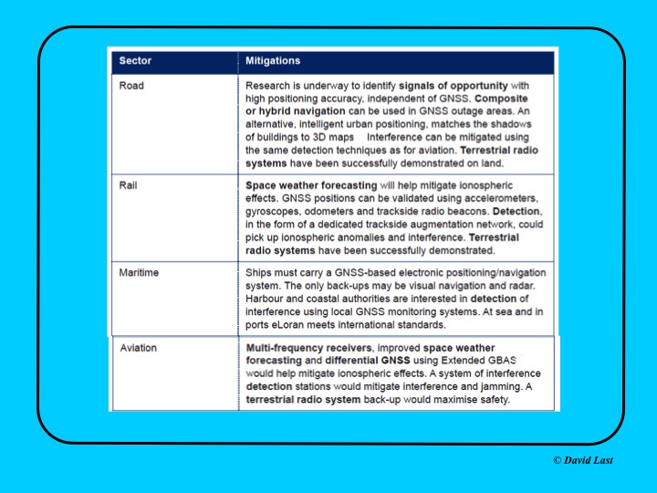
From the just-issued Blackett Report, the first figure displayed above presents recommended mitigations to impacts on GNSS applications in road, rail, maritime and aviation. Alternative options include composite or hybrid navigation, terrestrial radio systems, space weather forecasting, eLoran, various methods of interference detection, multi-frequency receivers and differential GNSS.
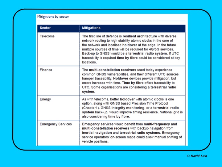
A second figure from Last’s presentation, shown above, covers the mitigations recommended for telecoms, finance, energy, and emergency services sectors. Mitigations for these applications include a resilient architecture with diverse network routing to high-stability atomic clocks, terrestrial radio systems, time-by-fiberoptics, multiconstellation receivers, holdover devices, GNSS integrity monitoring, and inertial navigation.
Concluding recommendations of the Blackett Report:
CNI operators to review and report on their reliance on GNSS. Cabinet Office to assess overall dependence of CNI on GNSS.
Add loss or compromise of GNSS-derived PNT to National Risk Assessment, not just as a dimension of space weather.
In allocating radio spectrum to new services and applications, address the risk of interference to GNSS-dependent users, including CNI.
Review the legality of the sale, ownership and use of devices and software to cause deliberate interference to GNSS receivers or signals.
Assess the need to monitor interference of GNSS at key sites such as ports and share the data with government
Employ GNSS-independent back-up systems.
Cross-government PNT Working Group to report to Cabinet Office on ways to improve national resilience.
Government to facilitate as those procuring GNSS equipment for CNI specify performance standards.
Map PNT testing facilities and explore how industry and critical services can better access them.
Leverage UK academic and industrial expertise in time and geo-location, increasing coordination among existing centres of excellence.
Participation of the United Kingdom space industry in Galileo may be in doubt as negotiations get underway on details of the U.K. withdrawal from the European Union (EU).
European Commission officials signaled that they want to rely solely on producers within the European Union for the block’s major programs, citing security concerns such as the possible acquisition of a U.K. contractor by a company from a non-EU country such as China.
In particular, officials are concerned about protecting the heavily encrypted, jam-resistant Public Regulated Service capability designed for government use that is reserved for EU member states and where U.K. industry has had a significant role.
Surrey Satellite Technology Ltd., based in Guildford, England, but a subsidiary of France-based Airbus, built 22 navigation payloads for Europe’s Galileo satellite fleet.
Other companies with U.K. interests that could be affected include Qinetiq, CGI, Airbus and Scisys.
Galileo SAR Service Launched
Galileo’s Search And Rescue (SAR) service became officially operational with a public launch on April 6, as part of the COSPAS-SARSAT network for detecting and locating emergency beacons activated by aircraft, ships and hikers. According to the European Commission, Galileo SAR will help reduce the detection delay of a distress signal from up to several hours to 10 minutes.
At sea, this makes SAR rescue operations easier thanks to a narrowed search box, since the vessel in distress has less time to drift. On land, acquisition of a precise position enables rescue teams to more quickly reach the operation zone and assist the victims. In the air, Galileo contributes to fulfilling International Civil Aviation Organization (ICAO) requirements for implementing the next-generation emergency management system Global Aeronautical Distress and Safety System (GADSS).
SAR transponders on Galileo satellites can pick up signals emitted from 406-MHz distress beacons anywhere in the service coverage area and transmit this information to the dedicated ground stations, the Medium-Earth Orbit Local User Terminals (MEOLUTs). The SAR/Galileo infrastructure is interoperable with GPS and GLONASS SAR transponders.
Once the beacon is located by the MEOLUTs, the location data is sent to the COSPAS-SARSAT mission control center, which distributes it to the relevant rescue centers. These then coordinate the required rescue efforts.
Galileo provides a ground segment coverage of 40 million square kilometers over Europe as a contribution to MEOSAR global coverage. Galileo SAR service is one of the three services launched in December 2016 with the Initial Services. The SAR service represented 1 percent of total Galileo program costs, but should result in thousands of lives being saved, said the European Commission.
Pile of Studies Produced Not a Lot
Headshot: Gen. Shelton
Testifying before a joint hearing of the House Homeland Security Committee and House Armed Services strategic forces subcommittee on March 29, Retired Gen. William Shelton, the former head of Air Force Space Command, warned that the U.S. needs to take action to protect GPS very soon.
He cited demonstrated ability by the Chinese government in 2007 to destroy a satellite in orbit, and improved signal jamming and cyber attack capabilities against ground control systems. The U.S. is unprepared to meet those threats, he said.
“Here we are 10 years later and we don’t really have a lot to show but a pile of studies,” Shelton said. “We’ve been part of this ‘one more study’ kind of attitude. ‘Well, that may not be the perfect answer, so let’s just do one more study’ and meanwhile time marches on. Satellites have fixed lifetimes, and you need to plan for the death of the satellite. A decision not to move forward is a de facto decision to maintain the status quo with no protection.”
Shelton stated that space research and development is at a 30-year low, with 15–40 percent of R&D funds taken by management services and technical assistance rather than actual research and development.
“The executive branch and the legislative branch could get together and agree on a strategy and a way forward and then execute … I don’t see any other way. There has to be some broad agreement here in the whole of government as we move forward.”
June Launch in japan for QZSS Michibiki 2
QZSS’s second satellite is scheduled for launch in June. Once completed, the Quasi-Zenith Satellite System will be a satellite augmentation system for GPS over Japan and other parts of the Pacific region.
Michibiki 2 will be launched by the Japan Aerospace Exploration Agency (JAXA), with a launch window planned for June 1–30. The system’s first Michibiki satellite was launched in September 2010.
OCX Back on Track
OCX, the next-generation ground control system for GPS, is back on track following a 2016 government contract breach that prompted the Air Force to work with Raytheon to revise OCX’s budget and schedule, according to the company.
Raytheon implemented a series of corrective actions through 2015 and 2016 to get the delayed program on a firm timeframe for completion. Coding on OCX was about 80 percent complete in late March, according to the company.
Raytheon completed a re-baselining on OCX in March, setting up a new timeline for completion. Current delivery for the full system is planned for December 2020.
DevOps. The OCX team reduced development cycle times to create more efficient software development by using a commercial best practice called DevOps, which adds more automation into coding and testing, and breaks coding down into units rather than focusing on the need to finish the complete system all at once.
A subset of OCX, the Launch and Checkout System for GPS satellites is undergoing testing at Schriever Air Force Base in Colorado. Raytheon expects to complete testing and deliver the system by late September or early October.
EGNOS Refreshes
The geosynchrous Earth-orbit (GEO) satellites broadcasting EGNOS messages changed in March. PRN 123 was introduced in the operational platform, and PRN 136 was moved from the operational platform to the test platform.
Regional aviation in the dense European air traffic system is a key market segment for EGNOS, according to Gian Gherardo Calini, the European GNSS Agency’s head of market development. More than 440 EGNOS-based approaches are available at nearly 220 airports across Europe. These figures are expected to dramatically increase in the coming years.
A proposal from the European Aviation Safety Agency recommends that air ANSPs and aerodrome operators implement Performance Based Navigation (PBN) approach procedures with vertical guidance (APV), such as EGNOS LPVs, at all non-precision instrument runway ends by 2020.
Second GPS III Launch Contracted
The U.S. Air Force has awarded a second GPS III satellite launch contract to SpaceX.
According to the $96.5 million agreement, the company will provide GPS III launch vehicle production, mission integration, launch operations, spaceflight worthiness and mission-unique activities. Work is expected to be complete by April 30, 2019.
An earlier SpaceX launch contract, worth $82.7 million, calls for orbiting a GPS satellite aboard a Falcon 9 rocket in May 2018.
Septentrio, a designer and manufacturer of GNSS solutions, has selected Innovelec as an authorized partner for GNSS positioning solutions in the United Kingdom and Europe. The new partnership will enable Septentrio’s products such as AsteRx-m UAS to meet the needs of unmanned aerial systems (UAS) customers in the European market, the company said.
Based in Hemel Hempstead in Hertfordshire, Innovelec will work directly with Septentrio to offer high-quality strategic services and technical expertise necessary to meet the current and future requirements of GNSS customers in the United Kingdom and UAS customers across Europe to develop new business opportunities in the market.
Since last year, Septentrio has introduced a new set of products that achieve a new benchmark for accuracy and reliably in GNSS solutions. Innovelec will supply the AsteRx product line — renowned for providing consistent and robust centimeter-level positioning under challenging interference and multipath environments.
The AsteRx-m UAS OEM is compact and lightweight module which offers the lowest power consumption on the market at 600 mW. Another product, the AsteRx4, is a robust dual-antenna receiver ready for rapid and straightforward integration into existing workflows or hardware.
“Septentrio’s AsteRx product line offer unbeatable performance, accuracy and reliability in the most challenging conditions,” said Koen Gutscoven, director of Sales at Septentrio. “Innovelec complement Septentrio’s skills to aid further growth in the UK and European market.”
“Septentrio presents an exciting opportunity for Innovelec to further develop its significant business within the GNSS market. Flexibility and support in conjunction with our partners have helped Innovelec to grow and it remains a benchmark of our operations,” said Martin Newman, sales director of Innovelec. “Septentrio bring a lot of expertise of the GNSS market to help us develop new sales opportunities and loyal clients for accurate and reliable positioning across the European market. “