Adtran and Satelles, a provider of secure time and location technology using low-Earth-orbit (LEO) satellites, have partnered to offer operators of critical infrastructure a timing network device with satellite, time and location (STL) technology. The partnership aims to provide an alternative to GNSS by integrating STL technology from Satelles into Adtran’s Oscilloquartz network synchronization products.
Through its partnership with Satelles, Adtran’s Oscilloquartz division will incorporate STL into its end-to-end timing toolkit. The companies will also integrate STL into its grandmaster clocks to develop miniature M.2 form factor STL receiver modules for third-party product integration.
With the ability to deliver precise position, navigation and timing (PNT) service in GNSS-denied applications, STL is suitable for mobile operators, power utility companies, government, scientific research and more. STL technology also offers accurate, secure and augmented Iridium LEO-based PNT services for indoor applications and as backup for GNSS outdoors.
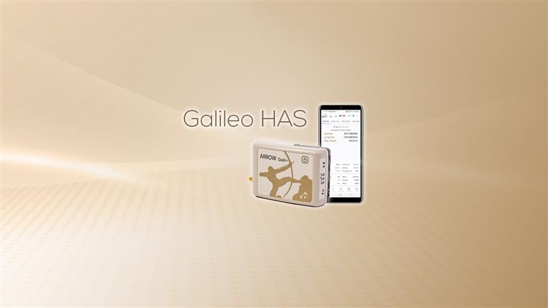
Eos Positioning Systems has released its Arrow Gold+ GNSS receiver, which supports the Galileo high-accuracy service (HAS). Arrow Gold+ enables users to achieve better than 20 cm accuracy with 95% confidence using Galileo HAS.
The Arrow Gold+ is one of the first high-accuracy GNSS receivers that supports Galileo HAS and is designed specifically for the geographic information systems market. Additional signal support for Arrow Gold+ includes: the concurrent use of the BeiDou B3 and GPS L5 signals as well as GLONASS, BeiDou, QZSS and IRNSS signals.
Galileo HAS is a differential correction service from the European Space Agency and European Union Agency for the Space Programme. The service became available on January 24, and it is the first global differential correction service to provide sub-meter accuracy to compatible GNSS receivers anywhere in the world.
For more information on the Arrow Gold+ click here.
Some airlines and military aircraft, including the Australian commercial airline Qantas, are receiving radio interference and GPS jamming from alleged Chinese warships in the Asia Pacific, report Australia Aviation and The Guardian.
The International Federation of Air Line Pilots’ Associations (IFALPA) released a statement acknowledging the reports of interference and recommended that pilots carry on, not respond to the warships and report all incidents to air traffic control.
“IFALPA has been made aware of some airlines and military aircraft being called over 121.50 or 123.45 by military warships in the Pacific region, notably South China Sea, Philippine Sea, East of Indian Ocean. In some cases, the flights were provided vectors to avoid the airspace over the warship. We have reason to believe there may be interferences to GNSS and RADALT as well,” the statement noted.
Further recommendations from IFALPA include notifying company dispatchers of the attempted contact and completing an ASAP report or other company safety report for non-ATC communication or GNSS interference.
GNSS integrity is key to precision agriculture. (Image: fotokostic/iStock/Getty Images Plus/Getty Images)
In the world of global navigation satellite systems (GNSS), there are five key watchwords: accuracy, integrity, availability, continuity and coverage. While all five of those parameters are very important, their priority order depends on the application.
Accuracy: how well a measured or estimated position or time conforms with its true value. If you are a surveyor, accuracy and integrity are your biggest concerns. Accuracy is not to be confused with precision, which is a measure of exactness. It can refer to the number of significant digits reported for a measurement, the rigor of the measuring process, or the agreement among repeated measurements. For example, for locational error a measurement of 9.725m is more precise than 9.7m but may not be a more accurate measure of the error. A measuring instrument is precise if it repeatedly gives similar measurements, regardless of whether these are actually accurate. They could all be off by, say, 5m, due to some bias in the measurement process. In short, precise data may be inaccurate and accurate data may be imprecise.
Integrity: how much the information supplied by the system can be trusted to be correct. This requires the system to provide timely warnings to the user when the equipment is unreliable for navigation purposes—due to obstructions, jamming, multipath or any other event that degrades accuracy.
Availability: the percentage of time that a signal is available to the user. For location-based services, this and coverage are probably the most important parameters.
Continuity: the ability of the total navigation system to continue to perform its function during the intended operation. Continuity is critical whenever reliance on a particular system is high. For a pilot during an instrument approach procedure, continuity and integrity are vital.
Coverage: the area over which a signal is required. For farmers, it is their fields, for ships, the world’s oceans.
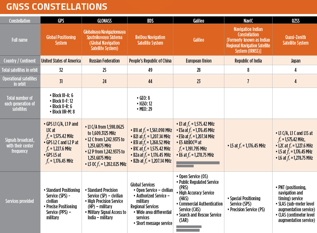
In our October 2021 issue, we celebrated the availability of four global navigation satellite system (GNSS) constellations. Below is the status (as of Feb. 23, 2023) of these four GNSS and their two regional cousins.
Many thanks to Mohamed Tamazin, Ph.D., Senior GNSS Architect for GNSS Simulation with Orolia — a Safran Electronics & Defense company, who provided or confirmed these data. While the data on GPS and Galileo are easily accessible, those for the other constellations are difficult, in some cases very difficult, to find.
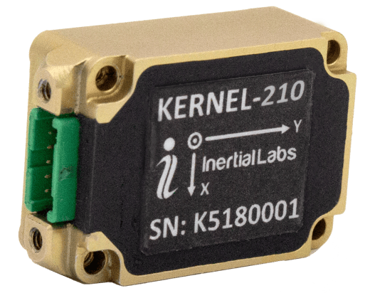
Inertial Labs has released its third generation of MEMS sensor-based inertial measurement units (IMU), MEMS KERNEL-210 and KERNEL-220.
The KERNEL-210 and KERNEL-220 are compact, self-contained, strapdown, tactical-grade IMUs that measure linear accelerations and angular rates using their aligned and calibrated three-axis MEMS accelerometers and three-axis MEMS gyroscopes.
Angular rates and accelerations are determined with low noise and good repeatability for both motionless and dynamic applications.
The KERNEL-220 model utilizes accelerometers with ±40g and ±90g measurement ranges. The IMU is fully calibrated, temperature compensated and mathematically aligned to an orthogonal coordinate system. The KERNEL-220 contains gyroscopes with a bias in-run stability of less than 1 deg/hr and accelerometers with an in-run stability bias of 0.005 mg.
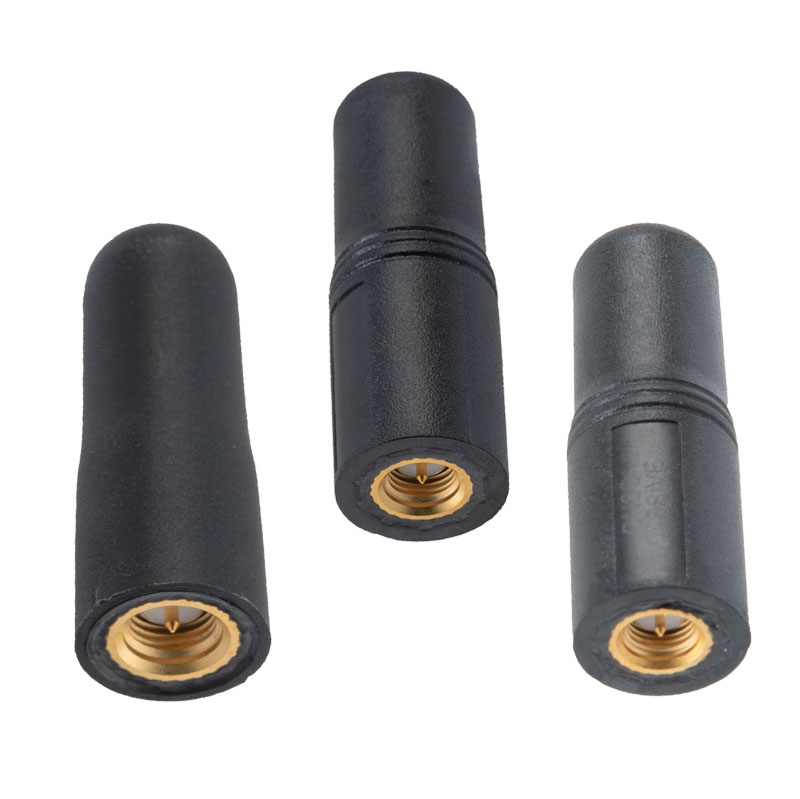
The MIL-STD-810G GPS/GNSS antennas include multi-standard GPS L1, Galileo E1 and GLONASS options and are designed for environmental performance according to the MIL-STD-810G standard.
The antennas are available in passive and active versions and provide coverage from 1,597 MHz to 1,607 MHz. The MIL-STD-810G GPS/GNSS antennas feature linear polarization for cross-polarized isolation, nominal gain options of -3 dBic and 10 dBic, and SMA mounts.
On Feb. 6, a magnitude 7.8 earthquake struck Turkiye and northern Syria creating enormous damage throughout both countries. (Image: mustafaoncul/iStock /Getty Images Plus/Getty Images)
Geographical information of urban areas is critical because it forms the basis for planning, intelligent urban modeling and disaster mapping and management. For many decades, ground surveys and aerial photographs were used as the primary tools for collecting this data. Starting in the 1990s, these methods were replaced by such advanced remote-sensing technologies as synthetic aperture radar (SAR) and ground-based interferometric radar (GBIR).
This article explores the use of software-defined radio (SDR) platforms for acquiring high-resolution SAR/GBIR images, including:
How low-cost commercial-off-the-shelf SDR platforms can be used to realize complex systems for acquiring images and processing measurements.
How different specifications of SDRs make them suitable for use in SAR applications.
Hazard Monitoring in Urban Areas
Many urban areas and critical infrastructure are in regions highly prone to natural disasters such as volcano eruptions, earthquakes, avalanches and landslides, or near man-made systems such as dams and quarries. Monitoring of surface changes and structures is integral to the mitigation of risk and ensuring public safety. Modern remote-monitoring systems allow surface displacements to be monitored without the need to access a location. With these systems, several square kilometers of Earth’s surface can be monitored at once and with high accuracy. The sub-millimeter accuracy of modern remote-monitoring technologies enables accurate measurements to be collected with impressive precision, including in rainy and foggy conditions.
Remote-monitoring systems are autonomous and can operate for a long time without human intervention. Their real-time feedback makes them suitable for use as early-warning systems. In addition, these monitoring systems can be integrated into a wide range of sub-systems, such as decision support systems that assist decision makers in assessing emergency plans and selecting the best options.
Using Radar to Measure
Details of the surface observed by a SAR satellite are encoded in the amplitude and phase of a SAR image. The amplitude component contains information about the surface roughness and terrain slope of the target area, while the phase component contains information about the elevation of the satellite.
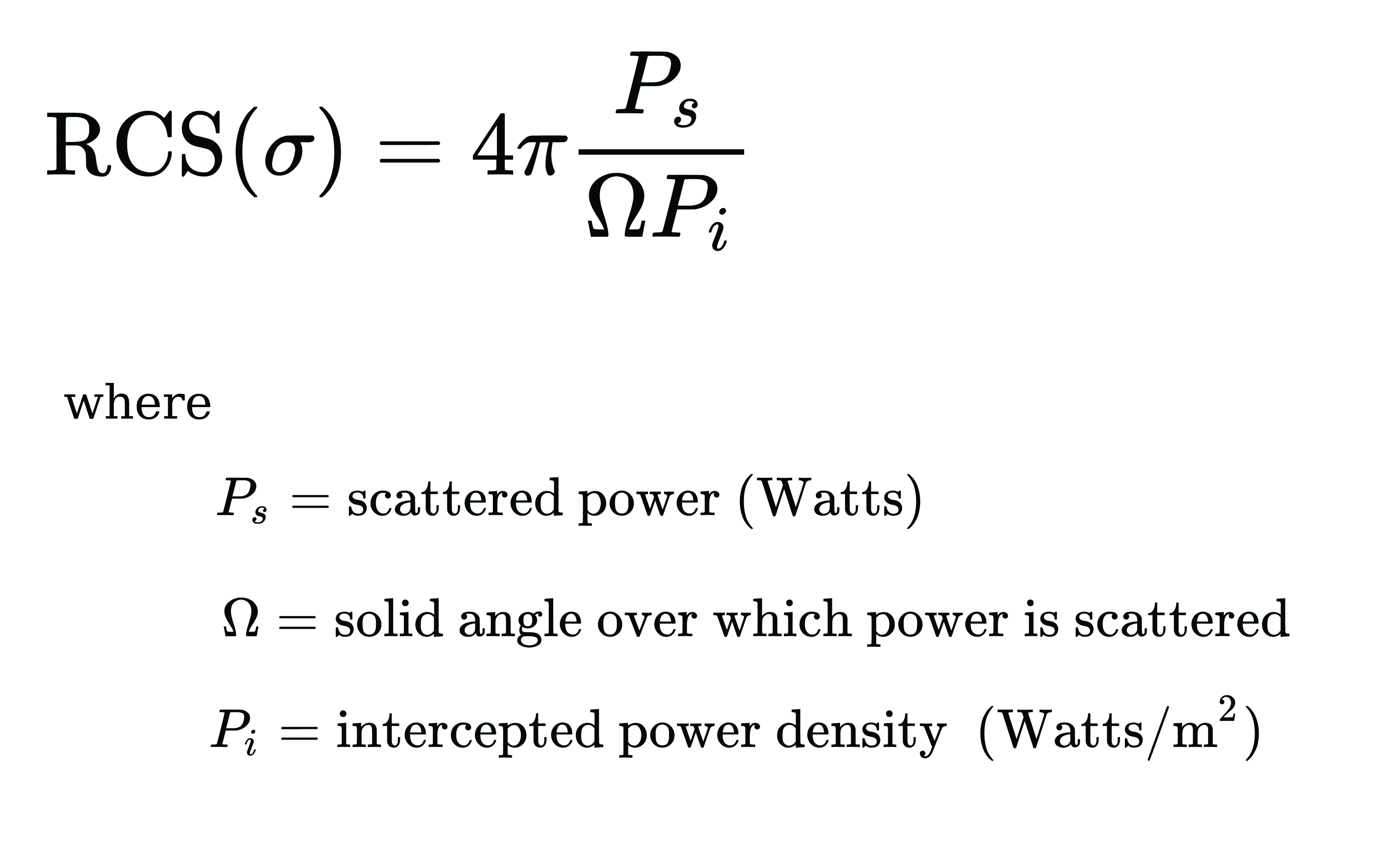
A typical SAR satellite transmits microwave signals toward a target area at an oblique angle and measures the backscattered signal. The intensity of the reflected signal is mainly determined by the roughness and the structure of the target, and the distance between the satellite and the target. This measurement is usually described in terms of the radar cross-section (RCS) parameter, which is obtained by calculating the ratio of the scattered to the intercepted signals as shown in this equation:
The RCS parameter is mainly dependent on the surface roughness and the dielectric properties of the target object.
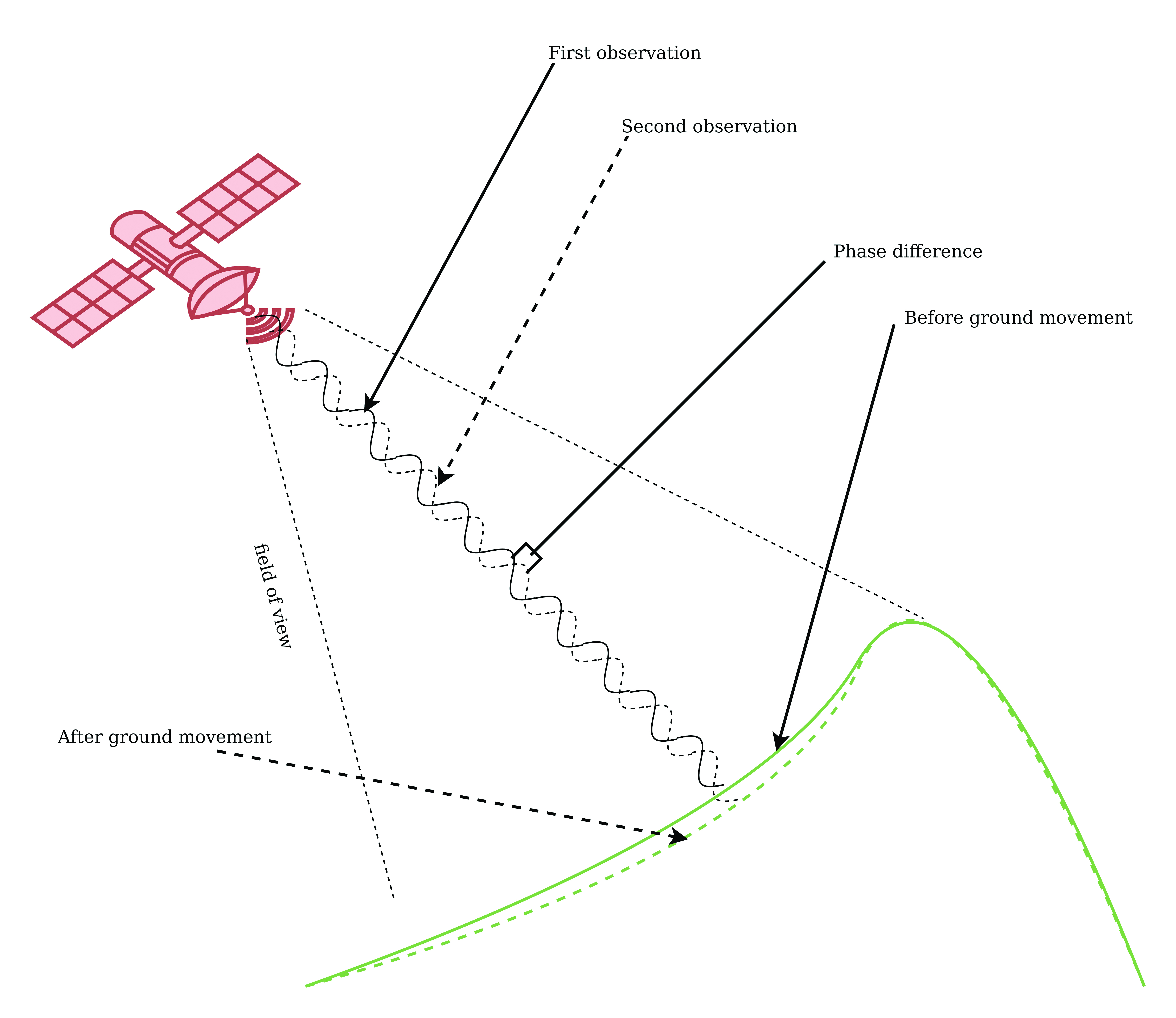
The interferometric SAR (InSAR) technique allows surface movements to be identified. These observations also can be used to measure and monitor changes associated with volcanic eruptions, tectonic activity and other geophysical processes. To identify crustal changes using this geodetic technique, at least two SAR images are required.
Figure 1. Phase shift in InSAR observations due to ground movement. (Image: Simon Ndiritu)
In differential InSAR, two images of the same location that are recorded at different times are used. If a surface movement has occurred between the first and the second acquisition, a phase shift is observed (Figure 1). The presence of interference fringes on an interferogram is an indicator of a phase shift and these fringes are summed during processing to provide a relative value of the phase change.
Ground-based SAR (GBSAR) employs the synthetic aperture radar technique to capture high-resolution images of the electromagnetic reflectivity of a target. This remote-sensing system is commonly used for monitoring civil infrastructure, buildings, mines, landslides, glaciers and more. While spaceborne SAR is capable of surveying large areas and records data over long periods of time, usually several weeks or months, GBSAR is suitable for monitoring small areas and has short sampling periods, usually a few minutes. In most surveying applications, the two remote-monitoring techniques are used together in a complementary fashion to enhance the overall performance.
The all-weather monitoring capability of satellite-based SAR makes it a popular tool for natural disaster management. Since the launch of the first SAR satellite in 1991, this technology has provided many emergency response teams with important insights on manmade and natural hazards. SAR data can be used to study different aspects of long-term behaviors of slow-moving surfaces, which is critical for planning emergency response to natural hazards such as volcanic eruptions, landslides and avalanches. SAR satellites orbit Earth at altitudes of between 500 km and 800 km and operate in the C-band (5 GHz to 6 GHz), X-band (8 GHz to 12 GHz) and L-band (1 GHz to 2 GHz). The temporal resolution of these satellites is mainly determined by their revisit periods.
Software-Defined Radio Platforms
A typical SDR platform features a radio front end (RFE) and a digital back end, with the RFE performing receive (Rx) and transmit (Tx) functions and offering a wide tuning range, typically 0 GHz to 18 GHz. This range is acceptable for widely used bands in SAR applications, including L-band, C-band and X-band.
The digital back end of a high-performance SDR system features a field programmable gate array (FPGA). This FPGA offers a variety of digital signal processing (DSP) capabilities, including upconverting, downconverting, modulation and demodulation. In addition, an SDR platform offers multiple transmit and receive channels, making it suitable for implementing multi-in multi-out (MIMO) radar systems.
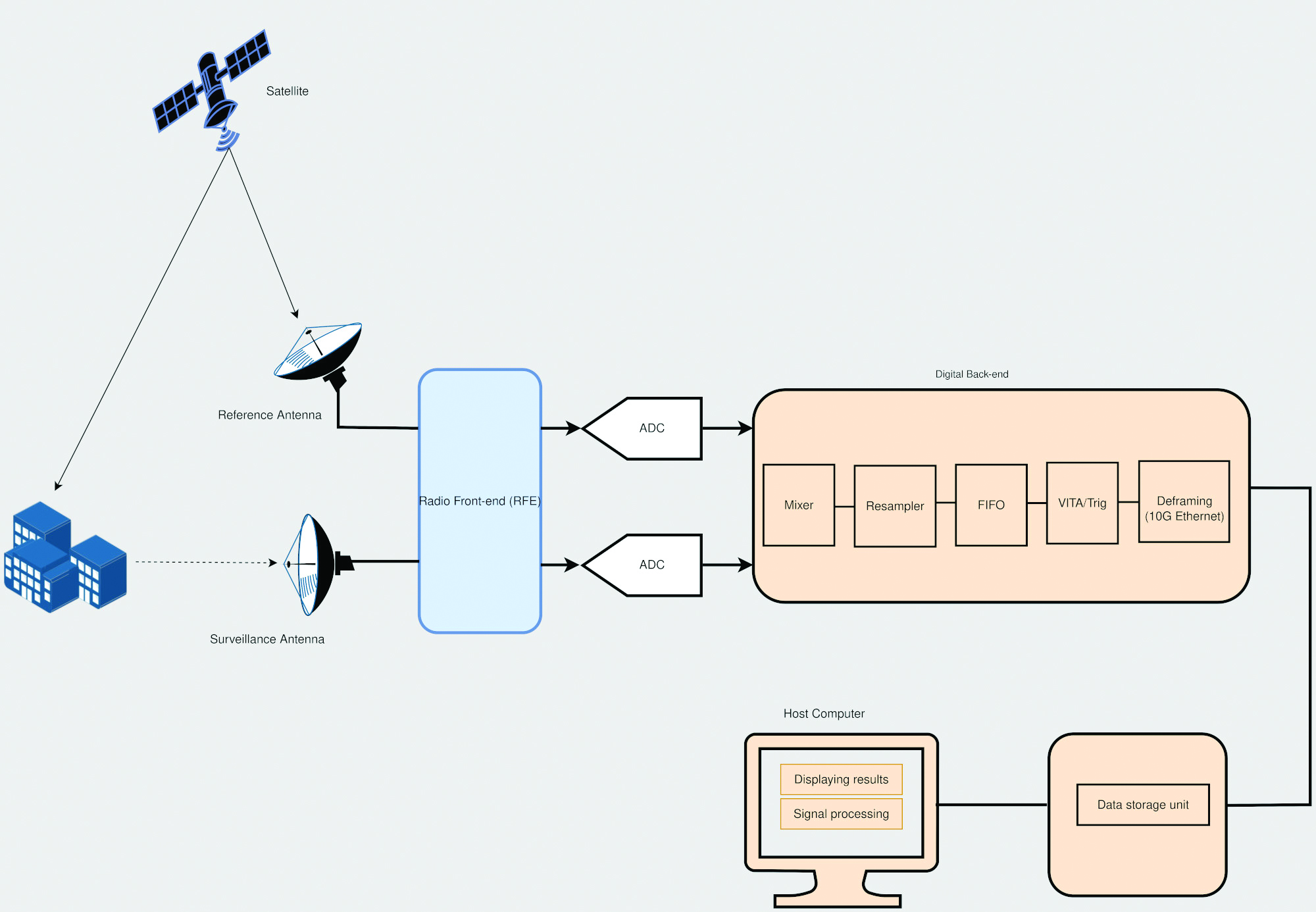
The architecture of SDR platforms allows them to integrate easily with a wide range of complex systems, such as SAR systems. The reconfigurability of SDRs allows upgrades and updates to be implemented without modifying the existing hardware, and can be designed to meet the size, weight and power (SWaP) requirements of an application. These features make SDRs suitable for implementing custom SAR monitoring solutions in small and large ground stations (Figure 2).
Figure 2. A simplified diagram of an SDR-based SAR system is shown, which employs a mobile-transmitter fixed-receiver passive bistatic SAR (MF-PB-SAR) architecture. (Image: Simon Ndiritu)
Integrating SDRs with SAR
A software-defined radar (SDRadar) is an SDR-based radar system that offers high flexibility and robustness. Compared to conventional radar, SDRadar offers many benefits, including the opportunity to reuse hardware, develop multi-function radar solutions, achieve faster development cycles, and have easier implementation of updates and new algorithms.
Tests with prototype SDR-based GBSAR systems have revealed the strong potential of SDR-based implementations. The MIMO architecture of an SDR platform allows realization of complex multi-frequency GBSAR systems uniquely suited for measuring displacement and other geophysical characteristics of landforms. SDR-based GBSAR systems can operate in different frequency bands and offer unmatched flexibility when it comes to signal generation and digital signal processing.
Many prototypes of airborne/satellite SAR systems based on SDR platforms have been implemented and their performance evaluated. Results have shown that they can offer better performance compared to conventional implementations. The use of multiple independent channels by SDR platforms allows the realization of compact and power-efficient multimode SAR systems, while the architecture of an SDR platform allows complex signal processing techniques such as digital beamforming (DBF), null steering and direction of arrival estimation to be implemented on FPGA.
Benefits of Integrating SDRs with SAR Solutions
Integrating SDRs into SAR systems provides many benefits. The MIMO architecture of SDR systems provides more channels than are required for SAR functions. The extra channels can be used for other applications such as satellite communications during emergencies. The wide frequency-tuning range of an SDR system allows the realization of a multi-function system with applications using different frequency bands. The reconfigurability of SDR platforms allows them to be repurposed for other applications. In addition, this reconfigurability enhances reusability, scalability and power efficiency. The low-latency FPGAs in high-performance SDR systems allow the realization of ultra-high-speed DSP algorithms for use in image processing and DBF.
Conclusion
The reconfigurability and impressive performance features of SDR platforms make them ideal for implementing scalable and flexible SAR monitoring systems for measuring land changes. The wide tuning range and MIMO architecture of SDR devices allows realization of a multi-function and multi-frequency system using a single device. In addition, the reconfigurability of SDR devices allows hardware reuse and low-cost implementation of updates and new algorithms.
Brendon McHugh is the field application engineer and technical writer at Per Vices. He possesses a degree in theoretical and mathematical physics from the University of Toronto.
Simon Ndiritu is an independent technical writer for Per Vices with a background in electrical and electronic engineer with a wealth of experience in designing hardware and firmware. He also has a passion for writing.
U-blox has signed an agreement with GMV to combine GNSS receiver hardware from u-blox with GMV’s safe correction service and sensor fusion and positioning engine. This solution is suitable for automotive applications because it provides a holistic safety approach that maximizes performance and minimizes timetomarket costs.
Starting in April 2023, u-blox will directly commercialize the solution. This includes integration services and certification support provided jointly by u-blox and GMV for applications such as ADAS Level 2+ and vehicle autonomy.
The collaboration was forged at the recent Mobile World Congress (MWC), Barcelona 2023. The two companies will work hand in hand to integrate their technologies and provide a solution for the needs of future automotive application
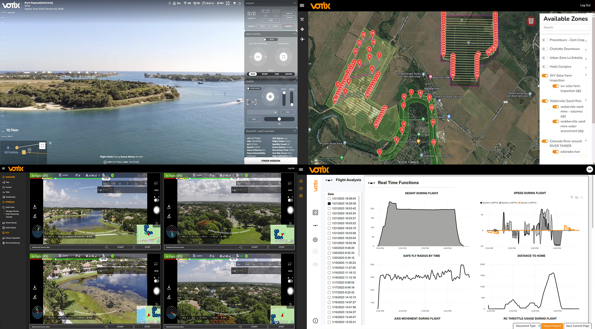
VOTIX has partnered with Iris Automation to enable safe beyond visual line of sight (BVLOS) flights by integrating Iris Automation’s Casia G ground-based detect and alert system into the VOTIX cloud-based UAV operating system.
This integration makes remote operations a reality for enterprises that need effective and flexible UAV BVLOS deployments, from routine automated inspections of critical infrastructure to rapid mobilization seen in UAV as first responder programs.
This hardware-software solution will feed data from the Casia G system into the VOTIX platform to provide a complete picture of the operational airspace in real-time.
The Casia G system can detect non-cooperative or intruder aircraft at a distance by monitoring the airspace and providing their precise location and classification data. This enabes automated conflict resolution via the VOTIX platform.
“Our mission is to make BVLOS easy,” said Ed Boucas, VOTIX CEO. “We have integrated every aspect of drone operation in a single pane of glass so that pilots can easily perform safe and secure BVLOS flights.”
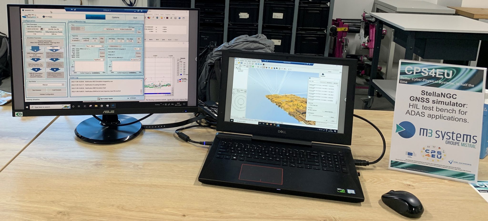
M3 Systems has played an important role in the CPS4EU European project by providing use cases and solutions centered around the company’s GNSS simulator, StellaNGC.
The project aims to develop new Cyber-Physical Systems (CPS) technologies that will improve the efficiency and reliability of critical infrastructures, such as transportation systems, energy networks and communication systems.
The CPS4EU project involves 36 partners from various European countries, including M3 Systems, working to develop new standards and guidelines for the design, deployment and operation of CPS.
The M3 Systems’ flagship product was integrated into a new test bench, to be used by position systems, to assess reliability for autonomous driving and intelligent mobility applications.
In July 2020, my First Fix article discussed the Geodesy Crisis in the United States. In January 2022, Mike Bevis, collaborating with others, prepared a white paper titled “The Geodesy Crisis,” documenting the concern about the lack of trained geodesists in the United States. Since then, my November 2022 survey scene column highlighted that without investment in geodesy, the United States will not have the available skills and knowledge to develop new geodetic technologies and improve models to address challenges to society. In December 2022, Matteo Luccio discussed the urgent need for U.S. geodesists with Everett Hinkley, who works for the federal government, serves as a subject-matter expert on several high-level boards, and dubs himself a “concerned citizen geodesist.”
Well, things are starting to happen. NGS is soliciting grant proposals from eligible organizations to implement activities that modernize and improve the National Spatial Reference System (NSRS) and advance the science of geodesy in the United States. See the image below.
I realize that this is very short notice, but all Letters of Intent (LOIs) must be received no later than Wednesday, March 22, 2023. Full proposals do not have to be completed until April 24, 2023. The grant information and related material can be found here.
This is a great opportunity for institutions of higher education, state, local and Indian tribal governments to partner with industry and private consultants to advance the science of geodesy.