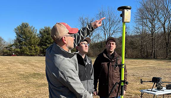
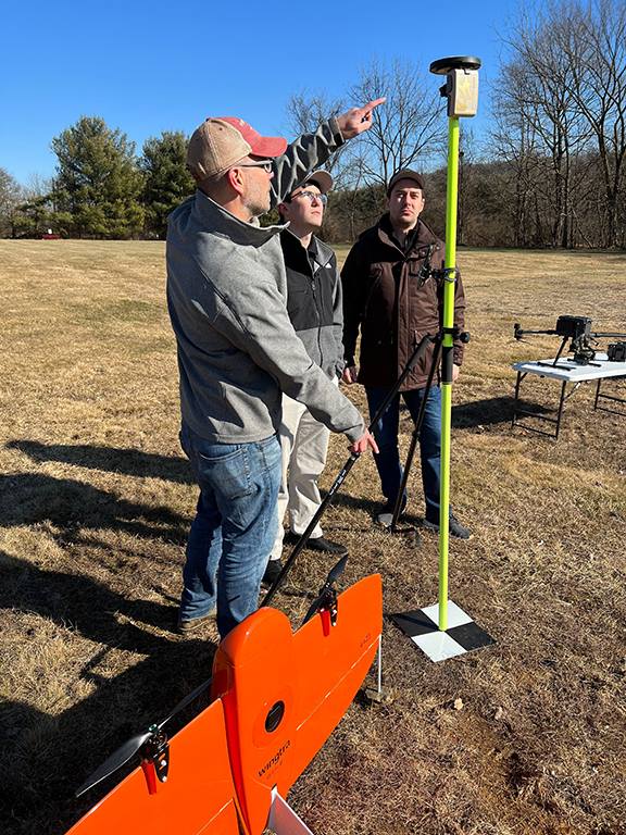
AlphaRTK has signed agreements with Rutgers University, West Chester University and Warren County Community College to provide free access to its GNSS correction network for students and faculty.
The AlphaRTK network — an affordable RTK subscription network that supports four constellations — launched in 2021 and is available for use in New Jersey as well as both the New York City and Philadelphia metropolitan areas.
All institutions perform geospatial research and instruction. Having access to the AlphaRTK network is a powerful resource and will enhance the performance of modern geospatial data collection, the company said.
Warren County Community College specializes in precision agriculture using drones. The AlphaRTK network will provide its fleet with centimeter-level accuracy, advancing analytical capabilities. Rutgers University plans to advance turf farm research, and West Chester University aims to use the network for a geophysics course, among more geospatial research.
AlphaRTK records raw RINEX data that can be used for post-processing workflows, such as with post-processed kinematic drones. Additionally, in southern New Jersey where wireless coverage is weak, Alpha RTK has added ultra-high frequency radio transmitters to broadcast real-time data wirelessly.
The United States Department of Defense (DOD) will provide a new package of security assistance for Ukraine to aid with ongoing Russian aerial attacks. The package includes defense tools such as GPS-guided rockets and counter-UAV equipment.
The presidential drawdown package includes:
additional ammunition for High Mobility Artillery Rocket Systems
additional 155 mm artillery rounds
additional 120 mm mortar rounds
190 heavy machine guns with thermal imagery sights and associated ammunition to counter unmanned aerial systems
181 Mine Resistant Ambush Protected vehicles
250 Javelin anti-armor systems
2,000 anti-armor rockets
Claymore anti-personnel munitions
demolitions munitions
cold weather gear, helmets and other field equipment.
Under the Ukraine Security Assistance Initiative (USAI), DOD will provide Ukraine with:
two HAWK air defense firing units
anti-aircraft guns and ammunition
equipment to integrate Western air defense launchers, missiles and radars with Ukraine’s air defense systems
equipment to sustain Ukraine’s existing air defense capabilities
air defense generators
counter-unmanned aerial systems
four air surveillance radars
20 counter-mortar radars
spare parts for counter-artillery radars
Puma unmanned aerial systems
precision-guided rockets
secure communications equipment
medical supplies
funding for training, maintenance and sustainment.
Ukraine has been able to intercept Russian UAVs and missiles; however, having additional air defense will help combat efforts.
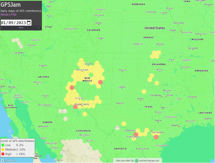
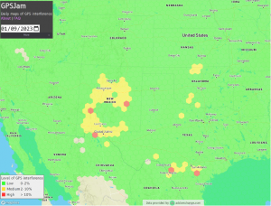
Ever since it came on-line in February 2022, the website GPSJam.org has shown what appears to be regular interference with GPS signals in Texas near San Antonio and Del Rio, and locations north and south of Oklahoma City, Oklahoma.
Only on normal workdays, however. Not on weekends or holidays. Furthermore, whatever was happening also took time off between the Christmas and New Year holidays GPSJam.org also shows similar, though less regular, activity in New Mexico. Experts say this is easily explained as White Sands Missile Range is often the site of electronic warfare training and tests. These are always announced in advance in FAA Notices to Air Missions (NOTAMs) when any interference with GPS reception is anticipated.
The regular patterns observed in Texas and Oklahoma and the lack of NOTAMs led some experts to speculate the source could be inadvertent interference from a commercial or government activity. Said one former official, “It’s just the kind of pattern you see from large organizations. They are off every weekend, federal holidays, and around Christmas.”
Aerobatic-capable Military Training aircraft reporting low NIC values (Image: Stanford University)
GPSJam.org is the brainchild of aviation analyst John Wiseman. The site uses crowdsourced ADS-B reports gathered by the ADS-B Exchange and displays it on a world map. Areas in yellow indicate that between two and ten percent of ADS-B reports for the day had low navigation accuracy. Areas in red had ten percent or more.
Information from the site has proved useful in identifying patterns of regular GPS jamming and spoofing in Russia and other conflict areas around the globe.
The workday patterns in Texas and Oklahoma have appeared on GPSJam.org displays since the site went live in February 2022.
GPS Interference and Aviation
Minor interference with GPS signals is fairly common. GPS jamming devices, while illegal to use, are inexpensive and easy to obtain from vendors on the internet.
Truck drivers wanting to defeat their company’s fleet tracking system, people concerned about being tracked by the government or others, even ministers trying to keep parishioners from texting during sermons – all have been known to use such devices.
Most GPS interference is unintentional. A two-year European Union study found hundreds of thousands of potentially harmful signals, but judged only about ten percent to be intentional. The rest were the inadvertent byproduct of poorly tuned electrical and electronic equipment.
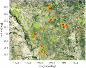
ADS-B tracks of training aircraft performing aerobatics. Red indicates low NIC value reported. (Image: Stanford University)
While most GPS interference is unintentional and localized, spurious signals powerful enough to noticeably impact airborne operations are not unknown.
In two separate incidents last year strong interference near the Denver and Dallas airports impacted air traffic, each for more than a day. The Denver incident lasted for 33 hours before authorities found the source and shut it down. Air traffic was disrupted at Dallas for 44 hours according to government sources, though researchers found the actual interference only lasted for 24 hours. The source of the disruption was never identified.
In 2019 a passenger aircraft was almost lost due to GPS interference while on approach to Sun Valley, Idaho’s Friedman Memorial Airport. As the aircraft flew a GPS-based approach in smoke and haze, the interfering signal was just strong enough to lure it off course and toward a mountain. Fortunately, a sharp-eyed radar controller hundreds of miles away spotted the problem and intervened in time. The source of the interference was never identified.
As a result of the Sun Valley incident and input from numerous aviation groups, the International Civil Aviation Organization told its members there was an “urgent need to address harmful interferences” to satnav signals.
Texas and Oklahoma Mystery Solved
A researcher at Stanford University finally solved the puzzle of the strange recurring sequence of reports from Texas and Oklahoma.
While investigating last October’s GPS interference event near the Dallas airport, PhD candidate Zixi Liu noticed aircraft outside the main area of effect also reporting low Navigation Integrity Category (NIC) values. This began before and continued after complaints from commercial airlines about GPS not being available at Dallas-Fort Worth. These aircraft were in the same general area of Texas, but far enough away that there were large areas between them and Dallas that did not contain any reports with low NIC values.
Low navigation accuracy reports displayed at GPSJam.org. in New Mexico reports were due to GPS interference from military testing. In Texas and Oklahoma, military aerobatics training likely caused reports of low navigation accuracy. (Image: GPSJam.org)
At the same time MS Liu was also investigating anomalous ADS-B reports near San Antonio and Del Rio, Texas. She discovered in all three cases the reports of low NIC values were coming from military training aircraft regularly used for aerobatics. Other aircraft nearby reported good NIC values and showed no evidence interference.
In a recent presentation to the Institute of Navigation, she postulated that Interference with GPS signals was not the cause of the low navigation integrity reports. Rather, the rapid maneuvers and unusual aircraft attitudes of aerobatics caused the airplanes’ navigation receivers to intermittently lose lock on signals from GPS satellites. This caused their ADS-B equipment to report low navigation integrity.
Having solved that mystery, Ms. Liu continues to work on her original question – identifying the source of October’s 24-hour GPS disruption near the Dallas-Fort Worth airport.
Mr. Dana A. Goward is the President of the Resilient Navigation and Timing Foundation and a former US Coast Guard helicopter pilot.
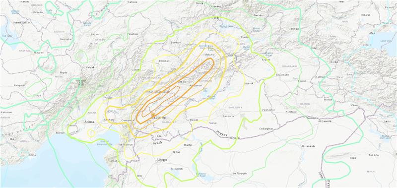
Three earthquakes of magnitude 6 or larger have occurred in Turkiye and northern Syria since 1970. The largest was a magnitude 6.7 earthquake in January 2020. (Credit: USGS)
On Feb. 6, a magnitude 7.8 earthquake struck Turkiye and northern Syria collapsing buildings and killing more than 2,000 people, followed by magnitude 6.7 aftershocks. The impact of the earthquakes was significant and ranks in the red for economic losses and orange for fatalities, according to the United States Geological Survey (USGS).
The USGS reports the earthquake resulted from strike-slip faulting at shallow depths. It appears to be associated with either the East Anatolia fault zone or the Dead Sea transform fault zone.
Historical buildings throughout Turkey have been severely damaged, including the Yeni Mosque and the Gaziantep Castle, which date back thousands of years.
War-torn Syria — specifically Aleppo, Hama and Latakia — have also sustained severe damage to infrastructure that was already fragile.
The effects of this earthquake were felt as far as Lebanon and Israel.
Parts of the historic Gaziantep Castle collapsed, as it lies close to epicenter of the magnitude 7.8 earthquake. (Image: JudyDillon/ iStock / Getty Images Plus/Getty Images)
Historical Gaziantep Castle’s east, south and southeast bastions collapse, leaving debris scattered on the road after major 7.4-magnitude earthquake struck Türkiye’s southeasthttps://t.co/5j2soYI6hCpic.twitter.com/1n6whCr2gY
The Choctaw Nation of Oklahoma (CNO) Beyond Program and uAvionix have received approval from the Federal Aviation Administration (FAA) for beyond-visual-line-of-sight (BVLOS) operations. The approval signifies uAvionix and the CNO have demonstrated to the FAA that the aircraft procedures, detect-and-avoid systems and control network meet the safety requirement for operation in the national airspace.
This is the second BVLOS waiver granted by the FAA for the combinations of uAvionix SkyLine software and SkyLink hardware, allowing UAV pilots operating at the CNO range to use only an electronic observer.
The CNO will be using uAvionix SkyLine command-and-control (C2) management platform and pingStation3 dual-mode ADS-B receivers at the Emerging Aviation Technology Center UAS Test Range. The SkyLine C2 management platform is integrated with the DeTect Harrier radar for surveillance, and is used to control several CNO and uAvionix owned electric vehicle takeoff and landing aircraft through muLTElink and SkyLink series C2 radios.
“Having this capability available at CNO enables our customers to conduct testing and demonstration in Oklahoma and will further serve as guidance for future applications leveraging this concept of operations,” said uAvionix President Christian Ramsey.
Transport Canada has approved Ontario Power Generation (OPG) to operate Percepto’s drone-in-a-box solution beyond visual line of sight (BVLOS) at McConnell Lake Control Dam without a visual observer on site. A BVLOS Special Flight Operations Certificate was issued for the Percepto Air Max autonomous drone-in-a-box for the remote inspection.
The approval enables remote inspection of the dam as a part of a pilot project, which started in January. Since Canadian power utilities are seeking to ensure their power grid and stations are resilient, the OPG facility will gain actionable insights from the remote inspection.
Percepto’s automated drone-in-a-box has been deployed by other electric utilities to monitor the durability of power grid infrastructure and quickly detect problems, enabling faster response times and restoring power quicker after storms and natural disasters.
EagleView Technologies is enhancing EagleView Cloud for government users by adding more imagery options. EagleView Cloud is a resource for government departments including tax assessment, geographic information systems and public safety.
Image: Eagleview
EagleView cloud will now include 1-inch ground sample distance (GSD) aerial imagery. The oblique imagery, usually captured at a 40°- 45° angle, provides enhanced clarity and side-angle views of buildings, homes and properties, enabling government users to view property changes and analyze roads and infrastructure to produce accurate tax assessments.
The company has also added 3-inch GSD orthogonal imagery to the platform. The orthogonal images help government users identify structural changes to buildings, additions to homes, and the condition of impervious surfaces. The images offer a top-down view and can be delivered annually or multiple times per year.
Next, EagleView Cloud aims to be available in commercial industries including insurance, construction and solar.
SandboxAQ has been awarded a Direct-to-Phase-II Small Business Innovation Research contract by the United States Air Force. SandboxAQ will test and evaluate its quantum sensor prototype to help protect military navigation resilience.
Under the contract, SandboxAQ will advance research and development for its quantum navigation system, which is being designed to complement GPS. It will be used for accurate navigation in contested or denied environments where the loss of precision GPS may negatively impact operations.
SandboxAQ’s AQ-powered quantum sensor prototype will be optimized in close coordination with USAF through identified innovation areas, including live demonstrations aboard USAF aircraft. The sensor prototype also has potential for use in the commercial sector for aviation, unmanned vehicles and more.
The Open Geospatial Consortium (OGC) has formed the Geo for Metaverse Domain Working Group (DWG), which will serve as a forum for the collective geospatial expertise of the OGC community to gather to help build and expand the open Metaverse. The group is open to both OGC members and non-members.
The group plans to contribute its expertise in 3D, modeling and simulation, artificial intelligence, digital twins, streaming, augmented and virtual realities, routing, mapping and more — all at scale.
The group will work on pieces of the Metaverse that pertain to geospatial applications and standards by identifying standardization activities and best practices based on FAIR (making data Findable, Accessible, Interoperable and Reusable) data principles.
The DWG will be the primary point of contact with the Metaverse Standards Forum, of which OGC is a founding and principal member.
3D geospatially anchored data is powering innovation across a range of industries. This same data — relied upon for construction of the real world — is now driving the creation of virtual/digital worlds that will form parts of the Metaverse.
ADVA and Brandywine Communications have partnered to provide a defense-grade M-code device with advanced timing, the OSA 5422 grandmaster clock, for military applications. ADVA’s OSA 5422 meets key requirements of military networks by providing advanced positioning, navigation and timing (PNT) capabilities and improved resilience.
ADVA’s OSA 5422 grandmaster clock is integrated with a highly reliable M-code receiver, which meets stringent frequency and phase synchronization needs. The device is equipped with multi-band, multi-constellation GNSS receivers for when M-code is not available. OSA 5422 also has long holdover and precision time protocol backup, which enables it to maintain accurate timing even in the event of M-code disruption.
The OSA 5422 supports legacy interfaces such as BITS and IRIG and features eight field-upgradable 10G bit/s ports and 1G bit/s interfaces. The device is suitable for most demanding military edge applications.
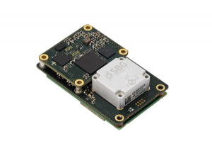
SBG Systems has released Quanta Plus, a GNSS-aided inertial navigation system (INS). Quanta Plus is a small, lightweight product, which can be easily integrated into survey systems with lidar or other third-party sensors.
The device combines a micro-electromechanical (MEMS) inertial measurement unit (IMU) with a resilient GNSS receiver to get reliable position and attitude, providing real-time kinematic (RTK) fixes.
Quanta Plus includes motion profiles, which enable users to optimize the sensor parameters to suit different use cases. The built-in precise time protocol server ensures sub-microsecond synchronization with external devices such as lidar. The device also has a built-in datalogger, Ethernet interface for easy integration, and a web configuration interface for simple setup and control.
The INS can be integrated with Qinertia, SBG System’s post-processing software. Qinertia improves the performance of acquired data during a mission using reliable RTK corrections from a wide range of continuously operating reference station networks, or by importing base-station data during the process.
Quanta Plus also improves the accuracy of the position and attitude using forward and backward processing and by integrating a tight coupling between GNSS and IMU data.
Quanta Plus is suitable for survey professionals or a navigation-dependent company seeking a robust navigation device. Specific solutions are available for integrators and OEMs who want to use Qinertia as a component in their application-specific data-processing solutions.
Inertial Labs has released a remote sensing payload instrument. The Resepi Hesai XT32 laser is designed for accurate remote-sensing applications. The Resepi laser can be used with commercially available lidar scanners, including Velodyne, Quanergy, Ouster, RIEGL, LIVOX and Hesai, as well as with UAVs.
Resepi is completely modular, so users have full control for customization. The remote sensing device uses a GPS-aided inertial navigation system with NovAtel RTK/PPK single- or dual-antenna GNSS receiver, integrated with a Linux-based processing platform. It also comes with a 2 TB USB memory drive and has an embedded Wi-Fi cellular modem.
Resepi has 3-5 cm point-cloud accuracy and can reach heights of more than 200 m above ground level. It is compatible with most UAV models; however, it is typically used with DJI M300, DJI M210 or DJI M600 models.
The device is suitable for scanning and mapping, precision agriculture with lidar, simultaneous localization and mapping (SLAM) algorithm development, utility inspection and construction site monitoring. Resepi-supported software includes Hexagon NovAtel, PCPainter and PCMaster.