GNSS receivers are now routinely integrated into every kind of vehicle, vessel and aircraft, often in conjunction with other technologies that can be used for positioning and navigation, such as inertial navigation, radar, lidar, sonar and computer vision. This month’s cover story highlights case studies from Hexagon, Orolia, Trimble, CHC Navigation and XenomatiX that increase safety, improve service, lower costs and reduce emissions.
Blog
-
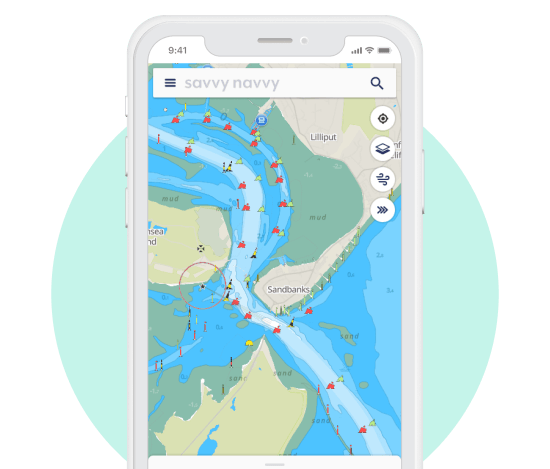
Waterway Guide and marine tech company savvy navvy enter partnership
A new partnership between all-in-one navigation app and Waterway Guide gives U.S. boaters an enhanced user experience, integrating comprehensive marina details and user reviews into the navigation app.
The savvy navvy app, described as “Google Maps for boaters”, has grown by 132% this year in the United States.
Waterway Guide is a resource for cruising boaters. Its data on more than 4,000 marinas and thousands of anchorages are now integrated into the savvy navvy app for all the users to access.
“One of the most significant factors in deciding where to go with your boat is reviews from other boaters,” said Jelte Liebrand, CEO and founder of savvy navvy. “With a wealth of information on all marinas and anchorages and honest reviews, it’s an amazing addition to our offering for our growing American customer base.”
Image: savvy navvy Liebrand, a former Google software engineer and avid sailor based in the UK, developed and launched savvy navvy, bringing an all-in-one navigation solution to the market. This season alone savvy navvy users have plotted more than 40 million nautical miles of routes. Earlier this year, the navigation app launched a freemium plan and functionalities for paddleboarders, kayakers and jet skiers.
Waterway Guide is continuously updated by a network of on-the-water contributors, marina partners, NOAA data, the Waterway Guide team, and crowd-sourced information.
Data from the Waterway Guide is live in the savvy navvy app for users to see now when pressing the blue POI icons across the United States and Canada, giving users information on services and facilities alongside marina reviews.
-

Linx Technologies launches surface-mount embedded GNSS antenna
Photo: Linx Linx Technologies, now part of TE Connectivity, has expanded on its Splatch antenna series with the release of the ANT-GNL1-nSP, a surface-mount embedded GNSS antenna supporting GPS, Galileo, GLONASS, Beidou and QZSS in the L1/E1/B1 bands.
“The new linear GNSS antenna from Linx expands upon our already robust embedded PCB antenna portfolio of customer favorites like the uSP410, SP610 and the nSP250, by adding a GNSS solution,” said Rick Stuby, vice president of product management. “The antenna displays high performance in a compact surface-mount package, making it especially well-suited for small devices in the growing internet of things market.”
The ANT-GNL1-nSP antenna exhibits notable performance in a compact size (10 mm x 8 mm x 1 mm) and features linear polarization and an omnidirectional radiation pattern. The antenna is available in tape and reel packaging and is designed for reflow-solder mounting directly to a printed circuit board for high-volume applications.
The new GNSS antennas are available now via Linx Technologies’ distributor and manufacturer representative networks. For larger quotes, email Linx Technologies at [email protected].
-

DOD office recommends D-Fend solution to counter rogue drones
The recommendation is based on demonstrations at Yuma Proving Ground, Arizona
In September 2021, EnforceAir helped safeguard Pope Francis and a crowd of 60,000 in Slovakia. A ground-level tactical kit provided 360-degree azimuth coverage, fending off a rogue drone and sending it back to its original takeoff position. (Photo: D-Fend) EnforceAir, a solution that counters small unmanned aerial systems (sUAS), has been recommended by the U.S. Department of Defense’s (DoD) Joint Counter-sUAS Office (JCO).
Developed by D-Fend Solutions, EnforceAir was recommended as a subcomponent integrated within SAIC’s Valkyrie C2 system.
EnforceAir was recognized for its RF detection and mitigation, its demonstrated impressive effectors and its ability to force land certain drones. D-Fend Solutions’ EnforceAir was the only RF cyber takeover technology named.
EnforceAir automatically executes cyber drone detection and takeover mitigation of rogue drones for safe landings and outcomes, empowering security agencies and professionals with control while preserving operational continuity.
The JCO recommendation is the result of a formal U.S. government evaluation event held at Yuma Proving Ground in April 2022.
“It’s an honor to be recognized by the U.S. DoD Joint C-sUAS Office, following a rigorous demonstration and evaluation” said Zohar Halachmi, Chairman and CEO of D-Fend Solutions. “We’re excited to provide continued support for the counter-drone mission, within a layered defense, integrated in the most advanced C-UAS systems for the nation’s defense.”
EnforceAir is D-Fend’s flagship offering. With hundreds of deployments worldwide, EnforceAir focuses on the most dangerous drone threats in the military, public safety, airport, prison, major event and critical infrastructure environments.
-

Orolia’s rescue beacons head to US Army
Latest Orolia Defense & Security personal rescue beacons deliver Cospas-Sarsat second-generation signaling
Photo: DVIDS Orolia Defense and Security is now shipping its PRSS1b Personnel Recovery Devices to the U.S. Army. The beacon uses a commercial GNSS chipset that can be replaced by SASSM or M-Code-capable receivers depending on customer needs.
Orolia’s PRSS1b PRD provides second-generation Cospas-Sarsat signaling that delivers faster and greater location accuracy than previously fielded tactical location devices.
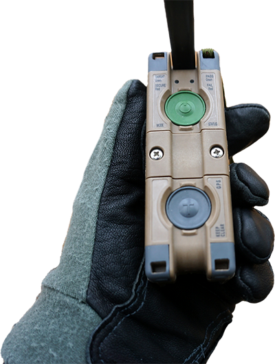
Photo: Orolia Cospas-Sarsat is an international, humanitarian search-and-rescue system that uses space-based technology to detect and locate model 406 emergency beacons carried by ships, aircraft or individuals venturing into remote areas, often inaccessible by mobile phone. The system consists of a network of satellites, ground stations, mission control centers (MCCs) and rescue coordination centers (RCCs) that work together when a 406 beacon is activated.
Through collaboration with the Army, Orolia produced a robust, user-friendly and highly reliable device to locate personnel who become isolated, missing, detained or captured.
Orolia conducted a demonstration in October simultaneously on multiple continents, showing its technology working with the worldwide coverage provided by the Cospas-Sarsat infrastructure. The demonstration yielded beneficial data to support the qualification of Orolia’s Personnel Recovery Device and helped inform government stakeholders on the readiness of the second-generation ground and satellite infrastructure.

A U.S. Army HH-60 Black Hawk helicopter lowers a volunteer from Central Washington Mountain Rescue via the hoist system during a training exercise.(Photo: U.S. Army) Also in October, Orolia received Cospas-Sarsat certification for its Ultima-DT ELT emergency transmitter, designed for use on aircraft. All 406-MHz emergency beacons are digitally coded and transmit distress signals immediately upon activation on a proprietary radio wavelength.
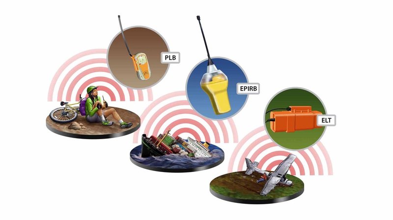
The three main types of 406 distress beacons and the kinds of situations for which each is designed: wilderness, marine and aviation environments. (Image: Cospas-Sarsat) -

HERE powers hands-free driving for BMW
The BMW 7 Series rolls out SAE Level 2+ at a speed of 130 km/h in the United States and Canada. HERE also provides the BMW 7 Series with Predictive Routing and Real-Time Traffic information.
BMW Group is using the HERE Technologies HD Live Map to enable hands-free driving in the United States and Canada, starting with its 7 Series.
Following a long-standing collaboration between BMW and HERE on next-generation mapping capabilities, HERE now provides high-definition maps for Level 2+ automated driving capabilities in series production vehicles.
The BMW 7 Series is the automaker’s first production vehicle to launch with SAE Level 2+ automated functionalities at a maximum speed of 80 mph (130 km/h). The function enables hands-free driving on interstates and highways, provided drivers remain focused and ready to take control.

Photo: HERE Technologies The HERE HD Live Map will be integrated into additional BMW models as automated driving capabilities increase across vehicles, roadways and regions.
The HERE HD Live Map consists of rich, highly accurate and fresh layers of data to support the vehicle in knowing exactly where it is on the road, and what road features lie ahead.
HERE HD Live Map helps a vehicle to proactively adjust its behavior to upcoming road characteristics.The lane-level data serves as a redundant source of information to the onboard sensors, providing additional safety assurances for the system.
Photo: BMW The BMW 7 Series is also the first vehicle to deploy HERE Predictive Routing, a cloud-based routing functionality that learns individual driving patterns to propose more personalized journeys.
In addition, the BMW 7 Series uses HERE Real-Time Traffic across 70 countries. The service delivers drivers detailed information on traffic congestion with lane-level precision and potential road hazards ahead, with auto re-routing capabilities, helping drivers stay safe and save time.
-

Brazilian operator adopts 5G high-precision protocol with Microchip Technology
TIM Brasil’s partnership with Microchip Technology provides the accuracy needed for high-performance network architectures, enabling more efficient data transmissionNow that it has implemented 5G coverage in all Brazilian state capitals, network operator TIM Brasil has enabled precision time protocol (PTP) in its commercial 5G service.
To accomplish this, TIM has partnered with Microchip Technology, supplier of the TimeProvider 4100 technology, which allows full compatibility and meets the stringent synchronization requirements of 5G mobile network standards.
PTP allows precise synchronization and times that can reach nanoseconds among cellular base stations, with security of the data transmitted, by encryption.
Signal synchronization is essential for a successful 5G consumer experience, ensuring better performance, including reduced latency, more accuracy and better transmission quality.
“The evolution of the 5G offer by the operator does not occur only in the expansion of coverage, but in the possibility of providing the evolution of the service to the consumer,” said Marco Di Costanzo, network director at TIM Brasil. “We want TIM customers to be able to enjoy 5G networks with the best possible experience.”
He added, “We are satisfied with the easiness of management and robustness of the new TimeProvider 4100, perceived during our extensive field trials, and we are confident this is a perfect match for the demanding requirements in our mobile deployments. It’s a robust synchronization platform, with high scalability, capacity and flexibility for future growth needs.”
Tests of the new technology were carried out after TIM’s implementation of 5G networks in Brazilian state capitals, and prove the evolution of the service already used by TIM in its partnership with Microchip for the last 10 years.
The application of the TimeProvider 4100 technology can have a positive impact on the reduction of latency time and can help improve the signal distribution in indoor networks.
“Our TimeProvider 4100 offers a robust solution with the flexibility to deploy in a wide range of environments accommodating standards required for mobile 5G implementations due to its impressive versatility,” said Randy Brudzinski, corporate vice president for Microchip’s Frequency & Time Systems business unit. “The device uniquely provides a 1588 grandmaster supporting these standards with the high-precision, accuracy and reliability requirements needed for leading mobile operators like TIM Brasil.”
-

Fugro joins forces with Carbonix on remote aerial operations
The Carbonix Volanti vertical take-off and landing (VTOL) drone. (Photo: Carbonix) Fugro is partnering with Australian drone manufacturer Carbonix to establish a new long-range drone capability. It is Fugro’s first partnership working towards long-range beyond-visual-line-of-sight (BVLOS) missions, bolstering Fugro’s existing geographic information system (GIS) capability.
Carbonix will supply Volanti and Ottano vertical take-off and landing (VTOL) drones over the next 27 months, to further enhance Fugro’s remote operations.
Fugro is engaged in the transition to remote and autonomous operations with a global network of nine remote operation centres (ROCs). From these centers, Fugro operates boats and other vehicles, and provides survey, inspection and piloting services to the global maritime industry.
Carbonix will support Fugro’s Australian long-range maritime and land projects from the sky, using aerial surveying and data-capture technology, while integrating with Fugro’s ROCs for the joint development of systems technology and capabilities.
-
Inexpensive sensor created to monitor Rhine river levels
A team of researchers has developed a low-cost sensor that can detect the changes in river height to provide wide-area flood warnings.
The Raspberry Pi Reflector (RPR) was designed by a team of scientists from the University of Bonn, the Federal University of Rio Grande do Sul, and the University of Colorado.
The solar-powered RPR is much less expensive (about US$150) than scientific-grade or geodetic GNSS instruments — the cost of which is “a limiting factor for their prompt and more widespread deployment as a dedicated environmental sensor,” the team writes in their paper.
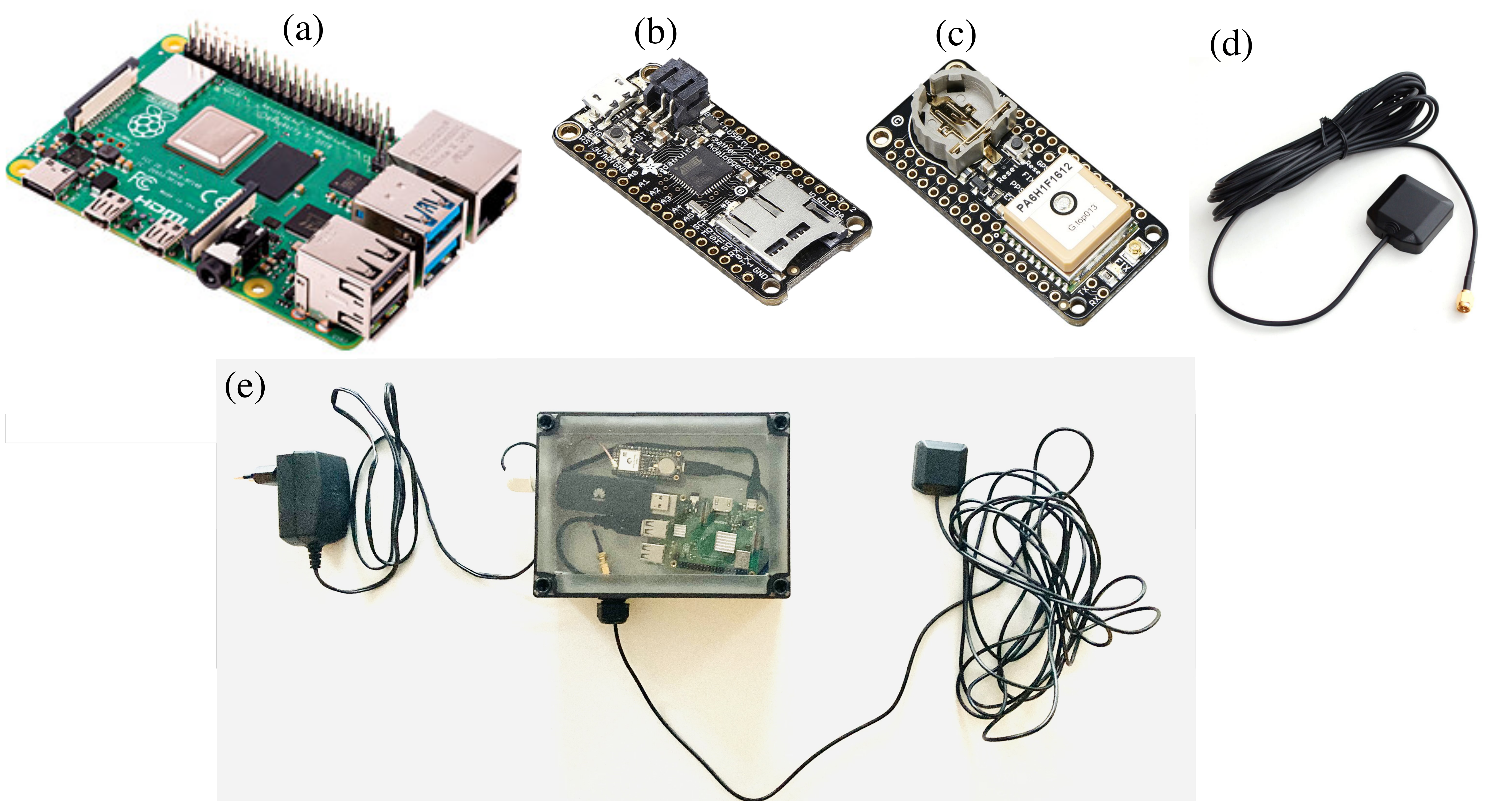
The Raspberry Pi Reflector (RPR) prototype includes a low-cost and low-maintenance single-frequency GPS module (an Adafruit GPS FeatherWing receiver) and an unspecified GPS antenna connected to an inexpensive Raspberry Pi microcomputer. One such unit has been successfully operating since March 2020 in Wesel, Germany, next to the Rhine river.
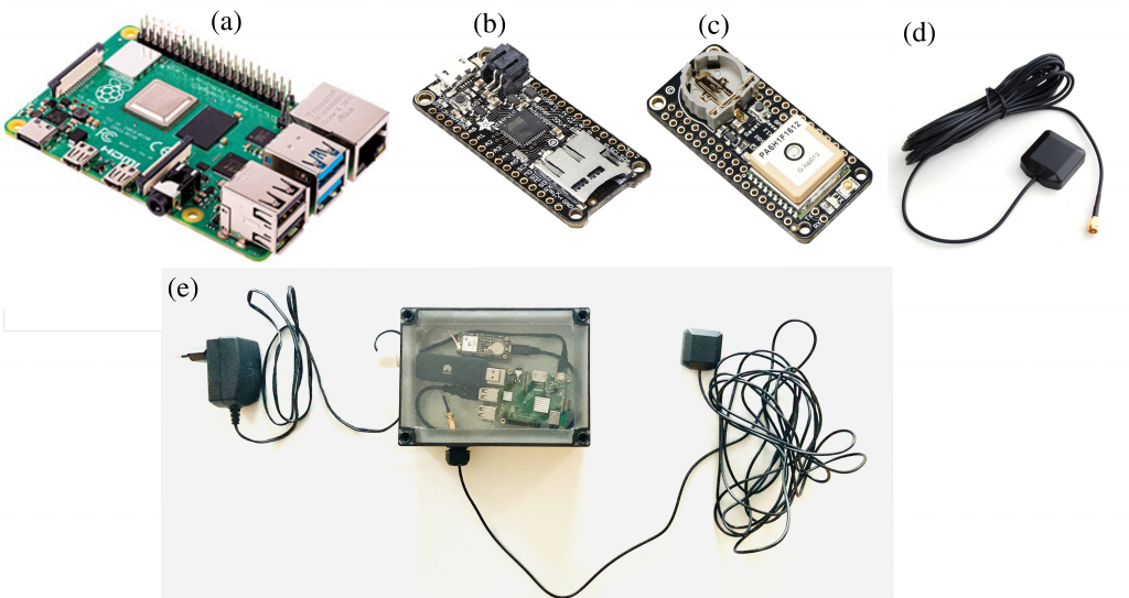
The RPR hardware array: (a) Raspberry Pi 4 Model B (b) Adafruit Feather Adalogger microcontroller (c) Adafruit GPS FeatherWing receiver (d) GPS external antenna (e) Configuration of RPR prototype setup. (Image: Karegar, et al) The unit on the Rhine provides sub-daily and daily water levels retrieved using spectral analysis of reflection data, or GNSS-reflectometry. The river level measurements from the RPR are compared with a co-located river gauge.
By changing the orientation of the antenna from upright to sideways facing the river, which was done in August 2021, the root-mean-square error (RMSE) was lowered to from 7.6 cm to 3 cm (sub-daily) and 6 cm to 1.5 cm (daily), the team said.
“While satellite radar altimetry techniques have been utilized to monitor water levels with global coverage, their measurements are associated with moderate uncertainties and temporal resolution,” the team states. “Therefore, such low-cost and high-precision instruments can be paired with satellite data for calibrating, validating and modeling purposes.”
Information about the RPR is available on GitHub.
-

Advanced Navigation completes Series B funding round
Advanced Navigation, a developer of AI robotics and navigation technology, has raised $68 million in a Series B funding round. The Series B round was led by global investment firm KKR.
The funding round includes participation from new investors such as deep learning venture firm AI Capital and existing investors, including Main Sequence, the Hon. Malcolm Turnbull AC, In-Q-Tel, and Our Innovation Fund, bringing Advanced Navigation’s total amount raised to more than $85 million.
Advanced Navigation supplies solutions to some of the world’s largest tech companies, such as Fugro, NASA, Tesla, Google and Boeing. The funding will be used to develop AI technologies and expand autonomy beyond its current scope, including solutions to help guide driverless vehicles, flying taxis, space crafts, drone deliveries, autonomous farming and deep sea robotics. The company will also assess inorganic growth opportunities to incorporate new technologies and products into its suite which complement the company’s existing products and areas of expertise.
Louis Casey, KKR’s growth technology lead in Australia, New Zealand, and Southeast Asia, said, “Advances in autonomous navigation technology that leverages AI to reduce sensor cost while improving performance can rapidly increase enterprise and consumer applications globally. We are very pleased to work alongside the Advanced Navigation team to support the company’s growth.”
In addition, Louis Casey and Vance Serchuk, Executive Director of the KKR Global Institute, will join Advanced Navigation’s board of directors. General David Petraeus (U.S. Army, Ret.), Partner, KKR and Chairman of the KKR Global Institute, will chair a new advisory committee that targets to support the company’s global expansion efforts.
-
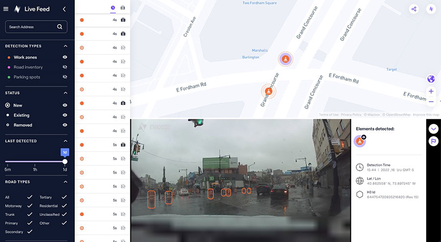
Nexar releases CityStream Live, a real-time mapping platform for mobility
Image: Nexar The new platform is designed to provide fresh data on nearly every road across the U.S. at a reduced cost
Nexar, an artificial-intelligence (AI) computer vision company, has released CityStream Live, a real-time mapping platform.
CityStream Live enables the mobility industry, including connected vehicles, maps, mobility services, digital twins or smart city applications, to access a continuous stream of fresh, crowdsourced road data. Only with real-time data can vehicles really know what’s coming their way, react to varying speed limits, avoid work zones, find parking and someday drive themselves. Thanks to Nexar’s massive network of “eyes on the road,” edge AI and change-detection capabilities, CityStream Live is already available to industry design partners.
Today’s digital maps often fall short of the freshness and precision that software-driven auto OEMs, autonomous vehicles, and mobility players require. Standard mapping methods — SD, HD and traffic maps — fail to provide accurate, up-to-date and cost-effective solutions, Nexar said.
To solve this problem, CityStream Live provides real-time mapping technologies at the edge of the network, enabling detection of work zones, road sign changes, potholes and free parking spaces. The platform is designed to provide fresh data on nearly every road across the United States at a dramatically reduced cost.
CityStream Live uses a crowdsourcing network and edge AI software to provide developers with a live data feed to increase situational awareness, enhance driving capabilities, increase safety, add comfort and help solve everyday mobility challenges.
More than 700,000 vehicles are in in Nexar’s camera network, which captures 94% of U.S. roads each month. Nexar collects 3 billion miles of road vision data per year.
A free trial version of CityStream Live can be accessed here.
-

Swift Navigation adds tiers, BeiDou support to Skylark service

(Image: Swift Navigation) Swift Navigation has expanded the capabilities of its Skylark precise positioning service to several product tiers. With new services providing real-time kinematic (RTK) and differential GNSS (DGNSS) options, Swift meets the broadening needs of its growing customer base.
In addition, new BeiDou signal support and regional coverage has been added.
Skylark is Swift’s cloud-based GNSS corrections service designed to deliver affordability, high accuracy and fast convergence, eliminating the complexity of deploying and maintaining GNSS networks. The expansion of Skylark’s capabilities makes it possible for customers across industries to benefit from seamless corrections to applications across the globe, the company said.
Skylark RTK delivers Swift’s highest tier of performance to third-party GNSS receivers. Compatible with leading RTK receivers on the market, Skylark RTK delivers corrections for applications that require sub-2 cm accuracy, including agriculture, machine control, drones and robotics in the United States, Europe and select Asian countries.
Skylark DGNSS is suitable for mobile applications, delivering real-time, high-reliability differential GNSS corrections to mobile handsets, positioning engine modules and mass-market applications. Skylark DGNSS enables lane-level location accuracy, in turn enabling new consumer location experiences and improving location-based services to increase efficiency on a global basis.
With BeiDou coverage already available across the United States, Japan and Korea, Swift has now added BeiDou signal support for the European Union, supplementing existing support for Galileo and GPS by providing corrections for GPS L1/L2/L5, Galileo E1/E5b/E5a and BeiDou B1/B2a. In addition, support for BeiDou B1C has been added to all regions.
These additions help support newer mass-market RTK-enabled receivers to achieve high-accuracy performance in difficult GNSS environments and continue to push the envelope for positioning accuracy.
“Swift was founded on the notion of improving GNSS positioning performance for mass-market applications,” said Holger Ippach, executive vice president of product, Swift Navigation . “We are pleased to expand the functionality of Skylark to improve the positioning functionality for many more customers across the globe.”
The suite of Skylark products was built from the ground up for scale, resilience and ease of integration. Skylark delivers seamless corrections to continents and countries across the globe including the United States, Europe, South Korea, Japan, Taiwan and Australia.