At its meeting Nov. 2-11 in London, the IMO Maritime Safety Committee adopted a resolution to approve the BeiDou Message Service System (BDMSS) for use in the Global Maritime Distress and Safety System (GMDSS).
The GMDSS is an internationally recognized distress and radio communication safety system for certain-sized ships under the IMO Safety of Life at Sea Convention (SOLAS). The automated ship-to-shore and ship-to-ship system uses navigation satellites and terrestrial radio systems with digital selective calling technology.
The meeting summary states:
Following the assessment and evaluation of an application by China Transport Telecommunication Information Group Co. Ltd. (CTTIC) to recognize the BeiDou Message Service System (BDMSS) for use in the GMDSS, the MSC adopted an MSC resolution on Statement of recognition of the maritime mobile satellite services provided by CTTIC through BDMSS.
BDMSS was evaluated taking into account the existing requirements of the criteria for the provision of mobile satellite communication systems in the GMDSS (resolution A.1001(25)).
The recognition is currently limited to a coverage area within 75°E to 135°E longitude and 10°N to 55°N latitude.
BeiDou is the third system approved for GMDSS, following Inmarsat and Iridium, both of which use GPS and Galileo to provide tracking services.
The BLK2FLY, recognized for its productivity and innovation, is a fully integrated autonomous flying laser scanner. It’s part of Hexagon’s BLK suite of autonomous reality capture sensors designed for speed, portability, ease-of-use and mobility.
To compile the list, TIME solicited nominations from TIME’s editors and correspondents around the world, and through an online application process, paying special attention to growing fields — such as the electric vehicle industry, green energy and the metaverse. TIME then evaluated each contender on key factors including originality, efficacy, ambition and impact.
“Having our reality capture technology recognized by TIME as one of the year’s best inventions is both humbling and inspiring. It validates our mission to build Smart Digital Realities that empower an autonomous, sustainable future,” said Hexagon President and CEO Ola Rollén. “Our technologies aim to change the world for the better, turning concepts that were once thought impossible into real solutions that benefit everyone. By optimizing quality, productivity, efficiency and safety — profitably — we can help industry achieve sustainability through mitigated risk, less waste and reduced cost.”
As a lidar-based unmanned aerial vehicle (UAV), the BLK2FLY addresses costly and complex issues, quickly and accurately capturing everything from large outdoor spaces to complex structures and environments.
For example, when renovating building structures, it can easily capture the exterior dimensions of previously inaccessible or difficult-to-reach areas such as rooftops and facades. The resulting colorized 3D point clouds are instrumental in building information modeling (BIM) processes, documenting site conditions and improving an asset’s operation, from infrastructure to utilities to industrial facilities.
ESTEC Test Centre, Europe’s largest satellite testing facility, said goodbye on Nov. 14 to the final satellite in the Galileo First Generation series, as it departed to OHB in Germany. There, it will rest in storage until ready to be sent for launch.
In a new European Space Agency (ESA) video, the people responsible for readying the satellites for space have gathered to reflect on the end of an era.
The work on Galileo began two decades ago with two test Galileo In-Orbit Validation (GIOVE) satellites, followed by a series of operational launches. The two GIOVE satellites and all 34 Galileo Full Operational Capability satellites were tested at ESTEC.
Next will come the Galileo Second Generation satellites, already in development.
The Institute of Navigation is seeking abstracts for the 2023 Joint Navigation Conference (JNC 2023) for the Department of Defense and Department of Homeland Security. The Military Division of the Institute of Navigation will host the conference taking place June 11-15 in San Diego.
The exhibit hall will be open to all conference participants, exhibitors, their employees and related organizations. All materials displayed in the exhibit hall shall be Publically Releasable After Review.
The theme of this year’s conference will be “Enhancing Dominance and Resilience for Warfighting and Homeland Security PNT”.
JNC is the largest U.S. military Positioning, Navigation and Timing (PNT) conference of the year with joint service and government participation. The event will focus on technical advances in PNT with an emphasis on joint development, testing and support of affordable PNT systems, logistics and integration.
The conference will also focus on advances in battlefield applications of GPS; critical strengths and weaknesses of field navigation devices; warfighter PNT requirements and solutions; and navigation warfare.
Abstracts must be written for public release with the intent to present in a Controlled Unclassified Information (CUI) U.S. only environment. Abstracts not approved for public release will not be accepted. Abstracts should be submitted via ion.org/abstracts by February 3.
Europe’s 2nd Horizon Europe call has been launched for European GNSS, Galileo and Earth observation projects, offering total funding of €48.1 million.
The Horizon program is managed by the European Union Agency for the Space Programme (EUSPA). It funds research and innovation by small and mid-size enterprises, academia, public actors and others that will stimulate development of space applications and solutions using EUSPA data and services.
The 2nd call aims to to strengthen downstream capabilities and modernize the EU public sector by offering cutting-edge solutions based on Galileo, Copernicus, EGNOS and GOVSATCOM.
Funding is being offered for projects that make use of Galileo and EGNOS in smart mobility applications. Other projects fuse Copernicus data with artificial intelligence to boost the European economy and help modernize the public sector. For the first time, the call seeks to deliver satellite communication use cases based on the forthcoming GOVSATCOM system.
Below is a breakdown of the funds’ distribution per thematic area.
Visit the EU’s funding & tender opportunities portal for detailed information about the EUSPA call and the topics available. The deadline for applications is March 2, 2023.
Septentrio’s mosaic-T is built specifically for resilient and precise time and frequency synchronization under challenging conditions. (Photo: Septentrio)
Fugro has signed a tri-party cooperation agreement with GNSS receiver company Septentrio and synchronization equipment manufacturer Meinberg to launch the Fugro AtomiChron real-time synchronization and authentication service.
Numerous sectors rely on resilient and highly accurate time synchronization, including telecommunications, finance and energy. The timing technology eliminates time drift caused by clocks counting time at slightly different rates, and provides extreme stability that surpasses current precision frequency standards.
With up to sub-nanosecond accuracy, Fugro AtomiChron includes Navigation Message Authentication (NMA), ensuring reception of genuine GNSS signals and time synchronization improvements. Integrated anti-spoofing detection further prevents interference with GNSS timing signals providing accuracy, authentication, validity and security for end users.
The agreement ensures that the Fugro AtomiChron service will be available in new Septentrio mosaic-T GNSS receivers, as well as a selection of Meinberg GNSS clocks, without the need for additional physical interfaces or separate antennas.
“Septentrio is a forerunner in the area of robust and resilient GNSS solutions,” said Jan Van Hees, business development director at Septentrio. “With the addition of the unique Fugro AtomiChron service, we are pleased to further strengthen our offering and provide our customers even more accurate and reliable solutions for resilient GNSS timing.”
A roundup of recent products in the GNSS and inertial positioning industry from the November 2022 issue of GPS World magazine.
OEM
GNSS Module
For UAV, precision agriculture and autonomous machines
Photo: Unicore Communications
The UM982 GNSS module is a high-precision, dual-antenna real-time kinematic (RTK) positioning and heading module. It supports BeiDou B1I/B2I/B3I; GPS L1/L2/L5; GLONASS L1/L2; Galileo E1/E5a/E5b, QZSS L1/L2/L5; and SBAS in dual-antenna mode. The highly integrated, compact (16 mm × 21 mm × 2.6 mm) module can reduce the design area of an OEM board by 72% compared to previous modules. Power consumption is less than 0.6 W. The NebulasIV GNSS system-on-chip is a key part of the UM982’s navigation system. The NevulasIV integrates RF, baseband and high-precision algorithms on a single chip, with supporting functions built in. High-level performance indicators include raw observation accuracy, RTK positioning accuracy, precise point positioning accuracy, and time to first fix. The two antennas can independently participate in deriving an RTK solution and outputting the positioning results.
Alternative to ceramic patch provides omni-directional performance
Photo: Antenova
The Agosti (part number SR4G080) is a new miniature surface-mount-designed (SMD) antenna for GNSS applications. It measures 9.0 mm x 5.8 mm x 1.7 mm and operates with exceptional efficiency in a reduced space on a corner of a printed circuit board. It has a small ground-plane requirement of 40 mm x 20 mm, 70 mm x 25 mm and 80 mm x 30 mm, making it suitable for small form-factor designs such as wearable devices, trackers and onboard diagnostics.
Housed Dual-Band antenna with Accutenna technology
Photo: Tallysman
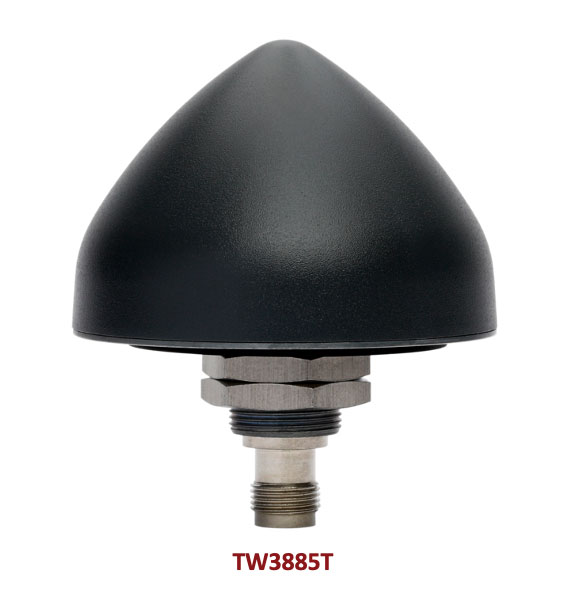
The dual-band TW3885T antenna supports GPS/QZSS L1/L5; Galileo E1/ E5a/b; BeiDou B1/B2/B2a; GLONASS G1/G3; and satellite-based augmentation systems in the region of operation: WAAS (North America), EGNOS (Europe), MSAS (Japan) or GAGAN (India). It is housed in a through-hole mount, weatherproof (IP69K) enclosure. It mitigates the effects on GNSS receivers of new signals or harmonic frequencies from adjacent LTE bands on the radio-frequency spectrum. For permanent installations, L-bracket (PN 23-0040-0) or pipe (23-0065-0) mounts are available. Tallysman provides an antenna installation guide that recommends a 100 mm –125 mm ground plane and provides antenna installation and cable connector waterproofing best practices.
Simplifies product development for high-precision applications
Photo: Taoglas
The TFM.110A is the first in a new series of high-precision, multi-band GNSS front ends for autonomous vehicles, precision agriculture, automotive applications and robotics. It comes fully integrated with two cascaded low noise amplifiers (LNA) and pre-filters in a small, low-profile, shielded surface-mount package. When used between the device’s GNSS receiver and antenna, the two-stage amplifier solution eliminates the need for complex and challenging onboard filter and amplifier circuits. It supports L1, L2 and L5 bands and enables seamless signal transmission, signal purity and position accuracy in high-precision applications.
Provides interference, spoofing, encryption and authentication capability
Photo: IFEN GmbH
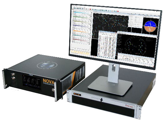
Version 2.8 of the NCS Nova RF signal simulator offers advanced capabilities. With integrated interference generation capability, the Nova can generate coherent interference signals with a signal power of up to –30 dBm. The ability to assign two users to one RF output enables integrated spoofing scenarios with a single RF output, meaning spoofing is available even with an entry-level single RF Nova. The new release has advanced navigation message authentication simulation capability compliant to User ICD 1.0 for the Galileo E1-B OSNMA, meaning specific OSNMA events can be simulated — key to ensuring compliant receiver behavior. Supported events include renewal and revocation of both a public key and a TESLA keychain. GPS cross-authentication and generation of Galileo E6-C encrypted codes are also supported.
Enables first responders to locate callers on floor levels
Photo: Polaris Wireless
Z-axis location service enables the pinpointing of a smartphone user within one floor level inside a multi-story building. The technology — demonstrated to meet the 3-meter vertical location accuracy requirement of the Federal Communications Commission (FCC) — is integrated into Schok Gear’s newly released flip phones. The Schok phones provide consumers with a simple, powerful device. Adding indoor and vertical location to these phones enables first responders to locate all wireless 911 callers with floor-level accuracy in multi-story buildings.
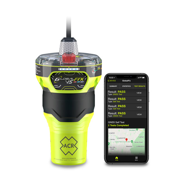
The new ACR Electronics GlobalFix V5 Emergency Position-Indicating Radio Beacon (EPIRB) and ResQLink AIS Personal Locator Beacon (PLB) have integrated the automatic identification system (AIS) to increase the speed of location and aid. They also are compatible with Return Link Service (RLS) alerting. The combination of services ensures faster rescue and increases chance of survival of both boat (EPIRB) and crew (PLB). The safety beacons deliver mobile connectivity to a cell phone with a free mobile app, made possible with the addition of near-field communication technology in the beacons. With the app, users can monitor their beacons, review self-test results, view GNSS test locations, and monitor beacon performance and maintenance by scanning the beacons with their mobile phones. Besides GNSS positioning, the lightweight beacons have 406-MHz Cospas-Sarsat distress signal with MEOSAR compatibility and 121.5-MHz local homing signal.
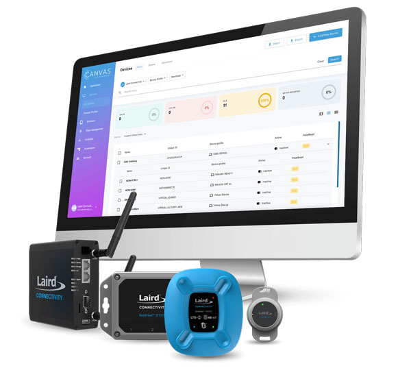
The Canvas Device Manager simplifies workflows for configuration and maintenance of internet of things (IoT) device deployments. It enables users to easily set up devices, monitor performance, and keep software up-to-date across the entire IoT device fleet. Device parameters can be remotely managed, and performance monitored. Canvas enables users to organize large numbers of devices to quickly build and maintain IoT solutions, and software updates can be remotely and rapidly deployed, thwarting security attacks.
The N2 Palm RTK GNSS receiver is suitable for surveying, mapping and construction. It has a highly integrated main board and a three-in-one antenna, yet weighs 0.72 kg with battery and measures 48 mm. Powered by ComNav’s SinoGNSS K8 high-precision module, the N2 can track 1,590 channels, including all existing and planned signals of GPS, BDS-2, BDS-3, GLONASS, Galileo, QZSS and SBAS. Its advanced satellite-tracking technology ensures it works well even in harsh environments, such as under heavy foliage or close to buildings. A third-generation inertial measurement unit (IMU) makes the N2 immune to magnetic disturbance, which greatly improves its reliability. Pole-tilt compensation of up to 60° allows surveyors to locate points within 2.5 cm. By using the company’s Quantum algorithm, the N2 achieves calibration-free operation — after 10 seconds of initialization, users can make tilt measurements with centimeter-level accuracy for an extended period, greatly improving efficiency.
Airbus has added 30-cm Pléiades Neo imagery to its OneAtlas Living Library service. The new data source will complement the service which already allows users to instantly access a premium catalogue of Pléiades 50 cm and SPOT 1.5 m data via streaming, download and API. The Living Library provides frequent updates over urban areas, airports, harbors and military sites to name a few. Imagery is updated every day and processed in the cloud, with flexible options for integration into GIS workflows. With the OneAtlas Living Library, Airbus offers a pay-per-order option but also a subscription-based service that allows users to access premium content quickly available into their account, as well as a deeper archive of more than 10 years of imagery by Pléiades and SPOT satellites at a higher incidence angle and cloud coverage threshold, which will be available in just a few hours. OneAtlas also provides access to several other data services, such as reactive tasking, that allows users to task a full suite of optical and radar satellites, including Pléiades Neo, or access more than 15 years of global radar data, as well as the ability to download the WorldDEM product suite among others.
Free, user-friendly tool shows the Earth’s changes
Photo: Kermap
The Nimbo Maps platform provides monthly 10 m-resolution images of changes on Earth in a user-friendly format. The images are chronological, seamless and free of clouds, and include intuitive comparison timelapse features. The platform, developed by French startup Kermap, relies on innovative artificial intelligence methods to process satellite images supplied by the European Union’s Copernicus program through its Sentinel missions. APIs automatically retrieve data extracted from satellite imagery, providing Kermap customers with real-time, strategic, value-added information in the fields of agriculture, land planning and environmental transitions. Current coverage includes Europe, the Middle East and the United States, with plans to provide global coverage by early 2023.
The TrueView 655/660 3D imaging system uses the Riegl miniVUX-3UAV laser scanner and three fully integrated mapping cameras (right, left and nadir) for high-accuracy mapping with excellent vegetation penetration and wire detection. Previous TrueView 3D systems carried dual oblique cameras to maximize mapping coverage. The TrueView 655/660 adds a third RGB camera, allowing for imagery directly below the sensor to be captured. The third camera provides a direct view of the ground below to maximize data collection for time flown, while improving the quality of photogrammetry and colorized point clouds.
From its humble beginnings in the 1970s to its expanded use in the present day, GPS technology has been vital for nearly every industry from defense and aviation to farming and construction. GPS devices are designed to receive faint GPS signals transmitted from satellites about 12,000 miles away. Acknowledging this reality, regulators have historically maintained for GPS, which relies on such faint radio signals and sensitive equipment, an appropriately quiet spectrum neighborhood—populated by similar users.
With the NASEM report’s confirmation of harmful interference, the deficiencies of the FCC’s April 2020 decision are even more striking
Although these GPS signals and equipment have benefitted from decades of optimization, it is impractical to place highly sensitive GPS receivers designed to capture faint signals from remote transmission facilities immediately next to high-power communications equipment. Unlike those from communications systems, GPS signals are below the thermal noise floor when they are received. As a result, increases in that noise floor often decrease the availability of GPS services, which in turn places at risk high-consequence and safety-of-life services that rely on GPS.
Alex Damato
Why does this matter? In April 2020, the FCC approved a plan to deploy a terrestrial network in spectrum adjacent to the frequency bands used by GPS — operating communications signals that would be around two billion times more powerful than GPS signals at the same location.
This past September, the National Academies of Sciences, Engineering, and Medicine (NASEM) released a report detailing the harmful effects of a terrestrial communications network that would operate in a frequency band close to that of GPS.
Expert concern within 14 federal agencies and departments, a broad coalition in Congress, and the GPS industry resulted in a congressional mandate that NASEM conduct an independent technical review of potential interference to GPS. After a thorough review of the materials, NASEM concluded that the proposed terrestrial network would result in harmful interference to a substantial number of GPS receivers.
In particular, the report noted that high precision GPS devices, which are used in the most economically significant GPS applications, are the most vulnerable receiver class and likely to be affected by interference. The potential for any interference with GPS, especially with devices used by the Department of Defense, poses a threat to national security, the economy, and our daily lives.
With the NASEM report’s confirmation of harmful interference, the deficiencies of the FCC’s April 2020 decision are even more striking: potentially millions of farmers, pilots, construction companies, and first responders may be required to repair or replace GPS equipment at their own cost. Although the FCC assumed that this equipment could be repaired through upgrades or filters, some devices cannot be filtered without significant financial and performance costs, and some devices simply cannot be filtered at all.
GPS is estimated to provide up to $300 billion annually in benefits to the economy. Any disruption in GPS accuracy and usage would have detrimental effects on productivity and economic growth. Moreover, the year before the FCC’s flawed decision, another key report revealed that the loss of GPS service would have an average impact of $1 billion per-day on the nation.
The GPS Innovation Alliance will continue to work with all federal and industry stakeholders to maintain open channels of communication to connect, listen, and learn from all those involved in the discussion. As technological innovation continues, these debates on harmful interference are not going away, and GPSIA is looking forward to engaging further.
What is the most promising approach to increasing the location accuracy of smartphones?
Ismael Colomina
“In addition to the use of increasingly available augmentation services, such as Galileo’s free High-Accuracy Service (HAS), I see two development directions that may help, particularly in the context of positioning in urban areas where smartphones are most used. One is the use of 3D city models — in general, 3D geoinformation — to compensate for multipath, non-line-of-sight and occlusion effects. The other is to use signals that are robust against those effects, which today are only available in geodetic-grade receivers.” — Ismael Colomina, GeoNumerics
For the navigation of autonomous vehicles, will GNSS become essential, or will it be relegated to a secondary role by robotic navigation methods?
John Fischer
“The PNT solution cannot be from a single source because autonomous navigation requires high integrity. Therefore, it’s not that GNSS will be relegated to secondary status, it’s that no one method will be primary. An intelligent fusion of diverse sensors —including GNSS — will provide the PNT solution along with an integrity metric that safeguards operation. The various sensors must agree. If they don’t, no trust can be put into the solution and autonomous navigation will cease. The definition of a new integrity metric that quantifies this trust level is needed.” — John Fischer, Orolia
Ellen Hall
“Because GNSS provides high precision and widely available PNT, it will continue to be a critical component in navigation while working with computer vision, inertial measurement units (IMUs) and lidar through sensor fusion. As a secondary component, GNSS serves a vital role for localization and validation.” — Ellen Hall, Spirent Federal Systems
“Seen & Heard” is a monthly feature of GPS World magazine, traveling the world to capture interesting and unusual news stories involving the GNSS/PNT industry.
Screenshot: Lying in State Queue tracker
Queue Tracker for the Queen
After the passing of Queen Elizabeth II on Sept. 8, the British government launched a live queue tracker app to give people an idea how long they would have to wait to pay their respects at her lying in state at the Palace of Westminster. The app also used What3Words to help locate the end of the line using a three-word tag. The queue grew dramatically in the days before the funeral as tens of thousands lined up, some waiting as long as 16 hours. The app also showed locations of public toilets, drinking water and first-aid stations along the queue route.
Lake Sarez. (Photo: Astronaut Photography Collection/NASA)
A Dam Problem Solved
Lake Sarez, deep in the Pamir mountains of Tajikistan, was created only a century ago when a strong earthquake triggered a massive landslide. The area experiences considerable seismic activity, which could result in massive flooding downstream should a landslide dam break. With the help of 40 donkeys, 10 scientists and 30 staff from the National Time Service Center of the Chinese Academy of Sciences transported and installed a BeiDou-based deformation monitoring system at the dam. The team had to resolve technical problems in the rugged area, such as providing sufficient solar power and communications. With the system now operating, the dam is being monitored in real time down to the millimeter.
Figure 3. (Image: CC BY 4.0, Remote Sensing 14, no. 17: 4274)
Counting the Forest for the Trees
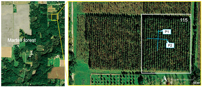
Integration of aerial and ground-based mobile mapping sensors and systems is enabling a team of Purdue digital forestry researchers to locate, count and measure more than a thousand trees in a matter of hours. “The quick, accurate inventory of the global forest ecosystem will improve our ability to prevent forest fires, detect disease, perform accurate carbon counting and make informed forest management decisions,” said Songlin Fei, the Dean’s Remote Sensing Chair. The Purdue-made systems integrate GNSS and inertial navigation devices with lidar and cameras, deployed with manned aircraft, drones and backpack-mounted systems. The technology gathers a variety of information about each tree, including height, trunk diameter and branching formation. The team maintains the precise location and time tags of all acquired features.
Photo: Skeiron
Saving Ukranian Heritage
By the end of May, at least 367 incidences of destruction had occurred to Ukraine’s museums, churches, theaters and libraries. Through the project #SaveUkranianHeritage, mapping company Skeiron is capturing sites in high detail using laser scanning and photogrammetry. For a UNESCO-protected church in Lviv, the team gathered more than 300 individual laser scans and 6,000 photos to create a 3D model. The company has two laser scanners — a Leica C10 and Leica ScanStation P20, DLSR cameras and a drone. To support the project with funding or equipment, visit skeiron.com.ua/en/saveukrainianheritage/.
RNT Foundation President Dana A. Goward was in London last week for a PNT Leadership Seminar. Here is his report.
In March 2021 the United Kingdom’s government told parliament that a national positioning, navigation, and timing (PNT) strategy was to be published imminently.
Yet, in addition to the normal duties of running the world’s sixth largest economy, the last 20 months have been busy for the UK government: evolving issues with Brexit, more COVID, three prime ministers, Russia’s invasion of Ukraine, financial crises… Small wonder that publishing a strategy to address a “not-right-now” concern hasn’t come to the top of the pile.
Royal Institute of Navigation Leadership Seminar
Yet PNT resilience is an incredibly important issue requiring long-term solutions. As a “learned society,” the Royal Institute of Navigation (RIN) has a duty to bring together professional expertise and educate the public on such important topics.
On Nov. 1, the RIN convened a UK PNT Leadership Seminar with “the UK’s leaders in government, industry, academia and key user communities.” Its goals were to not only highlight the economic benefits of resilient PNT leadership for the UK, but also to “develop a view of approaches, priorities and next steps.”
Attendees expressed a wide variety of concerns. These ranged from difficulties growing and retaining talent in the field, to a lack of understanding among the public and government about the essentiality of PNT to virtually every aspect of modern life.
There was general agreement that establishing a coherent and resilient PNT program in Britain would have dual benefits.
First, it would help protect the nation’s economy and national security. Malicious and natural threats to space-based PNT mean that complementary systems are needed to mitigate outages. A government sponsored study in 2017 estimated losses exceeding £5B during a five-day outage. The study’s authors conceded at the event that longer outages would realize much larger per day losses as infrastructure and systems increasingly suffered.
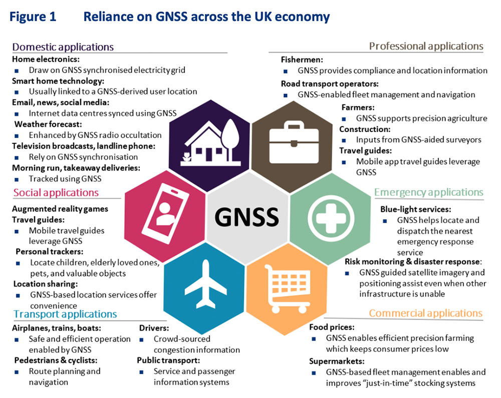
Action to mitigate disruption of space-based PNT was especially important for the UK, according to the concept paper, because “the sectors where the UK has the most value at risk from a loss of GNSS-provided PNT are precisely the sectors that lack adequate resilient backup options.”
Image: London Economics report
Economic Benefits of Resilience
Secondly, British PNT resilience would also have great positive benefit to the economy, especially if the UK established itself as a leader in the field. A concept paper prepared for the seminar by London Economics found that the value chain for the UK would include research and development, provision of PNT infrastructure, PNT module manufacturing, system integration,and application development.
Among the UK stakeholders most likely to benefit, according to the paper, were companies and institutions that were part of the value chain, along with user communities, government and the public overall.
Attendees and the London Economics concept paper agreed that consistent and focused government leadership was essential. Government must create the conditions and confidence to stimulate the whole ecosystem to deliver resilience and the associated economic benefits. In fact, the paper envisioned the government as an “anchor customer” for resilient PNT providers and device manufacturers. This idea echoed that expressed by representatives of PNT providers in the United States earlier this year. The need for government to protect itself with resilient PNT (thus becoming an anchor customer) was a primary theme during a PNT roundtable held by the U.S. Department of Transportation in August.
Getting Government’s Attention
Finding a way to communicate the importance of PNT and UK government leadership in a way that would generate action was another theme from seminar attendees. One panel member despaired the problem was “Little Susie hasn’t died yet.” It is hard to get government’s attention without a disaster of some sort. Another attendee suggested creating a video to increase public awareness thereby causing government to take notice and act.
Finding a high-profile champion was also discussed. An attendee told a story about a member of the royal family’s interest in quantum technologies, how that led to meetings with government, and establishment of the UK’s £1B quantum tech program. While several indicated this isn’t really a path RIN could use, a combination of personal connections or celebrity with the ability to “tell the story” can be very helpful.
Parliament also Concerned
Just three days after the RIN event, the UK government’s leadership of resilient PNT efforts was also formally criticized by Parliament.
It described PNT services as “key enablers of Critical National Infrastructure (CNI) sectors that underpin our national security and defence interests as well as a wide range of other economic activities…”
After reviewing testimony received by the committee the report made several important findings.
Regarding GPS and Galileo:
“The reliance on foreign systems is concerning due to the potential for the UK to be blocked from using them in the future. Reliance on space-based systems is also not advisable as these can be disrupted through jamming attacks or adverse space weather. The loss of PNT services would be detrimental to the UK, with power distribution, financial transactions, and transport systems all seriously affected, and the UK’s national security put at severe risk.”
Commenting on the UK government’s efforts with OneWeb:
“We are concerned that the Government seems to be progressing towards plans to use OneWeb’s low Earth orbit (LEO) satellite constellation to provide PNT services in the future, despite suggestions from experts that there are many technical issues…”
And the Science and Technology Committee is not alone in Parliament being concerned with the nation’s lack of progress on PNT. In its October 2022 report “Defence Space: through adversity to the stars” the House of Commons Defence Committee said:
“Given the vital need for a resilient PNT network both for defence and for other aspects of critical national infrastructure we are deeply concerned by the complacent attitude towards PNT within government, and by the seemingly low priority which the MOD [Ministry of Defense] attaches to this work. Government must publish the conclusions of the SBPP and should set out a clear timetable for producing and taking forward the UK’s PNT strategy in its response to this report.”
‘Move PNT in Government above the Department Level’
Expressing the utmost frustration, last week’s report from the Science and Technology Committee recommended reassigning responsibility for PNT to a higher level of government than where it is positioned now.
The Department for Business, Energy and Industrial Strategy (BEIS) is the ministry currently responsible for publishing and implementing the long-delayed PNT Strategy.
The committee said that this long delay is evidence the ministry is “…refusing to commit to the critical action that needs to be taken.”
It also said:
“…we believe the responsibility for PNT should lie outside of any one department. The Government should establish the National Security Adviser (NSA) as having overall responsibility for the UK’s access to secure PNT capabilities. The NSA should ensure that the importance of developing secure PNT systems is understood throughout Government and take responsibility for developing a programme and budget for the work that needs to be carried out.”
UK Cross-Government PNT Office
For now, there is no evidence the UK government will adopt Parliament’s recommendation to move responsibility for PNT to the National Security Adviser.
However, BEIS has created a cross-government PNT effort to address the nation’s needs. Attendees at the RIN seminar reported that the team is staffed with representatives from several departments, including the MOD.
Seminar attendees said that PNT is getting to be MOD’s highest space-based priority. While not in a position to lead, Defence was strongly supporting cross-government efforts.
Taiwan will launch its first indigenously developed meteorological satellite in March 2023, reports Taiwan News.
The Triton satellite was designed and made by the National Space Organization (NSPO) over eight years. The satellite has completed testing and is undergoing review.
The 250-kg Triton carries GNSS-reflectometry equipment (GNSS-R) — independently developed by NSPO — to collect GNSS signals reflected by the Earth’s surface. Its mission is to research air-sea interaction to help predict typhoons.
Taiwan is hit by typhoons every year. Information on wave height and sea-surface wind speed, retrieved from the reflected signals, will be useful for research on typhoon intensity and path prediction.
The satellite will be transported to the Guiana Space Center in January. It is scheduled to launch in March aboard a Vega C rocket manufactured by Arianespace.