Apple co-founder Steve Wozniak will join Trimble CEO Rob Painter on the stage for the 2022 Trimble Dimensions+ keynote presentation.
Trimble Dimensions+ is a three-day user conference providing education, showcasing innovation and offering networking opportunities with Trimble users, customers and product experts from around the world. This year, the conference will be held in-person for the first time since 2018, and will be held Nov.7-9 at The Venetian in Las Vegas.
Wozniak and Painter to Present
CEO Rob Painter will kick off the conference with an inside look at how Trimble’s Connect & Scale strategy is enabling customers to do their work faster, better, safer, cheaper and greener. Connect & Scale provides innovative solutions to better connect people, technology, tasks, data, processes and industry lifecycles.
Painter will showcase transformative technologies that have had a positive impact on industries, projects and people.
Rob Painter
Painter will be joined on the main stage by Steve Wozniak, who exemplifies Trimble’s passion for innovation and technology. Like Charlie Trimble, the company’s founder, Wozniak began his career in Silicon Valley in the 1970s when he and Steve Jobs formed Apple Computer Inc.. This was was followed by the development of Apple I and II — Apple’s first line of products and integral to launching the personal computer industry.
On the Trimble stage, Wozniak will share his famed journey from computer geek to cult icon, entrepreneur and philanthropist.
The keynote will end with remarks from Aviad Almagor, vice president of Technology Innovation, who will provide a sneak peek at emerging technologies being developed at Trimble — including robotics, autonomy and artificial intelligence — and discuss how they are reshaping the future of engineering and construction.
About Trimble Dimensions
Trimble Dimensions+ user conference is a three-day, in-person event where attendees can better connect as a community for education, inspiration and innovation. The conference provides insight into how Trimble’s industrial technology can transform the way professionals work to succeed and drive sustainability.
Highlights include educational sessions and specialized tracks to advance career objectives, with many sessions qualifying for Professional Development Hour (PDH) credits and Continuing Professional Education (CPE) credits.
The conference includes
the Offsite Experience
hands-on training opportunities
keynote and executive-level presentations
an interactive Expo.
In addition to the in-person event, Dimensions also features the virtual, on-demand Spotlight Series that focuses on industry trends. The series is delivered by experts on technology transforming the way we work.
“Precautionary principle: The principle that the introduction of a new product or process whose ultimate effects are disputed or unknown should be resisted.” — Oxford Languages
Photo: U.S. Fish and Wildlife Service
The Arctic National Wildlife Refuge spans almost 20 million acres. It is home to a vast array of wildlife from tiny pollinating flies to giant grizzly and polar bears.
It also has oil. Lots of oil.
Getting that oil out of the ground and to market would create jobs and benefit commerce. It would also harm the environment. Some wildlife would suffer.
Many argue the long-term harms of drilling outweigh the short-term benefits. The Biden administration agrees and has banned drilling to protect the refuge’s environment and wildlife.
The administration has taken a similarly conservative approach to preserving the spectrum environment for satellites.
Like the previous administration, it has urged the Federal Communications Commission (FCC) to not allow Ligado Networks’ use of frequencies adjacent to spectrum assigned to GPS and Iridium Communications. The concern is that Ligado’s more powerful transmissions will harm some existing users.
A recent report by the National Academies of Sciences, Engineering and Medicine validated that concern. As is the case with many complex environmental issues, the total number of impacted individuals, and the total negative impact to the nation, are unknown. They may be unknowable.
As an independent agency, the FCC gets recommendations from, but does not report to, the administration. To date it has not been swayed by formal appeals from the executive branch, nor by those from numerous industry and non-profit groups, to rescind its decision allowing Ligado to operate.
Like other agencies making environmental decisions, the commission should use the “precautionary principle” when thinking about new uses and users. It is a well-recognized and systematic method of linking science and public policy.
increasing public participation in decision making
shifting the burden of proof to the proponents of an activity
taking preventive action in the face of uncertainty
exploring a wide range of alternatives to possibly harmful actions.
The first three of these were part of the FCC’s process in its Ligado decision, though critics of the outcome might question how rigorously each was applied:
Hundreds of public comments were received before the order was issued.
Critics note that opposition to the FCC’s eventual course of action was expressed by stakeholders across a very a broad spectrum of society.
The applicant, Ligado, was required to bear the burden of proof.
However, as the National Academies report says, different assumptions in Ligado’s analysis led it to an entirely different conclusion from studies done by the Department of Transportation.
The FCC order allowing Ligado to operate includes “preventative actions.”
Yet many see these preventative measures as unworkable window dressing. In the staid and reserved phrasing of the National Academies report, they “may in some cases not be practicable within operationally relevant time and financial parameters.”
Regardless of the virtues or sins of its process to date, the FCC’s path forward must hinge on the final tenant of the precautionary principle: “Exploring a wide range of alternatives in the face of uncertainty.”
The most obvious, simplest, and straightforward of these alternatives is for the FCC to assign Ligado different frequencies, ones more distant from those used by space-based applications.
Admittedly, this path is only “simple and straightforward” in concept. It will require restarting the frequency allocation process nearly from the beginning, detailed analyses, complex negotiations, and difficult decisions.
Yet the current situation means certain harm to an unknown but significant number of GPS and Iridium users. Harm that could, in some instances, be severe. Even life-threatening.
It also means harm for Ligado. As things stand now, the company will always be under a cloud in the minds of federal officials and other GPS and Iridium users. Ligado will also undoubtedly be blamed for a variety of problems not of its doing from solar weather to criminal jamming. And a significant mishap related to company-caused interference could cause it extreme harm. Perhaps even bringing about Ligado’s demise.
The radio frequency spectrum is a limited and critical national resource. The FCC’s desire to use it to best advantage is necessary and appropriate. This, however, requires great care to safeguard the overall environment and existing users.
Resolving the “Ligado issue” will require creativity and a departure from the adversarial approach that has characterized the FCC process to date. Let’s hope that as the commission reconsiders the issue, it finds a way for everyone to come out ahead.
GSG-7 delivers the highest standard of GNSS signal testing in a cost-effective, easy-to-use, turnkey form factor supporting navigation and timing systems
Photo: Orolia
Orolia has released the GSG-7, its latest GNSS signal testing solution.
Orolia made the announcement at the ION GNSS+ conference, taking place this week in Denver.
Offered through the Orolia family of Skydel-based simulators, the GSG-7 features a small form factor, an internal RF combiner, high-end performance with a 1,000-Hz simulation iteration rate, real-time synchronization, hardware-in-the-loop (HIL) integration, powerful automation, and multi-constellation and multi-frequency simulations.
“The GSG-7 is redefining the essential and high capabilities in GNSS simulation with its ease of use, advanced simulation capabilities, reduced size, and competitive price,” said Lisa Perdue, simulation product line director. “Leveraging the powerful Skydel software and commercial-off-the-shelf (COTS) hardware, GSG-7 can accommodate almost any configuration to conduct system testing and simulation. The use of SDRs [software-defined receivers] means that maintenance and customization are not only easier, but more cost-effective than other options on the market.”
Powered by Orolia’s Skydel simulation engine, the GSG-7 can be programmed to simulate operations with all current GNSS signals, as well as future ones. Skydel’s architecture makes the GSG-7 future-proof by allowing new, incoming signals and updates to be implemented through software updates.
The GSG-7 simulator is suitable for development and integration projects that require high performance, all-in-view satellite signals, and an increased number of GNSS constellations.
“Capable of handling complex simulation scenarios, the GSG-7 has a simple, yet powerful application program interface (API) ensuring easy automation and integration into your test environment,” Perdue added. “Users can also benefit from advanced HIL capabilities that include zero-effective latency and built-in performance monitoring tools.”
GSG-7 Webinar
Orolia will host a product webinar on Oct. 6 to discuss the new GSG-7 in great detail. Topics will include:
Transportation Secretary Pete Buttigieg made a surprise appearance at the DOT roundtable on complementary PNT. (Screenshot: DOT)
“If this is a problem, the government should act like it.”
Citing more than 10 years of government studies, warnings and promises, representatives from a wide variety of industries criticized the government recently for doing little to address an important national security problem.
At issue was the need for national backup capabilities for GPS and the essential positioning, navigation, and timing (PNT) signals it provides.
GPS signals are weak and easy to block or imitate. At the same time the signals are used by most technologies including networks, telecommunications, electrical grids, broadcast, mobile radios, transportation, and other critical infrastructures.
After Russia threatened to destroy all GPS satellites in 2021 in its run-up to invading Ukraine, a member of the White House National Security Council told a public meeting “GPS is still a single point of failure” for the nation.
The government was criticized for inaction at a “Complementary PNT Roundtable” hosted by the Department of Transportation (DOT) in early August. The department is the federal lead for civil GPS and PNT issues.
Eight attendees interviewed after the event reported a surprising unanimity of comments and concerns expressed by industry reps at the meeting.
Enough with the studies
A repeated theme was that the government has done enough studies to understand the problem and available technologies.
“They have been studying this for over twenty years,” one attendee observed. “The Volpe [Transportation Systems Center] report came out in 2001. And there have been lots of studies since then. All have just been refinements of those original findings.”
Another consistent theme was disdain for the idea that industry and the free market will solve the problem without government leadership and active support.
“GPS is free,” said one attendee from a company that provides PNT services. “We can and do sell to meet niche demands, but it is laughable to suggest we can ever sell enough subscriptions to be enough of a backup for GPS.”
A major telecommunications company rep echoed the sentiment. Wireless telecom is especially reliant on PNT. “We use GPS and would use Loran and low Earth orbit satellites if they were available, but we are not going to build it on our own. There is just no business case.”
“We have a big list of things we could do that would increase our resilience and/or cut costs,” said another telecom provider. “There is no big driver for most, though. No competitive pressure, no government mandates.”
Government must walk the walk
“The government has been telling us for over a decade that this is a problem,” said one attendee. “If that’s true, why aren’t they acting like it? Transportation is critical infrastructure and needs a GPS backup, for example. So why hasn’t DOT done something?” Of all the criticisms expressed, this was predominant, according to interviewees.
A 2021 Executive Order on responsible use of PNT services encouraged critical infrastructure providers to not rely on GPS.
The government needing to be a lead customer was mentioned a number of times at the event. This would help raise awareness, set an example, and signal to users the issue is important enough to act on.
Government action was also seen by users as key to creating confidence that a technology or service will be around for the long haul. This point seemed to resonate with many of the government representatives as well.
“I am not going to go to the time and expense of adopting something unless I know it is going to be around for 20 years or more. The only way I can be assured of that is if one of the biggest users is the government.”
Adversaries not idle
Of particular concern to some was that America’s adversaries have better, more resilient PNT, and are constantly working against us.
They are building PNT “…systems of systems. Space-based, ground-based, and everything in between-based. They are doing it. We need to get out in front and lead,” said one. China has been particularly active building multiple integrated PNT systems.
“Our adversaries are not stupid” and are going to try to stay in the lead. “They will try to interfere with any frequency, system, or combination of systems selected. We must test and build something that is survivable and resilient.”
“If China, Russia, and Iran had the ability to protect themselves from nuclear attack,” said one attendee, “we would be frantically trying to get the same capability. Yet those countries have backup and complementary systems for PNT, and the United States does not. And we’re not doing anything,” said a participant reflecting upon the event.
Hopeful signs
Several attendees said there were signs the event might not have been “just another government meeting.”
As part of his opening remarks, the event host, DOT Deputy Assistant Secretary Dr. Robert Hampshire, mentioned the bipartisan infrastructure law and affirmed that PNT is infrastructure. This led some to believe funding from the infrastructure legislation could be immediately available if the government decided to act.
Others were cheered by DOT Secretary Buttigieg’s cameo appearance and comments at the event. One remarked it was the first time they had heard a DOT Secretary say “PNT” in over 20 years.
Uncertain outcome
Despite the consistent messaging and potentially hopeful signs, some attendees questioned whether anything would change because of the two-and-a-half-hour event.
“There were about 120 people from industry and a wide variety of government agencies, but what was the point?” asked one. “We all told the government the same things we’ve told them before, often in writing.”
Another was concerned that the event didn’t discuss the most important questions.
“We were talking about individual systems and critical infrastructures,” this person said. “This is a strategic national security issue. We need to get the bullseye off GPS and ensure the United States can’t be blackmailed by having GPS held hostage.”
“And what if there is a major coronal mass ejection? China will come out much better than us because they have survivable PNT. The United States will become a second-rate power to China in an instant. We keep talking about the trees and ignoring the forest!”
One attendee whose company has a very active government relations program reported they hoped the event would help sway those in government still opposed to action.
“It is pretty clear to us that almost everyone in the departments who understand the issues is in favor of doing something as soon as possible. The same with Congress. But even though the National Security Council is worried about this, there are some folks in the Office of Management and Budget who have opposed action for over a decade.”
While some came away buoyed by what they saw as an action-oriented tone to the event, others doubted much would change. “It remains to be seen whether criticism from industry and threats from China and Russia are enough to get the government to finally do something.”
Dana A. Goward is President of the Resilient Navigation and Timing Foundation and serves on the President’s National Space-based Positioning, Navigation, and Timing Advisory Board.
WAAS makes airports without ground-based navigation available to pilots. (Photo: Raytheon)
WAAS monitors and evaluates all GPS signals over North America to enable pilots to fly using augmented GPS data for precision landing and enroute navigation
Raytheon Intelligence & Space, a Raytheon Technologies business, has been awarded a competitive indefinite-delivery, indefinite-quantity contract from the Federal Aviation Administration with a ceiling value of $375 million over the next 10 years.
Task orders, valued at $215 million, were executed at contract award to provide technical refresh and dual-frequency operation (DFO) upgrades to the FAA’s Wide-Area Augmentation System (WAAS) to provide safer air travel in support of the National Airspace System.
WAAS monitors and evaluates all GPS signals over North America to enable pilots to fly using augmented GPS data for safety-of-life missions such as precision landing and enroute navigation. The system allows pilots to safely land in places previously inaccessible because of the airport location or weather. It also makes airports without ground-based navigation available to pilots.
Under the WAAS DFO-2 contract, Raytheon will deliver more modern, and therefore sustainable, processing, system security, and network architecture, while also adding dual-frequency service.
“There is no margin for error during take-off, flight or landing,” said Denis Donohue, president, Surveillance & Network Systems at Raytheon Intelligence & Space. “Our modernization effort for WAAS will improve system robustness during ionospheric events and ensure safety-of-life requirements continue to be met.”
WAAS is a satellite-based augmentation system (SBAS) that provides GPS corrections for critical navigation for the aviation community, first responders and other government agencies, ensuring pilots can land safely in austere environments, despite weather challenges. It also provides corrections for SBAS-capable receivers in use across a diverse set of communities, including agriculture, maritime and surveying, among others.
Raytheon Technologies has been the prime development contractor for WAAS since 1996. Since reaching initial operational capability in 2003, Raytheon and the FAA have developed and fielded dozens of enhancements expanding WAAS’ precision approach capability, coverage area, and reliability, including improvements to the system infrastructure in preparation for dual-frequency service.
WAAS dual-frequency service will enable increased system accuracy, integrity and availability when subject to ionospheric perturbations, including solar storms. Work for this effort is based in Fullerton, California.
Founded in 2012, GeoSLAM is a provider of mobile scanning solutions with proprietary high-productivity simultaneous localization and mapping (SLAM) software to create 3D models for use in digital twin applications.
The addition of GeoSLAM is expected to significantly expand and accelerate Faro’s market growth in the mobile scanning space.
“We are thrilled to add GeoSLAM’s handheld 3D scanning technology to our portfolio of cutting-edge data capture solutions,” said Michael Burger, Faro president and CEO. “Faro now offers the industry’s broadest set of 4D data-capture solutions, including 360° camera-based images, mobile scanning and stationary high-accuracy laser scanning, allowing customers to balance the need for accuracy, speed and detail depending on their requirements. These capture technologies provide the foundation for our 4D digital-reality-based SaaS (software-as-a-service) offering that will allow customers to access multiple 4D data sources for visualization and analysis through a single user experience. We welcome the GeoSLAM team to our Faro family.”
“Joining with Faro represents the next step in the growth of GeoSLAM and the establishment of mobile mapping as a driver for growth in the way businesses map and understand their spaces,” said Andy Parr, GeoSLAM CEO. “Both companies share a vision of the importance of mobile scanning in the burgeoning digital reality capture market.”
GeoSLAM reported £14.5 million in revenue with 18% EBITDA in the fiscal year ending March 31, 2022. EBITDA, a non-GAAP measure, is calculated as net income/loss before interest (income) expense, net, income tax expense (benefit), foreign exchange rate variance, and depreciation and amortization. The transaction closed on Sept. 1, funded with available cash reserves and equity consideration.
Under terms of the agreement, GeoSLAM shareholders received a cash payment of £22.0 million and 495,562 shares of Faro stock subject to customary lock-up provisions. Faro expects the acquisition to be accretive to Non-GAAP EPS in 2023.
Faro serves the markets of architecture, engineering and construction (AEC); facility operations and maintenance; 3D metrology; and public safety analytics.
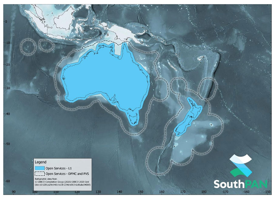
SouthPAN early Open Services coverage. (Image: Geosciences Australia)
The government of Australia has awarded Lockheed Martin a $1.18 billion contract to establish the Southern Positioning Augmentation Network (SouthPAN) to enhance precision.
The system is expected to be fully operational by 2028, and will be provided as a service for 19 years with an option to extend.
The program will use a unique, Lockheed Martin-developed, second-generation satellite-based augmentation system (SBAS) broadcasting on two frequencies to augment signals from two GPS and Galileo.
The SouthPAN initiative
The SouthPAN initiative will deliver a signal augmenting GPS and Galileo over the Australasia region, improving accuracy from 5-10 meters to within as little as 10 centimeters.
The greater positioning accuracy and integrity of the SouthPAN signal has applications across a range of users, including civil aviation, vehicle guidance, precision agriculture for efficiencies in crop management, tracking maritime shipments, and enabling navigation for drones and other unmanned vehicles.
Lockheed Martin Australia will work with the SouthPAN project team to establish a network of GNSS reference stations and satellite uplink facilities that will enable communications and transmissions with the SouthPAN space infrastructure.
SouthPAN is a partnership between Geoscience Australia and Toitū Te Whenua Land Information New Zealand (LINZ) under the Australia New Zealand Science, Research and Innovation Cooperation Agreement.
2017 testbed
Lockheed Martin tested a second-generation SBAS testbed in partnership with Geoscience Australia in 2017.
Lockheed Martin’s second-generation SBAS technology receives and monitors basic signals data from multiple GNSS through widely distributed reference stations. This data is collected by a SBAS testbed master station, which computes corrections and integrity bounds for each GNSS satellite signal, and generates augmentation messages.
The new messages are sent to an SBAS payload hosted aboard an Inmarsat geostationary Earth orbit satellite via an uplink antenna in Uralla, New South Wales. The Inmarsat satellite rebroadcasts the augmentation messages containing corrections and integrity data to the end users’ GNSS receivers. The whole process takes less than six seconds.
Lockheed Martin provided the systems integration expertise in addition to the Uralla radio frequency uplink; GMV-Spain provided its “magicGNSS” processors; Inmarsat provided the navigation payload hosted on the 4F1 geostationary satellite. The Australia and New Zealand Cooperative Research Centre for Spatial Information coordinated the demonstrator SBAS test-bed SBAS test-bed projects.
The SouthPAN contract will expand Lockheed Martin’s investments toward sustainable business growth in Australia. Currently, Lockheed Martin programs support 4,000 Australian jobs in advanced manufacturing and technology industries. The contract will grow that footprint with additional jobs in at least four states.
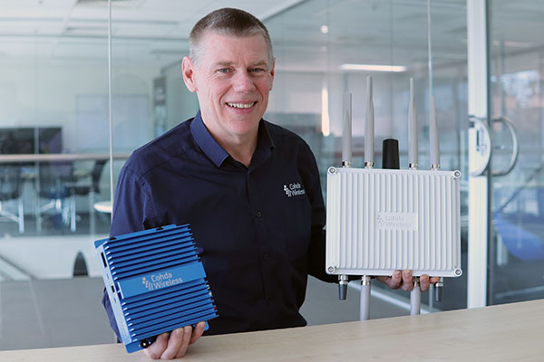
CEO Paul Gray displays the MK6 OBU (left) and RSU. (Photo: Cohda Wireless)
Cohda Wireless has developed an advanced and versatile V2X connectivity solution to help pave the way for the introduction of connected vehicles on smart roads and highways across the globe.
The MK6 RSU (roadside unit) and OBU (onboard unit) offer a comprehensive connectivity capability as standard features, including DSRC, C-V2X, LTE/5G and Wi-Fi/Bluetooth.
The Australian-headquartered company believes the MK6 will expedite the rollout of cooperative intelligent transport systems (C-ITS) around the world. Cohda’s V2X stack and applications are widely deployed in the industry, and the MK6 is the company’s most capable, versatile and powerful platform to date.
The dual concurrent technology capability of the MK6 gives users the reliability, flexibility and interoperability needed to embark on deployments with confidence, no matter where they are in the world, said Paul Gray, Cohda Wireless chief executive officer.
“More and more cities across the world are actively embarking on initiatives to introduce connected vehicles on their roads and we developed the MK6 with the intent that it would become the undisputed connectivity solution of choice,” Gray explained.“City transport authorities want to invest confidently in future-proof products, and when they equip their traffic lights and other roadside infrastructure with the MK6 Road-Side Unit, they are deploying a road-ready solution that can reduce congestion and road accidents.”
The MK6 also offers improved security and processing power for unique and complex applications, Gray said.
In developing the sixth-generation MK6, Cohda applied its experience and involvement in some of the world’s most prolific trials and deployments, including the 3,000-vehicle New York Connected Vehicle Project as well as Australia’s largest connected vehicle pilot, the Ipswich Connected Vehicle Project.
Cohda’s technology has featured in two production vehicle platforms, most recently in 2019 when Volkswagen equipped its Golf 8 production model with Cohda’s V2X. Volkswagen is the second manufacturer to incorporate Cohda’s V2X technology in a production vehicle in readiness for an impending connected road transport system.
“We are approaching a tipping point and we expect the MK6 to be a catalyst for increased momentum,” explained Gray.
“The MK6 is the all-rounder solution that makes it easy for the entire industry, especially cities and transport authorities, to participate in the evolution of the world’s transport systems,” Gray added.
The MK6 features the RoadLink SAF5400 and SXF1800 chipsets from NXP Semiconductors, as well as the Qualcomm Snapdragon Auto 5G Modem-RF Platform. It will be available in December.
From left: Yusuf Kıraç, Türk Telekom chief technology officer, and Net Insight CEO Crister Fritzson. (Photo: Türk Telekom)
Türk Telekom is using specialized GPS/GNSS-independent technology to provide critical time and frequency synchronization in its 5G network.
The technology — developed by Türk Telekom engineers with Net Insight — is expected to significantly reduce synchronization investment costs and increase service continuity in 5G. The companies did not reveal the details of their technology.
Türk Telekom, the pioneer of digital transformation in Türkiye, continues its efforts to shape the future with 5G and new generation technologies. Türk Telekom became the first operator in the world to implement the “Time Synchronization Transmission Solution,” implemented in cooperation with Net Insight, one of the world’s leading technology companies, on its network. This solution, which is the patented technology developed by Türk Telekom and Net Insight, will provide strategic superiority in network technologies.
Minimum end-to-end deviation throughout Turkey
The testing process of the GPS/GNSS-independent stable synchronization service for 5G has been successfully completed. Türk Telekom, which has installed the system at 20 locations in Turkey, will have a central synchronization network with high time accuracy, and will be able to offer synchronization service to 5G base stations.
While the highest time deviation value for 5G is 1,500 nanoseconds, the deviation value was measured at 5–45 nanoseconds in two different regions of Türkiye, according to the first data obtained from the Türk Telekom live network. The values revealed that sensitive time and synchronization information can be carried from Edirne to Hakkari, the entire length of Türkiye, with minimum deviation regardless of network equipment.
Solution to increase efficiency and save resources
“We became the first operator to implement the next-generation synchronization solution, developed together with Net Insight and leveraging patents of Turkish engineers, which is critical for 5G and beyond technologies on the live network,” said Yusuf Kıraç, Türk Telekom chief technology officer. “We see a significant potential in the global market for this innovative solution that will reduce costs and increase service continuity for mobile operators and all industries with critical time synchronization requirements.
“We can meet all these needs with this solution, which has a time deviation far below 1,500 nanosecond required for the synchronization need of 5G,” Kıraç continued. “We are proud to develop new satellite-independent solutions for operators and standardization organizations in the world.”
“We believe that this solution, which is operated on the Türk Telekom network for the first time in the world, will break new ground in 5G and have a high and significant market potential on a global scale,” said Net Insight CEO Crister Fritzson.
Important step for 5G and beyond
The new-generation time synchronization solution, which is not depending on GPS/GNSS satellites, offers unique advantages for transmitting phase and time synchronization over the network without the need to replace or update existing network equipment. With this technology, a fundamental solution to GPS/GNSS satellites’ signal interruptions and service losses — one of the biggest needs of operators who have switched to 5G — will be met, the companies said.
At the same time, the synchronization needs of 6G technologies — planned to begin global standardization studies in 2025 — will be met with the same solution.
The patented technology will be produced and marketed all over the world and will provide solutions for sectors such as telecommunications, energy and finance.
New Combined Program Office to enhance U.S. ability to prevail against threats in space, including new hypersonic weapons
Space Systems Command (SSC) is leading a new tri-agency Combined Program Office (CPO) comprised of representatives from SSC, the Space Development Agency (SDA) and the Missile Defense Agency (MDA). The CPO was established on Aug. 19 to enhance the United States’ ability to deter, defend and win against competitors’ challenges in space.
The Space Acquisition Council, established by Congress to manage space procurements across the Department of Defense, concurred on the CPO proposal, enabling the coordinated development and fielding of capabilities in the missile warning (MW), missile tracking (MT), and missile defense (MD) mission areas.
The CPO will address growing challenges resulting from the transition of space from a peaceful domain to one that is congested, contested and competitive. Other nations now challenge access to and movement in space, and have demonstrated the capability and intent to hold U.S. and allied space assets at risk.
“The MW/MT/MD mission is driving the U.S. Space Force’s new ‘requirements to execution’ roadmap, rapidly turning USSF Force Design into operational capabilities that will outpace and defeat very determined threats,” said U.S. Space Force Col. Brian Denaro, Space Sensing program executive officer and leader of the new CPO. “Our adversaries continue to develop missile technologies that are faster burning, dimmer and more maneuverable. This Combined Program Office, in partnership with SDA and MDA, will drive critical integration across a new resilient multilayer architecture that will warn, track and defeat these increasingly advanced and elusive missile threats.”
Establishing this partnership among MW/MT/MD acquisition organizations will enhance the interface between requirements, operators and users, optimizing delivery of integrated and resilient sensor-to-shooter capabilities for the United States and its allies.
“We are focused on delivering MW/MT/MD capabilities to the warfighter and the nation,” said U.S. Army Lt. Col. Alexander Rasmussen, Tranche 1 Tracking Layer program manager, SDA. “The Combined Program Office is a critical component in delivering this capability and enabling our nation to counter hypersonic and advanced missile threats. Together, SDA, MDA and SSC will ensure a synchronized end-to-end capability that sets the foundation for a continually evolving and advancing MW/MT/MD architecture.”
“With the emerging advanced threats, space-based sensors are essential to missile defense,” said Walter Chai, director for space sensors at MDA. “The close collaboration between SDA, SSC and MDA will ensure that we are able to defeat these threats.”
The CPO organizational structure integrates strategic decision-making across the interagency, establishing:
clear roles, responsibilities, and authorities for SSC, SDA, MDA and other mission partners
end-to-end system of systems accountability between requirements and weapon system delivery
development and management of standards (models, open architecture, data, etc.)
integration with operators, combatant commands and other weapon systems.
Space Systems Command is the U.S. Space Force field command responsible for rapidly identifying, prototyping and fielding resilient space capabilities for joint warfighters. SSC delivers sustainable joint space warfighting capabilities to defend the nation and its allies, while disrupting adversaries in the contested space domain. SSC mission areas include launch acquisition and operations; space domain awareness; positioning, navigation and timing; missile warning; satellite communication; and cross-mission ground, command and control, and data.
Light and with low power consumption, the NavGuard NOCTA Mini is a fully integrated day and night optical navigation module for jam-proof and spoof-proof operations
Photo: Asio Technologies
Asio Technologies has launched the NavGuard NOCTA Mini, a tiny jam-proof aerial optical positioning system for unmanned aerial systems (UAS).
NavGuard is a real-time optical navigation system that enables seamless and accurate autonomous GNSS-free navigation for tactical UAS platforms in areas where the GNSS signal is spoofed, jammed or unavailable. Using machine vision technology, artificial intelligence, advanced optics and sensor fusion, NavGuard can be installed on various unmanned aerial platforms to enable safe and sustainable 24/7 drone missions under complete GNSS blackout.
NavGuard’s new mini version, NOCTA Mini, is suitable for installation on small UAS. Lighter than other NavGuard systems and with low power consumption, it is a fully integrated day and night optical navigation module for jam-proof and spoof-proof operations.
NOCTA Mini enables UAS to operate beyond visual line of sight from takeoff to landing. Because it is based on machine vision, the system is drift-free. The self-contained system incorporates a computing module, geographic information system (GIS) infrastructure, and day and night cameras.
Designed for applications such as defense, homeland security and infrastructure security, it is a suitable solution for tactical UAS missions where payload capacity and flight time are limited, and continuous operation under all conditions is critical.
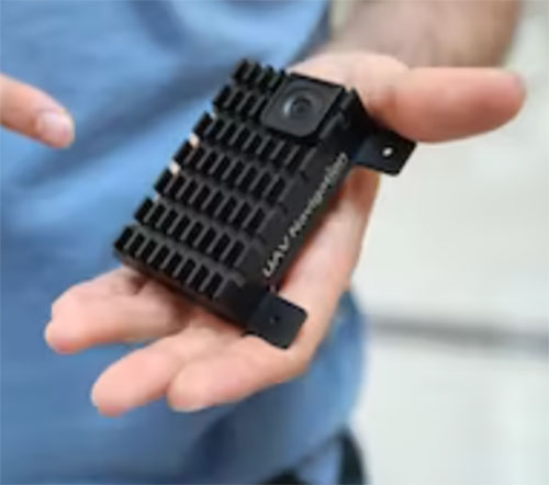
The Visual Navigation System improves navigation in GNSS-denied environments by means of visual odometry techniques
Photo: UAV Navigation
UAV Navigation has released its new Visual Navigation System (VNS), a new capability for manufacturers and end users of NATO Category I and II unmanned aerial systems (UAS).
The compact and lightweight device — provided as an optional peripheral to the main flight control system — enables the safe and efficient navigation of UAVs in GNSS-denied environments. The VNS combines visual odometry techniques and pattern identification with the rest of the sensors onboard the aircraft to ensure that the absolute position, orientation and relative movement of the aircraft over the ground is calculated with extremely high accuracy.
The planning and execution of UAV missions in environments in which the GNSS signal is either unavailable or unreliable is becoming more critical. For some missions, the datalink to the ground control station may be subject to interference, or the operation dictates that the flight must be performed without a datalink from the outset.
Under these circumstances, UAS traditionally rely on an inertial navigation system (INS) to complete the mission. However, all such inertial systems accumulate navigational drift due to sensor noise, propagation models and the difficulty in characterizing external forces. This positional error limits any such UAS operation because an accurate position cannot be guaranteed.
The new VNS, combined with the company’s Vector range of flight control systems, effectively addresses this problem by using data independent from GNSS and more accurate than INS. The system identifies patterns in the terrain below to assist in canceling out any accumulated error, allowing the UAS to operate for long periods without losing positional precision.
Because of its reduced size and weight, the VNS can be installed in Category I and II UAS, enabling them to take advantage of this navigation technique without penalizing autonomy or payload capacity.
The new VNS — developed entirely by the Spanish company UAV Navigation, part of the Oesía Group — has produced outstanding results during flight testing, both on fixed-wing platforms (typically with higher airspeeds and greater service ceilings) and rotary-wing platforms (where high vibrations and hover maneuvers are typically a problem). The new VNS has proved its ability to provide accurate navigation information for flights where there may be an intermittent loss of GNSS signal, and also when a flight must be executed from the outset without GNSS data.