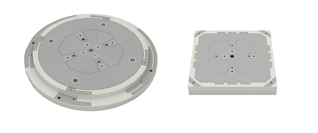
SABIC, a global leader in the chemical industry, has introduced two new LNP Thermocomp compounds that offer the potential to improve signal gain performance compared to ceramics in second-generation automotive GNSS antennas.
The new compounds, LNP Thermocomp ZKC0CXXD and LNP Thermocomp ZKC0DXXD, help enable the design and molding of antenna substrates with more complex pattern markings that add effective surface area, a critical factor in enhancing signal capture.
For customers that use ceramics, switching to the LNP Thermocomp compounds can help lower system costs by avoiding secondary operations, as well as improving antenna performance. Designers and engineers who find current materials inadequate for developing novel, high-resolution GNSS antennas can help address new requirements with the SABIC products, the company said.
“As GNSS antenna technology advances to its second generation with higher resolution, SABIC continues to enhance the scope and capabilities of our LNP specialty compounds portfolio to meet new performance requirements,” said Joshua Chiaw, director of business management, LNP, SABIC. “Our new LNP Thermocomp compounds can help antenna manufacturers achieve superior signal gain compared to ceramic substrates. They also provide flexibility to produce smaller parts with the same performance as ceramic, or equal-size parts with better performance. This remarkable combination of improved signal capture and design freedom, plus system cost advantages, can help propel innovation in GNSS technology — a keystone of occupant safety today and autonomous driving in the future.”
The LNP Thermocomp compounds, which offer a high dielectric constant (Dk) for miniaturization and a low dissipation factor (Df) to facilitate signal acquisition, can be tailored to meet the electrical requirements of individual applications. They feature electroplating capability, good thermal resistance for reliability, and the design freedom and production efficiency of thermoplastics. Both are well-suited for shark fin-style and new conformal antenna designs.
A free 12-day online course on GNSS will be offered by the Indian Institute of Remote Sensing (IIRS), part of the Indian Space Research Organization (ISRO).
“Overview of Global Navigation Satellite System” (Course-ID: 107) will be held Sept. 19-30. The course is designed to help with the urgent demand for trained manpower in remote sensing, geographic information systems (GIS), GNSS and associated geospatial technologies. The course will introduce GPS and GNSS, receivers, processing methods, errors and accuracy.
The course will cover the following topics:
GPS receivers, processing methods, errors and accuracy
satellite-based augmentation systems and GPS-aided and GEO-augmented navigation (GAGAN)
GPS signal characteristics and data formats (broadcast and precise ephemeris)
Indian Regional Navigation Satellite System (IRNSS)
DGPS demonstration
advanced GNSS processing
development of satellite navigation technology, TRANSIT, TSKLON, GNSS (GPS, GLONASS, Galileo and BeiDou), principles of GNSS, segments and applications
satellite navigation.
The course is open to undergraduate and postgraduate students; technical or scientific staff of central or state government; and faculty or researchers at university or institutions.
Course study materials — lecture slides, recorded video lectures, open-source software and handouts of demonstrations — will be made available through the IIRS learning management system E-CLASS.
Vodafone and Topcon Positioning Group are developing a European precise positioning system, Vodafone GNSS Corrections, that will locate Internet of Things (IoT) devices, machinery and vehicles with a greater degree of accuracy than using individual GNSS.
Vehicles, scooters and robotic lawn mowers can be securely monitored in real time to within a few centimeters when connected to Vodafone’s global IoT network.
Vodafone GNSS Corrections will use technology from Topcon, which corrects inaccuracies from navigation satellite signals. Location accuracy is improved from a few meters to centimeters using Topcon’s dense European network of thousands of GNSS reference stations, especially when vehicles and devices are fitted with suitable antennas and receiver equipment.
Vodafone will offer a singular module configuration that can extend across national borders.
Vodafone is inviting select customers to join pilot customer trials in Germany, Spain and the UK, which will begin this month. The companies aim to test the service using a wide variety of devices connected to Vodafone’s global IoT network — one of the largest with more than 150 million connections — and its pan-European network covering 12 countries.
Pinpoint accuracy is critical to the mass adoption of vehicle-to-anything (V2X) technology used for driverless vehicles, autonomous machinery and robots. For example, e-bike riders could use Vodafone GNSS Corrections to provide details of their exact location and then alert other road users of their presence.
Vodafone GNSS Corrections also supports Vodafone’s efforts to improve V2X location accuracy, especially when sharing trusted data to help prevent unnecessary accidents and fatalities on Europe’s roads. As such, Vodafone is offering precise positioning as a complement to Vodafone’s new Safer Transport for Europe Platform (STEP) which allows entities to communicate with each other where no line of sight exists. Unveiled in March 2022, STEP has been successfully tested in Germany and the UK and will be made available via Vodafone Automotive and third-party apps later this year.
Technology changes the rules of the game, and surveying may be more in its crosshairs than the profession will admit
Maps have existed for centuries. The lines on maps indicating the boundaries of political and administrative units — cities, counties, states, and countries — are graphic representations of the limits of those entities. These lines don’t, however, typically exist in real life. There isn’t a large line between the United States and Canada stretching from the Pacific Ocean, through the Great Lakes, and onto the Atlantic Ocean.
The same goes for latitude and longitude lines on maps and globes. The public generally accepts the various delineations on maps as being somewhat accurate with an unwritten level of trust in those who have produced these maps.
Definition
trust: assured reliance on the character, ability, strength, or truth of someone or something.
Here are the guidelines surveyors use for determining surveys.
lines physically verified in the field and proven from evidence
monuments and/or boundaries set and called for within legal descriptions
natural monuments
artificial monuments
adjoiners (to determine junior/senior rights)
courses
bearings, then distances (metes and bounds states)
distances, then bearings (public land survey states)
recitation of area
controlling description
evidentiary description
coordinates: local and/or geodetic
Surveyors rely on physical monuments, title documents and evidence of occupation to assist with the establishment of not just major dividing lines, but all lines of property, public or private. Finding, setting and honoring physical monuments has been a significant character trait of the surveyor for as long as maps have existed.
Monuments are placed to determine the endpoints of these lines as depicted on maps or plats, but what happens when technology introduces new ways to re-establish these lines? What will happen to our monuments when technology — more specifically those who utilize them — deems them obsolete?
The guidelines above are known as “priority of calls” or “rules of construction” by the surveying community. These items have provided the instructions for surveyors to follow in retracement of lines for many years. However, like nearly everything else in our modern world, technology has a hand in modernizing even this time-honored “surveyor’s code of retracement.”
Who would have guessed that the rotary phone dial would give way to touch-tone buttons, that the system would jump from landlines to cellular and satellite signals to remote handsets, then progress to receivers evolving away from physical buttons to touchscreens?
Technology changes the rules of the game, and surveying may be more in its crosshairs than the profession will admit.
Here come the numbers
Note that the last entry in the above guidelines for survey retracement is “coordinates.” In accordance with most accepted lists, coordinates can be local or geodetic. These coordinate values are generated by surveyors, geodesists and public agencies; they can be found on plats, and in records and websites kept by government agencies.
Now that we are more than two decades into the 21st century, it would be safe to say that most of the surveying profession uses an established geodetic coordinate system. The use of GNSS receivers is widely accepted as normal practice by many surveyors because these systems are much more user friendly than in years past. Additional constellations have added to the availability and accuracy of GNSS positional values, so utilizing state plane coordinates has become the norm.
We are now surrounded by something that has an incredible impact on our profession and the world around us. We are placing trust in a georeferenced coordinate system that cannot be identified by any of our senses, like we can with a physical monument.
A coordinate cannot be seen, touched, tasted, heard or smelled.
We are placing our full trust in a reliable position on Earth as determined by our GNSS receiver working within a published coordinate system. Because of these advancements in technology, a new generation of geospatialists is insisting we should revise the way we survey, because technology provides much higher precision and accuracy.
Just like lines on a map or plat, coordinates only exist as a calculation of a position on the face of Earth. So why is there animosity in trusting coordinates over the more traditional items on the list of retracement guidelines? It may have to do with the fact that the ground we are surveying is not in the same place it was a short time ago. Depending on where you live, it may have moved more than you think. For more information on the shifting ground we live on, let us dig into some research about our continents.
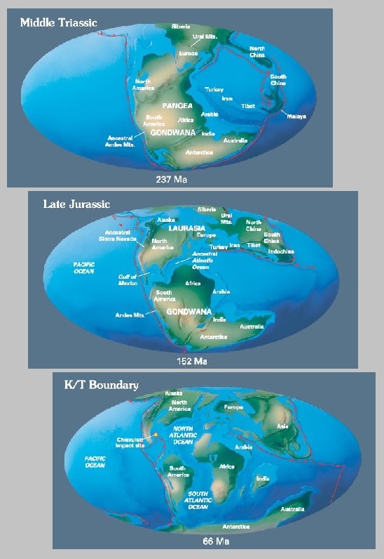
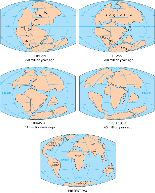
From about 300-200 million years ago (late Paleozoic Era until the very late Triassic), the continent we now know as North America was continuous with Africa, South America and Europe. They all existed as a single continent called Pangea. Pangea first began to be torn apart when a three-pronged fissure grew between Africa, South America and North America. Rifting began as magma welled up through the weakness in the crust, creating a volcanic rift zone. Volcanic eruptions spewed ash and volcanic debris across the landscape as these severed continent-sized fragments of Pangea diverged. The gash between the spreading continents gradually grew to form a new ocean basin, the Atlantic. The rift zone known as the mid-Atlantic ridge continued to provide the raw volcanic materials for the expanding ocean basin.
Meanwhile, North America was slowly pushed westward away from the rift zone. The thick continental crust that made up the new east coast collapsed into a series of down-dropped fault blocks that roughly parallel today’s coastline. At first, the hot, faulted edge of the continent was high and buoyant relative to the new ocean basin. As the edge of North America moved away from the hot rift zone, it began to cool and subside beneath the new Atlantic Ocean. This once-active divergent plate boundary became the passive, trailing edge of westward moving North America. In plate tectonic terms, the Atlantic Plain is known as a classic example of a passive continental margin.
Today, the Mesozoic and Cenozoic sedimentary rock layers that lie beneath much of the coastal plain and fringing continental shelf remain nearly horizontal.
Image: USGS
In geologic terms, a plate is a large, rigid slab of solid rock. The word tectonics comes from the Greek root “to build.” Putting these two words together, we get the term plate tectonics, which refers to how the Earth’s surface is built of plates.
The theory of plate tectonics states that the Earth’s outermost layer is fragmented into a dozen or more large and small plates that are moving relative to one another as they ride atop hotter, more mobile material. Before the advent of plate tectonics, however, some people already believed that the present-day continents were the fragmented pieces of pre-existing larger landmasses (“supercontinents”).
The diagrams below show the break-up of the supercontinent Pangaea (meaning “all lands” in Greek), which figured prominently in the theory of continental drift — the forerunner to the theory of plate tectonics.
Image: USGS
Continental drift, plate tectonics and prime meridians
Historians and other scientists have theorized about Pangea for centuries. Common soil types, fossils, and other evidence found on different continents help to solidify the concept of Pangea. Items discovered on the west coast of Africa have many similarities with those found on eastern South America. The physical evidence is quite convincing that an earlier supercontinent existed millions of years ago.
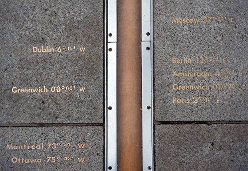
Now, let’s apply a fixed measurement system with lines upon Earth that defines latitude and longitude. In the past, geodesists, geographers and mathematicians established various “prime meridians” around the world to serve as a basis for maps. Locations and cities used included Amsterdam, Antwerp, the Bering Strait, Bern, Brussels, Copenhagen, Florence, Giza, Jerusalem, Kyoto, Lisbon, Madrid, Naples, Oslo, Paris, Philadelphia, Pisa, Rio de Janeiro, Rome, Stockholm, Warsaw and Washington, D.C. (in four different places!), just to name a few.
Thankfully, scientists gathered in the 19th century to agree upon a singular “initial meridian” that would pass through Greenwich, England, and was based upon several centuries of astronomical observations at the nearby Royal Observatory.
For approximately 100 years, mapmakers (and geodesists) used the new Prime Meridian at Greenwich as the beginning baseline for longitude determination around the world. After all, it was based upon years of astronomical observations and solved the age-old problem of where longitude starts. (Latitude was a much easier calculation for astronomers and geodesists, but that story is for another day.)
The late 20th century and the fourth industrial revolution
Technology, once again, provides us with conflicting results. While most technological advancements are game-changing improvements to mankind, they also tend to shake up information and standards that have existed for many generations. Like the previously discussed advancements in telephones, technology makes us change the way we look at things and how we go about our lives.
Mapping has become a central part of our everyday lives. Georeferenced positions for literally everything is now a standard characteristic of many functions within our environment, especially in our surveying world. Most of these improvements are due to GPS, which was originally developed for the U.S. military to guide and assist with positional location of our defense systems in relation to our enemies. We use this same precise technology to establish positional locations for boundary points, infrastructure and topographic information.
Image: Tim Burch
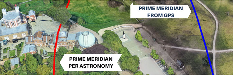
We have also used GPS to learn much about our tectonic plates and varying movement of the continents.The first thing we learned is that the Prime Meridian established in 1884 does not fall in the same place as our 0° latitude designation as determined by GPS/GNSS calculations.
This finding, however, is not the telling item within our adaptation of GPS data; it came when various agencies established the continuously operating reference system (CORS), composed of static GPS base stations. CORS stations, while used to help establish new survey positions in relation to a known reference location, also measure a continuous drift of latitude and longitude positions over time.
The National Geodetic Survey (NGS) is in the process of finalizing a new reference framework for establishing coordinate values that utilize time as a core component. Future implementation of the new National Spatial Reference System (NSRS) will require the additional attribute of time within the metadata of any new values.
So how does this affect surveying and the monuments we surveyors hold on such a high pedestal? The answer varies depending on who one asks. Most surveyors will continue to hold the “priority of calls” as listed above. Several practitioners, however, want to move coordinates higher up the list because of technology, and the ability to retrace a published point because of the increase in technology and the higher accuracy and precision of today’s GNSS.
This is possible if the user of the technology follows the procedures as established by NGS with metadata and accurate timing, but there are still several variables in the setting and retracing methodologies. When was the last time the equipment was calibrated? Was adequate research performed to minimize environmental errors? Was there any interference due to solar storms or multipath? There are many potential issues a surveyor can face, but few are checking all the boxes when performing highly accurate and precise positional measurements.
Technology has brought surveying into the 21st century with GPS/GNSS and ever-increasing accuracy and precision. It should also be the profession’s goal that the technology does not override what the general public can see. They can see monuments, fence lines, buildings and other improvements, but they cannot see coordinates, which remain invisible to the naked eye. Technology may change that in the future, too, but until that time, we must rely on what we can see.
The latest chapter of the decades-long Lightsquared/Ligado saga will be revealed this week
The National Academies of Science, Engineering and Medicine (NASEM) will hold a public online briefing at 11 a.m. ET on Sept. 9 to present the results of its Ligado interference study. The committee’s report will be available at National Academies Press at that same time.
The decision by the Federal Communications Commission (FCC) to grant Ligado Networks permission to operate a terrestrial service in a frequency band adjacent to that used by GPS has been controversial since it was announced in April 2020.
The Executive Branch has formally objected to the decision because of its potential to interfere with various kinds of GPS receivers and requested its reversal. So have numerous industry groups.
The satellite communications company Iridium and some weather organizations also formally objected.
Seven different “Petitions for Reconsideration” were filed with the FCC in May 2020 reflecting a variety of engineering- and process-based objections. None have been acted upon and all are still open issues for the commission.
As a result of the long dispute over the potential for interference, the National Defense Authorization Act for 2021 required the Department of Defense (DOD) to contract with NASEM to examine the issue. The study effort began almost exactly a year ago with the announcement of a proposed study team.
According to the NAESM website:
This study will review Federal Communications Commission order FCC 20-48, which authorized Ligado Networks LLC to operate a low-power terrestrial radio network adjacent to the Global Positioning System (GPS) frequency band. It will consider how best to evaluate harmful interference to civilian and defense users of GPS, the potential for harmful interference to GPS users and DOD activities, and the effectiveness and feasibility of the mitigation measures proposed in the FCC order.
Specific results were intended to include:
which of the two prevailing proposed approaches to evaluating harmful interference concerns — one based on a signal-to-noise interference protection criterion and the other based on a device-by-device measurement of the GPS position error — most effectively mitigates risks of harmful interference with GPS services and DOD operations and activities
the potential for harmful interference from the proposed Ligado network to mobile satellite services — including GPS and other commercial or DOD services, and including the potential to affect DOD operations and activities
the feasibility, practicality and effectiveness of the mitigation measures proposed in the FCC order with respect to DOD devices, operations and activities.
Other relevant issues the study committee found are also expected to be discussed.
The NASEM committee has been meeting regularly since the end of September 2021 and has heard from numerous industry and interest groups on both sides of the issue. Materials presented as well as videos of the public portions of all the meetings are available at the group’s website.
Both a classified and an unclassified version of the report are supposed to be produced. No information has been released about whether the classified report has been completed and provided to the Department of Defense.
Based on previous NASEM reports, some observers predict the results of the study will not strongly support either side of the dispute. “Most of these kind of reports say, ‘On the one hand this, but on the other hand that.’ Usually they are not really conclusive. I expect both sides will find something in it to support their assertions and the dispute will continue as it has to date,” said one stakeholder.
Project GENIE (GNSS Excluded Navigation Intelligent Enhancement) will mature and advance non-GNSS solutions as part of a long-term objective to enable assured location and navigation in commercial aerospace, helping to unlock the benefits and value of autonomy in civil aviation. The support from NATEP will enable the consortium to take a significant step toward navigation in GNSS-spoofed or -denied environments, the companies said.
“Tomorrow, as we look towards single-pilot operation and future autonomous aircraft, there will not be a pilot or air traffic controller available to mitigate these risks,” stated the companies in a press release. “GENIE has been developed to step into this role. It will be able to identify when a GPS signal has been compromised and, using a combination of techniques, provide a location position as accurate as GPS.”
“The need to provide assured, resilient navigation is a critical enabler for autonomy in the aerospace environment,” said Charles Smith, CCO at Archangel Imaging. “GENIE is a core element of this, and we are very excited to be working with NATEP to help push this technology forward. We see significant commercial exploitation opportunities as a result of this project in the UAV and broader aviation markets and are thrilled to be a part of this round of NATEP funding and support.”
Trimble is committing to reduce greenhouse gas emissions in line with the ambitious goals of the Paris Agreement and a net-zero future to keep global temperature increase to 1.5° C.
“Taking decisive climate action is essential to protect our planet and communities for future generations,” said Rob Painter, president and CEO, Trimble. “It also demonstrates Trimble’s commitment to our purpose — to transform the way the world works as well as transform the way ‘we’ work.”
“For decades, Trimble solutions have contributed to reducing greenhouse gas emissions and combating climate change,” Painter said. “The nature of Trimble’s technologies, which connect the physical and digital worlds, provides efficiencies and promotes sustainability in our end markets such as construction, agriculture, forestry, utilities and transportation. Our leadership team is committed to further reducing our carbon footprint as well as continuing to develop solutions that enable our customers to reduce their climate impacts — it is an important lever in our Connect and Scale strategy. Trimble is dedicated to do its part to help protect and build a better world.”
Trimble’s science-based targets accelerate decarbonization across its value chain, and include the following commitments:
reduce absolute scope 1 and 2 greenhouse gas emissions by 50 percent by 2030 from a 2019 base year
achieve 100 percent annual sourcing of renewable electricity by 2025
reduce absolute scope 3 greenhouse gas emissions from fuel and energy-related activities, business travel and upstream transportation and distribution by 50 percent by 2030 from a 2019 base year
commit to partner with 70 percent of its suppliers by emissions covering purchased goods and services and capital goods to set science-based targets by 2026.
“Setting ambitious yet achievable climate targets is part of our commitment to reducing Trimble’s carbon footprint,” said Leah Lambertson, senior vice president and head of Sustainability, Trimble. “Embedding our climate action goals into Trimble’s operational choices will help ensure that our decision making and growth plans are consistent with our low-carbon vision. Today’s commitments are important steps in our journey to delivering growth in a responsible and sustainable way to achieve a net-zero future.”
Trimble’s 2021 Sustainability Report
Trimble also announced the release of its 2021 Sustainability Report. Built around the company’s mission of transforming the way the world works, the report describes how Trimble is helping to create a better future for the planet and the communities it serves.
The report summarizes its initiatives and performance across environmental, social and governance (ESG) topics, highlighting the company’s sustainability approach; end-user industry solutions; community philanthropy through its Trimble Foundation Fund; employee engagement and development as well as diversity, equity and inclusion (DEI) initiatives; and governance.
GNSS researchers are presenting hundreds of papers at the 2022 Institute of Navigation (ION) GNSS+ conference, taking place Sept. 19–23 in Denver, Colorado, and virtually. The following five papers focus on GNSS receiver technology and interference mitigation. The papers will be available at www.ion.org/publications/browse.cfm.
The growing dependence of critical and safety-of-life systems on GNSS makes the ability to rapidly detect and localize the presence of GNSS interference events increasingly important. Ground-based GNSS jammer detection can be used to detect local interference sources. However, this approach is limited by line of sight, hence applying it to large areas is costly in both time and money.
A complementary technique is to use the airborne GNSS receiver data provided by Automatic Dependent Surveillance—Broadcast (ADS-B). As these receivers are at altitude, their lines of sight can cover a wide area. The drawback is that ADS-B was not designed for this purpose, and the messages contain limited information for the assessment of interference.
The authors have developed and will demonstrate an algorithm for real-time detection and localization of GNSS interference sources using ADS-B transmissions on the 1090 MHz (Mode S ES) radio frequency channel. They demonstrate this capability using recorded ADS-B transmissions from known interference events.
Zixi Liu, Sherman Lo, Todd Walter, Juan Blanch, Stanford University; “Real-time Detection and Localization of GNSS Interference Source.”
Even interference at low levels can be catastrophic to systems that depend on GNSS. It can prevent GNSS signals from reaching the user (interference or jamming) or give false signals, resulting in an incorrect position and time solution (spoofing). The capability to confidently detect and localize interference quickly could help mitigate this threat. Furthermore, if the system could also provide information characterizing the interference, it could help law enforcement not only interdict, but also prosecute the threat.
Building a consumer-level commercial-off-the-shelf (COTS) GNSS monitor would also make it cost effective for widespread utilization. This paper describes the development and field testing of a system to provide this capability.
The monitor uses the u-blox F9, an inexpensive commercial receiver offering multi-constellation and dual-frequency position and time solutions, as well as powerful interference-detection metrics. Initial analysis of the receiver’s measurement capabilities determined that it provides many features useful for assessing the operational environment across a geographical region. Performance and output of the receiver is characterized under different jamming and spoofing scenarios.
Different receivers and antennas may react differently based on both hardware and software configurations and offer the user varying interference rejection techniques and detection metrics. As a result, it is important to gain a good understanding of the receiver’s behavior. Another way to test behavior is to examine its performance in nominal conditions in various scenarios and locations, as presented in this paper.
Benon Gattis, Dennis Akos, University of Colorado Boulder; Yu-Hsuan Chen, Sherman Lo, Todd Walter, Stanford University; “Test and Measurements from a Global Navigation Satellite System (GNSS) Monitoring System.”
GEOLOCATING INTERFERENCE WITH SMARTPHONES
Conference Presentation: Virtual; Session F6
With the availability of RAW GNSS measurements on Android smartphones, detecting GNSS interference using modern handsets has become a realistic crowdsourcing possibility, especially with the inclusion of automatic gain control (AGC) in Android 8 (Oreo).
While crowdsourcing jamming detection — and knowing whether your smartphone is subject to jamming or spoofing — is valuable, locating the interference source may be even more important. This work explores the feasibility of crowdsourcing interference source localization with modern Android smartphones.
The work has three goals:
To examine localization of a civilian-type GPS L1 jammer using a network of smartphones
To investigate how best to approach current obstacles regarding such localization
To estimate how accurate this type of positioning can be.
An important part of this work is to investigate differences in GNSS data reported by various Android smartphones. The smartphones in this study were specifically selected by the manufacturer of the GNSS chipset to enable the authors to examine how their GNSS receivers perform under the same circumstances. Three parameters were specifically investigated as measures of received jamming power: carrier-to-noise ratio (C/N0), AGC and the number of tracked satellites.
The selected smartphones were put through a series of tests to examine how these three parameters vary with changing conditions. These tests include subjecting the smartphones to an actual jammer in a controlled lab setup and an investigation of the impact of smartphone (GNSS antenna) position and orientation on C/N0 and AGC. Using the data collected in these tests, several interference geolocation strategies will be discussed.
The authors also consider whether interference localization from consumer-off-the-shelf (COTS) smartphones is currently accurate enough for this use. The shortcomings of smartphone GNSS hardware may be resolved using more clever positioning strategies such as using a larger number of handsets. Alternatively, it may require upgraded hardware and standardization.
Søren Skaarup Larsen, Daniel Haugård Olesen, Anna B. O. Jensen, Lars Stenseng, Technical University of Denmark, DTU Space; “Assessment of RFI Geolocation Using Modern Android Smartphones.”
Multipath mitigation with machine learning relies on offline training with an exhaustive number of labeled observations. Current super-resolution correlation methods, which include MUltiple SIgnal Classification (MUSIC), operate online by testing and choosing from a high number of candidate signal hypotheses.
A new method of MUSIC is presented that reduces numerical complexity and is applied to processing L5 correlation vectors to reduce multipath by identifying the earliest path. The rank of this estimator is examined in static and dynamic conditions in various signal environments. Higher rank allows more signal paths to be identified.
This method is also complementary with various L5 signal-tracking methods such as open- and closed-loop tracking.
Paul McBurney, Norman Krasner, Florean Curticapean, Miguel Ribot, Mahdi Maaref and Lionel Garin, OneNav; “Application of Super Resolution Correlation to Multipath Mitigation in an L5 Channel.”
One of the simplest ways to increase GNSS anti-jamming and anti-spoofing (AJ/AS) performance is increasing the number of controlled reception pattern antenna (CRPA) array elements. However, this increases the size, cost, complexity and required processing power of the overall system. To counter this constraint, the researchers applied a new development in antenna hardware design to GNSS threat mitigation techniques. This resulted in better CRPA performance without increasing the footprint. The work improves AJ/AS performance without adding additional elements, and serves as proof of concept of the application of an adaptively spaced virtual array created with multimodal elements to GNSS AJ/AS.
New breakthroughs in antenna-array research extend the case of non-uniform excitation of elements to the elements’ individual positions. By using multimodal antennas as elements, it has been shown that elements’ phase centers, or perceived locations, can be adjusted with purely electronic means. When applied to each element in an antenna array, this realizes a reconfigurable array.
This research extends the concept of a virtual array with adaptive inter-element spacing into GNSS AJ/AJ methods. A new way to integrate a virtual array into a GNSS application is explored and incorporated into current space-time adaptive processing (STAP) algorithms.
Gabriel Wiggins and Scott Martin, Auburn University; “Applications of a Virtual Antenna Array to GNSS Threat Mitigation: First Results.”
By Nino De Falcis, Senior Director of Business Development, ADVA
Today’s critical network infrastructure is heavily reliant on positioning, navigation and timing (PNT) services. Power grids, financial markets, transportation, data centers, communications — all have become more complex and interconnected, while the threats to the PNT on which they depend have grown in frequency and sophistication. PNT systems are so vulnerable to the activities of cybercriminals that attacks may soon become global in scale and significance, with potential costs of billions of dollars.
Utilities are a key example of infrastructure at risk. In the past, power networks were passive systems with everything simple and centralized, and with energy flowing in one direction only as AC power was provided to consumers. However, the growth in renewables and distributed energy resources has spurred diversification of the market, and a new paradigm of bidirectional AD and DC energy production and distribution has emerged: the smart grid.
Timing Challenges
Today, many smaller producers are generating power from multiple sources. The power grid has become a decentralized system and the flow of energy is now bidirectional. Energy from solar panels (microgrids), for example, can be generated by private individuals and either stored or fed back into the grid. Electric vehicles (EVs) are also becoming more common, and like all other nodes across the smart grid, charging points require precise timestamping of the massive amount of data they generate to balance power demand and supply.
Precise timing is also key to rerouting power flows away from transmission outages, to locating power line faults, and for synchronizing distributed control and protection systems. Without highly accurate timing and synchronization, power grids are vulnerable to partial outages and even complete blackouts.
That is why accuracy requirements of data timestamping are tighter than ever. In fact, they are shifting from legacy Network Timing Protocol (NTP) timestamping, which has millisecond accuracy needs, to Precision Timing Protocol (PTP) timestamping, requiring sub-microsecond accuracy. The syncrophaser now demands accuracy better than 1 microsecond.
For fault location, we’re now at 100 nanoseconds. The micro-phasor measurement unit (PMU) is at less than 1 microsecond and substation LAN communication protocols have to be time-stamped at as low as 100 microseconds for GOOSE IEC 61850 and at 1 microsecond for IEC 61850 sample values. This is a big change from just five years ago when accuracy in all these categories was firmly in the millisecond range, and it’s a high bar that needs to be maintained by next-generation redundant systems, should GPS or ground-based timing become compromised.
Guidelines for making PNT infrastructure fully redundant are being pushed by governments across the world. In the United States, regulations are being driven by Executive Order 13905 with the Department of Homeland Security (DHS) providing a framework for how assured PNT (aPNT) should operate. It states that PNT infrastructure must perform three core functions: prevent, respond and recover. Infrastructure must have the ability to prevent atypical PNT errors and corruption of PNT sources. If prevention fails, networks must be able to respond to detected errors or anomalies and then recover from those errors.
The DHS framework outlines four resiliency levels. Level 1 has only one source providing PNT, while level 4 is a next-generation system leveraging multiple sources to derive and distribute PNT data. At Level 4, systems need to be self-survivable. This means they must function for long periods in the absence of a GPS timing source, or when ground-based timing sources have been otherwise compromised. There is even an IEEE P1952 resilient PNT standard in progress that will use this DHS framework.
Rising Threats
There are two categories of threat to PNT: external and internal. External threats include jamming (equipment that can block GPS is available off the shelf for as little as $20) and spoofing, which is the act of transmitting false GPS signals that trick receivers into calculating an erroneous position. Sophisticated cyberattacks can be in the form of either of these and spoofing (especially synchronous) is the most complex to detect.
The two main internal PNT threats come from attacks on NTP and PTP network timing as well as active GPS receivers connected to the network.
Legacy power grids have traditionally used NTP to distribute timing to substations, including IRIG, and this has already shown itself to be vulnerable to attack because it can be hacked by a process called NTP amplification.
Today, power grids are increasingly migrating to PTP because it provides the sub-microsecond accuracy needed for modern applications. PTP also has not yet been hacked, but that does not mean it soon will not be. If an attack did occur on ill-prepared critical infrastructure, the results could be catastrophic.
Secure Smart Grid Timing Components
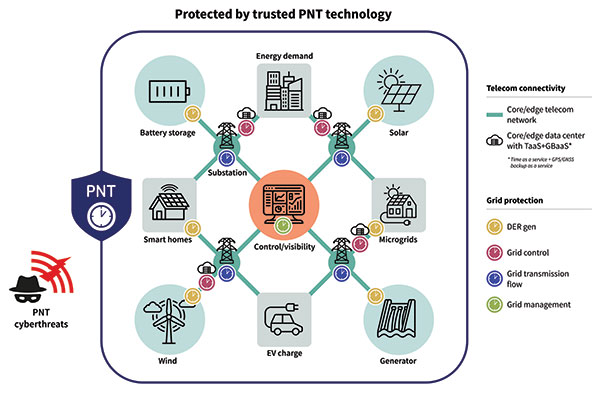
There are two components in the smart grid: telecom connectivity to transport data, and grid protection that has different level generation grid control, transmission and management. On the telecom side, there is the edge telecom network and sometimes there are data centers. There are either core or edge data centers and these are also equipped with very good timing. A key concept in the data center is time as a service and GPS backup as a service when GPS goes down. The smart grid can also leverage this service as it gives even more robust protection and security against threats to PNT. See Diagram 1.
Diagram 1. A key concept in the data center is time as a service. (Image: ADVA)
A Resilient and Assured PNT Solution
As with other aspects of cybersecurity strategy, smart grids must employ a zero-trust framework of PNT sources. This approach never assumes that any one PNT source can be trusted. Instead, it uses a multi-source approach, verifying sources and comparing them to each other in real time to get the most accurate timing possible.
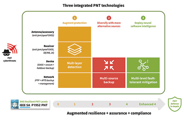
To prevent and mitigate interruptions to GPS, smart grid operators should deploy a resilient and assured PNT solution. This means it’s based around three integrated technologies: multi-layer detection, multi-source backup and multi-level fault-tolerant mitigation.
Multi-layer detection is performed through timing devices – either single or redundant – that have jamming and spoofing detection and monitoring capabilities. GNSS devices are also capable of comparing sources such as network PTP timing and they can be equipped with standalone, GNSS-backup clocks that leverage rubidium or cesium oscillators to obtain the most reliable timing information from other timing sources in the network.
Multi-source backup comes in the form of a cesium or rubidium oscillator that can provide extended holdover. Backup can be further bolstered with other sources such as eLORAN, NIST and LEO.
A neural network management system is an intelligent platform that ties everything together, from self-actionable recovery and assurance software to alerting users of issues in the network-wide timing infrastructure. It provides visibility and control of all aspects of prevention, mitigation and backup. The management system gives detailed operational data on the smart grid, showing the locations of the faults, the types of faults, and how PTP backup assurance is performing. Through capabilities powered by artificial intelligence and machine learning, the management and control system provides the end-to-end control, visibility, and trusted, assured PNT. It has all the intelligence to reveal threats and also take action against them, quickly recovering the network’s timing distribution capability, while keeping the network timing self-survivable. See Diagram 2.
Mitigating Cyberattacks with a Defense-in-Depth Approach
So, let us imagine there is a major attack on a smart grid. A jamming device has been used to block GPS reception on an edge grandmaster being used at a substation, while at the core of the network an ePRTC’s ability to receive GNSS signals has also been compromised. GPS is no longer viable as a source for timing in the smart grid.
The intelligent software monitoring and management system is the first line of defense, detecting and alerting operators to the two or more attacks on GPS: one at the core of the network and one at the substation. The network timing capability of the whole smart grid has been compromised.
Upstream from the substation, the core enhanced PRTC (ePRTC) has become an unreliable source of timing. However, it is equipped with a cesium clock that steps in to propagate trusted PNT backup into the substation and throughout the rest of the network. The cesium clock has no antenna, no RH signal, and is a stratum 1 clock that can propagate highly accurate timing (accurate to 1 microsecond over four months) throughout the network. It has now become the trusted source of timing until GPS can be re-established.
The most crucial element of PNT is timing. Without timing there is no positioning or navigation — it is the enabler of both — and so the distribution of accurate timing must be our top concern when we build systems.
For smart grids and all other critical infrastructure dependent on PNT to function, the cornerstone for secure and self-survivable timing networks is the concept of zero-trust. A multi-source approach to building timing networks will allow operators of critical infrastructure to leverage a combination of intelligent management software and timing devices equipped with adequate PTP holdover to respond to all threats to PNT.
To see a real-world example of this approach in action, check out the DOE DarkNet program.
“Seen & Heard” is a monthly feature of GPS World magazine, traveling the world to capture interesting and unusual news stories involving the GNSS/PNT industry.
3D mapping is helping forensic teams reconstruct fatal traffic accidents in Singapore, reports The Straits Times. In 2021, Singapore had 100 fatal road accidents. Experts use 3D replicas of the accident site and simulation models to recreate events leading to an accident and its aftermath. This helps forensic scientists determine whether the vehicles were speeding or flouting traffic rules. The National 3D Mapping Program of the Singapore Land Authority has mapped every road, lane and highway in Singapore with a 3D laser scanner and car-mounted cameras, and plans to update the maps regularly. Autonomous vehicles will also depend on the 3D point-cloud data.
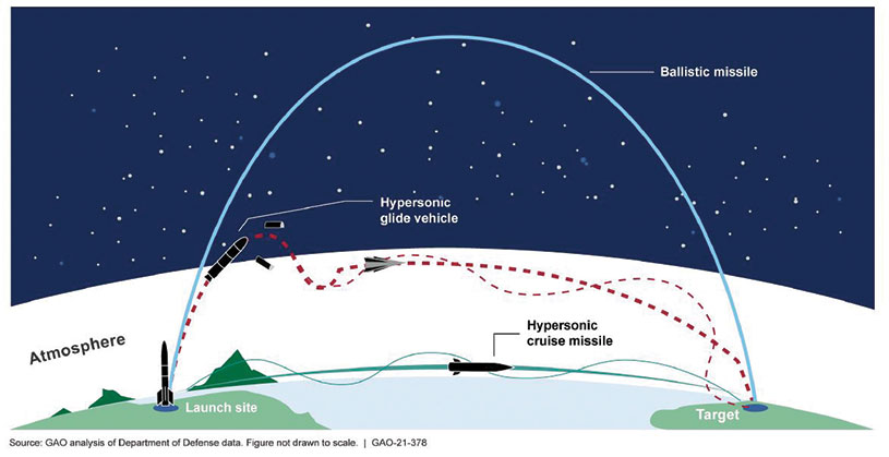
Diagram: U.S. General Accountability Office
BeiDou Enables Hypersonic Flight
In simulation drills using BeiDou, Chinese space scientists flew a hypersonic flight from Jinan, China, to New York over the Arctic Ocean, reports EurAsian Times. BeiDou facilitated contact between the command center on Earth and the hypersonic vehicle as it dodged enemy air defenses. Researchers claim using BeiDou provided a time lag of less than a second. They also claim to have optimized signal transmitters and designed new satellite-jumping methods to overcome communication challenges. China and Russia are the only countries with operational hypersonic weapons — Russia has used its Kinzhal hypersonic missile in the Ukraine war.
Indonesia’s National Research and Innovation Agency (BRIN) and Dr. Soetomo University are cooperating on aerial photo mapping using an unmanned aerial vehicle and GNSS hardware. BRIN’s Ocky Karna Radjasa said he expects that the two parties will extend the opportunity to advance research and innovation as well as bolster the quality of education in Indonesia. The university’s Nur Saidah expects BRIN’s support will increase, stating, “We still have limitation in laboratory facilities, so we seek industry cooperation. Let us hope that, as a result of this cooperation, we can receive help.”
A new navigation system addresses shortcomings of GNSS using cosmic-ray muons. Muometric navigation enables positioning underground, indoors or underwater within a reference coordinate system defined by the 3D positions of multiple detectors, researcher Hiroyuki K. M. Tanaka explains in the June issue of Nature. Tanaka’s work shows the system offers a navigation quality almost equivalent to aboveground GPS-based handheld navigation by determining the distance between the reference frame and the receivers with a precision of 1 to 10 meters.
ComNav Technology Ltd. has released the N2 Palm RTK GNSS receiver. The release coincides with the company’s 10th anniversary. With its advanced technologies, the N2 is suitable for surveying, mapping and construction.
The N2 has a highly integrated main board and a three-in-one antenna, yet is extremely thin and portable, weighing about the same as a basketball (0.72 kg with battery) and measuring 48 mm, the thickness of AirPods.
Powered by ComNav’s SinoGNSS K8 high-precision module, the N2 can track 1,590 channels, including all existing and planned signals of GPS, BDS-2, BDS-3, GLONASS, Galileo, QZSS and SBAS. Its advanced satellite-tracking technology ensures it works well even in harsh environments, such as under heavy foliage or close to buildings.
A third-generation inertial measurement unit (IMU) makes the N2 immune to magnetic disturbance, which greatly improves its reliability. Pole-tilt compensation of up to 60° allows surveyors to locate difficult points precisely and easily while maintaining positioning accuracy within 2.5 cm. By using the company’s Quantum algorithm, the N2 achieves calibration-free operation — after 10 seconds of initialization, users can make tilt measurements with centimeter-level accuracy for an extended period, greatly improving efficiency.
With its integrated UHF modem, the N2 can reach a working range of up to 15 km. It can be used as either a base station or a rover.
The N2 features a 10,000 mAh intelligent Li-ion battery, along with ComNav’s patented low-power-consumption technology. It fully charges in five hours and works continuously in the field for 20 hours. The built-in USB-C port makes it convenient to charge with standard smartphone chargers or external power banks.
As with ComNav’s other products, the N2 meets ComNav’s high quality and durability standards; it is rated IP67 (dustproof and waterproof) and can work in temperatures from –35° C to +65° C. It can be used in a wider range of outdoor working conditions.
With near-field communication (NFC), the N2 can connect to other NFC-enabled devices, such as the R60 data collector. V5.0 dual-mode Bluetooth inside allows users to connect at ultra-long distances with low energy requirements.
The N2 Palm RTK GNSS receiver now is available through ComNav Technology authorized local distributors or directly from ComNav Technology.
Compared to the other three GNSS constellations, what is currently the greatest strength of GPS? What is its greatest weakness?
Bernard Gruber
“I would submit that the greatest strength of GPS is its ubiquity. GPS really is everywhere — worldwide and accepted. It is a trusted and free continuous source, backed by the integrity of the United States, and used for location, navigation, tracking, mapping and timing in myriad applications. Spawned and integrated applications that rely on GPS are well into the high billions of dollars! As they say, ‘When you’re on top, people will be gunning for you.’ In the case of GPS, I would offer that that is its greatest weakness — overreliance without a backup for those users that should have one.”
— Bernard Gruber, Northrop Grumman
Jules McNeff
“I’ll second Bernie’s comments and add that the nearly universal trust in GPS, despite the protestations that it is operated by the military, is a result of decades of openness regarding its operation and improvement. Rare faults are acknowledged and repaired, and planned civil modernizations, though sometimes delayed, are developed with civil collaboration and are fully and publicly documented. Its success and consistency have made it a target, which would be a significant weakness but for a growing awareness of the need for complementary PNT sources to sustain the value it has created.”
— Jules McNeff, Overlook Systems Technologies
F. Michael Swiek
“On strengths, it is very simple: reliability, consistency, stability and transparency.”