Service providers harnessing the solution can now offer GNSS/GPS- backup-as-a-service (GBaaS) with enhanced precision and availability
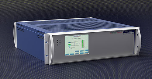
OSA 3300-HP. (Photo: ADVA)
ADVA has introduced its Oscilloquartz high-performance optical cesium atomic clock. The coreSync OSA 3300-HP is ADVA’s latest innovation in assured positioning, navigation and timing (PNT).
Following ADVA’s launch of an optical pumping timing solution two years ago, the OSA 3350 ePRC+, the OSA 3300-HP takes the technology to new levels. It has a 10-year lifetime compared to the five years offered by currently available high-performance magnetic clocks.
As a high-performance optical cesium clock, the OSA 3300-HP sets a new benchmark for precision and availability, ADVA claimed, providing the resilience required for PNT assurance in critical infrastructure and empowering service providers to deliver differentiated service-level-agreement timing offerings with integrated GNSS backup.
The feature-rich device has embedded Ethernet- and IP-based management as well as a user-friendly touchscreen graphical user interface.
“The launch of our coreSync OSA 3300-HP marks a key milestone in the design of atomic frequency and phase standards,” said Gil Biran, GM of Oscilloquartz, ADVA. “After many years of extensive work in our Swiss laboratories supported by the European Space Agency, we now have a mature, state-of-the-art technology that enables a major leap in the accuracy and stability of network timing while providing a substantially longer lifetime.”
Atomic clocks offer synchronization backup for networks that rely on GNSS-based timing, combining high accuracy with outstanding availability. The OSA 3300-HP commercial high-performance optical cesium atomic clock features an all-digital design and leverages optical-pumping techniques using laser diodes. This enables it to measure 100 times the number of atoms, making it more efficient compared to existing primary reference clock (PRC) technologies.
The satellite company spoke to 20,000 people in 11 countries across the globe to uncover their perceptions of space, what happens “up there” and how they think it impacts life here on Earth.
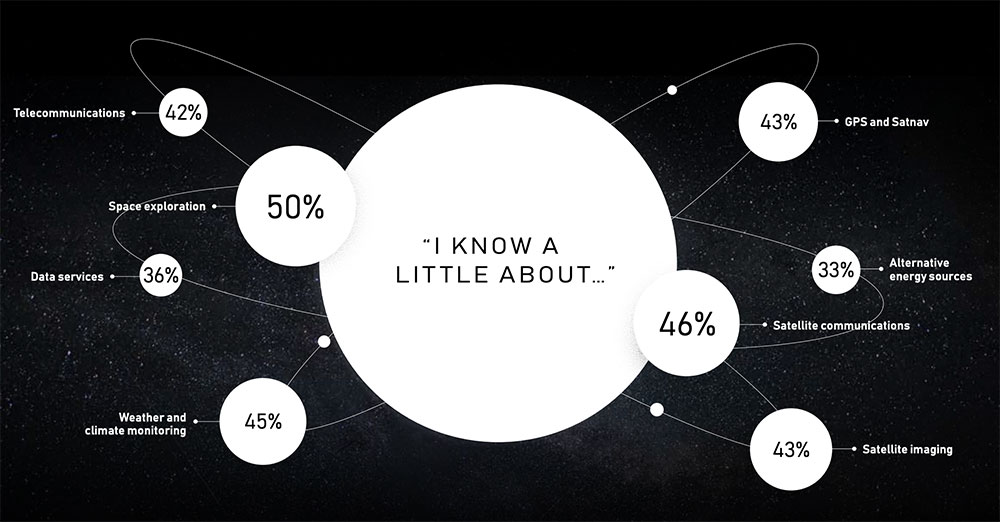
The survey found that most people have no idea about the benefits of space. Only one third are excited about space, with 47% concerned about space junk and just 8% associating space with communications and connectivity.
Just 8% of respondents associate space with communications and connectivity.
“From connecting rural communities to helping solve climate change, we know the enormous potential space holds to improve life on Earth, and what it has already brought us,” Inmarsat said in a statement. “Now, both the magnificent possibilities and the potential risks of space, which Inmarsat is working hard to address, need to be showcased to the world.”
The report also features contributions from renowned figures in the sector including Scott Kelly, former astronaut and commander of the International Space Station, and Josef Aschbacher, director general of the European Space Agency.
“The research findings mark a real wake-up call for the space industry,” Inmarsat said. “It’s clear that people have a low understanding of the breadth and richness of the work being done in space today. Perhaps because the technology deployed is essentially invisible, people do not appear to understand the role space is already playing in their everyday lives, nor its potential to deliver a brighter future for our planet.”
ComNav Technology now provides a GNSS high-precision positioning solution for navigation and positioning of autonomous lawn mowers. Environmentally friendly and intelligent robotic lawn mowers are growing more popular, making the mowing task easier, safer and more convenient.
R&D background
It is difficult to develop autonomous lawn mowers because they obtain navigation information by means of visual and acoustic sensors, usually through embedded cables in the working area and detection through eddy current sensors. The shortcomings are obvious: before the mower starts, it must be set up with cables and other equipment. Cable requirements differ in various countries, and cable laying can be complicated, wasting resources and money.
With these difficulties in mind, ComNav applied its K8 series of GNSS high-precision modules to lawn mowers to break through the application limit. It solved this accuracy problem to make the lawn mower achieve centimeter-level driving according to the setup path in an open field. With ComNav’s other technologies — quantum algorithm and LAI, HighLock, PPP, RTK-KEEP — the law mowers continues to operate under trees, around corners or in other obscured areas.
Introduction of ComNav’s solution
With the K8 series module, ComNav facilitates the lawn mower’s fieldwork with position data provided by GPS, GLONASS, Galileo, Beidou, QZSS, IRNSS and SBAS.
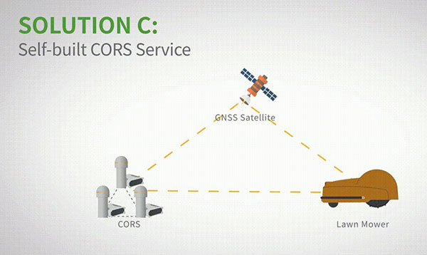
The high-precision positioning system for lawn mowers consists of a base station and a rover station. Three solutions are recommended for the terminal to obtain differential data from the base station.
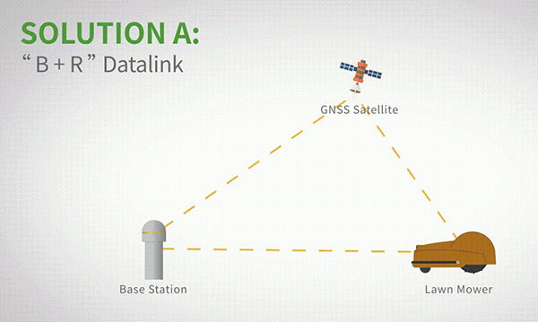
Base and rover datalink. A base station acquires differential data through a datalink and provides corrections to the rover. The rover station — comprising the parts installed on the lawn mower, including the GNSS antenna, the GNSS high-precision module, datalink and UHF antenna — enables centimeter-level positioning and navigation.
Image: ComNav
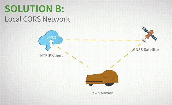
Local CORS network. Utilizing existed local CORS, the rover station obtains differential data from the CORS service, enabling the lawn mower to achieve positioning and navigation accuracy on a centimeter level.
Image: ComNav
Self-built CORS network. Base stations can be placed anywhere based on requirements. Doing so eliminates the worry about prevailing conditions and makes high-precision positioning and navigation of lawn mowers possible.
Image: ComNav
Technology Features
LAI technology. ComNav’s patented low-power anti-interference (LAI) technology provides a jamming-to-signal ratio of up to 50 dB. Power consumption is only 0.1 W when turned on. By quickly detecting and eliminating interference with simple settings, LAI technology can reduce failure time and ensure safe operation. The technology can generate a spectrum diagram of interference sources, enabling identification of interference types and potential interference sources.
Quantum algorithm. ComNav’s quantum algorithm has sophisticated technology for detecting and repairing cycle slips. It uses full-constellation and full-frequency tracking capabilities along with multi-frequency combination, model and parameter estimation. Quantum is able to eliminate errors caused by the ionosphere, the troposphere and multipath in seconds. As a result, the initialization time of real-time kinematic (RTK) is greatly shortened and precision and reliability are improved. Meanwhile, the extra-long baseline calculation capability expands the operation range.
RTK-KEEP technology. By estimating model and parameter values, RTK-KEEP Technology can reduce errors caused by satellite orbit, clock difference, ionosphere and troposphere when the base station’s data is lost. Centimeter-level accuracy can be kept for more than 10 minutes, greatly improving the availability of RTK.
Benefits of ComNav’s Solution
ComNav’s solution allows the lawn mower to achieve centimeter-level positioning and reduce mowing repetitions. It helps the lawnmower to operate safely and reliably in the corners, under trees, or in other places where satellite signals are weak or lost. With its strong anti-interference capabilities, the lawn mower can maintain continuous and effective positioning in complex environments, meeting the needs of a variety of applications.
The IAG International Symposium on Reference Frames for Applications in Geosciences (REFAG 2022), which is organized by the Aristotle University of Thessaloniki under the scientific coordination of Commission 1 of the International Association of Geodesy, will be held in Thessaloniki, Greece on October 17-20.
REFAG 2022 aims to address today’s theoretical concepts of reference systems and their practical implementation by space geodetic techniques and their combinations, underlying limiting factors, systematic errors and novel approaches for future improvements. The symposium welcomes contributions in all aspects of geodetic reference frames and their applications in Earth science studies, satellite navigation, and also other key areas of geomatics and geospatial information systems.
The scientific program of the symposium covers all topics related to the activities of IAG Commission 1 and its subgroups, including also other initiatives and projects which endorse the role of geodetic reference frames towards scientific exploration, sustainable development, land administration, disaster risk reduction and climate monitoring.
The deadline for abstract submissions for the symposium will be until July 20. Accepted abstracts will be notified by e-mail to the corresponding author by July 30. The submission form and submission information can be found at https://www.refag2022.org/abstract-submission/abstract-general-information/.
Early bird registration is available for REFAG 2022 until July 25. Registration information can be found here.
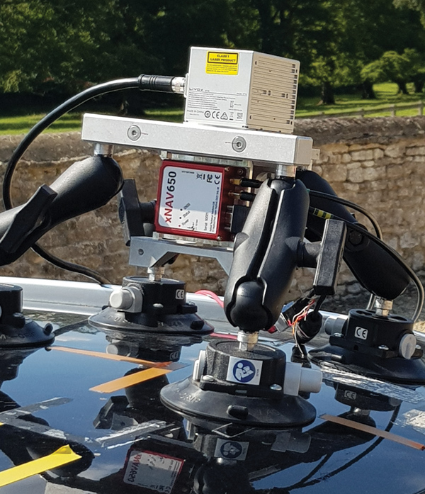
Mobile mapping using an OxTS xNAV650 INS and lidar sensor. Photo: OxTS
We discussed mobile mapping with Jacob Amacker, application engineer, OxTS.
How do you define “mobile mapping” as opposed to “surveying”?
We use the two terms interchangeably. Each one has a different connotation depending on where you are in the world and both can be useful. We use them to cover a broad range of use cases, but “mobile mapping” is used more specifically for land-based mapping of the environment. A typical application might be a van equipped with an INS [inertial navigation system] and lidar sensors.
“Surveying” can be used a bit more generally, applying to aerial or pedestrian-based mapping, but it does have the connotation of static mapping, which we do not typically handle.
What are your main markets for mobile mapping?
It is very hard to say. The world of mobile mapping is so diverse. However, lidar mapping could be seen as both the largest and the fastest-growing market in the surveying world as lidar has become widely affordable. Although our technology can be used with any surveying devices, at OxTS we particularly like to use lidar and are focusing on getting the best results from lidar data. This has included making our own point-cloud georeferencing software to maximize the potential of our navigation data in making point clouds.
What are the main differences between your devices for aerial mapping and for ground-based mapping?
We use the same INS device for both ground and aerial mapping. For use on manned aircraft, we would always recommend our highest accuracy system with the best IMU, the Survey+. The main source of inaccuracy in survey data will come from the IMU error over the range to the objects. Because most of this range is the aircraft’s altitude, this error is quite significant. For land-based mapping work, the measurements provided by the lighter and smaller xNAV650 are still suitable for many high-precision applications.
GNSS-INS integration has been done for decades. What is new and what are the remaining challenges?
It is now much more affordable to have very high-grade IMUs and GNSS receivers. Nevertheless, there will always be further improvements to be made to how the data streams are combined. On a similar note, other navigation aiding sources are increasingly being considered to supplement the IMU and the GNSS receiver — such as wheel speed sensors, lidar, camera odometry and others that can also be integrated to stabilize and improve the navigation data. Overall, it is very exciting what is yet to come out of INS technology. In recent years, it has become so good that people expect more and more from it, and this demand must be met. What happens when GNSS drops out? We are seeing increasing development to make the navigation data robust against challenges of any environment.
Given the IMU’s drift, for how long can your system function at an acceptable level in case of a GNSS outage?
It is difficult to put a number on what kind of drift is acceptable, as it depends on the application and the end-user requirements. Typically, half a meter of drift in one minute of GNSS-outage might be the goal for some of the higher-grade surveyors. Still others might only be satisfied with negligible drift.
What keeps the INS and the lidar unit synchronized during a GNSS outage?
The INS has an internal clock to keep the timing during a GNSS outage. Of course, this will not be as accurate as the atomic clocks on the satellites, but it is quite adequate to maintain survey-grade accuracy during GNSS outages. GNSS is still necessary to get the timing information in the first place, and this is a reliance that INS devices will want to remove in the future.
What are the key remaining technical challenges in UAV lidar mapping?
With continuing improvements in UAVs, lidars, GNSS receivers and other sensors, the key to unlocking more efficiency and profitability in this market will be improving and simplifying workflows and processing. The next frontier is integrating AI and machine learning with digital twin models to create forecasting tools.
UAVs are much cheaper to operate than manned aircraft per hour, but not necessarily per square mile. UAVs can cover ground that cannot be mapped from a land vehicle; however, the latter have a much greater range.
You are correct. Each type of vehicle has its area of best utilization. Once we know what the customer wants from the data being collected, we can determine the size, weight and power (SWAP) of the payload needed, and then it’s a matter of analyzing cost versus capability and working with the customer to pick the right payload for the right vehicle at the right price.
What positional accuracy do you achieve for your point clouds?
With our GNSS-receiver-based navigation unit, which also includes an IMU and key IP [intellectual property] from our company, and the right combination of tools, we achieve an accuracy of 2 cm to 3 cm.
What are your key markets for UAV lidar mapping?
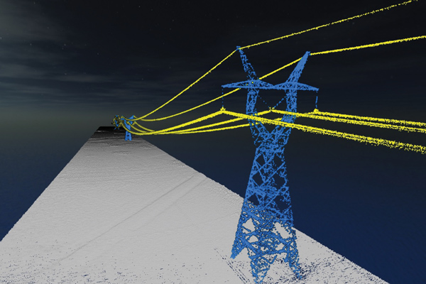
I believe it is still the Wild West in this market space. Really smart people are figuring out new ways to use these systems every day. We sell systems to teams doing high-end inspections of infrastructure, such as roads, bridges, corridors and power lines, as well as for land surveying and mining.
What was a recent application of one of your mapping systems?
One of our most recent success stories has been the launch of our Geo-ECTO-1 system. It features dual lidar sensors combined with a 360-degree FOV [field of view] camera and high-end GNSS receiver. It is ruggedized from the ground up and is meant for high-end survey and infrastructure inspection work. The payload is designed to quickly transition to a UAV-based system. Our two launch customers/partners are California-based survey companies Guida Survey and LACO Survey. It has been a great experience getting these systems up and running with our partners.
Our next adventure will be to work with UC San Diego’s Scripps Oceanographic Institute. We are proposing and demonstrating one of these systems to be used for analyzing cliff erosion on the beaches here in California, where several collapses have led to the loss of life. We want to support figuring out how to use the analyses to create a system that would give early warning of trouble spots. With these tools we can make our beaches much safer.
In 2020, OCP-TAP started working on highly precise and hyper-scalable time synchronization services in its data center market, using a GNSS clock source and precision time protocol (PTP) technologies. OCP-TAP technology adds scalability and improves the accuracy of timekeeping within the infrastructure industry.
In 2021, OCP-TAP integrated its technology into the time card and introduced it as an open-source solution to build time servers.
The Protempis Res720 embedded module provides a highly accurate GNSS clock source to further increase the accuracy, resiliency and adoption of the OCP-TAP’s new time card duo, which was announced in an OCP Tech Talk on June 2.
OCP-TAP provides a new collaborative community focused on designing hardware and software to efficiently support critical timing accuracy and resiliency demands on computer network infrastructure.
Protempis Res720
Protempis’s Res720 embedded module adds a dual-band GNSS time reference to the time card to improve resilience, noise rejection and anti-spoofing and anti-jamming capabilities.
The Res720 GNSS embedded timing module is suitable for data centers, 5G Open RAN and XHaul, smart grids, industrial automation and SATCOM networks. It provides 5 ns timing accuracy, dual-band GNSS support and anti-jamming/anti-spoofing capabilities.
The Res720 embedded module provides unparalleled performance as a timing source in embedded systems, including to time servers, network interface cards, radio units and routing/switching devices for 5G, private wireless, Open RAN and data networks.
“Protempis brings its expertise in GNSS and network synchronization to Meta, the OCP-TAP, and the open-sourced time card. Their highly accurate dual-band GNSS product has shown how it can improve operations,” said Ahmad Byagowi. Byagowi is inventor of the Time Card, founder and project lead for OCP-TAP, and a research scientist at Meta.
“We are honored that our Res720 dual-band technology will be used for enabling time-sensitive applications over OCP-compliant and PTP-aware networks,” said Karen Guldan, Protempis president. “We look forward to a continuing partnership with OCP-TAP and global network leaders working to advance solutions to provide ongoing timing accuracy and resilience.”
Precisional, an affiliate of The Jordan Company (“TJC”), announced May 9 that it completed the previously announced transaction to acquire four industrial technology businesses from Trimble, including Protempis (formerly Trimble Time and Frequency).
“Seen & Heard” is a monthly feature of GPS World magazine, traveling the world to capture interesting and unusual news stories involving the GNSS/PNT industry.
Xona’s first demonstration mission successfully completed testing at Experior Laboratories and prepares for launch on a Falcon 9 in May. (Photo: Xona)
TAKING GNSS PRIVATE
At press time, Xona Space Systems’ first in-space demonstrator satellite, named Huginn, was ready to launch on May 25 aboard Space X’s Transporter 5 mission. Xona said the launch is a significant step toward realizing its high-performance commercial navigation system, a constellation of small, powerful satellites in low Earth orbit that will meet the navigation and timing needs of intelligent systems.
U.S. cellular carrier AT&T is rolling out location-based routing to automatically transmit wireless 9-1-1 calls to the appropriate call centers, rather than relying on which cell tower handles the call. Cell towers can cover a 10-mile radius, and overlap with more than one call-center boundary. With location-based routing, a device can be located and routed within 50 meters of the device location. The “Locate Before Route” feature from Intrado enables AT&T to use device GNSS and hybrid information to route the call to the right call center.
Russian jets have been found using GPS receivers, while ground vehicles use paper maps, according to the UK Express. The GPS receivers were found taped to the dashboards of Russian SU-34s downed in Ukraine because of “the poor quality of their own systems,” UK Defense Secretary Ben Wallace said in a speech. With many reports of maintenance and aging issues for the Russian military, most likely the jets did not have quality GNSS receivers rather than the fault lying with GLONASS.
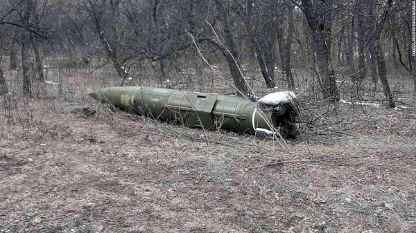
A Russian short-range ballistic missile, believed to be an unexploded Iskander missile, was found near Kramatorsk, Ukraine, in this photo released March 9 by Ukrainian authorities. (Photo: National Guard of Ukraine handout via Reuters)
UNEXPLODED BOMBS MAPPED
The HALO Trust is partnering with Esri to map unexploded ordnance in an immediate humanitarian response to the war in Ukraine. More than 10 million Ukrainians have been displaced by the war and many are forced to move across a landscape littered with unexploded rockets, bombs and landmines. In response, Esri has committed its cutting-edge geographic information system (GIS) software resources, expertise and staffing in support of HALO’s mission in Ukraine. HALO already is using GIS to map the heaviest conflict zones, and the partnership with HALO will support planning for future clearance operations.
Skydel 22.5 features advanced hardware-in-the-loop testing
Orolia has released Skydel 22.5, a significant software upgrade to its Skydel simulation product line that features advanced hardware-in-the-loop (HIL) testing solutions providing very low to zero effective latency.
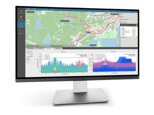
The enhanced visualization tools can monitor internal latency through real-time curves showing when the data is generated and sent to the RF signal. Users can also review the transmission of HIL packets for optimizing the entire network’s latency, checking its stability (jitter), and that data is available and used at the right time in Skydel.
HIL testing is an essential step in the verification process of the model-based design (MBD) approach because it involves all the hardware and software that will be used operationally. HIL verification can test a standalone device-under-test (DUT) or, more generally, an entire complex system consisting of multiple DUTs in both open- and closed-loop architectures.
“The vast majority of problems encountered by engineers on HIL systems are related to poor control of the latency of the entire simulation chain, as they are insufficiently accessible, transparent and controlled on the competing systems,” said Pierre-Marie Le Veel, principal system architect and product manager for GNSS simulation. “Thanks to these tools, our high-end performance and well-known intuitive automation, Skydel dramatically reduces the implementation time of a HIL system (which can be very significant) and, therefore, the project’s overall cost.”
Photo: Orolia
In addition to these tools, Skydel implements modern extrapolation algorithms that achieve zero effective latency. These algorithms make it possible to keep position errors negligible, even for equipment with very high dynamics used in national defense applications such as missiles, rockets and guided shells.
“These advanced HIL algorithms and tools are available – and with the same performance – on our Wavefront simulation systems to test controlled reception pattern antenna (CRPA) systems,” Le Veel added.
Additional constellations, signal types and options such as real-time kinematic (RTK) and multi-instance are available along with dedicated bundled simulation starter packages for automotive.
The upgrade is available at no additional cost for existing users operating Skydel 22.5. Application notes, support documents and tutorials are available online.
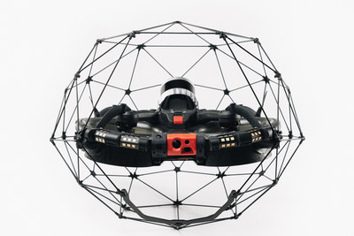
Flyability has unveiled the Elios 3, a collision-tolerant drone equipped with a lidar sensor for indoor 3D mapping. The drone is powered by a new SLAM engine called FlyAware that lets it create 3D models as it flies.
It also is accompanied by a new version of Flyability’s software for inspectors, Inspector 4.0.
The launch of the Elios 3 marks a new partnership with GeoSLAM. The Elios 3 comes with an Ouster OS0-32 lidar sensor, allowing inspectors to collect data for the creation of survey-grade 3D models using software from GeoSLAM.
The drone gives users real-time digital replicas of previously inaccessible areas with the inclusion of the lidar sensor and GeoSLAM’s Connect software. The drone is protected by a cage and has advanced collision-tolerance features that allow inspectors to fly it inside dangerous confined spaces such as boilers, pressure vessels and mines.
With its integration with Connect, the Elios 3 creates survey-grade point clouds. Fitted to the back of the drone, the lidar sensor maps the environment in real time using Flyability’s FlyAware SLAM algorithm.
Survey package option
Those that need highly accurate data can upgrade to the survey package, provided by GeoSLAM, providing access to the Connect software, as well as specialist Volumes and Draw modules. Powered by GeoSLAM’s established SLAM algorithm, Connect offers a simple and automated way to process point cloud data.
Using the survey package, data is processed to an accuracy of 8 mm, suitable for mapping hazardous environments such as mines and industrial applications including chimneys, production plants, warehouses, silos and tanks. Processed data can then be viewed in the easy-to-use 3D viewer and exported to industry-standard file types including LAZ, LAS, PLY and TXT for use in third-party software.
The Boston Dynamics Spot robot equipped with Velodyne lidar. (Photo: Velodyne)
Velodyne Lidar Inc. has signed a multi-year agreement for its lidar sensors with Boston Dynamics, a mobile robotics company best known for its “Spot” dog-like robot.
Boston Dynamics selected Velodyne’s sensors to provide perception and navigation capabilities for its highly mobile robots. The sensors enable mobile robots to operate autonomously and safely, without human intervention. They provide real-time 3D perception data for localization, mapping, object classification and object tracking.
Velodyne’s power-efficient sensors support autonomous mobile robots in a wide range of challenging indoor and outdoor environmental conditions, including varying temperature, lighting and precipitation, the company said.
Velodyne’s lidar sensors will enable the robots to autonomously navigate complex environments, safely avoiding obstacles and finding the fastest route to perform tasks in environments from manufacturing plants and construction sites to distribution centers and warehouses.
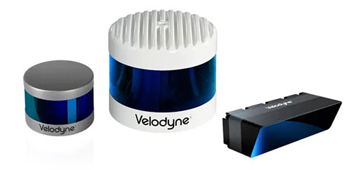
The Alpha Puck, Alpha Prime and Velarray M1600 lidar sensors. (Photo: Velodyne)
Manuscripts submissions are being sought for a special issue of Applied Sciences, which will be dedicated to “Recent Advances in GNSS High-Precision Positioning and Applications.”
Deadline for manuscript submissions is Dec. 30. Full instructions are available on the special issue website.
The goal of the special issue is to highlight recent developments in high-precision GNSS positioning models, algorithms and applications. The topics of interest include, but are not limited to, the following:
multi-GNSS multi-frequency PPP, RTK, PPP-RTK models and algorithms, making use of high-grade and low-cost equipment
quality characterization of smartphone GNSS observations
functional and stochastic models for multi-GNSS precise positioning with smartphones
characterization and handling of multi-GNSS inter-system and inter-/intra-frequency code and phase biases
ionospheric and tropospheric modeling
carrier-phase ambiguity resolution
GNSS-LEO observation modeling and integration
integrity monitoring
GNSS-based lunar navigation
satellite orbit dynamics.
Special-issue editors are Safoora Zaminpardaz and Dimitrios Psychas.