South Korea has successfully launched a precision aviation satellite Thursday by leasing space on Malaysia’s MEASAT-3d communication satellite for 15 years, reports The Korea Herald. The first satellite for the Korea Augmentation Satellite System (KASS) will improve the accuracy and reliability of GPS signals for pilots, increasing airline flight safety.
The satellite lifted off from Guiana Space Center in Kourou in French Guiana at 6:50 a.m. Thursday (Seoul time), and successfully separated from the rocket at around 7:18 a.m. after the fairing and first stage rocket separations.
In development since 2014, the KASS system can improve the GPS position error to 1.0 to 1.6 meters from the current 15-33 meter level in real time to ensure positioning reliability throughout the country.
The government plans to begin a pilot service around December before its full-fledged operation next year.
South Korea is the seventh country to have a geosynchronous satellite system officially registered with the International Civil Aviation Organization (ICAO). The others are the United States, Russia, China, the European Union, India and Japan.
The Korea Augmentation Satellite System will improve airline safety over Korea. (Photo: ugurhan /iStock/Getty Images Plus/Getty Images)
Septentrio’s latest GNSS boards and modules now support PX4 Autopilot for faster integration of high-accuracy positioning into UAVs and robots.
Both the AsteRx-m3 and mosaic receivers support PX4 Autopilot, opening the door to reliable and resilient real-time kinematic positioning.
PX4 Autopilot is one of the largest commercially adopted open-source navigation control stacks, enabling an innovative community to build and maintain drone hardware and software in a scalable way. Drones and robots, which operate autonomously or where a high level of safety is required, now benefit from Septentrio’s accurate positioning receivers, known to be secure against GPS jamming and spoofing with built-in AIM+ Advanced Interference Mitigation technology.
“Our developer community is looking forward to integrating Septentrio’s secure GNSS positioning technology into UAVs and robots, especially in those applications where reliability matters from mapping to surveillance and delivery,” said Ramon Roche, general manager, Dronecode Foundation. “Septentrio’s presence and talk at the PX4 Developer Summit will be an opportunity for developers and integrators to connect with Septentrio and to learn about the latest high-accuracy positioning tech for the PX4 ecosystem.”
“Septentrio has had a fantastic collaboration momentum with Dronecode and the larger PX4 community during the integration of Septentrio receivers into the PX4 Autopilot ecosystem,” said Gustavo Lopez, market access manager at Septentrio. “This collaboration is important because it brings resilient and secure GPS technology to the UAV industry, with tremendous potential in terms of assured positioning and improved safety.”
PX4 is supported by Septentrio’s GNSS boards and modules with both single-antenna and dual-antenna configurations, which offer either heading and pitch or heading and roll angles on top of accurate GNSS positioning.
The Septentrio PX4 driver is freely available on the GitHub.
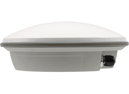
Harxon has launched a high-precision GNSS antenna, the HX-CSX633A. The HX-CSX633A has an upgraded architecture for more durable use and more flexible installations, making it suitable for agricultural vehicles, small robots and surveying applications.
Photo: Harxon
The HX-CSX633A features a durable, future-proof design with an IP67 waterproof housing. It meets MIL-STD-810-H for vibration and shock, increasing robustness for use under high-vibration conditions. The HX-CSX633A supports flexible installations including magnetic mount, screw mount and pole mount. Consequently, integrators can be confident this powerful antenna can be used in system designs for years to come, the company said.
The HX-CSX633A is fully functional, powerful and stable. The phase center remains constant with a multi-point feeding design. The ability to receive low-elevation signals with high gain and wide beamwidth makes it suitable for tracking visible satellites in tough environments, Harxon said.
The antenna’s low-noise amplification (LNA) features excellent out-of-band rejection, which can suppress electromagnetic interference and prevent disconnection when receivers are operated in complex electromagnetic environments.
Key Features of the HX-CSX633A:
supports GPS, GLONASS, Galileo, BDS, QZSS, IRNSS and SBAS signal reception
stable phase center guarantees positioning accuracy within the millimeter-level
strong anti-interference ability to endure challenging operating environments
M3 Systems and TilT Consulting on June 1 were declared winners of the MyEUspace Competition 2021 for their passive radar for detection and localization of obstacles based solely on GNSS signals.
The SANGENE project (Sens And Navigation on GNSS ENvironment Estimation) aims to demonstrate the concept of an integrated GNSS-based passive radar for the detection and first localization of obstacles.
The SANGENE solution is a passive radar technology based solely on GNSS signals integrated into a localization and navigation device currently available onboard an aircraft or a drone. Today’s operational navigation equipment often use a combination of equipment to identify and locate other carriers or obstacles, but these means do not permit detection and visualization of non-equipped or uncooperative carriers, and can be a source of danger.
As “signals of opportunity,” GNSS signals can be used for detecting obstacles. With reflected signals, GNSS satellites behave as multiple radar signal sources that are widely available while remaining discrete.
This principle of passive detector also makes it possible to increase the localization capacity of the GNSS devices already present, without having any major architectural changes to their design.
Within a few months, this solution has passed from a first level of concept and definition to an implementation model. With the impetus provided by the competition, the validation phase will soon begin.
The MyEUspace Competition was organized by the European Union Agency for the Space Program (EUPSA) to support development of innovative commercial solutions — such as mobile apps or hardware-based solutions — that leverage Galileo or Copernicus EU space data.
Burkhard Boeckem and a Boston Dynamics robot dog share insights into smart digital realities. (Photo: Hexagon)
At HxGN LIVE Global 2022, in-person attendees experienced the full breadth of what the flagship conference has to offer for the first time since 2019. The conference is taking place this week at the Venetian hotel in Las Vegas.
Tuesday began with a keynote address by Burkhard Boeckem, chief technology officer, who discussed the importance of smart digital realities and their role in the potential of the metaverse to impact and enhance the physical world. Hexagon’s technology platform Xalt enables intelligence at scale. By integrating sensors and data integration across systems and solutions, like the BLK series and HxDR, Xalt provides the next level of connectivity to harness and utilize data for autonomous systems.
Summit-specific keynotes by speakers from Hexagon, its partners and sponsors provided expertise on issues, solutions and innovations shaping and reimagining various industries.
The Digital Innovation in Construction summit begins. (Photo: Hexagon)
Tuesday was also the first day of breakouts for all summits, with more than 100 sessions throughout the day covering everything from training and tips for Hexagon products to project success stories, panel discussions of industry trends, and a look at the precision engineering of Formula 1 cars with Hexagon partner Oracle Red Bull Racing. Sessions continue through the close of the conference on Thursday.
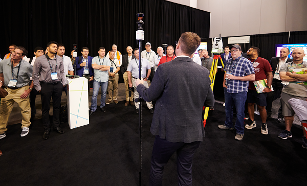
The Zone, the massive technology expo floor, officially opened for the first time this morning, where attendees explored some of the latest advancements, products and solutions available across seven summit-specific “islands” offering hands-on demonstrations and an opportunity to ask the questions that will help them make the best use of autonomous technology in their field.
Surveyors get the lay of the land at the Pure Surveying Island. (Photo: Hexagon)Advances in digital construction were provided by Leica Geosystems. (Photo: Hexagon)
In the evening, summit events took attendees around the grounds of the Venetian resort for various experiences.
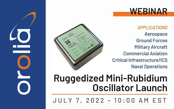
Latest atomic clock designed for commercial, military and aerospace operations; launch webinar scheduled for July 7
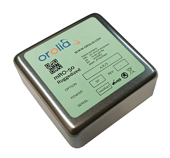
Photo: Orolia
Orolia has introduced an upgraded edition of its low size, weight, power and cost (SWaP-C) miniaturized rubidium oscillator product line, the mRO-50 Ruggedized, to meet the latest military and aerospace requirements where time stability and power consumption are critical.
The mRO-50 Ruggedized provides a one-day holdover below 1 µs and a retrace below 1E-10 in a form factor (50.8 x 50.8 x 20mm) that takes up only 51 cc of volume (about one-third of the volume compared to standard rubidium oscillators) and consumes only 0.36 W of power, which is about 10 times less than existing solutions with similar capabilities, the company said.
With these competitive advantages, the new mRO-50 Ruggedized miniaturized rubidium oscillator provides accurate frequency and precise time synchronization to mobile applications, such as military radio-pack systems in GNSS-degraded or denied environments. Its wide-range operating temperature of -40°C to 80°C is also suitable for a wide range of applications such as underwater, military communications, radars, low Earth orbit, electronic warfare, airborne and unmanned vehicles.
“Our dedication and innovative design have contributed to the most accurate GNSS systems in service today,” said Jean-Charles Chen, Orolia Atomic Clocks Product Line director. “Orolia launched the mRO-50 in 2020, bringing the best rubidium technologies into one small form factor and ultra-portable packaging.”
The mRO-50 Ruggedized enhances this breakthrough technology with modifications providing wider thermal range, quicker lock and higher stability.
Orolia’s timing solutions support space agencies and research institutes worldwide, including the European Space Agency (ESA), NASA, Jet Propulsion Laboratory, SpaceX, Blue Origin, the Centre National d’Étude Spatiales (CNES France), the National Physics Laboratory (NPL UK), Deutsches Zentrum für Luft- und Raumfahrt (DLR Germany) and the Japan Aerospace Exploration Agency (JAXA).
ESA awarded Orolia two contracts to provide atomic clocks for the first 12 satellites for the Galileo Second Generation System. Each of the new satellites, designed to provide unprecedented accuracy worldwide, will contain three Orolia Rubidium Atomic Frequency Standards (RAFS) and two Orolia atomic clock physics packages integrated with Leonardo’s Passive Hydrogen Masers (PHM).
Septentrio, a leader in high-precision GNSS positioning solutions, has appointed Peter Fairhurst as new vice president of Sales. In this role, Fairhurst will lead the sales and application support teams at Septentrio globally.
Fairhurst succeeds Neil Vancans, who is retiring at the end of June, and who has led Septentrio sales for the last five years.
Fairhurst joins Septentrio with 15 years of experience in the GNSS industry. He most recently was head of Product Strategy at ublox. Before that, he worked many years at Leica Geosystems.
“Peter is an experienced business leader with a proven track record of creating value for customers and fits perfectly in our vision to help our customers be successful in their markets,” said Antoon De Proft, CEO of Septentrio. ”Peter will play a crucial role in implementing our growth strategy and empowering our sales teams to solve our customers’ mission-critical positioning challenges.”
“I am thrilled to join Septentrio and to bring their world-class GNSS solutions to industrial customers around the globe,” Fairhurst said. “Septentrio has unique capabilities and products and is an ideal partner for industrial OEMs for whom reliable and accurate positioning is crucial for their success.”
The EU Agency for the Space Programme (EUSPA) is set to launch a new Fundamental Elements call, with a dedicated online workshop June 30. The workshop is an opportunity to learn about the new call and hear from successful projects funded during the last call.
Fundamental Elements is a research and development funding mechanism designed to support the development of innovative chipset, antenna and receiver technologies in which industry would not yet invest on its own initiative. In doing so, the program helps accelerate the integration of European GNSS (EGNSS) into market-ready devices and solutions.
Projects funded by Fundamental Elements play a key role in EUSPA’s mission of driving the development and market uptake of Galileo-enabled receivers. For example, the GEARS project, which was funded during the initial call, developed a super accurate and highly robust Galileo-enabled receiver capable of providing both time and frequency data for critical infrastructure.
The new Fundamental Elements call builds on success of projects by:
integrating Galileo’s key differentiators into receiver technologies, including OSNMA, high-accuracy frequency, triple frequency, Early Warning Service, CAS and ARAIM
leveraging disruptive technologies such as machine learning and artificial intelligence
exploring potential synergies with Copernicus and the forthcoming GovSatCom.
More details about these points and the call in general will be made available during EUSPA’s upcoming Fundamental Elements online Workshop via Webex. Scheduled for June 30, the workshop will include in-depth information on the funding program and the application process.
The event will also feature project teams funded during the first Fundamental Elements call, who will share their experiences, best practices and advice for putting together a successful project.
HxGN LIVE Global 2022, taking place this week in Las Vegas, is a cross-industry conference showcasing the latest technologies and innovations from Hexagon.
The first two days brought numerous announcements and demonstrations. Here are a few highlights.
Hexagon unveils mining smart platform
The new Power of One platform is a holistic, life-of-mine smart solution connecting sensors, software, infield apps and cloudware. Available and ready to implement, the technology connects the mine to the boardroom via a single onboard ecosystem. Harnessing data from multiple sensors in a simple and consolidated software architecture, the platform helps mines to become situationally aware, self-learning and autonomously connected in the field and in the cloud.
For the customer, the platform offers an effortless experience with a seamless UI/UX and consistent functionality. Reduced cost of ownership, reduced deployment and training time, reduced supply chain complexity and increased operator adoption are just some of the platform’s many benefits.
“The Power of One platform is a landmark enabler for next-generation autonomy,” said Nick Hare, Hexagon’s Mining Division president. “It offers mines a uniquely intelligent approach based on open architecture to autonomously connect key mining ecosystems, such as exploration, planning, drill and blast, material movement and mine monitoring. “It’s the scalable, platform-agnostic answer to challenges previously addressed by point solutions and multiple vendors.”
HxGN LIVE Global visitors can learn more about the Power of One platform during this week’s Intelligent Mining Summit.
Ola Rollén, president and CEO of Hexagon, delivers the keynote address at HxGN LIVE 2022. (Photo: Hexagon)
Hexagon and Fujitsu announce strategic partnership
Hexagon’s Safety, Infrastructure & Geospatial division and Fujitsu Limited will partner to accelerate the development and promotion of use cases to solve societal challenges and contribute to the realization of the “Trusted Society” — a sustainable, resilient place where people can live together in peace and prosperity.
Hexagon and Fujitsu will work together to provide joint use cases leveraging digital-twin technologies and solutions from both companies, including sensors, data processing, data analysis and advanced data visualization in the cloud and high-performance computing infrastructure. The partners will deploy these technologies to develop joint solutions that deliver richer information and deeper insight to customers in government, the public sector, transportation and utilities to help reduce emissions, increase safety, optimize operations and more.
“Our goal at Fujitsu is to realize our vision for a ‘Trusted Society’,” said Yoshinami Takahashi, EVP and vice head of Global Solution Business Group, Fujitsu. “Partnering with Hexagon will allow us to extend our reach and provide even greater value to cities and regions around the world.”
“Cities are playing a leading role in solving global challenges, from addressing climate change to eliminating traffic fatalities,” said Steven Cost, president, Hexagon’s Safety, Infrastructure & Geospatial division. “Our partnership with Fujitsu can help cities put data to work to solve these pressing problems and meet sustainability and safety goals.”
The new global partnership builds from the companies’ work to solve urban sustainability challenges in Europe, including efforts to better manage and understand the impacts of shared mobility services in Germany, including a project with the City of Munich.
Hex-E, the Hexagon mascot, peruses a map during HxGN LIVE 2022. (Photo: Hexagon)
HxGN EAM asset management software leads in Green Quadrant
HxGN EAM from Hexagon’s Asset Lifecycle Intelligence division was named a leader in the enterprise asset management (EAM) market in the Green Quadrant: Enterprise Asset Management Software 2022 report from Verdantix.
Verdantix is an independent research and advisory firm with expertise in digital strategies.
HxGN EAM received the highest weighted score for the technical capabilities of the platform. The report assessed 14 EAM software vendors across their product functionality, user interface and market momentum.
Verdantix estimates that global spending on EAM will reach $5.4 billion in 2026, compared to $3.6 billion in 2021, and states that acquisitions and funding are reshaping the EAM market. This comes just after Hexagon’s $2.8 billion acquisition of Infor’s EAM software business to form HxGN EAM in 2021.
“HxGN EAM’s growth ambitions align with the market outlook and Hexagon’s vision to be the world leader in digital realities and autonomous solutions,” said Kevin Price, vice president, Enterprise Asset Management Portfolio Segment, Hexagon’s Asset Lifecycle Intelligence division. “Asset visibility is the first step in proactive maintenance and the prevention of the breakdown of critical functions, and we’re proud that HxGN EAM’s wide availability of services matches the growing needs of our customers. It’s an honor to be classified as a leader in the EAM market.”
Hex-E gets excited about his reflection at HxGN LIVE 2022. (Photo: Hexagon)
Hexagon Elite Awards recognize customers
Hexagon’s Asset Lifecycle Intelligence (formerly PPM) division announced the recipients of the 2022 Hexagon Elite Awards, which honor Asset Lifecycle Intelligence division customers who are champions of progress and innovation using Hexagon solutions.
“As we expand our portfolio and capabilities through acquisitions, our customers’ designs and animations using Hexagon solutions for this competition continue to amaze,” said David Cryer, Senior Vice President & Chief Marketing Officer, Hexagon’s Asset Lifecycle Intelligence division. “It’s an honor to recognize this year’s winners and we want to thank all of our customers who submitted entries.”
This year’s awards were presented in six categories:
Best in Design recognizes the most innovative and well-executed uses of Intergraph Smart 3D, Intergraph Smart Review and/or CADWorx: Fandy Maulana, Reformer Petrochemical Plant, PT Rekayasa Industri (Rekind).
Best in Automation rewards the most innovative automation ideas for Intergraph Smart 3D, Intergraph Smart P&ID, Intergraph Smart Electrical and/or Intergraph Smart Instrumentation: Petrobras – Surface Systems Engineering.
Best in Analysis recognizes innovative applications of CAESAR II, PV Elite and/or GT STRUDL that helped successfully complete a project and meet design and engineering goals: Chengwen Wang, Wuhuan Engineering Co. Ltd.
Best in Operations highlights customers who are true champions of progress and continue to move their company and industry forward in digital transformation in the Operations and Maintenance segments: Sudharshan Nambiar, Engineering Data Management – Systems, Petronas.
Best in Project Performance recognizes customers who use Asset Lifecycle Intelligence division and EcoSys solutions to successfully complete a project or improve project performance: Yann Guyot, Cost Control & Risk Management, Technip Energies.
Best in Procurement, Fabrication & Construction Management honors the most innovative and well-executed uses of the Asset Lifecycle Intelligence division’s PF&C solutions to successfully complete a project or move the company and industry forward in digital transformation: Jingwei Zhang and Zhifang Li, Zhengzhou Coal Mining Machinery Shuyun Intelligence Technology Co. Ltd.
Submissions for the 2023 Hexagon Elite Awards competition will be accepted starting Nov. 1.
Photo: Hexagon
Hexagon and Mineral Resources partner on automated road-train solution
Hexagon’s Autonomy & Positioning and Mining divisions announced the development of an automated road-train solution with mining services company Mineral Resources Limited (MRL). To be deployed on MRL’s haulage fleet, the solution integrates drive-by-wire technology with an autonomous management system to orchestrate vehicle movement in road-train haulage.
The automated road-train solution focuses on safety, productivity and sustainability for MRL operations and will be phased in over the next two years. Both companies are confident that progressive automation will profoundly change the safety and economics of mining where macroeconomic challenges, including commodity prices and labor shortages, impact the feasibility of projects.
The automated road-train solution improves the safety of long-range haulage, provides cost-efficiencies and reduces emissions to assist companies in lowering their carbon footprint. Beyond mining, this innovative solution will also benefit bulk haulage in many other off-road primary industries.
“Autonomous vehicles are revolutionizing the way we work today and into the future, and Hexagon is very proud to be part of this revolution,” said Ola Rollén, president and CEO of Hexagon. “Our agreement with MRL further solidifies Hexagon’s commitment to autonomous mobility and fulfilling our customer’s safety and productivity requirements.”
Reading her biography, you might not think that Jennifer Wexton, U.S. Representative for Virginia’s Tenth District, would be very connected to technology issues. As an attorney and government leader, she has spent a lot of time advocating for families, veterans and federal workers.
Yet she is also co-founder of the Congressional Task Force on Digital Citizenship and has become an advocate for protecting the nation’s vital positioning, navigation and timing (PNT) services.
“We all use GPS every day whether we know it or not, and we need to ensure it stays the gold standard for satellite navigation,” she said. “But as the National Security Council said last year, it has become a single point of failure for America. So much of our critical infrastructure depends on GPS, from the navigation apps on our phones to the military to our financial and energy sectors, and it is past time that we address its critical vulnerabilities and develop and implement reliable backup technologies.”
Wexton says that she has been aware of and concerned about the issue almost since the day she took her seat in Congress.
“I am a member of the House Appropriations subcommittee that oversees funding for the Department of Transportation, and civil GPS and PNT issues fall squarely in DOT’s jurisdiction,” she said. “In 2018, Congress passed a law requiring DOT to ensure we have a backup for GPS, and we updated that law earlier this year to ensure that all appropriate types of technologies are included in this effort. I don’t know how we can be comfortable with autonomous drones and self-driving cars if we don’t have technologies in place to support and back up GPS. They are certainly available.”
The fact that her district includes a huge swath of Virginia’s high-tech corridor has added to her knowledge of the problem and range of possible solutions. In addition to many big names in technology and government contracting, several smaller companies focusing on resilient PNT have offices in her district. These include Echo Ridge, Hellen Systems, Satelles and UrsaNav. All four participated in the Department of Transportation’s Complementary PNT and GPS Backup Technologies Demonstration.
Adding to her concern are increasing threats to GPS satellites and signals. At a recent hearing with DOT Secretary Pete Buttigieg, she mentioned Russia’s anti-satellite tests and ongoing GPS jamming in Ukraine as examples.
“And that might not even be the worst of it,” she later said. “We need to be cognizant of Chinese capabilities in cyber and in space. They have shown how they can physically grab one satellite with another and toss it out of orbit.”
At the hearing, she gently prodded Secretary Buttigieg about DOT’s progress toward protecting the nation.
“…in the FY-22 Omnibus we created a program which is housed at DOT and provided $15M to help develop the needed requirements and standards and conduct additional testing. […] How’s it going?”
Buttigieg temporized saying the department was working on the Congressional tasking in the appropriation with the funding available. That tasking focused on testing and developing standards as opposed to contracting for signals to begin making one or more alternatives to GPS widely available for adoption.
Funding for such an effort has been problematic since a 2018 law required DOT to establish a timing backup for GPS. Administrations have justified inaction by saying that Congress had not funded the effort. Yet hill staff report that for several years administration representatives vigorously opposed any funding at all during annual budget development negotiations. The $15M to establish the program within DOT this fiscal year, which Wexton supported, was the first time any allocation had been made.
Rep. Wexton is also a big supporter of GPS modernization. “GPS is the gold standard for satellite navigation and America’s gift to the world,” she said. “We have to continually modernize it to support both military and civil uses. That’s a no-brainer.”
She also sees deploying alternative timing and navigation systems a step to making GPS more secure. “Unlike the Russians and Chinese, we don’t have one or more systems widely deployed domestically if GPS is unavailable for some reason. This makes GPS satellites and signals prime targets for our adversaries, terrorists, and criminals. Having one or more alternatives will create redundancy and make GPS a much less attractive target.”
Providing one or more alternatives that could be widely adopted could be a relatively inexpensive proposition for the government, certainly when compared to the cost for GPS. More than $2 billion was appropriated for GPS operations and modernization this year. Industry sources estimate that contracts for the suite of alternative PNT sources described in the 2021 DOT report would cost a small percentage of that.
Dana A. Goward is President of the Resilient Navigation and Timing Foundation.
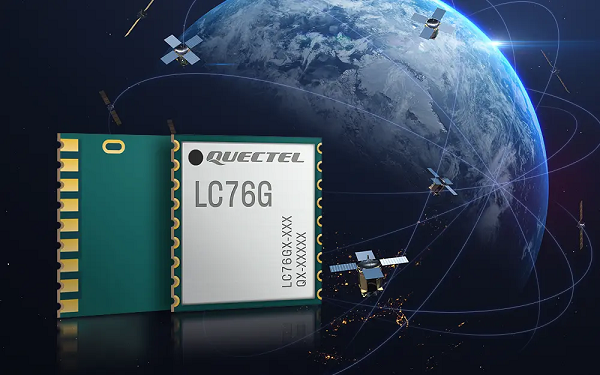
Quectel Wireless Solutions, a global IoT solutions provider, has released the LC76G module, a single-band compact GNSS module featuring fast and accurate location performance as well as ultra-low power consumption.
The LC76G is on display at Embedded World Nuremberg, Booth No 171, Hall 5, June 21- 23.
The LC76G has already entered mass production with sufficient supply to meet the needs of the global positioning market. Based on the Airoha AG3352 platform, the LC76G can concurrently receive and process signals from all four global constellations and the regional QZSS.
The LC76G module can receive signals from up to 47 satellites and achieve 1.5 m (CEP50 open-sky) positioning accuracy representing a 40% improvement over previous generations of devices.
Available in a cost-optimized version as well as a low-power version, the LC76G low-power version consumes less than 9 mA@3V with all four constellations enabled, allowing for a 72% reduction in power required compared to what was previously possible.
This makes the LC76G suitable for battery-operated devices such as wearable personal trackers, wildlife and livestock tracking, toll tags, portable container trackers and a host of traditional markets such as shared mobility and low-cost asset trackers.
Featuring an internal SAW filter and integrated LNA, the LC76G can be connected directly to a passive patch antenna and provides filtering against unwanted interference, ensuring excellent performance even while driving through dense urban canyons.
EPO and EASY improve TTFF
Integrated assisted-GNSS technology Extended Prediction Orbit (Quectel’s EPO) is supported on the LC76G module. EPO reduces the time to first fix (TTFF) with a hot start taking less than 1 second, a warm start within 2 seconds, while the cold start can obtain accurate tracking fixes within 15 seconds. The faster GNSS fixes make it possible to use accurate positioning and navigation services anytime and anywhere with a smaller power budget than previously possible.
While EPO requires manual download of predicted orbits, the LC76G also supports the Embedded Assist System (EASY), where predicted orbit information is collected directly from the satellites and provides for up to three days of accelerated fixes.
Both EPO and Easy are available for each constellation, allowing for faster TTFF and reduced dependency on any particular constellation.
Featuring an LCC form factor and an ultra-compact size of 10.1 × 9.7 ×2.4 mm, the footprint of the LC76G is compatible with other industry solutions as well as Quectel’s legacy L76 and L76-LB modules, allowing for a smooth migration of existing designs to the latest low-power GNSS technology.
In addition, Quectel offers a wide range of off-the-shelf and customized high-performance antennas which boost wireless connectivity significantly. The C76G can be combined with a selection of GNSS L1 antennas to enable various positioning requirements. Customized connector type and cable length as well as comprehensive antenna design and test support are also available.
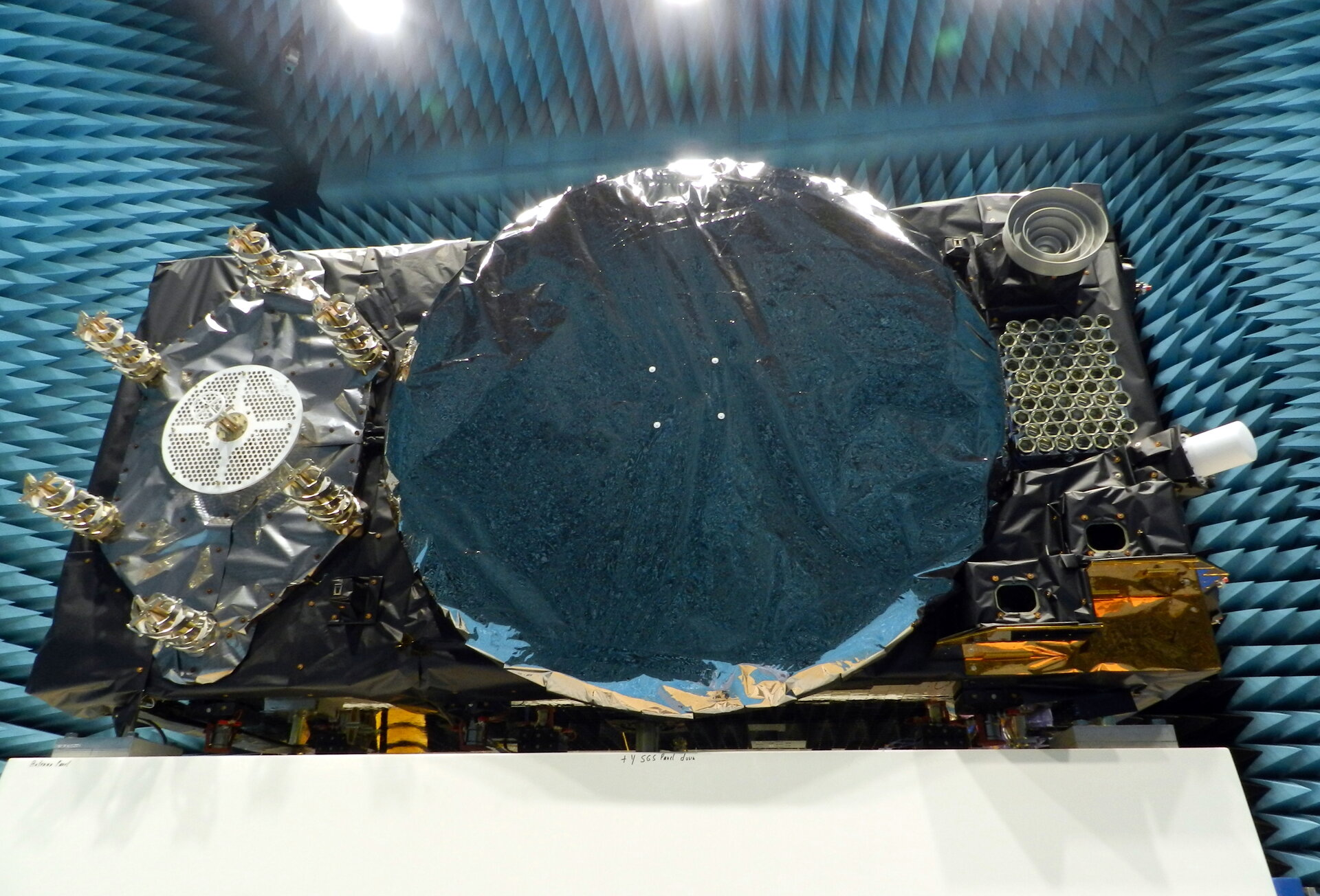
Within ESA’s Maxwell EMC Facility, each Galileo satellite is switched on as if it were already operating in space. The test procedure is a check of the satellite’s electromagnetic compatibility; all its systems are run together to detect any harmful interference between them.
Once Maxwell’s main door is sealed, its metal walls form a Faraday Cage, screening out external electromagnetic signals. The anechoic foam pyramids covering its interior absorb internal signals – as well as sound – to prevent any reflection, mimicking the infinite void of space for satellite testing.
In the photo here, sheathed in multi-layer insulation, the 2.5 x 1.2 x 1.1-meter satellite’s main 1.4-m diameter antenna transmits L-band navigation signals. To its left is the hexagonal search and rescue antenna that will pick up distress signals and relay them to local emergency services, contributing to saving more than 2,000 lives annually.
The Face of Galileo: A Galileo satellite is tested in the Maxwell EMC Facility before heading for space. (Photo: ESA)
To the bottom right of the navigation antenna are a pair of infrared Earth sensors to keep the navigation permanently locked onto Earth by homing in on the contrast between the heat of Earth’s atmosphere and the cold of deep space.
Above them is the laser retro-reflector: lasers are shone up to this from International Laser Ranging Service stations to perform an independent check of the satellite’s orbital position down to an accuracy of less than a centimeter, as a backup of standard radio ranging.
Above that is the circular C-band antenna, which every 45 minutes or so receives the navigation messages from the Galileo ground segment. These signals incorporate corrections for slight clock errors, orbital drift or satellite malfunctions that user receivers can process as they perform positioning fixes, helping ensure Galileo delivers meter-scale positioning to users around the globe.
What resembles a white baton on the end of the satellite is its S-band antenna, employed to return “housekeeping” telemetry data to mission control on Earth and pick up telecommands to operate the satellite platform and payload – as well as performing the ranging used to estimate the satellite’s position in space.
The Maxwell EMC Facility is part of the ESTEC Test Centre in ESA’s technical heart in Noordwijk, the Netherlands – Europe’s largest satellite testing facility, which has flight-tested all but two of the 28 Galileo satellites already in orbit, and is doing the same for the next 10 satellites planned to join the constellation.