WingXpand has debuted a 7-foot expandable-wing drone that fits in a backpack. The drone was first revealed to the special forces community at the Special Operations Forces Industry Conference (SOFIC 2022) held May 16-19 in Tampa, Florida.
WingXpand is U.S. made with a patented design that takes the small size and simplicity of a quadcopter and combines it with the horsepower of an airplane. WingXpand maximizes capability, efficiency and safety for the military and public safety officials. It can also be used by farmers, surveyors and inspectors.
WingXpand expands in less than 2 minutes. Though the full system weighs less than 10 pounds, it flies five times longer and carries ten times more weight than other drones of its size class, according to WingXpand. It can carry high-resolution cameras and other modular payloads such as a real-time pattern analysis system.
WingXpand can reduce or replace the need for more costly, scarce or dangerous options. More than 10 WingXpand UAS can fit in a public safety vehicle, more than 30 in a pickup, and 250 on a standard airlift pallet.
The WingXpand team provides end-to-end services, including pilot services, training, data analysis and sustainment.
Two Belgian adventurers are crossing Greenland on a triathlon including ski, kayak and a vertical rock climb. On the ride, they are using Septentrio’s AsteRx-SB receiver, collecting valuable data for climate research in collaboration with the Royal Observatory of Belgium.
The data will help build a precise elevation profile of the Greenland Ice Sheet as well as to calibrate existing elevation models, which are based on satellite altimetry. In addition, the multi-frequency capability of the AsteRx-SB receiver will enable monitoring of ionospheric activity as well as Galileo signals at high latitudes.
“The AsteRx-SB receiver provides accurate and reliable positioning data even in the world’s harshest environments,” said Nicolas Bergeot of the Time-Ionosphere section, Royal Observatory. Data collected will help research of arctic ice caps, ionospheric activity and other topics.
The expedition is called Nanok, which is an Inuit word for polar bear. Adventurers Gilles Denis and Nathan Goffart started the triathlon with a 600-km ski with a pulk sled along the Arctic Circle. The second part of the triathlon is a 1,000-km sea kayak along the Greenland east coast, and finally a 1-km vertical rock climb.
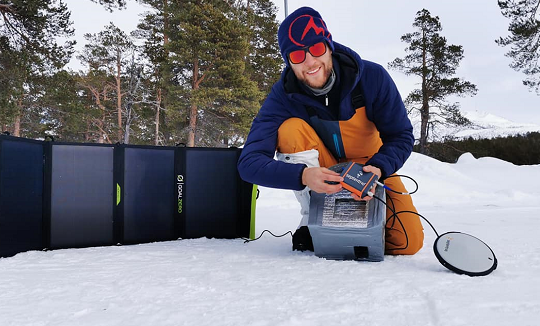
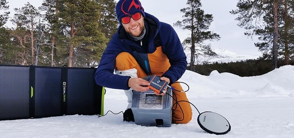
Gilles Denis shows the AsteRx-SB receiver and the PolaNt-x MF antenna that are accompanying the explorers for the entire journey, so that data can be collected at various locations along the way. The receiver is powered by solar panels. (Photo: Nanok Expedition)
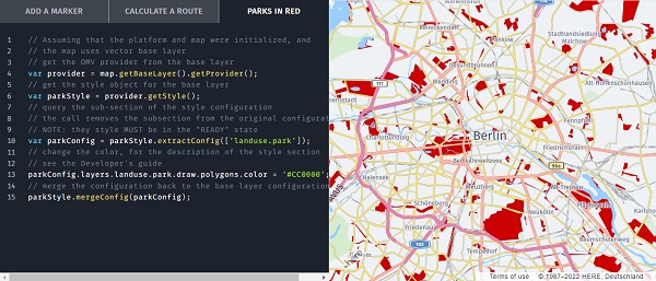
HERE Technologies is collaborating with Amazon Web Services (AWS) to offer developers access to an array of location services through the recently launched AWS Serverless Application Repository.
Through the collaboration, HERE and AWS are increasing the speed and ease in which developers can access and integrate core location services into their applications.
Because HERE location services are available in the AWS Serverless Application Repository, developers can rapidly deploy AWS Lambda into their own AWS account that serve as proxies to HERE location services, and thus allows for a microservices approach to calling the HERE locations services. This approach also provides developers with benefits from Amazon API Gateway and AWS Lambda capabilities such as cache, throttling and authentication.
Developers on the AWS Serverless Application Repository have access to a suite of HERE location services, including:
map images and tiles
geocoding
positioning
routing
road toll costs
road traffic conditions
public transit information
weather conditions.
With credentials from developer.here.com, developers can access the location services on the AWS Serverless Application Repository, now available in Preview.
The partnership will help to grow global adoption of the u-blox PointPerfect high-precision positioning service, in particular for automotive applications.
U-blox and Geespace have signed a memorandum of understanding (MOU) on the expansion of their respective augmentation services for high-precision applications.
Geespace is a provider of aerospace information and communications infrastructure and application solutions. Both partners will be able to extend their service offering to the U.S., European and Chinese markets, primarily in the automotive sector.
The rise of reliable and cost-effective high-precision positioning has improved the accuracy of GNSS solutions to the order of tens of centimeters, enabling a plethora of new applications in automotive, as well as industrial and robotics segments. Global adoption has, however, been hampered by a fragmentation of the augmentation services landscape, thee companies said.
For global adoption to become a reality, worldwide coverage is required, as is unified pricing and business models designed to serve mass-market high-precision solutions for automotive and industrial customers operating on a global scale. The resulting differences in technical specifications have also made development of such solutions requiring different services complex.
The MoU between u-blox and Geespace seeks to create a combined offering that will enable both companies to offer full-stack high-precision positioning software and hardware solutions to customers across the U.S., European and Chinese markets.
Also, it will enable Geespace, which provides automotive GNSS augmentation services to its parent company Geely Group, to use the u-blox PointPerfect GNSS augmentation service to grow its coverage to serve Geely’s automotive brands. Headquartered in Hangzhou, China, Geely Group brands include Geely Auto, Lynk & Co, Zeekr, Volvo Cars, Polestar, Lotus, London Electric Vehicle Company, Farizon Auto and CAOCAO Mobility.
The MOU also will enable u-blox to expand coverage of PointPerfect to offer customers a comprehensive high-precision solution for products sold in China, and benefit from simplified development and logistics efforts.
New GradeMetrix features include knuckle boom and swing boom support
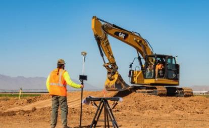
Hemisphere GNSS has expanded the features of its GradeMetrix excavator solutions, adding support for knuckle boom and swing boom excavators as part of its GradeMetrix 3D Excavator solution.
The additional feature sets unlock enormous potential for GradeMetrix excavators, especially in the compact excavator market, according to Hemisphere. “Hemisphere recognizes that machine control technology for compact excavators has been an underserved audience globally,” said Miles Ware, vice president of marketing. “Based on direct feedback from our global machine control partners, and endless hours of testing, we are excited to introduce these options that will further enhance the available ROI [return on investment] for our customers.”
Photo: Hemisphere GNSS
“Hemisphere’s commitment to globally expand the access to machine-control technology continues to be a key component of our growth strategy,” said Farlin Halsey, president and CEO of Hemisphere GNSS. “Our strategy to combine best-in-class GNSS technology, with modern, efficient and intuitive features, further advances our efforts to make machine-control technology available to the global construction community, including such key customers as Iwasaki.”
“The opportunity to introduce a solution that supports excavators equipped with knuckle boom is a very important achievement for our organization,” said Satoshi Furuguchi, CEO of Iwasaki Co. Ltd. “Iwasaki and Hemisphere have a great partnership, and we look forward to empowering additional productivity solutions together.”
Hemisphere will make knuckle boom and swing boom options available in several of its new GradeMetrix excavator kits. Existing GradeMetrix excavator customers will have an option to add this feature to their current systems via an additional cable and sensor package available from an authorized GradeMetrix dealer.
Hemisphere GNSS is exhibiting at the Construction & Survey Productivity Improvement Expo in Chiba, Japan, at booth E-11.
FAA TSO-C190 authorization makes multi-platform anti-jam GPS navigation antenna (MAGNA) systems available for both military and commercial aviation use
MAGNA-F anti-jam system. (Photo: Mayflower)
Mayflower Communications Company Inc. has received technical standard order Mayflower Communications (TSO-C190) authorization from the U.S. Federal Aviation Administration (FAA) for both models of its MAGNA GPS anti-jam product.
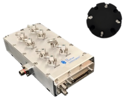
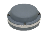
Mayflower’s MAGNA GPS anti-jam products — MAGNA-Federated (MAGNA-F) and the MAGNA-Integrated (MAGNA-I)— can be installed on both military and civilian aircraft. Both MAGNA products offer simultaneous L1/L2 protection and can protect commercial and military GPS receivers.
Mayflower’s MAGNA products build on Mayflower’s SWaP-optimized GPS anti-jam antenna technologies, which are optimized for small size, weight and power (SWaP), including small antenna systems. The MAGNA products were developed with sponsorship by the U.S. Navy SPAWAR and further improved under the U.S. Army PEO AVN to support GPS protection requirements for SWaP-constrained air, sea and ground platforms, such as fixed-wing/rotary aircraft, ships, UAVs and tactical vehicles.
MAGNA-I anti-jam system. (Photo: Mayflower)
The MAGNA-F (NavGuard 710) has been extensively integrated, tested and flown in navigation warfare (NAVWAR) operational environments by the U.S. government on multiple aircraft platforms. MAGNA-F is the highest performance and smallest federated GPS anti-jam solution on the market in its class, utilizing a 3.5-inch diameter controlled reception pattern antenna (CRPA) compatible with existing fixed radiation pattern antenna (FRPA) footprints.
The MAGNA-I (NavGuard 730) is a high-performance yet small GPS anti-jam integrated solution on the market, with a 4.5-inch diameter FRPA-compatible footprint. MAGNA-I simplifies platform integration and reduces lifecycle costs. The MAGNA-I integrated anti-jam solution (antenna array integrated with antenna electronics in a single module) is designed for platforms with difficult integration challenges.
“The MAGNA GPS protection system provides pilots with improved GPS availability in a global environment with disrupted GPS signals,” said Triveni Upadhyay, Mayflower’s founder and president.
Mayflower Communications management team will be participating in the upcoming Joint Navigation Conference (JNC).
Mayflower Communications is exhibiting its MAGNA suite of products at booth #216 at ION’s 2022 Joint Navigation Conference, which takes place June 6-9 in San Diego, California. Also at the conference, Naresh Jarmale, Mayflower vice president of engineering, will present a paper during Session B4: Military PNT User Equipment 2 – EGI and Platform Integrated PNT.
We all need to be careful that the numbers we are throwing around to support our case aren’t really undermining it.
Dana Goward, President, Resilient PNT Foundation
Over the last several weeks, I have repeatedly heard government officials and others talking about the value of GPS to the U.S. economy.
In each case they cited a 2019 report sponsored by the National Institute of Standards and Technology. It determined that, if GPS services were to go away, the U.S. economy would lose one billion dollars a day.
A billion dollars is a lot of money.
Yet the U.S. annual gross domestic product is more than $22 trillion a year. That’s more than $60B a day. One billion dollars is less than 1.7%.
That just doesn’t seem right.
A member of the White House’s National Security Council said “GPS is still a single point of failure” for America. That sounds like a pretty big hit to the economy. Not to mention our national security.
GPS signals are critical for networks, transportation, communications, power grid operations, first responders…virtually every critical infrastructure. If they go away, the U.S. GDP will certainly suffer much more loss than 1.7%. The economy would likely go from growing to shrinking and continue that way for quite a while.
I don’t know exactly how much the U.S. will suffer if GPS suddenly goes away, but I am sure it will be a lot. Texas alone lost an estimated $195 billion with at least 57 dead as a result of its February 2021 week-long power crisis. Although not caused by a GPS outage, the number gives us real-world benchmarks for the impacts of a major tech infrastructure failure.
If GPS fails, there will certainly be more accidents while people across the nation get used to it not being available. First responders will have a much harder time getting places and using land mobile radios. All kinds of essential services will be disrupted. More people will die than would have been the case otherwise.
In December 2021, a member of the White House’s National Security Council said “GPS is still a single point of failure” for America. That sounds like a pretty big hit to the economy. Not to mention our national security.
The authors of the NIST-sponsored study were undoubtedly diligent. But they were faced with an impossible task – to quantify the unquantifiable. And like any analysis, they were limited in what they could do by the available time, money, and hard data. They were asked for a number. They delivered one that could be easily supported.
A billion dollars is a lot of money. It might be a fairly impressive sound bite for general audiences.
Government budget analysts and policy makers, though, are accustomed to dealing with dollars in the hundreds of billions and trillions. A billion a day, while not chump change, is not a major issue.
Protecting GPS and ensuring the nation has resilient positioning, navigation and timing services are major issues.
We all need to be careful that the numbers we are throwing around to support our case aren’t really undermining it.
Dana A. Goward is president of the Resilient Navigation and Timing Foundation.
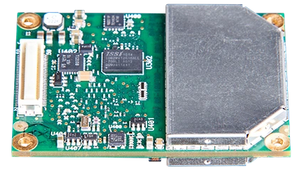
Topcon’s ultra-compact B111A GNSS receiver board can provide scalable positioning from sub-meter differential GPS to sub-centimeter real-time kinematic (RTK) positioning. The board’s flexible design — low power consumption, comprehensive communication interfaces and peripheral support — make it easy to integrate the B111A into any precise positioning application, Topcon said.
Besides in surveying and mapping, survey drones are now used in a broad spectrum of applications ranging from construction and mining to agriculture and environmental monitoring.
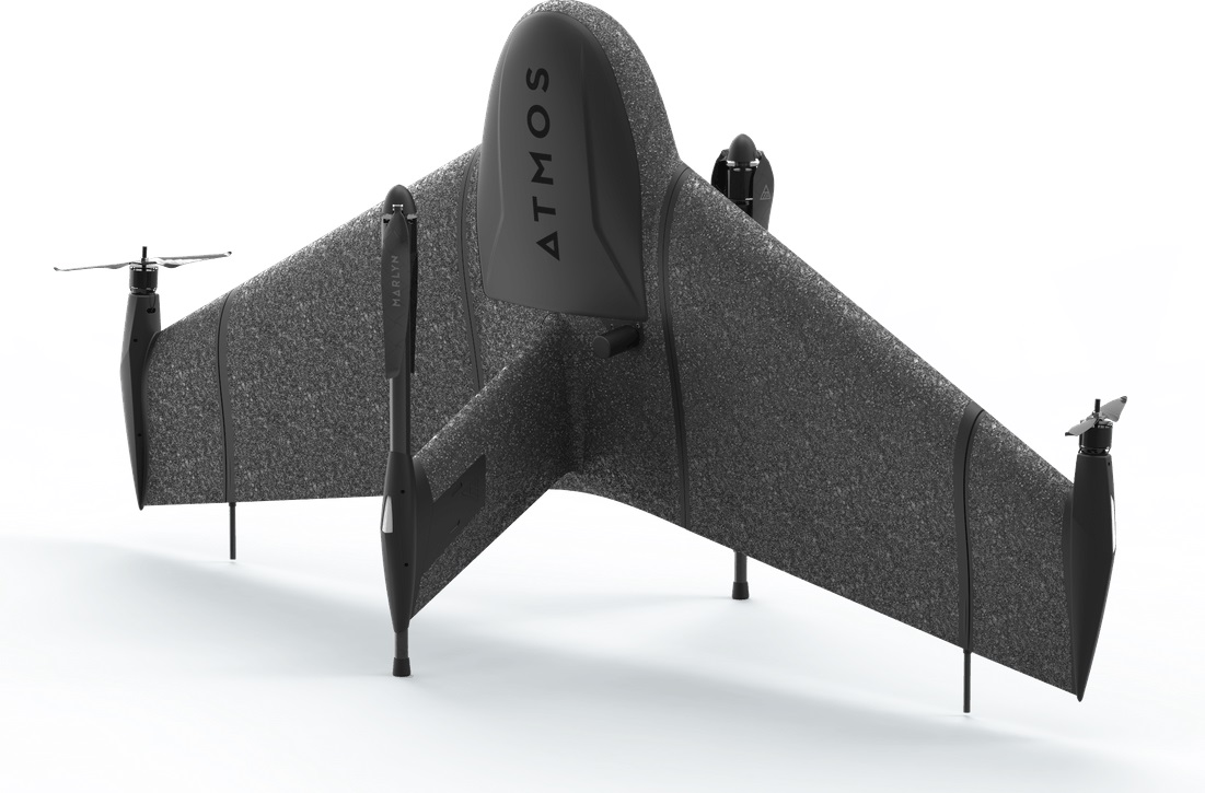
The Atmos Marlyn Cobalt is a vertical-takeoff-and-landing (VTOL) fixed-wing mapping drone developed by Atmos with the goal of allowing users to effortlessly collect accurate geospatial information and turn it into actionable insights. “Our mission is to provide professionals with the tool with which they can plan a better future with precision,” said Ruud Knoops, Atmos CEO.
To provide precise positioning accuracy, a GNSS board needs to compensate for inaccuracies caused by satellite constellations, receiver hardware and atmospheric conditions.
The use of Topnet Live — Topcon’s GNSS real-time correction service — provides high-accuracy positioning and survey-grade results to professionals through a 24/7 cross-border, consistent and reliable access. The combination removes the need for base stations, increasing efficiency leading to higher productivity and decreased costs.
The INTERGEO Expo & Conference focuses on innovations for a smarter world. INTERGEO 2022 will take place October 18-20 in Essen, Germany.
Topics including the importance of geoinformation for internal security, monitoring for disaster control and prevention, open data, digital twins alongside their use in construction and housing, mobility, sustainability and climate change, BIM and engineering applications with UAV, laser scanning and monitoring will be discussed during the 2022 event.
Additionally, the outdoor area of Messe Essen will show live demonstrations of the latest UAV applications in surveying, agriculture, construction, security and many more.
According to INTERGEO organizers, 300 international companies are already registered at the Expo, from innovative young start-ups to international key players such as Autodesk, Esri Inc., Hexagon, Trimble, Topcon and many more. The organizers expect around 500 exhibitors by October.
“All the international key players in the industry will be there.There was no doubt about it – they all want to get back to their customers, to visitors, to the live atmosphere and the power of meetings”, says Prof. Dr-Ing. Hansjörg Kutterer, President of the organiser DVW e.V., Association for Geodesy, Geoinformation and Land Management.
For those who are unable to attend the event in Germany, there will be some opportunities to participate in the Expo remotely.
Up close and personal
Digital Twins will receive their big break at the Conference 2022. Their use in building information modeling, smart planning and construction as well as mobility will be the focus of the event. Digital twins will be used to further development of urban data platforms in the context of smart cities and their variety of applications, as well as the use of smart city solutions in terms of innovation and sustainability and a basis for predictions and scenarios in the event of disasters.
The main topics in 2022 are Digital Twins and their value creation, 4D geodata and Geospatial IoT, potentials of remote sensing, BIM 4.0, industrial surveying, measurement systems and robotics, smart cities and mobility in the context of climate change and sustainability, mobile mapping, web services and GeoIT in disaster relief, spatial reference and positioning, earth observation and Galileo.
Hansjörg Kutterer points out the high innovative power of the industry: “We are experiencing high dynamics in segments such as mobility, environment and sustainability, climate protection and urbanization. Geo-IT has positioned itself as a solution provider for these topics. Problem-solving without Geo-IT is unthinkable in these subject areas. Come to Essen on the 18th to 20th of October and visit Intergeo Expo and Conference.”
How to attend
Tickets for INTERGEO are now available. An early-bird registration rate is available until August 31. Tickets can be found at https://www.intergeo.de/en/tickets.
Registration for new exhibitors is open as well. All information, such as application procedures and funding amounts, can be found on the INTERGEO website at www.intergeo.de/en/.
The 6th Unmanned and Autonomous Systems for Utilities & Energy Conference will take place in Atlanta, GA on June 8-9, 2022.
The event aims to provide a platform for UAS professionals to gain insight from industry peers and regulatory bodies on best practices in pilot training, safety in inspections, data management and security, updates on Part 107, new UAS technologies, and other key issues for utilities.
The conference also includes discussions on alternatives to foreign-made drones, BVLOS waivers and use cases, a closer look at LiDAR and AI, and building and refining drone programs to boost efficiency and reliability. Attendees will learn how they can navigate through industry challenges by leveraging emerging technologies and improving existing strategies to boost operational success.
Join the event to learn how you can navigate through industry challenges by leveraging emerging technologies and improving existing strategies to boost operational success.
Those who are unable to attend in person have the option to attend virtually. The Live+ content platform will give you access to all the presentations and is loaded with features to ensure full participation.
AUVSI members are entitled to a discount on full price conference fees (not valid for solution providers).
For registration information, cost and any discounts that may apply please contact:
Ria Kiayia
Digital Media & PR Marketing Executive [email protected]
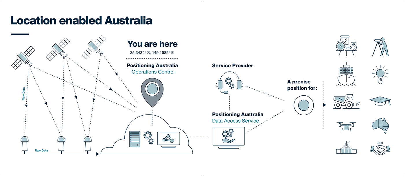
NPIC is key to a location-enabled Australia. (Image: Geoscience Australia)
Geoscience Australia is undertaking an assessment of the economic impact of the National Positioning Infrastructure Capability (NPIC) program.
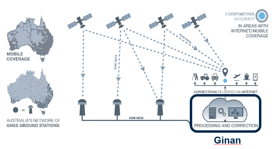
The program provides free and open access to multi-GNSS observation streams from Australia’s network of continuously operating reference stations (CORS).
Users can connect to these data and product streams directly from Geoscience Australia or via a commercial positioning-service provider. The CORS network has been designed to support a national positioning capability that provides better than 5-cm accurate positioning solutions in areas with access to mobile-phone coverage (delivery via the internet).
Geoscience Australia has engaged ACIL Allen to conduct a web-based survey for stakeholders with interest in this program to assist with data gathering for the economic assessment.
The survey takes 15 to 20 minutes to complete. There is an additional optional component for service providers that may take an additional 15 minutes.
It can be completed in stages, if necessary, with a facility to save responses. It will remain open until June 28 (extended from May 25).
Questions can be directed to Alan Smart (project director) at 0404 822 312 or Nanumi Starke (ACIL Allen) at 0466 636 345.
Septentrio has taken a step toward simplifying the integration process of its GNSS receivers that include inertial navigation systems (GNSS/INS). Its new RxLeverArm software tool aids GNSS/INS installation and improves accuracy, with automatic optimization of lever-arm settings.
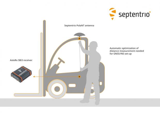
RxLeverArm is now part of Septentrio’s RxTools software package included with every Septentrio GNSS/INS receiver. This new tool visualizes, validates and automatically calibrates the exact distance between the INS sensor and the antenna, removing the need for accurate distance measurements with complex instruments.
GNSS/INS receiver setup is significantly simplified with RxLeverArm functionality, which enables users to start testing minutes after receiver installation. (Image: Septentrio)
“We are focusing our design around easy, efficient and effective INS installations ensuring short time-to-market and accurate deployment for our customers,” said Danilo Sabbatini, product manager at Septentrio.
“The RxLeverArm tool in combination with the intuitive web user interface, as well as the support material available in our knowledge base, enables customers to start testing within minutes after the physical installation of their receiver,” Sabbatini said.
For lever-arm compensation, users now only need to measure the rough distance between the inertial measurement unit (IMU) and the main GNSS antenna reference points on the vehicle. Data is then logged under open-sky conditions, which allows the RxLeverArm tool to optimize the initial rough distance measurement and prevent common errors such as sign inversion.
The result is simplification of the installation process and better accuracy of the lever-arm measurement.