Arianespace will launch eight additional Galileo satellites, confirmed the European Union Agency for the Space Programme (EUSPA).
Arianespace will launch the first two satellites in 2022, leading to the Full Operational Capability of Galileo open service. Then, three successive launches on Ariane 62 in 2023, 2024 and 2025 will finalize the launch of the first generation of Galileo satellites and will increase the constellation resilience.
These will be the 13th to 16th Galileo missions by Arianespace, which has orbited all satellites in the constellation.
With this order, EUSPA takes over the role of placing launch services contracts for Galileo from the European Space Agency (ESA), which has acted so far in the name and on behalf of the European Commission and will continue to be the technical authority for these launches.
The order follows ESA’s order for the launch of four satellites in October 2021, and will complete the deployment of first-generation Galileo satellites.
The launches will take place from the Guiana Space Center, Europe’s Spaceport in Kourou, French Guiana. After a Galileo launch in the first half of this year, carrying satellites from a previous order, a second Soyuz launch this year will orbit the first two satellites from this latest order. The next three missions will orbit two satellites each on Ariane 62.
“I would like to thank ESA and EUSPA, along with the European Commission, for continuing to entrust us with their satellites,” said Stéphane Israël, CEO of Arianespace. “We’re very proud to once again be helping the EU deploy its own global navigation satellite system. This additional order to the service of Galileo once again confirms Arianespace’s assigned mission of ensuring reliable access to space for Europe.”
Each of the eight satellites under this order, built by OHB System AG in Bremen, Germany, will weigh less than 730 kg. They will join the 28 Galileo satellites already deployed to date, as well as the two to be orbited in early 2022 from the Guiana Space Center by Arianespace.
The Galileo Open Service Definition Document (OS SDD) was updated to reflect upgrades in the Galileo system since the publication of the previous version in May 2019. The latest version, 1.2, can be found on the GSC web portal.
This is the last update foreseen before Galileo Open Service reaches Full Operational Capability (FOC).
The SDD has been updated to include improvements of the Open Service, accounting for the current constellation and updates in the ground infrastructure that increase its robustness.
The updated SDD provides better minimum performance levels (MPLs) for signal and position availability and updated definitions of some timing MPLs. It also establishes a more stringent commitment on the time to publish Notice Advisories to Galileo Users (NAGUs). In addition, the concept of auxiliary satellites has been added, while some sections have been reworded to improve clarity.
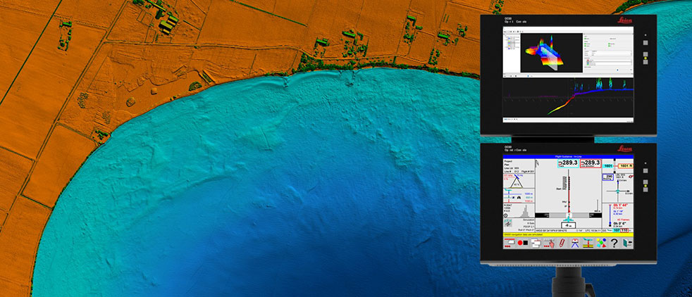
Leica Chiroptera 4X bathymetric data with Leica OC60 screen visualizing objects in near real-time during the flight. (Photo: Hexagon)
Hexagon is partnering with Airbus on a near-real-time airborne bathymetric lidar surveillance system.
Hexagon’s Geosystems division is partnering with Airbus to integrate two Leica Chiroptera 4X bathymetric lidar sensors for maritime surveillance into the C295 MSA, Airbus’ Maritime Surveillance Aircraft.
Hexagon’s new technology enables detection of underwater objects in near real time, a significant innovation in the airborne bathymetry industry, the company said.
The lidar system was developed to meet Airbus’ requirements and will first be implemented in two C295 MSA craft purchased by the Irish Air Corps. The aircraft are due for delivery to Ireland in 2023.
The system’s unique object-detection feature enables real-time lidar data visualization and analysis during flight. Being able to locate the precise position of an object allows operators to preview and analyze information captured below water immediately — a process that previously could take several days.
“When we acquired the C295 MSA, we explored various sensors to be added to our fleet, including bathymetric and topographic LiDAR. Airbus introduced us to the Chiroptera 4X, which now meets all our requirements,” said Stephen Connolly, captain of the Irish Air Corps. “The combined bathymetric and topographic lidar sensor will provide us with more details than ever before. Detecting objects close to real-time and having a clear picture of underwater activities will allow us to report directly to the Mission Support Centre on the ground and act faster to perform our duties more efficiently. The Chiroptera 4X will provide an overall better solution for the coastal maritime domain.”
Airbus and Irish Air Corps visited Hexagon’s R&D and production facility in Jönköping, Sweden, in September for the factory acceptance test. (Photo: Hexagon)
Infineon Technologies AG and Deeyook are collaborating on location solutions. Deeyook, a location-as-a-service (LaaS) company, has patented a tracking solution to determine indoor and outdoor locations of items, assets and employees.
The companies fused Deeyook’s ultra-precise algorithms into Infineon’s low-power AIROC Wi-Fi portfolio to enable an accurate, passive, ubiquitous and efficient location solution.
Deeyook specializes in wireless signal processing applicable to incumbent Wi-Fi/4G/5G modem firmware versions. The firmware extracts angles of wireless transmissions (direction finding, or DF), for commercial wireless tracking. Deeyook’s tracking capabilities are ultra-precise, providing location information within 10 cm/4 in, passively exploiting the install base of 1.7 billion wireless access points worldwide.
“There are many challenges when companies implement real-time location systems, primarily because tracking solutions, such as RFID, are not really ubiquitous. This is particularly acute with GPS, which has many shortcomings,” said Gideon Rottem, CEO and co-founder of Deeyook. “We created Deeyook to address these challenges — technology that is ubiquitous and can track things with the utmost precision indoors, outdoors and in bad weather. We are excited to work with Infineon because its AIROC Wi-Fi portfolio is reliable and power efficient.”
“Infineon’s mission is to make the world an easier, safer and greener place with our technologies through smart, connected devices,” said Sivaram Trikutam, senior director, IoT Compute and Wireless, Infineon Technologies. “These new IoT solutions support multiple location tracking technologies. Previously, Wi-Fi was not considered a viable option due to its power demands, while additionally, real-time locating system (RTLS) deployments required businesses to utilize custom solutions with costly infrastructure, engineering and labor-intensive installation.”
Aceinna Inc. has announced the INS401 INS and GNSS/RTK, a turnkey solution for autonomous vehicle precise positioning. Aceinna made the announcement at the Consumer Electronics Show (CES) taking place this week in Las Vegas.
The INS401 is part of Aceinna’s new product portfolio that provides high accuracy and high integrity localization for developers and manufacturers of advanced driver-assistance systems (ADAS) and autonomy solutions for vehicles of all types.
The INS401 is a high-performance inertial navigation system (INS) with a dual-frequency GNSS receiver enabled with real-time kinematic (RTK). It also features triple-redundant inertial sensors and a positioning engine. It is designed for use in Level 2 and higher ADAS and other high-volume applications requiring precise position information.
The INS401 provides centimeter-level accuracy, enhanced reliability and superior performance during GNSS outages. The dead-reckoning solution delivers strong performance in GNSS-challenged urban environments.
The INS401 is specifically developed for automotive applications using automotive-qualified components and is certified to ASIL-B level according to ISO26262.
INS401 is small, compact and turnkey with a rugged aluminum housing. It includes everything needed for design and development of a robust navigation system with a flexible platform enabling easy customization for fast time to market. The included integrity engine guarantees zero performance failure.
“Based on a decade-long history in ADAS and safety applications, Aceinna is ready for today’s and future autonomous mobility applications,” said Wade Appelman, president and COO of Aceinna. “The INS401 is our next step forward, delivering complex INS/RTK technology to mass markets with turnkey products.”
Quectel Wireless Solutions has launched the SG865W-WF, a new generation of flagship Android smart module. The module is equipped with Qualcomm’s QCS8250 system-on-chip (SoC), which offers powerful performance and rich multimedia functions to meet industrial and consumer artificial intelligence IoT (AIoT) scenarios.
Quectel made the announcement at the Consumer Electronics Show (CES) taking place this week in Las Vegas.
With various peripheral interfaces such as dual USB, multiple PCIe and UART, the product can seamlessly integrate with cellular and GNSS modules such as Quectel’s EC20 LTE module, and the RG500Q 5G module, allowing customer terminals to be connected flexibly to 4G/5G networks and achieve faster and more accurate positioning.
The SG865W-WF module will accelerate the efficient deployment of high-end AIoT applications such as video conferencing, cloud gaming, digital signage, unmanned aerial vehicles (UAVs), robots and smart retail.
TerraStar X corrections technology enables lane-level accuracy with under one-minute convergence for consumer and automotive-grade GNSS receivers
Hexagon’s Autonomy & Positioning division has partnered with Chinese positioning company Dayou to bring TerraStar X technology to the Chinese market. TerraStar X provides fast precise point positioning (PPP) corrections for autonomous vehicles and has mass-market use such as in smartphones.
The partnership enables Hexagon and Dayou to provide consistent positioning solutions globally, including North America, Europe and China, so original equipment manufacturers (OEMs) can deploy the same design worldwide.
The GNSS corrections generated from TerraStar X technology enable lane-level accuracy with convergence in under a minute for consumer and automotive-grade GNSS receivers, supporting advanced driver-assistance systems (ADAS), autonomous applications, safety-critical applications, mobile-phone applications and more.
TerraStar X technology delivers corrections using industry-standard formats compatible with mobile networks and enabling efficient delivery of corrections to millions of end-user devices. Through the partnership with Dayou, OEMs can now deploy the same high-accuracy solution across China as in North America and Europe, while having access to local sales, support and technical resources.
“This partnership provides a way for global companies to leverage TerraStar X technology to bring consistent lane-level positioning around the globe,” said Sara Masterson, director of positioning services at Hexagon’s Autonomy & Positioning division. “With its hardware-agnostic design, industry-standard format and delivery of corrections, this technology opens up the possibility of precise positioning for a multitude of new mass-market applications for customers to use one software positioning solution on all platforms worldwide.”
“Dayou is excited to be working with Hexagon in China to bring this next level of positioning technology to market,” said Han Jianxin, chief executive officer at Dayou. “High accuracy positioning used to be limited to expensive equipment and niche markets like survey and mapping. With TerraStar X technology, everyone can have the benefit of more accurate positioning, opening up new applications ranging from autonomous driving and freight to regular smartphone users moving from point A to B.”
Test Regions Expand to China
Using Dayou’s local infrastructure to calculate ionosphere corrections, TerraStar X technology ensures that fast convergence to lane-level and sub-meter accuracy is available when needed.
Engineering development test areas are available around the world to support large-scale programs with functional safety requirements. With these test regions now expanded to China, the partnership with Dayou marks a significant milestone to bring Hexagon’s TerraStar X technology to a global scale.
China Dayou PI is a Chinese company invested in by China Intelligent and Connected Vehicles (Beijing) Research Institute Co. Ltd. for high-precision positioning service and solutions based on GNSS, INS and HD map technology.
Tim Burch is a contributing editor to GPS World’s Survey Scene newsletter, authoring columns six times a year.
Burch is a professional land surveyor (PLS) licensed in Illinois and Wisconsin. He has been involved with NSPS for more than 20 years as secretary of the board of governors as well as the board of directors, NSPS vice president, a member of the Certified Survey Technician Board, Joint Government Affairs and American Land Title Association (ALTA)/NSPS Land Title Survey committees. Along with content contributor for NSPS social media, he is creator and producer of the NSPS podcast “Surveyor Says!” and a contributing writer to the NSPS newsletter “News and Views.”
Burch has been involved with the land surveying profession for more than 30 years and has represented NSPS at numerous functions and conferences. He has provided testimony on behalf of the profession at both the state and federal levels as well as helping establish a partnership with “Get Kids into Surveying.”
He is currently chair of the International Federation of Surveyors (FIG) Working Group 1.1 (Professional Ethics) and is chair-elect for FIG Commission 1 (Professional Standards).
Burch succeeded Curt Sumner, who was executive director for the past 23 years.
Another year has come and gone. The global pandemic of COVID-19 is still upon us, and while we have experienced peaks and valleys of controlling the virus, it has radically changed our lives in many ways.
The surveying and geospatial professions have not been immune to the effects of the pandemic. It has forced many practitioners to modernize the means and methods to their workflows and products.
In this edition of Survey Scene, I consider the changes and accomplishments of 2021, and take a look ahead at events and technological advances to come.
2021: The Road We Traveled
Despite the pandemic, technology within the geospatial professions grew at a rapid pace, with new equipment and features. From the air to the seas, geospatial data-collection capability increased in varying ways across the differing environments.
Unmanned Aerial Systems (UAS)
The technological explosion of unmanned aerial vehicles (UAV) shows no signs of slowing down and manufacturers remain hard at work developing new designs for longer flights and increased capabilities. Lidar has emerged as the “hot” remote-sensing method for many users of UAS as an additional tool for photogrammetric capabilities, yet camera specs continue to grow well beyond the 20-megapixel expectation of recent years. These increased capabilities were not possible simply because of the amount of data generated by the methods, but previous issues and limitations with computing power and data storage have turned a significant corner in software performance and affordability.
In addition to the implementation of lidar, further developments in multirotor and fixed-wing UAV design continue to improve the performance and capabilities of the data-collection task. Many companies are growing their fleets to include both types of UAVs for varying conditions and applications.
Unmanned Ground Vehicles (UGV)
The sector with the most surprising developments has to be the unmanned ground vehicle (UGV) — but not for the reasons most would have predicted. We have been introduced to several products based upon remote-control vehicles utilizing GNSS positioning over the past few years, so it was expected for that trend to continue and grow.
To say the industry was taken aback when Leica partnered their BLK scanning technology with the Boston Dynamics new robot “Spot” would be an understatement. Trial projects and testing is ongoing, but the concept of autonomous data collection by a robotic “dog” is an intriguing concept, especially in environments where human presence is dangerous.
Unmanned Surface Vehicles (USV) and Unmanned Underwater Vehicles (UUV)
The last two autonomous vehicles used by geospatial professionals saw significant advancements as well, and are seeing increased use for many water-based remote-sensing projects. For many bathymetric surveyors, the small-footprint unmanned boat using GNSS positioning and conventional fathometer has been a game changer.
In addition to not investing large sums in a conventional boat, a USV is able to navigate many places and shallower depths than its larger counterparts. Like its airborne and ground cousins, battery life and advancing designs are creating more capability for data collection and remote sensing. The old saying “the sky is the limit” for emerging technologies does not apply to unmanned vehicles, as their use is being seen in almost every environment.
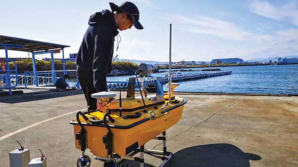
Weichao Liu, a member of CHC Navigation’s technical support staff, prepares to launch an Apache 6 USV. (Photo: CHC Navigation)
Professional Societies/Events/Education
As the calendar pages turned from 2020 to 2021, our world had begun a slow ride back to normalcy with the introduction of several variations of a vaccine for COVID. Some communities chose to return to face-to-face meetings, while others remained cautious and continued with remote communications. Here is a recap of how various organizations remained active within the professional community:
National Society of Professional Surveyors (NSPS) and its state affiliates: In-person resumption for some, while most continued with hybrid and/or remote communication methods.
International Federation of Surveyors (FIG). Annual working week was held remotely.
Council of European Geodetic Surveyors (CLGE). Various meetings held in-person and remotely.
Global Surveyors Week. Hosted by CLGE and held remotely.
NGS Seminars. A variety of seminars throughout the year held online.
Survey & GIS Summit. Joint conference hosted by NSPS and URISA held online.
Intergeo. Return to in-person with hybrid option.
Educational institutions worldwide struggled with returning to in-person classes, yet technology has allowed for remote communication and continued teaching. While many may still see remote learning as a hindrance, improved technology and communication methods have allowed us to continue to learn, work and simply converse with others. Without these tools, life as we know it would be impossible.
Legislation and Government
While much of the attention within legislative arenas was on social and economic issues, the geospatial community continues to monitor several items that potentially have a large impact on the profession.
The continuing saga of Ligado (formerly known as LightSquared) is still playing out, despite the outcry by many industry users of GPS technology. The Federal Communications Commission (FCC) authorized Ligado to begin construction of its new 5G communications technology and denied any stays to this order. Many groups, including coalitions of geospatial data users, continue to protest the authorization by the FCC.
In December 2021, the airline industry, along with Boeing and Airbus, expressed its concerns over the implementation of the new communication technology and the potential interruption of GPS and radio guidance for aircraft. Only time will tell if efforts to derail the installation and use of the new 5G communication band will be successful
Elimination of the professional license requirement for surveyors is quite dangerous and foolish.
Another large issue on the horizon for surveying and geospatial professionals is licensure deregulation. Currently, each state in the U.S. is responsible for licensing and oversight of professionals as established within their statutes. Several consumer groups have begun to petition a number of states to eliminate licensing as a barrier to entry into a given profession, including surveying. They also cite the cost of regulating the professions as an unnecessary expense to the residents of their states.
Unfortunately, these groups are shortsighted about the education and training required to become licensed within each profession to protect the public they serve. While the costs associated with purchasing the technology needed for the profession continues to decline, the expertise and training needed is on the rise. Elimination of the professional license requirement for surveyors is quite dangerous and foolish.
2022: The Road Ahead
As we look ahead, we are still facing many challenges left over from the past few years. Obviously, the COVID-19 pandemic will continue to twist and turn with new variants, enhanced vaccines and adjustments to many aspects of our lives. Because of technology and much different lifestyles from earlier pandemics, we are continuing to adapt to environmental changes: much of business goes about as close to “normal” as possible.
One could say that creativity and innovation has increased because of the pandemic and probably not get much of an argument. So where do we see technology and the geospatial profession heading during 2022?
Technology Evolution
More people are using technology and computing power than ever before and in ways probably not considered even 10 years ago. Until recently, data — especially personal information —has been considered off-limits for public consumption. Only governments were allowed to obtain scores of data to help keep track of literally everything.
Once geospatial technology came along, the game changed to include a location or positional component to a dataset. Now data can be saved to include a place and time for a particular piece of information if necessary.
Databases continue to grow with computing and software enhancements, storage increases and expanded network capability. So where are all of these cutting edge technologies taking the surveying and geospatial professions? Here are ways that continuing technological improvements are advancing our capabilities.
Open-Source Data
While in the past data was typically considered proprietary, many of the datasets used by geospatial professionals do not contain personal information. This information is simply physical location data for improvements and infrastructure that can be shared openly with no risk of compromising personal security.
Examples of open-source data cover many subjects, including shape files of physical objects, lidar and contour data of existing topography, and aerial imagery of the world we live in. It can also include data such as traffic counts, air-quality reporting and general population data.
Much of this data is secured using public funding, but it is not able to be readily shared because of database size limitations. Increases in technology have allowed this information to be shared more freely, and that has given professionals more information in which to better design infrastructure.
Artificial Intelligence (AI) and Machine Learning
Trainable technology is nothing new, but the computing power behind it has rapidly increased to make it a formidable challenge to our future workforce. Besides robotic machinery, sophisticated software is being developed to analyze various datasets and electronic mediums to “learn” about the information it contains.
For example, AI is being used to analyze photographic imagery and lidar datasets to determine characteristics of various elements within the work product. The software can now establish a painted parking line and draw a vectorized line in all places where it finds the same pixelated areas.
This same process is used to determine curbs, buildings and other improvements with an efficiency of which the human surveyor on the same site isn’t capable. While not foolproof, the technology has great potential and can shrink production time drastically. As programming continues to become more robust in determining the computer’s abilities, we should not bet against this market sector achieving anything but rapid growth. Couple these advancements with the shrinking workforce, and we will continue to see much more from this technology.
High-Performance Computing via Cloud Networks and Storage
Before the personal computer (circa 1980), most data processing was completed on a mainframe using terminals and primitive networks. No true computing brainpower was sitting on the user’s desk; the keyboard and monitor were simply conduits to the main processing computer typically housed in a large room somewhere in the building.
Fast forward to today’s environment, in which everything can be considered a computer. As many have noted, your current smartphone has more computing power than we used to reach the Moon. (The Apollo guidance computer had 4 KB of RAM and a 32-KB hard disk; it measured 24 x 12 x 6 inches and weighed 30 kg). Computing power at your fingertips has never been greater, but our improving technology is making today’s current data analysis seem like child’s play.
Enter the world of cloud computing and storage. If you live in a major metropolitan area, you have likely been witness to nondescript buildings being constructed with lots of transformers and electrical grid units surrounding them. These facilities are data centers and are being built at breakneck speed by Google, Microsoft, Facebook, Amazon and others to provide cloud computing and storage for the masses.
The cloud computers offer unmatched processor speed, nearly unlimited storage and reduced IT management costs. Large datasets being analyzed for specific algorithms can utilize cloud computing at a fraction of the cost of maintaining a personal computing system and network. It also allows the flexibility to work from literally anywhere in the world, yet have a consistent computing presence where you are. The big downside is that one is dependent on a reliable (and fast!) connection, as well as needing a comfort level with someone else having access to your data.
Other major areas of technology that will see improvement this year include 3D visualization (AR & VR), remote sensing, massively online open courses (MOOC) for higher learning, blockchain utilization, and an increase in the number of devices using internet of things (IOT) programming. The key to staying in front of these technologies is to remain curious and never stop learning!
A Personal Note for 2022 and Beyond
Like many jobs in this age of advancing technology and automation, surveying is quickly becoming an endangered profession. There are many facets in our everyday lives that are the responsibility of a surveyor, but the number of practitioners is dwindling. The pandemic may have turned our world upside down for many reasons but for surveyors and geospatial professionals, it increased our visibility and workload. Attrition will claim many within our ranks over the next several years, so we must find a way to prolong our profession through all avenues.
Tim Burch
With this in mind, I am proud to announce my appointment as the new executive director of the National Society of Professional Surveyors (NSPS). My years in the private sector have provided me with a broad view of where we face professional challenges, so transferring into an advocacy role will allow me to help solve those challenges.
It will be my honor to work with our organization to recognize the threats lying ahead, not just for surveyors but for many other geospatial professions and occupations. We also recognize that inclusion is a key component to creating diversity, as technology does not see a difference in nationalities, races and genders. The future of surveying is very bright, and NSPS is continuing to lead the way in creating a positive career path for our future surveying and geospatial professionals.
The Global Positioning System (GPS) is “still a significant single point of failure in our country,” said Caitlin Durkovich, National Security Council director for Response and Resilience.
Her remarks were made at the Dec. 9 meeting of the president’s National Space-based Positioning, Navigation and Timing (PNT) Advisory Board.
Durkovich’s remarks were made in the context of a larger national resilience message. She cited recent incidents such as Hurricane Ida, the Colonial Pipeline hack, the winter failure of the Texas electrical grid, and disrupted supply chains. She said everyone is responsible to ensure they, their systems and the nation are able to safely weather adverse events and bounce back better than before.
The interconnectedness of so many vital services such as electrical power and other vital systems like PNT make a holistic approach necessary. The administration is developing a set of resilience principles to support that, she said. It is also ensuring as funds go out to states and localities from the infrastructure bill that making American infrastructure more resilient to climate change and “all hazards” is a priority.
Because “positioning, navigation and timing is foundational to our life,” she said, “resilience is more important now than ever.” Disruptions could lead to “cascading effects.”
Durkovich cited the administration’s Space Priorities Framework as evidence of White House concern. Released this month, it says in part:
“Space systems are an essential component of U.S. critical infrastructure — by directly providing important services and by enabling other critical infrastructure sectors and industries. The United States will enhance the security and resilience of space systems that provide or support U.S. critical infrastructure from malicious activities and natural hazards.”
She also indicated that the Biden administration was following through on two Trump administration policies as important steps to resilience.
Executive Order 13905, “Strengthening National Resilience Through Responsible Use of Positioning, Navigation, and Timing Services,” among other things, calls on all users to avoid over-reliance on GPS. It also calls for the federal government to require PNT resilience to be considered when selecting contractors.
Space Policy Directive 7 “The United States Space-Based Positioning, Navigation, and Timing Policy” outlines a number of research and other efforts. It also says the nation will:
“Invest in domestic capabilities and support international activities to detect, mitigate, and increase resilience to harmful disruption or manipulation of GPS, and identify and implement, as appropriate, alternative sources of PNT for critical infrastructure, key resources, and mission-essential functions.”
Several board members asked about the Federal Communications Commission’s (FCC) order authorizing Ligado Networks to broadcast in frequencies adjacent to those used by GPS. She said the administration was concerned and both the National Economic Council and National Security Council were in discussion. Engagement with the FCC, though, may pend confirmation of a full board of commissioners.
One of the board members asking about the Ligado issue followed up with a comment that adjacent-band concerns pale in comparison to recent Russian threats to GPS satellites. Durkovich responded that there wasn’t much she could say on that topic in public except that it had the attention of the president and his senior advisors.
Durkovich was also asked about the administration’s commitment to execute the 2018 National Timing Resilience and Security Act. The law’s requirement to establish a terrestrial, wireless source of coordinated universal time to back up GPS signals by December 2020 was ignored by the Trump administration.
Her reply was to reaffirm her earlier statement that “assuring positioning, navigation and timing, and the economic and strategic benefits it brings to this nation, is a priority for this administration.”
Video of the entire advisory board meeting is available on YouTube. MS Durkovich’s remarks begin at approximately 1:37:00. A link to the video is also posted as part of the agenda on the board’s website.
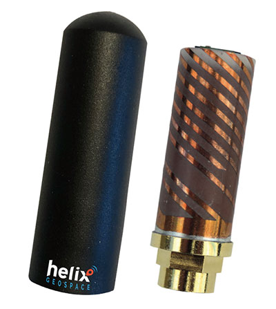
Helix builds precision GNSS antennas that enable product designers to create small, accurate positioning, navigation and timing (PNT) synchronization products that defend against vulnerabilities and threats. Helix is also developing its antennas to provide navigation for autonomous vehicles.
Helix’s patented DielectriX antennas are targeted initially to receive PNT signals from GNSS (GPS, Galileo, GLONASS, Beidou) constellations, and the Satelles STL (Satellite Time and Location) signals delivered over the Iridium constellation as well as Iridium’s voice and data network.
Future antenna variants will support low-Earth orbit (LEO) PNT services being planned and built by private companies, as well as government agencies, the company said.
DielectriX antennas discriminate true satellite signals from multipath signals, interference and jamming, delivering high performance in a compact and rugged form factor. Helix’s customers include defense, automotive, aerospace and critical infrastructure companies.
Helix previously raised £2.5 million from UKI2S and angel investors, and has participated in Wayra UK’s Intelligent Mobility Accelerator programme and Seraphim Capital’s Space Camp Mission 6. Helix also received additional grant funding for advanced antenna development from the European Space Agency, and for anti-jamming/spoofing technology from UKI2S.
Artist’s rendering of GPS IIF satellite. (Image: U.S. Air Force )
Boeing has secured a 10-year, $329.3 million contract to help the U.S. Space Force engineer operational GPS Block IIF satellites, the Department of Defense announced Dec. 20.
The company will perform engineering work to support on-orbit operations of the Block IIF satellites, which were manufactured by Boeing.
Space Systems Command issued the indefinite-delivery/indefinite-quantity contract to address GPS IIF mission requirements across the military and expects work to conclude by Dec. 20, 2031.
The U.S. Air Force deployed the first Boeing-built IIF satellite in May 2010 and launched the 12th and final satellite in February 2016.