Hexagon | NovAtel has updated its GPS Anti-Jam Technology (GAJT) portfolio with the new GAJT-710 product line, which features several enhancements over the previous generation.
The GAJT-710 product line is the next evolution of NovAtel’s battle-proven anti-jam technology for land and marine platforms. The new jammer direction-finding capability of GAJT enables situational awareness and a new silent mode feature reduces its thermal signature. These improvements, including enhanced GNSS tracking performance, are achieved while maintaining the same form and fit of the previous generation product.
GAJT units are deployed worldwide, providing anti-jam protection on land, at sea and in the air. Across these environments, GAJT protects GNSS navigation and precise timing receivers from the growing threats of intentional jamming and unintentional interference. GAJT reliably provides APNT for allied forces no matter the scenario.
“NovAtel has proven itself as a leader for assured PNT through our GAJT portfolio,” said Steve Duncombe, executive vice president of aerospace and defense at Hexagon’s Autonomy & Positioning division. “The new GAJT-710 builds on that success by providing new features combined with existing mission-proven technology to continue providing evolutionary APNT capabilities for the warfighter, national infrastructure and other mission-critical applications.”
NovAtel’s commitment to APNT is central to its product design approach. Deep GNSS expertise and lean manufacturing capabilities enable the delivery of high-performance products like the GAJT-710 in large volumes with minimal production and delivery times, the company said.
The GAJT-710 product line is available for land vehicles, marine vessels, positioning networks and timing infrastructure.
Facebook has open-sourced the design of its time card, which features the ultra-precise u‑blox ZED-F9T timing module, providing easy access to nanosecond-level timing
Photo: u-blox
Facebook has chosen the u‑bloxZED-F9T GNSS receiver module for timekeeping, according to u-blox. By improving the synchronization of networked computers, Facebook’s time card can significantly speed up the performance of its data centers and distributed databases.
By open-sourcing their designs, Facebook has bolstered the adoption of highly accurate timing solutions based on u‑blox technology. These solutions can be adopted by other industries requiring nanosecond-level timing, such as 5G cellular networks or smart power grids.
Facebook set out to create a precise timing solution that reduces the computational overhead required when synchronizing the timing between different computers in a network, u-blox said. The social media company used a u‑blox ZED-F9T multi-band GNSS receiver to sync up its solution with the highly accurate GNSS atomic clocks. To bridge possible gaps in GNSS coverage and keep clock drift to a minimum, the time card contains a backup timing source: a miniaturized atomic clock continuously synchronized with GNSS time.
To maximize the impact of the solution, Facebook decided to open-source the design of its time card, which fits onto a PCIe form factor. Anyone with experience working with microelectronics can turn any PC built on an x86 architecture and featuring a network interface controller into a nanosecond-level-accurate timing and synchronization solution, u-blox said.
Easy access to nanosecond-level timing accuracy — based on the u‑blox RCB-F9T timing board, which hosts the u‑blox ZED-F9T GNSS receiver — opens new avenues in industry segments that rely on highly synchronized signals, such as 5G network base stations that require tighter synchronization than those of previous generations, u-blox said.
As power-distribution networks become more complex to accommodate a growing share of decentralized renewable energy, they are becoming more reliant on reliable and accurate timing solutions. Data centers and computer networks will be able to modernize infrastructure management to speed up performance and reduce latencies.
Facebook has shared the GitHub repository including the specs, the schematics, the mechanics, the bill of material, and the source code in partnership with the Open Compute Project (OCP) under the Time Appliance Project (TAP).
The Automotive News PACEpilot award recognizes post-pilot, pre-commercial innovations in the automotive and future mobility space. These represent product, software/IT system or process and idea incubators that have the potential to revolutionize an automaker’s business.
This was the second year Automotive News recognized PACEpilot honorees and the first time the publication named Innovations to Watch. Swift’s precise positioning platform was selected as one of 10 winners from a group of 23 finalists from 20 companies.
Swift’s precise positioning solution consists of the receiver-agnostic Starling positioning engine and cloud-based corrections from Skylark precise positioning service. The system was designed for autonomy and built to scale for automotive, to change how automakers and OEMs navigate by reducing costs, improving product flexibility, improving safety and delivering high-fidelity, lane-level absolute positioning.
Swift’s technology has been developed into a precise positioning platform that can improve vehicle GNSS-based positioning from an average of 3 meters of accuracy to better than 4 centimeters. Swift’s solution is a software-only implementation with minimal impact to hardware on the vehicle. The accuracy can be guaranteed down to less than one failure per 1,142 years of driving, making it a highly reliable ADAS and automated driving sensor.
“The team at Swift is honored to receive this recognition from Automotive News,” said Joel Gibson, executive vice president of Automotive at Swift Navigation. “Swift is bringing its ground-breaking, high-accuracy localization to the automotive space and we appreciate that those in the industry are taking notice.”
Company responds to calls for stronger national resilience against GNSS vulnerabilities and cyber threats to PNT services
Photo: ADVA
ADVA has responded to calls from the U.S. Department of Homeland Security (DHS) and the National Institute of Standards and Technology (NIST) to protect critical infrastructure from the growing danger of GNSS vulnerabilities and cyber threats to positioning, navigation and timing (PNT) services with the launch of its aPNT+ platform.
The scalable aPNT+ platform meets all the latest guidelines for resilient PNT, the company said. It provides end-to-end control and timing network visibility for robust protection against the catastrophic risks that PNT disruption poses to national security and essential assets such as power grids.
“Cyber threats are at an all-time high. At the same time, the infrastructure that our economies and lives depend on has never been more reliant on weak and highly vulnerable satellite signals. That’s why the U.S .DHS and NIST are driving for PNT services to be more resilient and for network operators to implement strategies to counteract the vulnerabilities of GPS and other GNSS systems, including in-network PTP timing feeds. Our trusted aPNT+ platform is the definitive response,” the company said.
Governments worldwide have issued guidelines to protect businesses and society from disruption to PNT services, including US Executive Order 13905, which was followed by the DHS Resilient PNT Conformance Framework and NIST Cybersecurity Framework for PNT Profile. The government guidelines urge operators to swiftly implement technologies and measures to safeguard vital infrastructure.
Based on these guidelines, ADVA integrated an intelligent and scalable aPNT platform into its product portfolio. Even without GPS or GNSS timing, the solution provides an intelligent, end-to-end self-recovery system designed around a three-fold framework. Integrating sophisticated multi-layer detection, multi-source backup and multi-level fault-tolerant mitigation, it delivers high levels of resilience, robustness and cybersecurity. It integrates the DHS framework’s four levels of PNT resilience while also providing enhanced level-four resilience, the highest level for trusted PNT services assurance.
“For industries and governments, timing is now a critical service in need of urgent protection,” said Gil Biran, general manager, Oscilloquartz, ADVA. “Being open and scalable, it offers an end-to-end range of cost-effective solutions… for augmented resilience, robustness and cybersecurity.”
Technology evaluation capabilities inaugurated in demonstration for U.S. Department of Homeland Seurity
NextNav and Satelles Inc. have partnered on an alternative positioning, navigation and timing (PNT) testbed in the San Francisco Bay area.
Designed and managed by NextNav with a timing source from Satelles, the testbed creates scenarios and conditions to rigorously test the precision and resilience of alternative PNT solutions, allowing technologies to be evaluated in the absence of signals from GPS and other GNSS.
NextNav used the testbed to demonstrate the precision and resilience of the company’s TerraPoiNT network in a GPS-denied environment using STL from Satelles as its absolute timing source. This demonstration for the U.S. Department of Homeland Security (DHS) showcased the timing accuracy and resilience of TerraPoiNT, which delivered timing synchronization better than 50 nanoseconds in urban and semi-urban settings.
As a source of GPS/GNSS-independent time that the U.S. National Institute of Standards and Technology (NIST) determined is highly consistent with Coordinated Universal Time (UTC) — including in deep indoor environments — STL provided the timing signal for the demo instead of GPS.
The advent of the alternative PNT testbed is timely given the recent publication of “Understanding Vulnerabilities of Positioning, Navigation, and Timing” by the Cybersecurity and Infrastructure Security Agency (part of DHS). This important CISA publication urges owners and operators of critical infrastructure to adopt the responsible use of PNT as defined in Executive Order 13905. The new testbed will be used to demonstrate applications for emergency services, telecommunications, financial markets, the electrical grid, and other critical infrastructure sectors.
“Demonstrating the accuracy and resilience of alternative PNT solutions is integral in validating the capabilities of alternative PNT solutions and, ultimately, increasing adoption across use cases and applications,” said Ashu Pande, TerraPoiNT VP at NextNav. “With the development of this testbed, we can emulate real world deployment scenarios and can more effectively instill confidence across the PNT industry in the viability of alternate PNT solutions.”
“The development of this testbed will enable the rigorous, transparent, and replicable testing of alternative PNT solutions,” said Christina Riley, VP of Commercial PNT at Satelles. “We’re excited to be integrated as the GNSS-independent timing reference for this alternative PNT testbed and are looking forward to continuing our collaborative work to build stronger PNT solutions to augment GPS globally.”
The U.S. Department of Transportation categorized TerraPoiNT from NextNav and STL from Satelles as the top-ranked PNT systems in its technology demonstration report released in January. The testbed collaboration between these complementary alternative PNT service providers underscores the companies’ commitment to promoting the adoption of multiple technologies that complement and augment GPS/GNSS to protect the operations of critical infrastructure.
GPS and airborne light detection and ranging (lidar) have revolutionized archaeology. In just a little more than a decade, dozens of previously hidden cities and settlements have been discovered under heavy tree canopy and in other terrain. Many of the sites are in difficult-to-access areas, such as high atop mountains, in vast deserts, or enclosed in thick, nearly impenetrable foliage. Many were only the stuff of legend.
Others are right under our feet. In 2018, early settlements were uncovered in New England, including now-abandoned walls, roads and building foundations.
With the development of lidar, archaeologists gained perhaps their most powerful tool since carbon dating. Lidar began as a million-dollar classified technology. Now lidar units are small enough to attach to unmanned aerial vehicles (UAVs).
Lidar devices send more than 100,000 laser pulses to the ground every second and use their return times to calculate precise elevation data that allow researchers to build three-dimensional maps of a landscape, while GPS receivers provide its coordinates. Lidar fly-overs have revealed ancient cities, temples, causeways, irrigation systems and other structures, which are then ground-truthed by excavation teams.
“Lidar has completely changed the way we survey ancient Maya cities and what we can know about them, and it is a thousand times better than [what we used] before,” Francisco Estrada-Belli told GPS World. Estrada-Belli is a research professor at Tulane University’s Middle American Research Institute.
The application of lidar to archaeology began in 2009, when NASA sponsored a remote-sensing project that showed lidar’s usefulness below the forest canopy. The project revealed the surprisingly vast scope of Caracol, the largest Mayan archaeological site in Belize. Urban Caracol maintained a population of more than 100,000 people with an immense agricultural field system and elaborate city planning.
Since then, lidar has been used the world over to uncover buried secrets from early Roman fortifications in Italy to landscape changes from World War I. Just this August, lidar unearthed sobering evidence of a massacre by Nazi Germany in Poland during World War II.
Image: F. Estada-Belli/Pacunam Lidar InitiativePhoto:
A landmark project in Guatemala illustrates the benefits of lidar. The ancient city of Tikal was one of the best-mapped regions of the Mayan world, but the Pacunam Lidar Initiative quintupled the amount of mapping done in 50 years in a single summer, with 61,000 structures found in an 810-square-mile area invisible to the naked eye because of overgrown vegetation. What experts had mistaken for unusable swampland, for instance, had actually been farmland, crisscrossed with canals. The area may have been home to a population of up to 10 million people. Results were published in Science in 2018.
Seven Solutions sets new record for long-distance White Rabbit high-accuracy time-over-fiber link
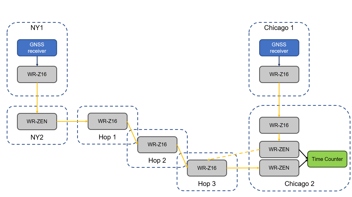
The White Rabbit link has an approximate distance of 1,350 km (840 miles) and was deployed in collaboration with Optiver U.S., a financial company, to connect Chicago and New Jersey trading locations. This link is formed by six long-distance White Rabbit hops using WR-Z16 and WR-ZEN TP devices connected by a combination of DWDM and SyncE-compliant transponders over a public telecommunication fiber network.
Seven Solutions is the leading company in the development and integration of high accuracy sub-nanosecond time transfer and frequency distribution for reliable industrial and scientific applications. Their technology integrates the White Rabbit protocol, the basis for the new high accuracy profile in the IEEE 1588-2019 (PTPv2.1).
This technology has become a reference for different sectors thanks to its unprecedented level of accuracy that outperforms current GNSS-based timing solutions, offering a suitable backup solution to deploy time dissemination networks. In the last few years, the White Rabbit technology has been adopted in the finance sector to deploy plug-and-play local area synchronization and metro-area links connecting different datacenters in financial hubs.
Although the performance of White Rabbit long distance links has been previously validated, this deployment sets a new distance record while integrating new resiliency and interoperability features using the latest WR-Z16 and the WR-ZEN TP devices.
Image: Seven Solutions
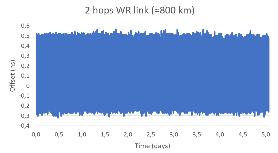
In a series of experiments, the link accuracy and precision were firstly validated setting a three long-distance hops loopback covering an approximate distance of 800 km (500 miles). In this case, the link was measured using an Agilent 53210A time interval counter for a five-day period. This experiment was intended to validate the feasibility of deploying White Rabbit links using commercial SyncE-compliant transponders and commercial telecommunication networks based on DWDM technologies.
Image: Seven Solutions
This measurement confirms the sub-nanosecond precision on a loopback and made it possible to perform network effect calibration to minimize the residual offset caused by the link asymmetry. In this case, a mean offset of 112 ps, a standard deviation equal to 139 ps and a peak-to-peak difference of 880 ps were obtained. Additionally, the offsets followed a gaussian distribution with no daily trends impacted by temperature or humidity.
This result proves the ability of high-accuracy time-over-fiber dissemination to fulfill the most demanding telecom requirements (class D Telecom Boundary Clocks) and corroborates one of the conclusions from the Analyzing a More Resilient National Positioning, Navigation, and Timing Capability report released by the RAND Corporation earlier this year:
“White Rabbit can support time transfer with accuracy that substantially exceeds the needs of almost all users; it is better than GPS. Therefore, this method is a strong candidate for backing up GPS time transfer for users that require atomic clock accuracy and for serving as a ‘national backbone’ for time so that secondary users, such as cellular networks, can perform to the limits of its own subdomain without suffering additional inaccuracies of its own master clock. Less accurate methods, like ordinary PTP, could provide timing to the vast number of other users, like mobile and cellular users.”
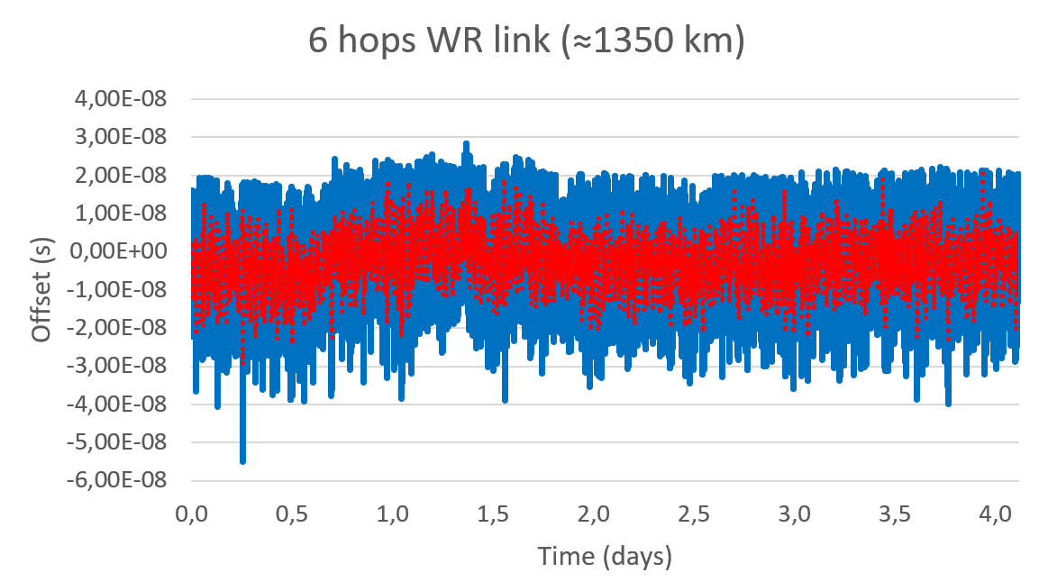
In a second test, the whole link was deployed using GNSS receivers in both ends of the link. The first GNSS receiver was used as the time reference in one end of the link (located in New Jersey) and the second GNSS receiver was used in the second end of the link to compare to the time reference (located in Chicago). Both GNSS receivers are the same model and have a 15 ns RMS jitter specification. In the second location, the local GNSS reference was compared to the remote time reference originating from New Jersey through the long-distance White Rabbit link.
Image: Seven Solutions
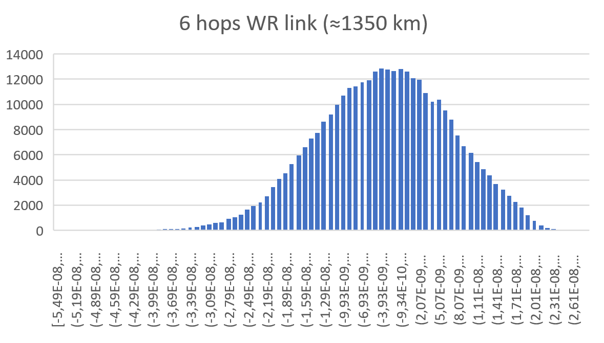
This resulted in a mean offset equal to 2.98 ns, a standard deviation equal to 10.4 ns and a peak-to-peak equal to 83.3 ns. It is noteworthy that due to the time interval counter, some of the samples were filtered. This effect is shown on the histogram but is considered negligible to validate the feasibility of the link.
Image: Seven Solutions
Additionally, the White Rabbit protocol automatically corrects daily effects due to temperature or humidity changes in the link, which are not observed in the measurement even when the GNSS receivers are located more than 1,000 km away from each other. This does not represent the real White Rabbit link error but indicates the limitation of using GNSS receiver to accurately measure the link accuracy.
As can be estimated from the measurements, the previous test and the GNSS specifications, the White Rabbit link maintains an approximately ±1 ns precision. In fact, the results show that the GNSS receivers are outperforming their specifications by almost 50%. The final accuracy is influenced by the GNSS receiver calibration. This link can be calibrated using network effect techniques (as shown in the previous experiment) or using the GNSS receivers themselves.
This experiment complements the results obtained in the U.S. Department of Transportation GPS backup demonstration showing the White Rabbit technology (which was catalogued as the most accurate alternative technology for time distribution) in a real telecommunications network scenario with very long distances. Additionally, it justifies the industrial need to deploy high accuracy time distribution when providing an alternative to GNSS-based timing, as it provides a next generation technology that can benefit other PNT systems and several critical infrastructures that rely on time synchronization for daily operations.
Beyond this, White Rabbit is demonstrated as a disruptive technology that can be used to measure the performance of GNSS in various locations to develop a warning and backup system, to connect high stability time references (for example, atomic clocks) for a suitable long-term ground-based backup to GNSS systems or to connect national metrology institutes around the world to compare different time scales.
This long-distance link represents a new milestone in ultra-accurate time transfer over existing telecom networks that allows cross-validating different linked references or accurately synchronizing them for coordinated actions at tight relative timing.
Furthermore, the deployment through existing telecom network proves its feasibility at affordable cost and opens the door to new disruptive applications. Atomic clocks have evolved to represent very stable references, but it has been typically assumed that time degrades as it is transferred over long distances making accurate comparisons between different references a challenge. This new generation of long-distance links represent a step further into tightly synchronizing different devices over fiber at long distances making them resilient to the vulnerabilities of GNSS timing.
This level of accuracy is key for certain applications and sectors nowadays. Matt Nassr, Data Engineering Lead at Optiver, remarked “Partnering with Seven Solutions has allowed us to better optimize for the highly distributed nature of the financial markets. Being able to establish a nanosecond-level precision link across the Chicago-New Jersey path further improves our ability to provide liquidity across the major US exchanges.”
“This is not a first step on the deployment of long-distance time synchronization networks, this is just one step further,” said Francisco Girela, Americas tech responsible at Seven Solutions. “We have been working for years on improving our devices, easing the monitoring and management, enhancing the resiliency, integrating failover features, adding interoperability with IEEE 1588 (PTP), NTP or PPS and allowing the integration of High Accuracy timing in third party devices thanks to the HATI core. During this journey we have learnt how to integrate the technology to work at its best and we have proved its effectiveness in telecom, data centers, finance, defense, or power grids among others.”
When asked about next steps, Francisco added, “We want to demystify this technology. People think that its deployment is complex or overkill, but that is not true. We see White Rabbit as the core technology to build alternative PNT systems, setting a sub-nanosecond timing foundation that will push the development of a more diverse and more accurate technology ecosystem.
“We have worked to evolve White Rabbit devices to be a market commodity when deploying time synchronization in local areas but providing a level of accuracy that will fulfill the requirements for the current applications and for the next decade. For long distances, complex deployments, or projects we are always happy to assist our customers and partners to get the best from our devices. We are sub-nanosecond natives; we care for every single picosecond.”
Single-base RTK is an excellent choice for many uses but mixing different baseline lengths can yield inconsistent results
By Gavin Schrock, PLS
Gavin Schrock, PLS
The surveying lead for a construction firm started getting calls from his crews — suddenly they were not checking in to existing control with the accuracy required. This presented a conundrum and an immediate resolution was needed to stay on schedule. What had changed? A nearby permanent base, part of the regional real-time GNSS network (RTN), had suddenly gone dark, and when the crews switched to other bases, they got the inconsistent results. Time to call the RTN. (See a primer on RTN.)
I have been operating a regional cooperative RTN for 19 years, and I get these kinds of support calls regularly, but typically only from users of the single-base mountpoints. Most RTN provide, via NTRIP casters, both network RTK (NRTK) solutions — such as master-auxiliary, VRS and FKP — and single-base solutions for each base. The base they had been using was down while the roof of the city building on which it is mounted was undergoing some maintenance.
The construction firm, halfway through a multi-year transportation project, had used the base when they established project control, and for layout and as-built tasks. Using the base, which was slightly more than 4 km from the site, the crews were used to seeing check-in results of 0.3′ (9 mm) or better (horizontal). When they switched to different bases, 23 km and 25 km distant, the results were now inconsistent, and in many instances, double.
This was an easy fix. We met on site and checked results using the network solution; it closely matched the results they were seeing from the original base. Until the original base was restored, this would meet their needs.
It made a lot of sense to use the nearby base, as setting a temporary project base on the congested and sky-view challenged site was impractical. Furthermore, the baseline length of 4 km yields excellent results. Single-base RTK is a powerful tool, and a default for many construction projects, provided that:
the base has an unobstructed view of the sky
the base is free of nearby multi-path hazards
the base receiver and the antenna are of the same or better quality as the rovers
the base receiver and the antenna support the constellations and the signals desired.
In many ways, it is hard to beat single-base RTK. For instance, if you set up a base right on the site, say less than a kilometer away, this should yield the best results possible for RTK, and can be better than network RTK.
However, there are challenges. Single-base, typically “iono-free” solutions common in today’s rovers, degrades over the baseline length. The rule of thumb for many is that the degradation becomes noticeable when baseline lengths exceed 10 km. It is not uncommon for rovers to fix at much longer baseline lengths; 20 km, 30 km, 50 km or more — but results will likely vary from hour to hour or day to day. Changes in ionospheric and tropospheric conditions can bring inconsistencies, particularly over longer baseline lengths.
Network RTK may not beat single-base over very short baselines, but as it uses 5 to 15 bases (depending on the implementation) it can better model in the varied conditions. It can provide great consistency and repeatability, even if an individual base is unavailable, as was the case for this conduction site. There are strengths and weaknesses for both. NRTK brings consistency over a wide area, you do not have to set up (and guard) your own base, and the geodetic values are solved.
If you can have an on-site base, you can under certain conditions see a gain in results. This is especially important for certain applications, such as machine control and precision agriculture, for which tight year-to-year and row-to-row repeatability is key. However, if you may need to use another base at some point, you may be better off starting with NRTK, if it yields the results you seek.
Gavin Schrock is a practicing surveyor, technology writer, editor of xyHt Magazine and operator of a cooperative GNSS network.
First, there was one. In July 1995, the U.S. Air Force declared the Global Positioning System had met all the requirements for full operational capability (FOC). Soon thereafter, there were two. In December of that same year, Russia’s Globalnaya Navigazionnaya Sputnikovaya Sistema (Global Navigation Satellite System, or GLONASS), also achieved FOC. For a quarter century, that was it.
Then, last year, the number doubled, as both the European Union’s Galileo and China’s BeiDou Navigation Satellite System (BDS, named after the Big Dipper asterism, which is known in Chinese as Beidou) achieved FOC.
The Indian Regional Navigation Satellite System (IRNSS, aka Navigation Indian Constellation, or NavIC, which means “sailor” or “navigator” in Hindi) and Japan’s Quasi-Zenith Satellite System (QZSS, also known as Michibiki) are not global yet, but plan to become so. Currently, NavIC is an autonomous regional satellite navigation system, and NavIC-based trackers are compulsory on commercial vehicles in India. QZSS currently complements GPS to improve coverage in East Asia and Oceania, but Japan plans to have an operational constellation of seven satellites for autonomous capability by 2023. The Korea Positioning System (KPS) plans to join the party by 2035.
Who’s next? Will it be another country or a private company? Given that the state-sponsored systems are free to end users, I don’t see what the business model would be for a private GNSS constellation, unless it were to piggyback on one built mainly for another purpose.
Surveyors who have begun to routinely use three or more constellations are over the moon. One, quoted in this month’s cover story, recalls that “the use of GPS for construction staking was an extremely risky proposition” because its residuals exceeded most construction tolerances. Using multiple GNSS constellations, however, has increased confidence in the accuracy of results to the point that some construction companies are relying on GNSS receivers for staking. Additionally, multi-constellation receivers can now increasingly be used under tree canopies and against structures, whether natural or built.
Whatever their mix of military, political and commercial motivations for building, deploying and operating their own GNSS constellations in addition to the original two, the European Union, China, India, Japan, Korea and whichever entity may follow are greatly improving satellite-based positioning, navigation and timing (PNT) for all users everywhere — by increasing accuracy, shortening the time to first fix, and making GNSS more impervious to jamming and spoofing.
In 1978, the year that the U.S. Department of Defense launched the first NAVSTAR GPS satellite (“NAVSTAR” was later dropped from the system’s name), Neil Young sang “Four Strong Winds” (originally written by Ian Tyson and performed by him with his wife Sylvia as the Canadian folk-duo Ian and Sylvia).
Now, GNSS has “four strong winds,” two lighter ones and several more breezes to follow. As a sailor and a navigator, I welcome them heartily. As this magazine’s editor-in-chief, I don’t mind that, like Jeep, Kleenex, Popsicle and Xerox, GPS probably will stick in popular culture as a generic term for global satellite navigation systems way past its accurate description of what is in the box.
Editor’s Note: This video was originally published on November 12, 2019.
Orolia debuted the GSG-8 advanced GNSS/GPS simulator, which is powered by Skydel simulation engine, at ION GNSS+ 2019 in Miami. Watch the video to get an overview of the GSG-8, which the company says was designed to deliver the highest standard of GNSS signal testing and sensor simulation performance in an easy-to-use platform.
Hexagon AB, a global leader in digital reality solutions, has acquired the Jovix software and services business from Atlas RFID Solutions LLC of Birmingham, Alabama.
Jovix is a material tracking software developed specifically for the construction industry, providing project decision-makers with real-time, actionable data regarding material status and location.
The cloud-based and mobile configurable workflow platform offers visibility and traceability into the status and location of materials throughout the engineering, procurement and construction (EPC) lifecycle. This streamlined process, coined “material readiness” by Jovix, ensures construction crews have required materials without delay to complete their work according to plan. This is achieved by fully digitizing the supply chain to provide real-time, geo-contextual, and relational visibility from fabrication to installation.
Jovix combines web-based server software with information from multiple types of sensor tags and readers to automate previously manual, paper-based data-collection workflows about the status and location of material as it moves throughout the construction supply chain.
The software has been deployed in 25 countries on more than 650 job sites, including multibillion-dollar oil and gas and chemical construction projects. There are more than 7,500 Jovix users worldwide.
“The acquisition supports our continued expansion into the procurement, fabrication, and construction market,” said Hexagon President and CEO Ola Rollén. “By removing impediments to productivity that result from material management issues intending to reduce material wait times to zero, Jovix provides value for owner-operators, EPC firms, contractors, fabricators, and suppliers.”
Jovix will be fully consolidated as of Oct. 1, operating within Hexagon’s Project Portfolio Management division. The acquisition has no significant impact on Hexagon’s earnings.
Celestia Technologies Group (CTG) is taking part in the ADACORSA project, a European initiative designed to unlock the potential of long-range and beyond-visual-line-of-sight (BVLOS) drones and give Europe a world-class drone industry.
ADACORSA — Airborne Data Collection on Resilient System Architecture — is a major collaborative project launched in May 2020 that aims to demonstrate the safety and efficiency of drones or unmanned aerial vehicles (UAVs) in extended out-of-line-of-sight operation ranges.
Specifically, it draws on European expertise in developing sensor and communication technologies for UAVs to underpin their role and reliable capability in long-range applications, including observation, analysis and transport, taking them one step further toward being integrated into conventional airspace.
ADASCORA also seeks to increase public and regulatory acceptance of modern UAV or drone technology. More than 49 specialist companies from 12 European countries are expected to contribute know-how and practical support. The project also aims to research and develop innovative components and systems for airborne observation and detection, telecommunication and data processing along the electronics value-chain.
Task Forces Established
To meet ADACORSA’s ambitious targets, task forces have been set up, one of which will be led by CTG. The company will lead the development of electronic components for reliable and fail-operational environment perception and run one project demonstrator designed to integrate unmanned aircraft systems safely into the common European airspace and ensure that they operate correctly in a multi-unmanned aircraft system environment.
CTG is a Dutch supplier and part of a pan-European company group providing innovative technology products, systems and services to space, aerospace, defense, telecommunications and scientific markets.
Galileo + EGNOS Transponder
CTG will use its expertise in on-board UAV electronics to develop a lightweight, high-performance transponder capable of sending and receiving accurate identification and location data for unmanned aerial vehicles.
Positioning will be based on Galileo, supplemented by its European Geostationary Navigation Overlay Service (EGNOS), allowing all airspace users to know the location of the vehicle and contribute to safety while supporting other on-board systems such as detect-and-avoid equipment.
The transponder will be based on conventional aviation technologies such as Mode S Interrogator and Automatic Dependent Surveillance-Broadcast (ADS-B) and will integrate new concepts including network identification, meaning the vehicle can fly safely in various scenarios. These include in locations close to airports, in drone fleet operations and within the U-Space environment. U-space is a set of European services and procedures designed to support safe, efficient and secure access to airspace for drones.
ADACORSA has received funding from the ECSEL Joint Undertaking (JU) under grant agreement No. 876019. The JU receives support from the European Union’s Horizon 2020 research and innovation program and Germany, Netherlands, Austria, Romania, France, Sweden, Cyprus, Greece, Lithuania, Portugal, Italy, Finland and Turkey.