Blog

  • NASA preps Mars helicopter as war shapes defense tech future

    NASA preps Mars helicopter as war shapes defense tech future

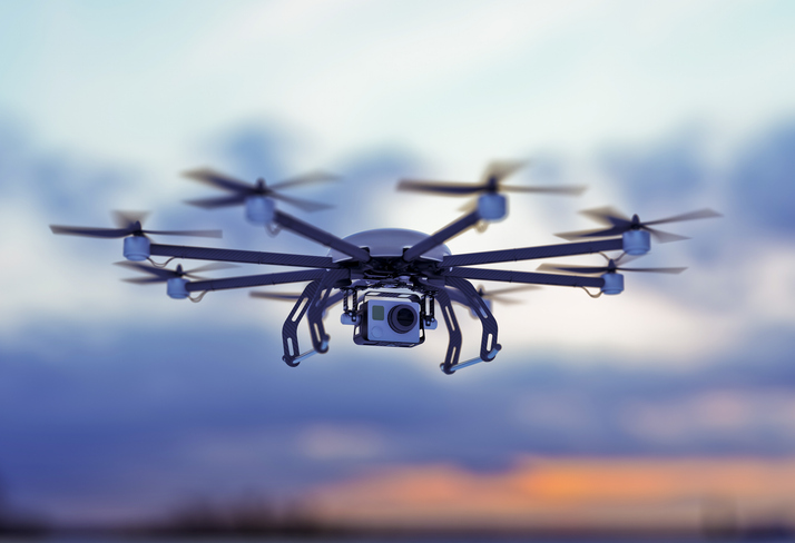
    It’s always good news when we hear about NASA’s “out-of-this-world” next steps toward building a replacement for Ingenuity, the small Mars helicopter-drone. With 72 flights over 1,004 days, Ingenuity outlived NASA’s expectation of just 30 operational days on Mars. It ended up serving as a trailblazer for the SUV-sized Perseverance rover as it worked its way around Jezero Crater. Built with a large number of smartphone components, it’s actually amazing that this thing survived for so long, given the radiation environment on the surface of Mars, along with the harsh temperature extremes of daytime 32°F to nighttime minus 130°F. How a Samsung S5 phone battery survived, operating so far outside its design temperature range, is hard to fathom.

    NASA’s 20-year plan for future Mars exploration now looks to take advantage of the huge expansion of the envelope for exploration that the small 30-day Mars helicopter brought to the Perseverance mission: “Enhanced mobility systems will enable exploration of challenging terrains and increased operational range. Aerial mobility technologies will facilitate access to previously unreachable areas on Mars.”

    NASA drone flies over ‘Mars Hill’ in Death Valley during recent navigation tests (Photo: NASA/JPL)
    NASA drone flies over Mars Hill in Death Valley during recent navigation tests. (Photo: NASA/JPL)

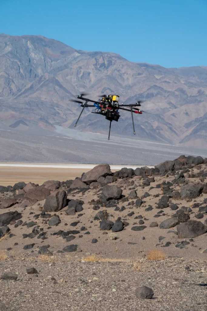
    So now NASA is working on the next Mars rover mission and on improvements for its accompanying airborne support. A team recently took three commercial drones into Death Valley to work on overcoming navigation problems that Ingenuity encountered on Mars flying over “bland” terrain with few visual features for its optical navigation system. Sand dunes without features on Mars messed with Ingenuity’s navigation solution, including on its 72nd flight.

    Death Valley and Mesquite Flats Sand Dunes were two places the NASA team visited to test improved navigation algorithms installed on existing commercial drones, and they found some improvements by adding camera filters. The new software helped find landing spots in cluttered terrain.

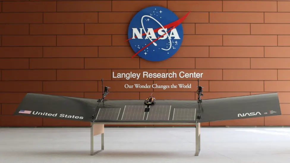
    But now new initiatives are seeking ways to get crewed flights to Mars in the next couple of years, well ahead of NASA’s timetable, which doesn’t move to anything crewed until around 2030. NASA still seems to prefer to pursue landers to gather much more data on Mars before risking crewed flights. Robotic dogs are also being investigated that can traverse rugged uphill areas that landers cannot access, as well as a winged glider the size of a small school bus.


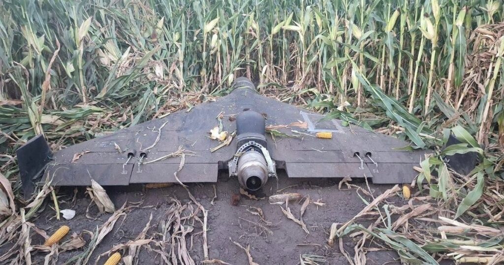
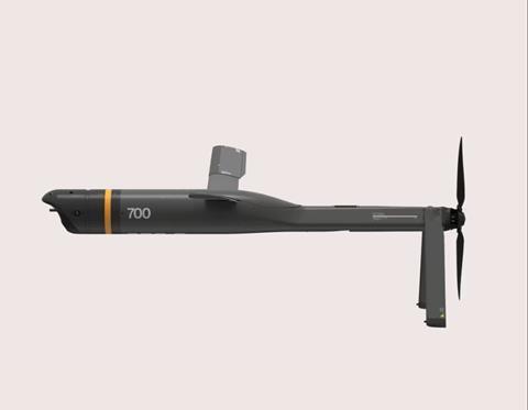
    Meanwhile, the never-ending Russia-Ukraine war rages on, dominated by drone attacks from both sides. Russia is increasingly using Iranian Shahed or the equivalent Russian-produced Geran-2 one-way drones, while Ukraine intercepts them with low-end modified commercial drones. This stalemate has $20,000 Geran-2 drones being brought down by high-speed interceptor drones built for $2,000 to $6,000 — in other words, the cost of attrition might determine the victor.

    Russian Geran-3 jet-powered drone downed by Ukraine. (Photo: DIU)
    Russian Geran-3 jet-powered drone downed by Ukraine. (Photo: DIU)

    However, Russia has now introduced a jet-powered Geran-3 model that flies at up to 230 mph, which Ukraine has apparently been able to bring down.

    As we well know, Ukraine not only regularly receives Western military equipment but also civilian drones in large numbers. But an industrial capability has also been created in Ukraine to design, develop and build high volumes of drones. So it’s not surprising that Ukraine has revealed its own interceptor drone known as Sting.

    STING interceptor drone and imagery striking a Shahed drone. (Photo: Wild Hornets Group)
    STING interceptor drone and imagery striking a Shahed drone. (Photo: Wild Hornets Group)

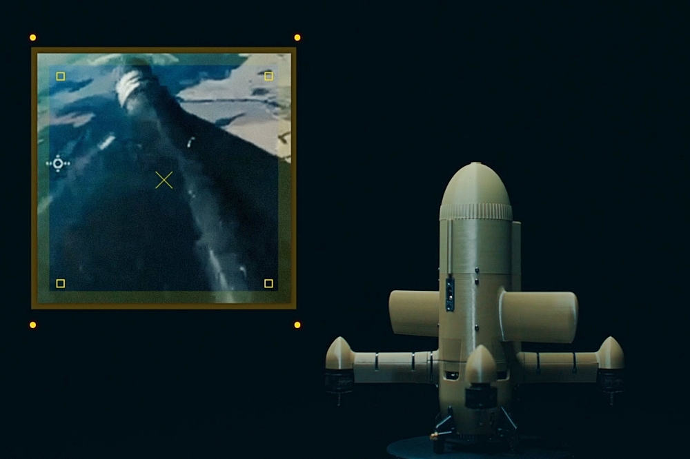
    Nevertheless, Sting has four rotor props and should be no match for a Geran-3 flying at top speed, even though Sting is claimed to be capable of 215 mph. The Russian jet-powered drone also apparently comes with anti-jam capabilities and a satellite navigation system, but Russia has yet to field these new drones in large numbers. Of course, Ukraine says it has already developed jet-powered interceptor drones — so the step up to the next level of technology should happen for both sides, but of course, costs increase for both sides, which neither can really afford.


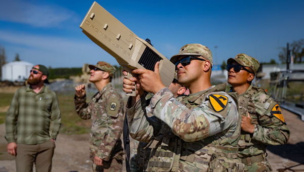
    Defense has always affected the speed of development for any technology — government funding and oversight are major incentives for new companies to emerge and for new technologies to be developed. Anduril Industries has recently emerged as a new entrant to the U.S. industrial defense complex, specializing in autonomous systems. Anduril’s products include unmanned aircraft systems and counter-UAS, and they have made big strides in both areas.

    Anduril is a relatively new company, initially founded in 2017, so its products are fresh off the drawing board and its product improvement experience is at best eight years. The big U.S. defense contractors have fielded and corrected decades of problems in their high-tech systems, so new generations come with hard-learned design and build understanding. The advantage for Anduril is that they are not bound by the restrictions of a long-established industrial heritage, but this can also mean they may still have a way to go in learned experience.

    Nevertheless, in high technology, much is new technology and new software and new approaches to build. So it takes effort to not only make this stuff work but also to make it work reliably.

    Altius — 33lb warhead attack drone. (Photo: Anduril)
    Altius — 33lb warhead attack drone. (Photo: Anduril)

    Anduril builds lots of test articles and rapidly evolves the design through rigorous internal and real-world testing. So it’s not uncommon to see test failures — this is how improvements are developed.

    Recent U.S. defense tests that saw crashes at Eglin Air Force Base in Florida drew a lot of bad press, given that the Altius drone had already been battle-tested in Ukraine. However, if the approach of lower cost, high volume and attritable drones is the one we have chosen, it may take a little more time to get maturity into the beast.


    Navigation testing for NASA’s next Mars drone, jet-powered attack drones, and evolving interceptor defenses and drones from a new player on the U.S. defense scene — a pretty wide range of unmanned aircraft applications.

  • Safran Federal Systems selected by Moog for Hercules Avionics Suite

    Safran Federal Systems selected by Moog for Hercules Avionics Suite


    Safran Federal Systems, a provider of assured position, navigation and timing (APNT) solutions, has been selected by Moog Inc. to provide its Skynaute navigation solution as part of Moog’s Genesys Avionics Suite for the Lockheed Hercules platform (L-Series and C-130).

    Skynaute is a hybrid inertial/GNSS navigation system based on HRG Crystal technology. It will serve as a critical component of the Hercules avionics suite designed and integrated by Moog.

    The Skynaute navigation unit by Safran. (Photo: Safran Federal Systems)
    The Skynaute navigation unit by Safran. (Photo: Safran Federal Systems)

    Under this agreement, Safran Federal Systems will supply Skynaute units to support enhanced navigation performance in demanding operational environments.

    “Being selected by Moog underscores the reliability, innovation, and mission readiness of our Skynaute solution,” said Tony Full, senior director of Business Development, Navigation Systems, Safran Federal Systems. “This collaboration continues our tradition of delivering precise, resilient navigation technologies to meet the evolving needs of military aviation.”

    Skynaute is engineered to meet the needs of both legacy and next-generation military aircraft, providing superior accuracy and robustness with minimal size, weight, and power consumption. The system is suited for retrofit and modernization programs, particularly for platforms like the Hercules that remain integral to global air mobility and tactical transport operations.

    Safran Federal Systems supports Safran Defense & Space Inc. (Safran DSI) by providing APNT technologies across a range of defense and aerospace applications.

  • Robosat partners seek improved localization of autonomous machines

    Robosat partners seek improved localization of autonomous machines

    Researchers from Finland, Switzerland, Spain and Romania gathered at Tampere University in Finland for a workshop this month within the Robosat project focusing on localization of autonomous machines.

    Workshop participants discussed and demonstrated novel technical solutions to improve localization, particularly of autonomous machines operating in challenging and unconstrained environments, such as forests and mountainous regions.

    The Robosat project aims to change how autonomous robots navigate in the wild by integrating multi-sensor and multi-GIS data. During the Tampere workshop, partners from Tampere University (Finland), ETH Zürich (Switzerland), Universitat de València (Spain) and CITST (Romania) discussed strategies for sharing data, identifying relevant GIS and GNSS datasets, and leveraging AI for autonomous labeling of large-scale data. 

    Key topics included the integration of multi-sensor and multi-GIS data to enhance positioning accuracy, planning piloting tests with ETH’s ANYmal robot and TAU’s new I/Q GNSS grabber device, and discussing methods for AI-driven data labeling for massive datasets collected during field trials.

    The Tampere University project team includes Elena Simona Lohan and Jari Nurmi as supervisors and Ph.D. students Yelyzaveta Pervysheva and Muhammad Safi.   

    The Robosat efforts supports applications in robotics, environmental monitoring, and industrial automation. By combining expertise across Europe, Robosat intends to pave the way for smarter, safer and more efficient autonomous systems.

    It also aims to provide new open-access rich datasets to the research community. A first dataset enabling multimodal classification studies has already been published on Zenodo as a collaborative work between Tampere University and CITST teams.

    The Robosat project

    Autonomous robot navigation in the wild using satellite-based 3D geographical information (ROBOSAT) aims to provide a scalable MultiGIS high-quality data collection platform through the use of a quadrupedal robot that can autonomously perform long-distance missions in challenging environments, such as Alpes mountains or Finnish forests.

    Consortium organizations are comprised of three universities and one SME:

    • Tampere University, Finland. Expertise: GNSS, wireless positioning, sensing, and communications, RF Fingerprinting and interference mitigation. Coordinator: Elena Simona Lohan
    • ETH, Switzerland. Expertise: automation, mapping, control theory, and legged-robot research. PI: Marco Hutter
    • Universitat de Valencia, Spain. Expertise: computer science, database management, machine learning. PI: Joaquin Torres Sospedra
    • CITST, Romania. Expertise: machine learning/artificial intelligence, robotics, exploitation. PI: Irina Mocanu.
  • IATA sounds alarm over rising GNSS interference

    IATA sounds alarm over rising GNSS interference

    Collated from various news reports

    The International Air Transport Association (IATA) has called for vigilance following the increasing number of GNSS spoofing and jamming incidents worldwide. The growing interference poses a significant risk to flight navigation and pilot safety.

    Of note is a spike in incidents at major Indian airports. Almost 2,000 GNSS interference incidents have been logged at airports in India since 2023, including the airports in Delhi, Mumbai, Kolkata, Amritsar, Hyderabad, Bengaluru and Chennai.

    IATA represents more than 360 airlines, accounting for 80% of global air traffic. Indian carriers Air India, IndiGo, Air India Express and SpiceJet are members.

    “GPS spoofing and jamming incidents are increasing rapidly across the world,” said IATA Director General Willie Walsh, speaking at an industry event in Geneva. “This is not merely a technical concern — it’s an operational vigilance issue for pilots.”

    Walsh noted a higher frequency of interference events, expanding well beyond conflict zones and affecting global civil aviation routes.

    India’s Civil Aviation Ministry informed Parliament that between November 2023 and November 2025, a total of 1,951 GNSS interference cases were reported. The data collection began after the Directorate General of Civil Aviation (DGCA) issued an advisory circular in November 2023, mandating airlines to report all GNSS-related disruptions.

  • UK identifies issues in addressing PNT resilience

    UK identifies issues in addressing PNT resilience

    The United Kingdom has issued a summary of input it requested on positioning, navigation and timing (PNT) technologies. The UK deems PNT resilience critical for the UK’s economy.

    The 2023 Government Policy Framework for Greater PNT Resilience included an action to “develop a PNT growth policy, including R&D programmes, standards and testing, to drive innovation for PNT based productivity.”

    After a call for evidence, the UK Department for Science, Innovation & Technology received 128 responses from business, industry, academics and the public. These views on opportunities and challenges for the UK’s PNT industry are gathered in a document available online.

    Key themes identified

    • A viable market exists for GNSS-independent PNT, with respondents citing applications in defense and critical infrastructure.
    • Awareness of GNSS vulnerabilities in end users and critical infrastructure sectors is low.
    • Potential opportunities in GNSS-independent PNT and other technologies include eLoran, LEO-PNT, 5G, quantum PNT, inertial systems, and applications for GNSS-denied environments.
    • Short-term challenges include funding constraints and a lack of legislation and standards.
    • Long-term challenges include scalability, lack of sovereign manufacturing capability, and insufficient planning .
    • The industry is experiencing a skills shortage, especially in engineering, with a limited talent pipeline and lack of dedicated training opportunities.

    In all, 128 responses were received from businesses (sellers and users of PNT), academics, industry bodies and the public. Respondents could select multiple sectors when describing their background; the defense sector was selected most frequently (39 responses), followed by space (35 responses), aviation and drones (28 responses), maritime (28 responses) and communications (27 responses).

    Responses will be used, along with wider research, to inform future government policy interventions to support the UK PNT sector.

  • US Army seeks sources for GNSS-denied optical tracking

    US Army seeks sources for GNSS-denied optical tracking

    The U.S. Army is starting market research for possible sources of an optical tracking solution for its test ranges to use in GNSS-denied environments.

    The Army Contracting Command – Orlando issued a Sources Sought Notice Dec. 11 on behalf of the Test Resource Management Center Test and Evaluation/Science and Technology (T&E/S&T) Program.

    The Army wants to identify potential sources in the market having the interest, skills and ability to complete a thorough technology study and trade space analysis related to the viability of Time-Space-Position Optical Tracking (T-SPOT) for use on test ranges. The technology would be used as a time-space-position information (TSPI) truth sensor in GNSS-denied environments.

    Required capabilities

    The primary objective of a T-SPOT prototype effort would be to develop the system architecture, concept of operations, and comprehensive trade space analysis based on the results of modeling and simulation of the future-state system. The intent of the effort would not be to deliver the fieldable system itself but rather to answer whether/how such a system would achieve its performance goals.

    A future T-SPOT system should

    • achieve 3D TSPI accuracy comparable to the accuracy of real-time kinematic positioning (RTK) GNSS navigation systems.
    • be generated in a near-continuous manner, notionally at an update rate comparable to GNSS navigation systems.
    • achieve full performance during daylight and in good visibility conditions, with the goal of operating at day and at night and in all-weather conditions.
    • support temporary and modular integration with airborne systems being tested, operating at altitudes typical for the operation of U.S. Air Force cargo and single-engine training aircraft, with the goal of supporting aircraft closer to or on the ground. 
    • minimize its size, weight and power (SWaP) budget for integration with crewed aircraft, with the goal of supporting integration with small uncrewed aerial systems.

    In addition to the sensor hardware hosted on the SUT, a future T-SPOT system should rely on terrestrial features solely comprised of passive landmarks (no active emissions; no required power). The system may employ synthetic landmarks (e.g., purposely installed fiducials) and/or pre-existing landmarks (of either natural or human origin).  While the system must operate independently of GNSS, GNSS may be used pre- and post-test (i.e., for landmark surveying).

    More details are on the announcement page. The deadline for responses is Jan. 30.

  • EUROCAE seeks input on use of GNSS in UAS

    EUROCAE seeks input on use of GNSS in UAS

    The draft EUROCAE document ED-348: Guidelines for the use of multi-GNSS solutions for UAS – Medium Risk is now open for comments.

    Between 2019 and 2022, EUROCAE group SG-6 developed guidelines for low risk operations Sail I and Sail II (ED-301) to support the use of GNSS and show compliance with previously established safety objectives (SORA OSO#13).

    SORA OSO#13 is also applicable to higher SAIL operations with a different level of assurance, which may take the form of a service level agreement (SLA) with external GNSS service providers. This changes the approach with respect to low-risk operations, so a new standard will be defined instead of evolving ED-301.

    “When discussing the use of GNSS in UAS operations, the assessment cannot be limited to GNSS as an external service only, but should consider other critical aspects such as system architecture, vulnerabilities, performance analysis, receiver design or integration, among other elements,” SG-6 posted on the EUROCAE website.

    Because the requirements for medium-risk operations are more demanding than for low-risk operations, the scope of the ED-348 document not only covers compliance with OSO#13 requirements — where GNSS is considered an external service to support UAS operations — but also considers other relevant SORA OSOs where GNSS plays a relevant role.

    Based on this information, the guidelines cover the following OSOs in regard to GNSS support SAIL III operations:

    • OSO#05: UAS is designed considering system safety and reliability.
    • OSO#08: Operational procedures are defined, validated and adhered to.
    • OSO#13: External services supporting UAS operations are adequate to the operation.
    • OSO#23: Environmental conditions for safe operations are defined, measurable and adhered to.
    • OSO#24: UAS is designed and qualified to operate under adverse environmental conditions.

    Interested parties are invited to review the proposed draft on the EUROCAE Workspace and complete the comment form. Non-members of EUROCAE can register and click on “Access only to Open Consultation”). Early replies are encouraged; the deadline for comments is Feb. 2, 2026.

    The non-profit European Organisation for Civil Aviation Equipment (EUROCAE) is based in Lucerne, Switzerland, and serves as a European forum focusing on electronic equipment for air transport.

  • SatLab launches SL8 laser RTK receiver

    SatLab launches SL8 laser RTK receiver

    SatLab Geosolutions has launched a new GNSS receiver, the SL8. The SatLab SL8 Laser RTK combines dual cameras, GNSS, an inertial measurement unit (IMU) and visible laser technology to make surveying faster and easier.

    With non-contact measurement, image-assisted targeting, CAD live-view stakeout, and a built-in LoRa radio. It ensures smooth, reliable work even in complex or GNSS-limited environments, SatLab said.

    Photo: SatLab
    Photo: SatLab

    The SL8 achieves 2 cm accuracy within 10 meters and enables efficient data collection across bridges, tunnels, riverbanks, and other sites where traditional GNSS methods are restricted.

    It features image-assisted targeting through SatSurv software, displaying laser points directly on real-time images for quick and precise aiming. Its automotive-grade IMU requires no manual calibration or initialization and enhances measurement accuracy by up to 40% in GNSS-challenged areas.

    A built-in multi-protocol LoRa transceiver provides stable transmission beyond 15 km and compatibility with multiple RTK brands. The integrated CAD and visual stakeout functions combine live imagery with CAD data, allowing users to visualize target points on site and increase layout efficiency by up to 50%.

    Download a brochure.

  • U-blox launches SIG 2.00 GNSS firmware

    U-blox launches SIG 2.00 GNSS firmware

    Dedicated firmware delivers AFC-compliant geolocation and adheres to 6 GHz spectrum rules, accelerating deployment of location-enabled Wi-Fi infrastructure.

    U-blox has released Standard Infrastructure GNSS (SIG) 2.00, a dedicated GNSS firmware solution for Wi-Fi 6E/7/8 access points operating in the 6 GHz band.

    Designed to meet Automated Frequency Coordination (AFC) requirements in the U.S. and Canada, SIG 2.00 enables access points to determine their geolocation with 95% confidence-bound accuracy. It also delivers improved positioning accuracy under multipath environments, ensuring AFC systems receive reliable geolocation data.

    Compatible with the u-blox M10 and F10 platforms, the firmware simplifies compliance processes and speeds up integration, helping OEMs deploy high-performance, location-enabled Wi-Fi networks quickly and at scale.

    Turnkey geolocation for regulatory-ready 6 GHz deployments

    As Wi-Fi infrastructure expands into the 6 GHz band, compliance with regional spectrum regulations becomes essential for Standard Power operation. SIG 2.00 offers a ready-to-integrate GNSS solution that meets these requirements out-of-the-box, reducing design effort while ensuring operational reliability.

    Its precise location reporting enables Wi-Fi 6E/7/8 access points to coexist safely with incumbent users of the 6 GHz band, such as microwave and satellite services.

    Flexible design options on M10 and F10 platforms

    SIG 2.00 runs on two established u-blox GNSS platforms. On u-blox M10, it offers a cost-efficient single-band (L1) ultra-low-power solution for mainstream deployments. On u-blox F10, it provides a dual-band (L1/L5) GNSS with RAW data output, delivering enhanced robustness in multipath or dense environments.

    This flexibility allows OEMs to meet a wide range of performance and integration requirements while achieving 95% confidence-bound accuracy and maintaining regulatory compliance.

    By removing complexity from AFC compliance, SIG 2.00 supports rapid design-in for enterprise and industrial Wi-Fi deployments, from campuses and stadiums to city-wide infrastructure. With robust positioning accuracy and streamlined integration, it helps accelerate the adoption of high-performance, location-enabled wireless networks in the 6 GHz band.

  • NextNav to begin operating 5G-powered PNT network

    NextNav to begin operating 5G-powered PNT network

    The 5G PNT network in Santa Clara County will mark the first real-world demonstration of a 5G-powered backup to GPS

    NextNav Inc., a leader in next-generation terrestrial positioning, navigation, and timing (PNT) and 3D geolocation solutions, will commence operations of a 5G PNT network in Santa Clara County, California, as early as Dec. 11.

    Network operations of positioning, navigation and timing applications represent the next milestone toward commercial readiness and the mission to deliver a resilient complement to GPS.

    The 5G PNT network will consist of multiple fixed base station locations using a standards-compliant 5G signal with a positioning reference signal (PRS) enabled, a standalone 5G core, and NextNav’s 3D PNT architecture. The network’s authorized technical parameters will align with those in NextNav’s proposal to optimize the lower 900 MHz band to enable a terrestrial, widescale backup to GPS that is broadly available to critical infrastructure, public safety and American consumers.

    “We’re incredibly pleased to continue demonstrating our technology in a real-world operational environment,” said Mariam Sorond, CEO of NextNav. “Activating this network is a critical step in our commercialization process, proving that robust 5G broadband service and high-integrity PNT can be delivered together, at scale, using standard 5G equipment.”

    The 5G PNT network will validate NextNav’s 5G PRS-based PNT end-to-end architecture under real-world conditions.

    “This is the first public demonstration of a full-scale and operational 5G-based PNT in live deployment, delivering both resilient PNT and broadband service simultaneously,” said Arun Raghupathy, NextNav Co-Founder and CTO. “Through this commercialization deployment, we’re validating our 5G-based network can deliver accurate 3D location, improved timing synchronization, and enhanced resilience. This real-world deployment is critical to establishing U.S. leadership in next-generation PNT technologies.”

    The 5G PNT network will support the broader adoption of 5G-based terrestrial PNT with 5G broadband capabilities for operators, enterprises and ecosystem partners. This deployment will also prove that NextNav’s software solution is ready to scale and deliver commercial PNT while serving the critical national security and public safety needs of the United States.

  • AeroVironment expands Puma visual navigation system kit to Puma LE

    AeroVironment expands Puma visual navigation system kit to Puma LE

    AeroVironment has integrated its visual navigation system (VNS) kit with the Puma Long Endurance (LE) small unmanned aircraft system, delivering GNSS-denied navigation capability to ensure mission success.

    First introduced in 2022 for the Puma 2 AE and Puma 3 AE, the VNS kit uses advanced computer vision and onboard processing to deliver precise, GNSS-independent navigation. Its integration into Puma LE now extends this capability across the full Puma family for greater flexibility and resilience in degraded or denied environments.

    “Assured navigation is critical to the mission, especially as GNSS becomes an increasingly vulnerable resource,” said Jason Hendrix, Vice President of Small Uncrewed Systems for AV. “By fusing visual and inertial data in real time, the system enables uninterrupted flight paths, accurate geolocation, and mission continuity in unreliable GNSS regions.”

    Using a suite of downward-facing sensors, cameras and onboard computing, the VNS kit performs visual inertial odometry (VIO) to capture and analyze terrain imagery, estimating true aircraft position in real time. The system fuses continuous visual data from the cameras with motion inputs from onboard inertial sensors to calculate precise position, velocity, and orientation — allowing the aircraft to know where it is and where it is going when GNSS is not available. It automatically transitions between GNSS-enabled and GNSS-denied modes with zero pilot input, ensuring uninterrupted mission continuity in contested environments.

    In September, AV announced several upgrades to the Puma LE platform that include the integration of a Laser Target Designator and the release of the Universal Gimbal Kit, enhancements that evolve Puma LE beyond ISR into a cutting-edge precision-engagement system.

    “Every upgrade to Puma LE, including the addition of the VNS kit and our new laser designator and gimbal capabilities, is driven by one goal: giving the warfighter greater confidence, flexibility, and capability,” said Trace Stevenson, president of Autonomous Systems at AV. “These recent releases are a great example of AV constantly evolving our platforms to ensure they are at the forefront of technology and providing best in class capability to the warfighter.”

    The VNS Kit is designed as an add-on option for new Puma 3 AE or Puma LE system orders and as a retrofit kit allowing existing Puma 2 AE, Puma 3 AE, and Puma LE customers to upgrade fielded systems. The compact two-piece add-on installs into existing Pumas with minimal impact on performance and fits within the standard Puma cases for efficient mission packout. The standard Puma LE system weighs 23.8 pounds and offers 6.5 hours of endurance, a 60-kilometer range, is inaudible at 500 feet and features tool-free payload swaps for seamless transitions between intelligence, surveillance and reconnaissance (ISR), targeting, and other mission sets.

  • Moldova’s positioning system now uses Galileo

    Moldova’s positioning system now uses Galileo

    The MOLDPOS National Positioning System in Moldova has been integrated into the European Position Determination System (EUPOS),  a pan-European GNSS augmentation service.

    The MOLDPOS navigational system uses both GPS and GLONASS, and now Galileo has been added, according to Anatol Ghilas, director of the Agency of Land Relations and Cadastre (ALRC) of Moldova. Ghilas said the question of integration with the European system of Galileo was often discussed, and is a step forward in promoting the positioning technology.

    Creation of MOLDPOS was gradual. First, sites for placement of MOLDPOS stations were selected, then the stations were installed. Once installations were in place, the system was tested and launched. Now it is integrated into EUPOS.

    Moldova had been a member of the European Position Determination System since 2008.

    According to Norwegian Ambassador to Moldova Øystein Hovdkinn, Moldova and Norway are situated in opposite parts of Europe, but it did not impede establishing friendly relations. Norway provided financial aid to build MOLDPOS.

    Hovdkinn said that the Government of Norway supports the program of reforms in Moldova. The project’s goal is to promote Moldova’s development as a modern country and to promote its integration in Europe.

    According to Gheorghe Duca, president of the Moldovan Academy of Sciences, implementation of MOLDPOS will have a positive influence upon the country’s social, economic and scientific sectors.

    “A digital map is necessary for preventing floods, for rehabilitating roads, in agriculture and in science,” Duca said, adding that Moldova is the first country on the border with the European Union that will have digital maps, expected to be available in 10 months.