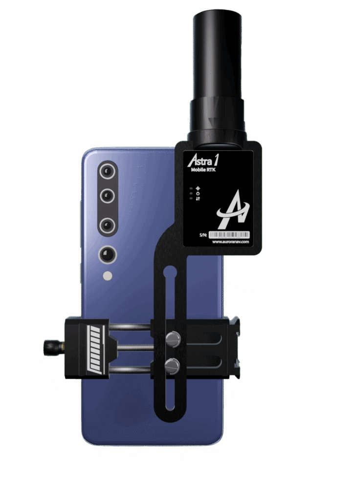
The small, light RTK receiver integrates the Anypos App and LoRa radio for high-precision surveying, photo surveys and 3D modeling.
Image: Aurora Navigation
Aurora Navigation has launched the Astra1 Mobile Visual RTK, a professional-grade GNSS receiver engineered to redefine high-precision mobile data acquisition.
The Astra1 is an ultra-compact (60g) solution designed to deliver reliable, centimeter-level positioning and advanced 3D mapping capabilities through seamless integration with a smartphone and the proprietary Anypos App.
The Astra1 Mobile Visual RTK is built to meet the demand for highly portable, yet exceptionally reliable, high-precision tools that simplify complex field operations.
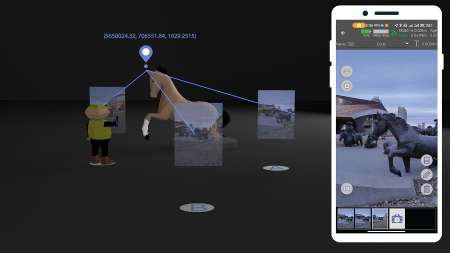
Full Field Functionality. Users can perform standard surveying tasks, stakeout and RAW data capture directly from their mobile device.
Photo Survey. The system enables high-accuracy measurement of inaccessible or remote points, providing typical accuracy under 4 cm and significantly enhancing operator safety and efficiency.
Georeferenced 3D Scanning. Astra1 allows users to capture photos with precise RTK coordinates, enabling the creation of accurate 3D models for detailed construction verification and digital twinning applications.
Key Functional Features and Reliability:
Unmatched 60 grams and matchbox size
1408 channels, multiple frequencies
900MHz LoRa radio, compatible with Aurora Nav G1000 geodetic receiver
Accuracy: RTK 8mm+1PPM Horizontally, 15mm+1PPM Vertically, Photo survey <4 cm (2-15 m distance)
AI-enhanced reliability
IP67-rated
Mobile Visual Survey Workflow via the Anypos App, transforming a standard smartphone into a comprehensive high-precision data collector.
Image: Aurora Navigation
Industry applications and vision
Astra1 is a suitable and useful tool for professionals across multiple sectors:
Surveying & Engineering. Streamlines field stakeout and topographic data collection with minimal equipment.
UAV & Robotics. Serves as a lightweight PNT solution for GCP collection or base station for unmanned aerial vehicles (UAVs) and robotic platforms.
BIM/Digital Twin. Provides the foundational high-accuracy data required for complex 3D modeling projects.
“We designed Astra1 to address the fundamental need for portability, safety, speed, reliability and simplicity in professional geospatial data collection,” said Zhitao Lyu, founder and CEO, Aurora Navigation. “By focusing on superior performance in tough environments and integrating our Anypos App for a seamless visual workflow, we are delivering a tool that significantly boosts efficiency and safety, and provides survey-grade confidence to every user.”
Headquartered in Calgary, Canada, Aurora Navigation is focused on developing and delivering innovative GNSS solutions. The company is committed to advancing the efficiency and reliability of geospatial data collection through its unique blend of compact hardware design and advanced positioning algorithms.
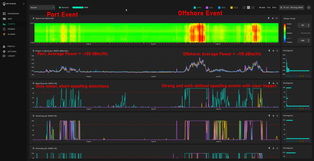
Shipborne Measurements Near the Kaliningrad Border
A major new report by GPSPATRON gathered data between June 23 and Oct. 14, aboard a vessel routinely leaving the Port of Gdańsk and performing extended maneuvers in open water.
The vessel conducted multiple offshore measurement campaigns, resulting in a shipborne dataset that provides a far more accurate representation of the true GNSS environment experienced by maritime operators in the Gulf of Gdańsk. It also reveals a level of interference complexity and intensity not visible in a previous coastal study.
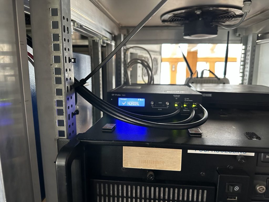
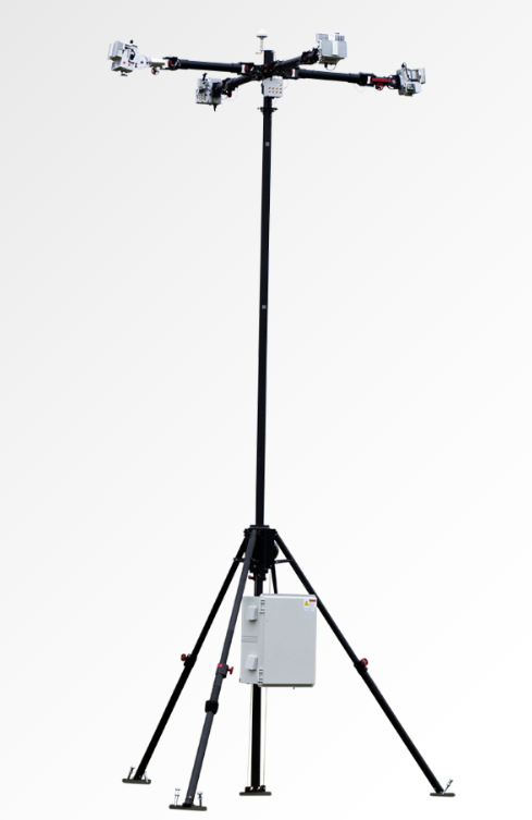
In the present phase of research, the GPSPatron team moved beyond land-based monitoring and installed itsGP-Probe TGE2 interference sensor directly on board a research vessel. The ship operated throughout the southern Baltic Sea, including regular approaches toward the maritime boundary of the Kaliningrad region.
By placing the sensor on a moving platform rather than a coastal location, they were able to record GNSS interference exactly as it affects real vessels — capturing signal conditions that cannot be observed from shore due to differences in radio horizon, antenna orientation, multipath environment, and proximity to potential interference sources.
The GPSPATRON probe TGE2 instaslled within the vessel’s equipment. (Photo: GPSPATRON)
Transition from classical jamming to combined spoofing-jamming interference
In contrast to the previous six-month coastal study, where all recorded GNSS interference consisted exclusively of multi-constellation jamming, the current shipborne campaign reveals a fundamentally different interference landscape.
All major events now present a dual-layer structure composed of:
GPS L1 spoofing, generating forged satellite-like signals, and
Simultaneous jamming of GLONASS, Galileo, and BeiDou.
This combined architecture forces GNSS receivers to rely solely on spoofed GPS signals while denying access to independent ranging sources. The practice is consistent with commonly used operational strategies: spoofing only one constellation (GPS) drastically reduces system complexity and cost, whereas spoofing all GNSS systems would require multiple parallel RF chains, SDR-based generators, algorithms for signal simulations and amplifiers.
Highest recorded levels of GNSS disruption
The most severe interference period occurred from late June through July, during which:
GNSS availability dropped to 83.5%,
4 days, 5 hours and 24 minutes of spoofing were recorded — by far the highest cumulative spoofing activity of the entire campaign.
The single most extreme incident took place between 1 and 3 July, with nearly 30 consecutive hours of spoofing within a 48-hour interval, posing a severe risk for maritime navigation.
In subsequent months the interference intensity gradually decreased, yet low-power and short-duration events continued to be observed.
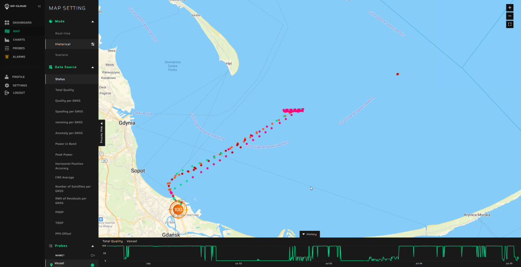
The area of the Baltic Sea the vessel patroled for GNSS interference. (Image: GPSPATRON)
A multi-emitter, synchronously operating interference network
Spectrogram analysis reveals that the interference does not originate from a single source but from four distinct, technologically different emitters operating in coordination:
The synchronous activation and termination of all four components indicate a centrally coordinated system, yet their differing spectral signatures, bandwidths, and stability levels confirm multiple spatially separated stations rather than a single unified installation.
This GNSS interference analysis shows interference intensity increases away from port. (Image: GPSPATRON)
Evolution of interference modulation techniques
A clear shift is observed compared to the previous study :
Previously, the dominant interference source consisted of a high-quality, purpose-engineered wideband signal with three clean constellation-matched components — an indication of modern, precisely designed jamming equipment.
In the current campaign, the prevailing interference is simpler wideband chirp jamming, a less advanced technique but deployed at significantly higher power levels.
The wideband analog-like component further shows pronounced parasitic frequency fluctuations, characteristic of older low-stability RF hardware.
This indicates a shift from high-precision jamming to a mixed environment of legacy high-power systems combined with newer spoofing capabilities.
Interference strongly intensifies offshore
A distinct spatial gradient was recorded:
In the Port of Gdańsk, interference appears weak or barely detectable.
As the vessel moves into open water, the same signals become up to 15 dB stronger.
The interference power consistently increases when approaching the waters facing Kaliningrad.
This pattern shows that — intentionally or not — the interference system affects maritime traffic far more than coastal infrastructure, with the operational impact being greatest in offshore navigational zones.
Download the full report using the form on this page.
Hoptroff, a precision timing specialist, has partnered with the London Stock Exchange (LSEG) through its Hosting & Connectivity Partner Platform, which enables financial markets customers to access third-party applications and services via LSEG’s global connectivity services.
The move reflects a fundamental shift in how financial services views timing infrastructure. No longer just a technical requirement, time has become a strategic investment in cybersecurity and digital resilience.
Timing precision has long been a regulatory necessity in financial markets. Rules such as MiFID II and FINRA CAT NMS define exactly how accurate trade timestamps must be. What’s changing is the expectation that timing infrastructure itself be resilient and independently verified.
Emerging EU and US guidelines now urge firms to mitigate over-reliance on GNSS/GPS and to implement terrestrial, traceable time sources that are protected against jamming, spoofing and cyberattacks. Time is under threat, and for financial institutions, dependable time is now a core element of regulatory resilience and audit confidence.
“Partnering with LSEG is significant,” said Tim Richards, CEO of Hoptroff. “As one of the world’s most influential financial institutions, their recognition of Hoptroff’s timing solutions demonstrates the strategic importance of resilient time that is easily accessible.”
Hoptroff combines precision timing with the reliability and uptime the sector demands, then pairs it with software that makes compliance straightforward. “Everything is plug-and-play, so firms get instant access without heavy upfront infrastructure costs,” Richards said.
Hoptroff addresses both established and emerging regulatory requirements for time synchronisation. The company holds ISO 27001 and ISO 9001 certifications and exceeds the precision standards financial markets require, offering accuracy across a terrestrial network that connects directly to national timing authorities, including NIST, NPL and RISE. This allows firms to meet global financial services regulations, such as MiFID II, FINRA CAT, and the EU Digital Operational Resilience Act (DORA), without sacrificing trading accuracy or uptime.
MatrixSpace has released the Portable 360 Radar, a rugged, easily transportable radar kit.
The Portable 360 Radar delivers reliable close-airspace awareness with panoramic coverage for rapid-response counter-drone operations, from safe-guarding stadiums and large public gatherings, to border security and battlespaces.
Traditional radar systems are cumbersome, slow to set up and limited in effectiveness for mobile C-UAS deployments, with high-power requirements. Instead, MatrixSpace Portable 360 Radar is low power, portable and affordable.
The MatrixSpace platform unifies threat awareness across multiple networked Portable 360 Radar systems and other sensors, without compromising local operation. By combining AI edge processing with MatrixSpace AiCloud Enterprise software, central command centers get an enhanced common operating picture and deep airspace activity analytics to assure public safety.
Major corporations and government agencies have adopted MatrixSpace Portable 360 Radar, which has excelled in rigorous C-UAS field testing including the U.S. Army’s recent xTechCounter Strike competition where it won best active sensor.
Key Features and Benefits
Low power, small footprint — a portable radar system easily transported by car that assembles in minutes.
Breakthrough affordability, enabling operators to catch hard-to-detect drones in challenging environments like dense cities and variable terrain.
Resilient AI edge-first architecture powered by sophisticated AI edge processing that continuously improves, assuring decisive operations even in congested environments.
Easy extensibility to MatrixSpace AiCloud — users can deploy one system or one hundred, all working together for enterprise command and control.
HERE Technologies has expanded its partnership with Precisely, a data integrity company, to provide accurate and reliable location intelligence for business use cases across industry sectors.
The partnership builds upon location intelligence capabilities within the Precisely Data Integrity Suite, giving companies deeper analysis, validation, and governance of their location data.
Through the partnership, HERE and Precisely use machine learning (ML) and artificial intelligence (AI) to collect and analyze location data, creating real-time updates that guide important business decisions like property management and analysis, among other business operations. The companies are working together to provide complete and accurate datasets to drive AI-powered intelligence for businesses.
The Precisely Data Integrity Suite delivers the trusted location intelligence that organizations need to power critical business decisions. The suite verifies, standardizes, and geocodes address data with high levels of accuracy and enriches it with robust contextual datasets. This combination of accuracy, consistency, and context helps businesses understand where things happen and why, enabling smarter risk assessment, optimized service delivery, and more targeted customer engagement. With governance and transparency built in, the Data Integrity Suite ensures location data is AI-ready and reliable for even the most regulated industries.
HERE’s Privacy Charter reinforces the company’s commitment to promote responsible privacy and security practices, including data minimization and anonymization. The company has a robust portfolio of certifications in security, privacy and cloud governance, including ISO 27001, SOC 2, TISAX, HITRUST r2, CSA STAR and ISO/IEC 42001, the first international standard specifically designed to guide organizations in managing AI systems responsibly.
New solution eliminates positioning errors in logistics, rail, and public safety by providing lane-level accuracy natively on rugged mobile devices.
Swift Navigation, a global leader in precise positioning technology, and RugGear, a manufacturer of rugged mobile devices for professional use, have joined to embed high-accuracy positioning capabilities into RugGear’s enterprise and mission-critical mobile devices.
The partnership integrates Swift Navigation’s Skylark Precise Positioning Service directly into RugGear devices built on the Qualcomm Snapdragon 6 Gen Platform. This native integration delivers reliable lane-level accuracy — an order of magnitude improvement over standard GPS — without requiring any external receiver or configuration. Precise positioning is available out of the box, ensuring seamless performance across rugged mobile form factors.
This integration is a major step in bringing high-accuracy positioning to industrial mobility. All location-based applications benefit automatically, meaning developers do not need to modify their existing apps.
Enhanced Capabilities with the RG940
The first device to integrate Skylark will be the RG940, a high-performance, rugged 10.1-inch tablet designed for demanding industrial uses. The high accuracy improves operational efficiency and accountability across enterprise segments, including:
Logistics and Waste Management. Optimizes routes, reduces fuel costs, and provides indisputable proof of service records for liability claims.
Construction. Provides a value-engineered approach for GIS mapping assets and enhances worker safety through geofenced “no-go” zones.
Rail. Enhances safety and efficiency for trains and prevents freight car loading errors.
Interested customers and partners are invited to contact RugGear directly for availability and technical specifications.
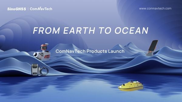
At a recent product launch event, ComNav Technology unveiled a new technological ecosystem for surveying. Under the theme “From Earth to Ocean,” the company presented a suite of next-generation innovations engineered to advance the frontiers of geospatial and hydrographic intelligence.
ML300 mobile laser scanning system
Precision surveying in complex environments
The ML300 mobile laser scanning system is designed for large-scale surveying projects and complex environments. It incorporates multi-mode fusion positioning technology, integrating GNSS, IMU, DMI and laser SLAM, providing a new approach to 3D scene reconstruction.
This system is designed for environments where GNSS signals are limited or entirely lost, such as tunnels, urban canyons, and densely built-up areas. In these challenging environments, traditional surveying methods often fail to deliver the required precision, but with ML300’s intelligent multi-mode positioning, we ensure accurate 3D scene reconstruction regardless of the conditions.
The ML300 mobile laser scanning system incorporates multi-mode fusion positioning technology. (Photo: ComNavTech)
The core advantages of the ML300 lie in its high precision and flexibility. By combining Laser SLAM and DMI technologies, it can operate effectively without GNSS signals, eliminating errors and improving modeling accuracy. This breakthrough offers new solutions for large-scale land surveys, urban infrastructure monitoring, and smart city planning, among others.
Designed for operational efficiency, the ML300 boasts a modular and highly flexible design. It can be customized with various sensors, including road cameras, Ladybug 6 panoramic cameras, and wheel encoders, making it adaptable to a wide range of project needs. Additionally, with up to 6 hours of battery life and external power source support, the ML300 ensures stable performance during long working hours.
Whether for highway surveys, urban power line inspections, dynamic forestry management, or smart transportation system development, the ML300 provides precise and efficient data support, facilitating digital transformation across various industries.
The SV3 USV is designed to be portable and usable by a single surveyor. (Photo: ComNavTech)
SV300 unmanned surface vessel
Intelligent underwater surveying
The SV300 unmanned surface vessel was designed specifically for intelligent underwater surveying. This autonomous vessel is optimized for operation in complex aquatic environments, integrating high-precision GNSS positioning, AI technologies, and autonomous navigation capabilities, enhancing both the efficiency and accuracy of hydrographic surveys.
Its design focus on making underwater exploration smarter, safer and more efficient. Its ultra-light design (28 kg) and compact hull (less than 1 meter in length) enable single-person operation. The SV300 can be stored in the trunk of a small vehicle.
Equipped with a high-performance single-beam bathymetric measurement system, the SV300 can measure depths up to 200 meters, ensuring reliable data. Its streamlined hull and powerful motor enable a top speed of 7 meters per second, accelerating survey speeds without compromising accuracy.
The intelligent features of the SV300 enhance measurement efficiency and ensure the safety of personnel. Whether used for river, lake or ocean surveys, or in emergency response and pipeline inspections, the SV300 adapts to complex environments inunderwater exploration.
HYD10 portable echo sounder
Compact and precise
The HYD10 is a lightweight, high-precision echo sounder designed for modern surveying tasks. Weighing 0.3 kg for the main unit and 1.5 kg for the transducer, its portability means a single operator to carry and operate. Its compact design and Bluetooth capability allow it to function seamlessly in tight spaces and complex environments, removing the need for cumbersome cables.
With a measurement depth range of 0.3m to 200 m, the HYD10 provides high-precision readings with accuracy ±1 cm + 0.1% of water depth and 1 cm resolution. The 200 kHz depth module and narrow 6° beam angle ensure precise, clear data, while an adjustable sound speed range (1300-1700 m/s) adapts to different water conditions.
For greater operational flexibility, the HYD10 integrates with Survey Master software, supporting real-time monitoring, data processing and wireless connections through Wi-Fi and Bluetooth. It is compatible with a variety of positioning devices, including the P6H and P8H tablets, as well as a wide range of RTK receivers. The P6H provides centimeter-level positioning accuracy, while the P8H offers flexible antenna adjustments for various field conditions.
The R80 GNSS Data Collector is designed for modern surveying. (Photo: ComNavTech)
R80 GNSS data collector
Precision in surveyors’ hands
The R80 GNSS data collector is designed to improve field technology, engineered for demanding tasks in construction, mining, surveying and GIS. The R80 has an octa-core processor, delivering rapid CAD and map loading to ensure smooth operation and boost productivity. The ergonomic design with an 18-degree grip angle maximizes one-hand comfort, reducing fatigue during long hours of operation.
The R80 features ultra-wide mechanical keys with tactile feedback, offering precise control with a 0.8 mm travel and pressure sensing. It includes custom quick-measure keys for easy access to measurement functions. The 51-key backlit keyboard and a 6-inch 1080P display ensure clear visibility even in direct sunlight. With a 9000 mAh battery, it supports more than 16 hours of continuous operation. It holds an IP67 rating for water and dust resistance and has passed a 1.5-meter drop test.
It supports 4G LTE, Bluetooth, Wi-Fi and NFC, and has a 13MP autofocus camera for high-definition imagery. Survey Master software, integrated with a CADX engine, enables instant opening of large drawings and ensures smooth field operations.
On Nov. 11, the chair of the Z-Wave Alliance, Avi Rosenthal, published an opinion piece in GPS World, urging a delay in addressing one of America’s most pressing national security and economic vulnerabilities. I am talking about the need for a terrestrial complement to GPS. By ignoring both the urgency of the threat and the strength of the engineering analysis supporting near-term solutions like 5G-powered 3D PNT, Mr. Rosenthal argues the U.S. can afford to wait. At NextNav, we strongly disagree.
Around the world, GPS disruptions are no longer hypothetical. As this publication has documented, incidents of GPS jamming and spoofing have become routine in places like the Middle East and the Baltic states. And the increasing severity of these disruptions is spilling over into civilian life, putting us all at risk. We’ve seen the consequences here at home, too. Major airports have experienced manmade GPS disruptions of unknown origin, and farmers have seen how even temporary GPS loss can upend precision agriculture.
Whether caused by jamming, spoofing or natural disasters, the vulnerabilities are real and growing.
These threats are why the Federal Communications Commission (FCC) made it a priority to advance additional technologies and solutions as part of a whole-of-government approach to strengthen PNT resiliency. At NextNav, we are doing the hard work necessary to help enable a system-of-systems capable of delivering greater PNT resilience into America’s critical infrastructure, while Mr. Rosenthal and his allies continue to rely on flawed studies and broad mischaracterizations of our proposal. They preach delay rather than moving to the logical next step of the FCC process, specifically designed to allow the commission to fully evaluate competing technical claims.
We have filed multiple comprehensive engineering studies demonstrating that 5G operations in the lower 900 MHz band will not cause unacceptable interference to unlicensed devices. Those studies specifically examined five different unlicensed technologies, including the Z-Wave technology. To ensure this discussion is fact-based, we’d like to set the record straight.
The SIA-sponsored paper that Mr. Rosenthal cited for his unrealistic claims of interference does not hold up under scrutiny and contains a number of fundamental technical errors. As we’ve outlined in detail, NextNav’s detailed technical analysis has identified significant flaws in the Pericle paper, pointing out fundamental errors in the paper’s assumptions and methodology.
For instance, Pericle’s predicted 5G emission levels exceed levels found in theoretical free-space conditions — an impossibility that undermines the entire paper. The Pericle paper also seems to ignore how 5G positioning signals work, failing to mention comb patterns and muting that are core to the technology, and thereby further inflating perceived 5G emission levels. Attempts to reproduce Pericle’s simulations with Pericle’s stated methods and parameters yield dramatically different results, which serve as clear evidence of computational errors or faulty execution of the depicted scenario.
Perhaps most remarkably, no credible analysis could replicate Pericle’s conclusion that 5G interference would occur more than 50 percent of the time when the ostensibly interfering transmitter operates only 50 percent of the time.
The most glaring issue with the paper that Rosenthal cites is that it never directly analyzes the very devices that the security industry states are predominant in home and business security systems today. Specifically, it fails to analyze Z-Wave, the technology that, according to the Z-Wave Alliance, is utilized by more than 90% of professionally monitored security systems in North America. In fact, Z-Wave operates primarily on frequencies that are outside of the frequencies which NextNav’s proposes to use for 5G.
It is a fact that unlicensed lower 900 MHz devices today successfully coexist with a wide range of unlicensed users that operate without coordination or interference protection. Pericle never accounts for the resilience mechanisms Part 15 devices use every day, including frequency hopping, bursty transmissions, adaptive modulation, redundant paths (meshing), self-healing and other features.
Lastly, Mr. Rosenthal’s characterization of the Department of Transportation’s action also fails to mention that the DOT has already evaluated NextNav’s technology, ranking NextNav first in every category of its 2021 evaluation. In 2024, DOT awarded NextNav the largest grant, $1.8M, for Rapid Phase I field testing of PNT technologies. NextNav supports DOT’s ongoing work to advance complements to GPS, but its testing should not stand in the way of swiftly advancing solutions that are ripe for action now.
Waiting for DOT to conclude its testing of multiple additional PNT technologies before the commission acts within its authority to take the next step towards enabling one or more potential solutions not only runs contrary to a Presidential Executive Order for agencies to remove barriers to private sector investment, but also risks the same analysis paralysis that slowed deployment of resilient PNT in the previous administration.
At NextNav, we are serious about solving an urgent national security problem, and we will continue to do the hard work necessary to support the FCC’s engineering-driven decision making. The FCC is the expert authority on commercial spectrum issues, and we believe it has all of the information it needs to take the next step in this process by issuing a Notice of Proposed Rulemaking (NPRM). Issuing an NPRM would also give the FCC the opportunity to ask any remaining technical or economic questions that it may deem necessary to complete its evaluation.
It’s time to roll up our sleeves and do the hard work necessary to enable a system-of-systems approach to building great PNT resilience. The longer we delay, the more vulnerable we become.
Renee Gregory is the vice president of regulatory affairs at NextNav.
Voyant Photonics is offering new versions of its Carbon lidar platform, adding 32-line and 64-line variants designed to bring the power of frequency modulated continuous wave (FMCW) sensing to more compact, cost-sensitive, and compute-limited systems.
The new models will be on display at the upcoming Consumer Electronics Show (CES 2026) in Las Vegas (LVCC West Hall, Booth #4875). Voyant will demonstrate live FMCW sensing capabilities and provide development kits for qualified partners.
The models complement the existing 128-line configurations, enabling broader choices and customizations from the Voyant portfolio of low-cost, high-performance sensors, and optimized for industrial autonomy, robotics, drones and smart infrastructure applications.
Building on the same efficient semiconductor foundation as Voyant’s flagship Carbon platform, the new versions offer lower data rates and simplified integration without sacrificing core FMCW advantages such as velocity measurement, interference immunity, and high dynamic range.
The Carbon family represents Voyant’s most versatile and scalable lidar product line, designed using Voyant proprietary silicon-photonics architecture that integrates beam steering and coherent detection on a single photonic chip. This integrated technology will unlock mass-production economics, reduced calibration drift, and unmatched consistency from unit to unit, the company said.
The new Carbon variants extend the core Carbon platform’s advantages:
High-precision depth sensing and real time velocity
Exceptional ambient light immunity, ensuring reliability from dim warehouses to direct sunlight
Compact design for demanding industrial and mobile environments
With line resolutions now spanning 32, 64 and 128, OEMs and system integrators can tailor performance, bandwidth and compute load to their specific use cases, from agile robotics and compact AGVs to drones and embedded edge platforms.
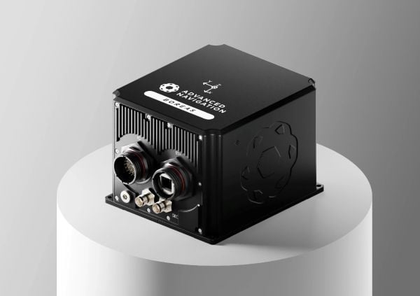
Advanced Navigation has finalized a multi-million deal with Kongsberg Defence & Aerospace to supply more than 50 Boreas D90 fiber-optic gyroscope inertial navigation systems (FOG INS) to strengthen Kongsberg’s Protector RS4 in high-threat, contested environments.
As a strategic-grade INS, the Boreas D90 is engineered for the world’s most extreme environments, maintaining exact targeting and unwavering line-of-sight control for the Protector RS4.
The Boreas D90 was selected not only for its superior precision in GNSS-denied conditions, but also for Advanced Navigation’s proven capacity to meet demanding delivery timelines. This agility is made possible by the company’s state-of-the-art, vertically integrated manufacturing. By controlling the entire production process, from sourcing raw components to assembly and testing in simulated EW environments, Advanced Navigation can rapidly scale output on demand and guarantee schedule certainty, a critical factor for Kongsberg.
The Protector RS4 remote weapon system. Photo: Kongsberg)
The Protector RS4 is the world’s most fielded remote weapon system, deployed across more than 30 nations and multiple domains. The highly flexible, modular system is designed to integrate a diverse range of payloads, including small and medium caliber systems and guided effectors. Its advanced, modular sensor suite (day, night, LRF) provides exceptional and customizable situational awareness.
The fully stabilized 2 + 2 axis (detached line of sight) system allows the operator to maintain focus on a point of interest, independent of platform movement or the delivery solution for the specific system in use. The Protector RS4 is platform-independent and suitable for both land and sea applications.
By integrating Boreas D90, the Protector RS4 achieves a new level of precision and survivability, sustaining locked targeting and georeferenced stability even when GNSS is compromised or denied. This enhancement positions Kongsberg’s Protector RS4 as one of the few systems globally capable of maintaining precision pointing under active electronic warfare attack.
The deal supports the Global Supply Chain (GSC) Program, an initiative by the Australian Department of Defence designed to connect local suppliers with major global defense prime contractors. Advanced Navigation is based in Australia; Kongsberg is based in Norway.
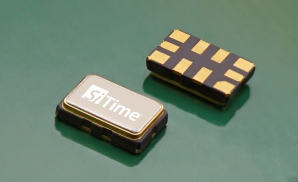
Endura Super-TCXO Delivers Superior Holdover and Ruggedized Performance for Aerospace, Defense and Industrial Applications
SiTime Corporation has launched the Endura temperature-compensated oscillator (Super-TCXO), ENDR-TTT, for position, navigation and timing (PNT) applications. Engineered for superior holdover — uninterrupted operation when GNSS is not available — and resistance to jamming and spoofing, ENDR-TTT is an ultra-stable, low-power product for GNSS receivers in aerospace, defense and industrial markets.
“SiTime’s Endura Super-TCXO, ENDR-TTT, allows us to create a multi-layer anti-spoofing methodology,” said Paul McBurney, GPS World Editorial Advisory Board member, CTO and co-founder at OneNav. “The first layer minimizes the search window, preventing spoofing because signals outside the window are never tracked. The second layer addresses exceptionally large search windows, such as in first acquisition, where spoofers can be tracked. In this case, the spoofer signals can be identified and removed due to SiTime’s ultra-stable reference clock.”
When GNSS signals are dropped because of unavailability or degradation — including signal jamming or extreme environmental conditions — holdover maintains timing stability locally to enable uninterrupted network operation. The ENDR-TTT Endura Super-TCXO provides up to 20x longer holdover and 20x better PNT accuracy, dramatically improving spoofing resistance.
“SiTime’s ENDR-TTT Endura Super-TCXO accelerates GNSS recovery by narrowing the resynchronization window, reducing spoofing and setting a new standard for ruggedized precision timing,” said Piyush Sevalia, executive vice president of marketing at SiTime. “Our latest product delivers a powerful combination of superior performance, low power and small size, that leads the industry for PNT applications.”
Additional features for SiTime ENDR-TTT Endura Super-TCXO include:
±50 ppb stability over temperature (FvT); up to 10x better frequency stability over temperature versus quartz alternatives.
-55ºC to +125ºC operating temperature range.
30,000 g operational shock; up to 20x better resistance to shock.
0.004 ppb/g typical g-sensitivity; up to 50x better than quartz alternatives.
±0.5 ppm 20-year aging—eliminates field recalibration.
Optional I2C/SPI digital pulling capability for system frequency fine-tuning.
SiTime’s ENDR-TTT is sampling now. Mass production is expected in the first quarter of 2026.
SpacePNT SA, a global provider of high-accuracy, radiation-tolerant spaceborne GNSS receiver equipment for missions ranging from Earth to cislunar orbit, has completed extensive qualification testing of its second-generation product, including vibration, shock, thermal vacuum and electromagnetic compatibility tests.
The multi-frequency, multi-GNSS receiver resulted from two European Space Agency (ESA) ARTES Competitive & Growth (C&G) development projects supported by ESA and the Swiss Space Office.
The first project enabled SpacePNT to develop an industrialized second-generation product for large-scale production targeting low-Earth orbit, LEO position-navigation-timing and geostationary orbit telecommunications constellations. The receiver includes a proprietary Precise Orbit Determination algorithm that provides sub-decimeter real-time positioning and timing aboard spacecraft. The company validated the POD algorithm in a hardware-in-the-loop environment and retrofitted it into two first-generation flight models delivered to a customer for satellite integration.
Under the second project, SpacePNT developed a Radiation Hardiness Assurance approach for long-duration missions in harsh radiation environments. ESA’s GENESIS satellite mission, which will operate in a challenging medium Earth orbit environment, will be the first to use this RHA approach. SpacePNT will supply the mission’s GNSS receiver equipment.
Though the second-generation receiver uses largely the same hardware, software and firmware technology as the company’s flight-proven first-generation product, SpacePNT performed a complete qualification campaign to validate design changes.
After passing all qualification and performance tests, SpacePNT will begin manufacturing first flight models of its second-generation products for several customers. The receivers will fly on demanding Earth observation, in-orbit servicing and space exploration missions at altitudes from LEO through medium Earth orbit, geosynchronous transfer orbit, geostationary orbit and lunar distances.
The views expressed herein do not reflect the official opinion of the European Space Agency.