Dual-frequency timing module provides anti-jamming and anti-spoofing capabilities
Photo: Trimble
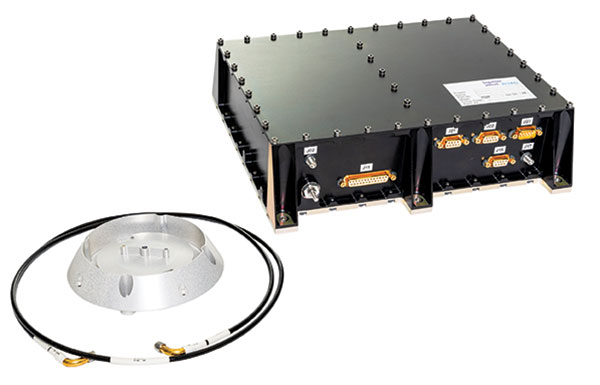
Trimble has introduced its first dual-frequency embedded timing module that provides next-generation networks with 5-nanosecond accuracy.
Surface mountable, the Trimble RES 720 GNSS timing module can be integrated into network equipment. It uses L1 and L5 GNSS signals to provide superior protection to jamming and spoofing, mitigates multipath in harsh environments, and adds security features to make it suitable for resilient networks.
Precise timing and synchronization optimizes and improves wireless network performance. At 19 x 19 millimeters, the RES 720 module provides a low-cost, easy-to-use, highly accurate and reliable GPS timing source for critical infrastructure in a broad range of industries. The RES 720 is suitable for 5G Open RAN/XHaul, smart grids, data centers, industrial automation and satellite communication networks, as well as calibration services and perimeter monitoring applications.
The RES 720 meets the resilient timing requirement mandated by the U.S. 2020 Executive Order (EO13095) for timing services and critical infrastructure operators. Using dual-frequency (L1 and L5), RES 720 provides better multipath detection capabilities than single frequency, and provides protection against signal jamming and spoofing. Multi-band capability helps compensate for the ionospheric error from multi-GNSS satellite constellations, while reducing the timing error under clear skies to less than 5 nanoseconds. To further improve its accuracy locally, the RES 720 module features differential timing modes for highly accurate local timing.
Powered by Trimble’s Smart GNSS Assurance technology, the RES 720 offers protection against jamming and hacking of signals with automatic fallback to available GNSS signals. Infrastructure equipment suppliers, system integrators and network operators can benefit by integrating highly accurate synchronization capabilities into their network and synchro-phasor devices, while enabling resilient timing for critical infrastructure.
The RES 720 is expected to be available in the second quarter of 2021.
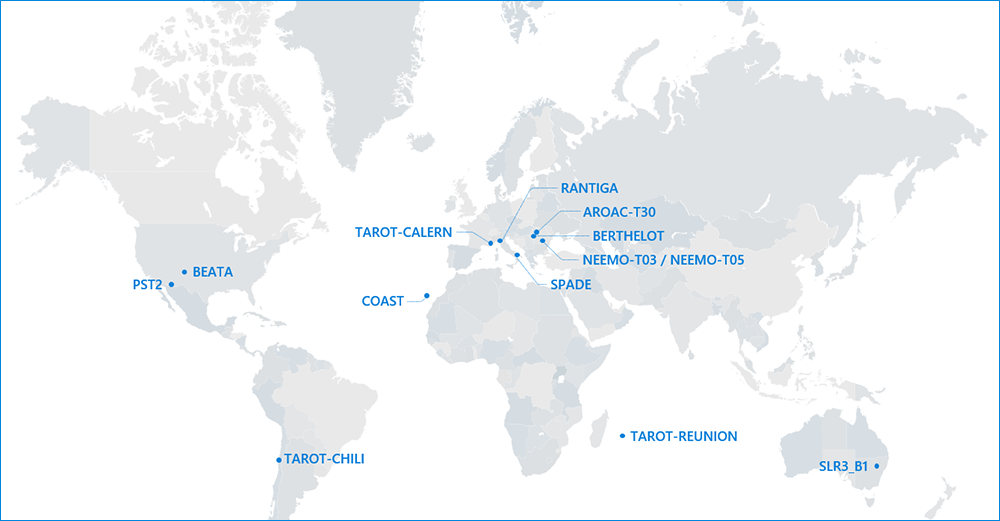
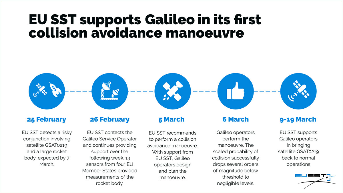
On Feb. 25, the Galileo Service Operator (GSOp) received from EUSST a collision risk alert between GSAT0219 and an inert Ariane 4 upper stage launched in 1989. Following the warning, GSOp closely monitored the risk, in close cooperation with EUSST that was refining its predictions.
In line with operational procedures, GSOp informed the GSA of the situation. In a joint effort with the European Commission, the GSA managed the follow-up activities. The effective cooperation between EUSST and the GSA/GSOp was instrumental to the success of the mission and bears testimony to the need for efficient cooperation between different organizations in the space sector.
Maneuver Authorized
Following refinement of the Ariane 4 orbit, the risk of collision was still unacceptably high. After assessment of different strategies and associated risks on the service provision, the GSA authorized the execution of an avoidance maneuver.
The satellite was taken out of service on March 5, and users were informed via NAGU #2021009. The collision avoidance maneuver was performed shortly thereafter, by temporarily relocating the satellite away from its nominal position.
Satellite GSAT0219 was reintroduced into service on March 19 after the completion of two station-keeping maneuvers to reposition it into its nominal operational orbit. A second NAGU advised users that the satellite was once again available.
Map of sensors contributing to the event. (Image: EUSST)
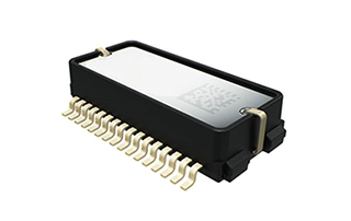
Murata has developed a new (micro-electro-mechanical systems (MEMS) six-degrees-of-freedom (6DoF) inertial sensor for GNSS positioning support, autonomous off-highway vehicles and dynamic inclination sensing. Murata’s new SCHA63T sensor is a single package 6DoF component. It can enable centimeter-level accuracy in machine dynamics and position sensing, and can assist in ensuring safe, robust and verified designs.
The sensor enables further advancement in technology and novel solutions for GNSS-based measurement instruments, advanced driver/operator assistance systems, and autonomous vehicles.
The product delivers highest performance available on the component level in the key parameters of bias stability and noise. Murata calibrates orthogonality of all measurement axes, which allows customers and system integrators to skip that critical process step.
A key focus area in product development for SCHA63T has been to ensure operation during high mechanical shock and vibration. Within the same product family, sensor variants are qualified according to the automotive AEC-Q100 standard. The SHCA63T sensor includes advanced self-diagnostic features and can achieve full compliance with ASIL-D (Automotive Safety Integrity Level-D).
The SCHA63T sensor features extensive failsafe functions and error bits for diagnostics. These include internal reference signal monitoring, checksum techniques for verifying communication, and signal saturation/over range detection.
The diagnostic feature of Murata’s three-axis accelerometer is the continuously operating self-test function, which monitors the sensor during measurement. This patented self-test function verifies the proper operation of the entire signal chain, from MEMS sensor element movement to signal conditioning circuitry for every measurement cycle. Even if the system using SCHA63T is not required to follow international functional safety standards, the provided design support documentation enables for customers a cost effective, robust and fast design process.
Murata, based in Japan, has more than 20 years of experience of providing inertial sensors for safety-critical automotive applications like electronic stability control.
Oxford Technical Solutions has released the xNAV650, the latest in its line of inertial navigation systems (INS), suitable for use on drones.
INS provide surveyors with absolute position, timing and inertial measurements (heading and pitch/roll) that they can integrate into their survey projects. The measurements, when combined with data from other devices (such as lidar sensors and cameras), can greatly enhance the surveying process, leading to a greater return on investment, according to the company.
The xNAV650 is OxTS’ smallest, lightest and most affordable INS to date. It combines 20 years of navigation experience with the latest micro-electromechanical (MEMS) inertial measurement unit (IMU) technology and survey-grade GNSS receivers.
UAV Guidance
The xNAV650 provides highly accurate and reliable measurements – even when payload size and weight are imperative to consider, including for use with unmanned aerial vehicles (UAVs). It measures 77 x 63 x 24 mm and weighs 130 grams.
The xNAV650 INS is suitable for a wide range of UAV data-collection applications, including surveys of bridges, buildings, forests and rail; coastal monitoring; map creation and pipeline exploration.
OxTS’ partner Dronezone used the xNAV650 INS and a Velodyne VLP-16 lidar on a drone to conduct a scan of an aging bridge to look for structural and potential hazards from overgrown foliage.
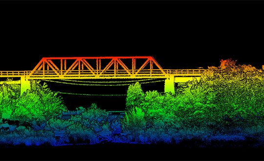
By fusing the timing, position and inertial data from the INS with the raw data of the Velodyne VLP-16 (using OxTS’ lidar georeferencing software OxTS Georeferencer), the surveyor was able to produce a highly accurate 3D point cloud of the bridge. Fusing the position and inertial data from the xNAV650 INS with the Velodyne VLP-16 lidar data provides a high level of clarit, which can be seen in the foliage, electricity lines and side of the bridge.
The resulting point cloud has enabled the engineers to easily and accurately pinpoint areas of the bridge that need closer attention.
Side view point cloud of bridge. Data collected using and OxTS xNAV650 INS and Velodyne VLP-16 lidar. Data processed using OxTS Georeferencer. (Image: OxTS)
NAVsuite Software
Data from OxTS INS can be fused with the data from almost any lidar sensor. Using OxTS Georeferencer software, point clouds can be georeferences from lidar units specifically from Velodyne, Hesai and Ouster sensors. Work is underway to integrate new lidar sensors from an even wider range of manufacturers into OxTS Georeferencer – allowing OxTS INS users to build a full navigation solution where much of the integration work is already taken care of.
OxTS NAVsuite software is included with all OxTS INS. The full range of software tools allows users of OxTS’ devices to configure and post-process data with ease.
Other optional software features are also available, including Precision Time Protocol (PTP) and GX/IX tight-coupling technology. PTP allows for a much simpler lidar survey set-up over ethernet while simultaneously stamping out time-drift by utilizing the high-quality INS clock source – GNSS. GX/IX tight-coupling technology, OxTS’ own proprietary navigation engine, ensures that users of OxTS Inertial Navigation Systems receive the most accurate measurements possible even in tough GNSS conditions.
Mapping company ProStar Holdings Inc. and survey device company Bad Elf have partnered to produce a solution designed to gather the precise location of surface and subsurface utility data.
PointMan combined with Bad Elf is designed to quickly and precisely, locate, identify and display critical surface and subsurface utility data.
Bad Elf’s survey-grade GPS/GNSS receiver combined with ProStar’s flagship mobile-mapping solution, PointMan, now provides a powerful and user friendly solution for any industry requiring precision mapping including subsurface utility engineering (SUE) and utility locating professionals.
“The Bad Elf Flex was quickly configured by ProStar and performed flawlessly with the PointMan app. We found that consistent high accuracy was easy to maintain while collecting data,” said Larry Fox, vice president of marketing and business development at Bad Elf. “The depth of collection tools and export facilities exceeded our expectations. Given the seamless integration with Bad Elf Flex, PointMan demonstrated it’s a top-tier app for utility management, and expands our ability to provide best in class solutions to our users worldwide.”
“Equipment manufacturers like Bad Elf and their distribution networks are an important component of our sales and marketing strategy,” said Page Tucker, CEO and founder of ProStar. “Our goal is to continue to work with leading equipment manufacturers around the world to provide the most comprehensive, modern, and low-cost data collection solutions.”
ProStar’s flagship product, PointMan, is natively cloud and mobile, offered as a Software as a Solution (SaaS). ProStar’s solutions are being adopted by some of the largest entities in North America, including Fortune 500 construction firms, the largest subsurface utilities engineering (SUE) firms, and government agencies.
ProStar’s strategic partnerships are with geospatial technology and data-collection equipment manufactures and their dealer networks, including Trimble, Juniper Systems, Vivax-Metrotech, Radiodetection, Bad Elf and Subsite Electronics.
Advanced Navigation, in partnership with quantum technology company Q+CTRL, will create a quantum-enhanced inertial navigation solution for space launch vehicles, satellites and landers. The design of this inertial navigation technology for long-endurance space missions will be pivotal to NASA’s space exploration initiative, the Artemis Lunar Exploration Program.
The work will be done under a Moon to Mars Supply Chain Capability Improvement grant by the Australian federal government.
The quantum-enhanced navigation system will enable NASA and its partners in the international space exploration community to execute deep space, lunar and planetary missions that were previously not possible.
Artemis is NASA’s human lunar exploration plan, with the program aiming to send the first woman and next man to the surface of the Moon by 2024. Scientists have long acknowledged the Moon as a rich source of information regarding Earth and the Solar System. Using the findings from the Moon. NASA will then prepare to launch missions to Mars.
To meet NASA’s space exploration initiatives, high-end, highly accurate inertial navigation technology is vital to the mission’s success. The groundbreaking inertial navigation systems developed by Advanced Navigation have been recognised by the international aerospace community as a superior technology to help pioneer a new age of space exploration and discovery for humanity.
For Advanced Navigation, this is just the beginning. “In the long-term view of this critical initiative, team activities following this project will establish an ongoing manufacturing opportunity and capacity that is central to the emerging Australian space industry,” said Chris Shaw, co-CEO of Advanced Navigation.
Advanced Navigation was founded in Sydney in 2012 by engineers Xavier Orr and Chris Shaw to commercialize thesis research into AI neural network-based inertial navigation. The first product met the market with great success and the company expanded rapidly adding a portfolio of navigation offerings and moving into a diverse range of deep tech fields such as underwater acoustics, GPS, radio frequency systems, sensors and robotics.
Today Advanced Navigation is a supplier to companies including Airbus, Boeing, Tesla, Google, Apple and General Motors. Advanced Navigation is headquartered in Sydney with a large research facility in Perth and sales offices around the world.
Why permissions and regulations are an important part of workflows
By Pierre-Alain Marchand Regulatory Compliance Manager, senseFly
Pierre Alain Marchand
Now widely accepted as a mainstream commercial mapping tool, the benefits of using drones to make better-informed decisions and provide a robust return on investment are well understood.
But progress in drone technology is shifting the focus to more advanced operations, a term that encompasses a wide range of activity, including beyond-visual-line-of-sight (BVLOS) flights and operations over people (OOP), as well as flying at night, as part of a fleet, or in restricted airspace.
These types of flights typically require more planning and permissions, but both can help improve safety for people on the ground, as well as create long-term cost savings and improve data-collection efficiencies.
Part 107 Waivers. However, while the benefits of advanced drone operations are increasingly well recognized, navigating these differences can be complex.
For instance, the Federal Aviation Administration (FAA) requires all companies planning advanced drone operations to complete a Part 107 waiver, an official document that approves certain operations of aircraft outside the limitations of regulation.
However, of the thousands of applications completed in 2018, only 23 were approved. Despite these poor figures, progress is being made to help make the approvals process more accessible.
Testing. Drone testing has been key to getting operations to where they are today — and will continue to play a role when demonstrating how the required safety, regulatory and logistical criteria of advanced drone operations can be met. Its importance should not be underestimated; testing has the potential to speed up regulatory procedures and even expand drone operations.
For that reason, investing in drone testing remains a priority today — the more data that is made available to backup a drone’s durability and reliability, the more evidence there is that the technology is safe and fit-for-purpose. SenseFly fixed-wing drones, for example, have thousands of hours of safety testing behind them, which is vital for streamlining and accelerating the approval of waiver requests and flight permissions.
Testing can also create more opportunities within the project scope, for instance by allowing operators to fly in more built-up areas.
Permissions. Although testing plays a key role in establishing regulatory compliance, it is still only one piece of the puzzle. With the rules for flying changing all the time, there is also the issue of navigating complex flight permission processes, which vary between countries.
The good news is that we are now seeing authorities across the world taking measures to streamline the regulatory process and make the rules clearer for operators. For example, the FAA has recently launched its new BEYOND program, which will support efforts to move toward BVLOS operations being carried out under established rules rather than waivers. Type certification is also becoming increasingly important in the U.S., which may further signal a potential move away from waivers in the future.
It’s promising to see the issue of regulatory compliance and flight permissions being placed at the top of authorities’ agendas. Connections are vital. Working in this way is a two-way process: both parties want to learn more about advanced drone operations and streamline the administration requirements.
Although there is still work to be done to ensure advanced drone operations become more accessible, the industry is moving in the right direction. As the approval process becomes easier, we predict more commercial companies will see the value of these operations and begin implementing them in their workflows.
Pierre-Alain Marchand is a regulatory compliance manager at senseFly , a commercial drone subsidiary of Parrot Group. For more information, visit the website or contact Marchand at [email protected].
On March 20, a South Korean Earth Observation satellite will be sent to space, carrying a navigation receiver from RUAG Space to determine the satellite’s position in orbit. The Earth Observation satellite is being launched by the Korea Aerospace Research Institute (KARI), South Korea’s space agency.
The precision single-frequency low Earth orbit GNSS receiver, called LEORIX, is a GPS + Galileo receiver from RUAG Space’s new generation of receivers.
More than 80 RUAG Space receivers of the latest generation (LEORIX for Low Earth Orbit, GEORIX Geostationary Orbit and PODRIX) have been ordered by customers in Asia, Europe, Middle East and the United States. They will be launched for various low and geostationary Earth Orbit missions within the next few months and years.
Currently, 22 navigation receivers from RUAG Space are in orbit. The satellite CAS-500-1 will be launched aboard a Russian Soyuz-2 launch vehicle from the spaceport in Baikonur, Kazakhstan.
After the launch of CAS-500-1, South Korea plans to send the CAS500-2 satellite to space. A launch date of this second mission is not yet defined. The CAS500-2 mission also will fly with a LEORIX receiver from RUAG Space. The satellite builder — Korea Aerospace Industries (KAI) — already has received the space-borne navigation receiver.
PODRIX in Space
Since November 2020, two new Precise Orbit Determination Receivers (PODRIX) from RUAG Space have been in orbit. They determine the position of ocean-monitoring satellite Sentinel-6.
The PODRIX GNSS spaceborne receiver achieves a very high, real-time in-orbit accuracy of the satellite’s position in orbit from below one meter to a few centimeters using on-ground post-processing. The high accuracy is achieved through simultaneously processing of multi-frequency signals from GPS and Galileo.
PODRIX GNSS spaceborne receivers are built on the experience of the more than 20 GPS-only receivers of the RUAG Space legacy receiver generation now in orbit.
The receivers precisely determine the position of a satellite once in orbit, which improves the satellite’s performance. Sentinel-6 measures the sea level on a global scale with unprecedented accuracy, which is crucial for climate change research. Every millimeter or centimeter in further precision highly improves the performance of the mission. The more precise the Sentinel-6 spaceborne GNSS receiver from RUAG Space works, the more precise are the data of this climate mission.
RUAG Space is a supplier to the space industry in Europe, and has a growing presence in the United States. It develops and manufactures products for satellites and launch vehicles, playing a key role both in the institutional and commercial space market. RUAG Space is part of RUAG International, a Swiss technology group focusing on the aerospace industry.
A new enterprise platform available this summer provides real-time location and asset tracking across a campus with Bluetooth technology.
Link Labs’ AirFinder OnSite is an internet of things (IoT) asset-tracking platform for campus-based environments. Using a Bluetooth Low Energy (Bluetooth LE) radio to support both Bluetooth LE and phase ranging brings location accuracy with Bluetooth LE tags to the sub-meter level.
According to Link Labs CEO Bob Proctor, AirFinder OnSite eliminates the need to choose between high-cost/high-accuracy ultra-wideband solutions or low-cost/low-accuracy traditional Bluetooth LE solutions.
Proctor sees it potentially used in distribution centers and warehouses, as well as IoT applications in manufacturing, healthcare and logistics management. With seven patented or patent-pending Link Labs technologies, AirFinder OnSite was developed on Nordic Semiconductor’s nRF52833, a general-purpose multiprotocol system-on-chip with a Bluetooth LE direction-finding-capable radio.
Innovations at the firmware level solve an array of technical challenges for an enterprise-grade solution: ranging methodology, interference avoidance, a location algorithm, power efficiency and scalability to high-tag densities.
These innovations allow asset location to be fine-tuned to the sub-meter level, making it a precise Bluetooth-based location technology.
AirFinder does not require an internal Wi-Fi system and is capable of operating on its own secure network layer via Link Labs’ Symphony Link or other third-party network layer technology, such as Bluetooth mesh technologies. The AirFinder platform provides remote monitoring and device management, allowing the system to be optimized for different use cases.
This spring, early adopters will support pilot deployments of AirFinder OnSite.
Critical infrastructure services such as telecommunications, utilities, transportation and defense are of national strategic importance. The U.S. Cybersecurity and Infrastructure Security Agency (CISA) lists 16 such sectors considered vital for security. Presidential Policy Directive 21 (PPD-21): Critical Infrastructure Security and Resilience advances a national policy to strengthen and maintain secure, functioning and resilient critical infrastructure.
Together, positioning, navigation and timing (PNT) are necessary for the functioning of a nation’s critical infrastructure. However, ubiquitous use of GPS as the primary source of PNT information introduces vulnerabilities. CISA, through the National Risk Management Center, works with government and industry partners alike to strengthen the security and resiliency of the national PNT ecosystem in the U.S. In early 2020, Executive Order (E.O.) 13905 on Strengthening National Resilience through Responsible Use of Positioning, Navigation, and Timing (PNT) Services was signed to strengthen, through policy promotion, the responsible use of PNT services by government and infrastructure operators.
The following is a review of cost considerations and exploration of the three key elements for critical infrastructure that help to strengthen PNT, focused on synchronization and precise timing: redundancy, resiliency and security.
Evaluating Cost and Location
It is often hard for operators to justify the resiliency, redundancy and security costs associated with deploying these capabilities at every layer of the architecture. New timing and synchronization solutions and design choices are leading to the right cost structures to deliver robust and reliable solutions.
The dilemma between cost and solution type is typically related to which deployment location is considered. With the evolution of technologies such as the migration from SDH/TDM to Ethernet and the development of LTE/4G and 5G in mobile, the number of aggregation offices and, above all, of network access sites at the edge has exploded. This inevitably leads to devices becoming much smaller, typically 1U-rack mountable devices, and with a cost in line with the much smaller size of edge base stations (small cells and gNodeBs).
Operators are left with the question: What is the best way to provide redundancy, resiliency and security in this environment? There are two core levels to consider — the architecture level and design level.
Exploring Redundancy
Redundancy at the architecture level can be engineered with core functions at both ends of a deployment (east/west) with dual paths for directional redundancy and high-performance capabilities for efficient high-accuracy time transfer over the long haul for cost-effective distribution. The virtual Primary Time Reference clock (vPRTC) architecture is such an architecture-level solution.
Redundancy can also be considered in the device itself, where the design choices are critical. Smaller devices cannot realistically be cost-effectively designed with modular hardware redundancy. The innovation here is to offer software redundancy, so a distributed, low cost, efficient and high-performance distributed solution can be deployed. A hardware module is typically expensive for two reasons: cost, and because the redundant module takes the space of another module, typically for input and output ports.
Hardware module redundancy often leads to a tradeoff between adding redundancy and losing capabilities, such as a choice between 10-gigabyte Ethernet (GE) support or multi-band GNSS or other compromises if redundancy is enabled. On the other hand, with software redundancy no tradeoff is necessary. Redundancy can be introduced while preserving all existing capabilities; no inputs or outputs are eliminated, no multi-band GNSS capability is eliminated. Redundancy is introduced via a software upgrade; therefore, it does not remove any hardware. Hardware redundancy, however, means duplicating an existing module with a similar module inside the device; this new module takes the slot of an existing module, and the function of that existing module is lost when it is removed from the unit.
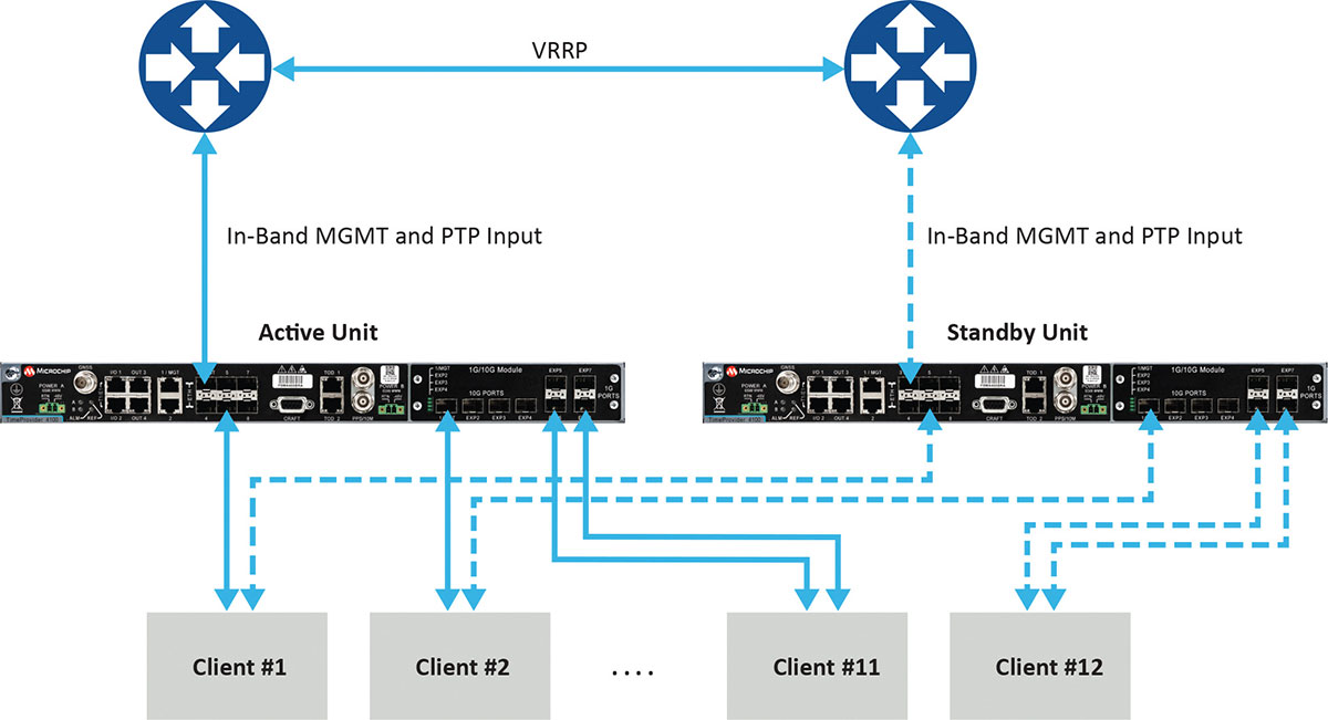
Figure 1 depicts a commonly deployed redundancy use case with two aggregation routers using virtual router redundancy protocol (VRRP).
Figure 1. Example of redundancy connectivity between the active and standby units. (Image: Microchip)
Software redundancy is a dual-unit scheme based on two reasonably priced devices, one active and the other on standby. It is more cost-effective for two reasons. First, it does not involve a costly device design with expensive hardware modules. Second, each unit (passive and active) keeps all of its capabilities compared to a hardware redundant design, which involves duplication of modules in the device, thus reducing the existing possible capabilities to host the redundant module.
Software redundancy provides total redundancy of the whole device because the active and standby units are the same. One hundred percent of the capabilities are redundant, including oscillator, GNSS receiver, ports and input/outputs. A hardware module is only redundant for its own features, not the rest of the unit.
Leveraging Resiliency
Resiliency at the architecture level is key to engineering the network so grandmasters in the deployment can be connected to each other. Some grandmasters are connected to GNSS as their source of time and frequency. It is key to connect these systems to other 1588 grandmasters to enable assisted partial time support (APTS) and to leverage key innovation such as automatic asymmetry correction (AAC).
AAC is a key (patented) differentiator in a resilient design that enables calibration of the different paths a PTP flow may use to/from upstream grandmasters, thus allowing for a backup in case GNSS fails at the location of a grandmaster. A backup path to an upstream grandmaster can guarantee uninterrupted and precise time and phase operation. This architecture makes sure that GNSS can be backed up by IEEE 1588 Precision Time Protocol (PTP) when GNSS is interrupted, with the best path being utilized.
The alternative architecture choice is virtual PRTC (vPRTC), which enables operators to leverage redundancy and resiliency via a chain of high-performance boundary clocks using PTP over long distances for high accuracy, typically over optical networks. This architecture reduces reliance on GNSS and uses PTP as its primary source of time and phase.
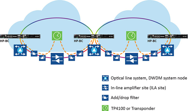
Figure 2 depicts an optical network deployment with a dedicated optical timing channel (OTC) for high-accuracy distribution of phase over long distances.
Figure 2. Optical network deployment with OTC. (Image: Microchip)
Resiliency at the device level starts with the right choice of an oscillator, from OCXO to atomic clock (Rubidium) — and is dependent on the location, use case and respective requirements for timekeeping holdover performance. Also, the choice of GNSS receiver is key. Some typically support a single frequency, yet ionospheric phenomenon can create significant time delays during cyclical events such as solar storms. To mitigate such delays, a multi-band GNSS receiver is required.
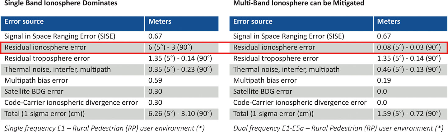
Figure 3 depicts a comparison between single-band and multi-band time delays due to ionospheric effects and shows how multiband clearly mitigates the time error as highlighted in red.
GNSS satellites transmit time information in several frequency bands. The delay difference between signals at different frequencies provides information about ionospheric impact on the absolute delay. This enables multi-band GNSS receivers to compensate for delay variations of radio signals transmitted from the satellite to the receiver. Embedding a multi-band receiver mitigates these time delays, which is critical for applications requiring Primary Reference Time Clock class B (PRTC-B),40 ns, as well as enhanced PRTC (ePRTC) 30 ns.
These device design choices are equally important. The GNSS receiver can be embedded inside the unit on the main board, or it can be offered as a hardware module, often at an additional cost, and may impact and replace an existing module that needs to be ripped and replaced. It may be preferable to have the unit enabled with a multi-band receiver and have the multi-band capability turned on via a license as opposed to offering a multiband option on a hardware module, as this becomes a tradeoff with other important capabilities.
Evaluating Security
Security is of utmost importance. Authentication and authorization via standard mechanisms such as Terminal Access Controller Access Control System + (TACACS+) and Remote Authentication Dial-In User Service (RADIUS) provide the benefit of a standard security framework. In addition, two-factor authentication (2FA) is an extra layer of protection used to ensure the security of accounts beyond just a username and password.
Also, it is key to provide Secure Shell (SSH) extensions with various levels of security profiles to offer more granularity for the types of users and related access rights and limitations. Offering high-security profiles provides for the definition and enforcement of the most stringent access rules to the system. Scripting vulnerabilities and relevant Common Vulnerabilities and Exposures (CVE) need to be addressed to make sure all potential security holes are being reviewed and addressed.
Plus, evolving jamming and spoofing threats need to be part of the precise time security strategy and implementation via monitoring of signals and consistency checks and remediation. Automatic gain control (AGC) and other metrics can be leveraged to provide thresholds with interpretation of results, as well as mitigation actions when encountered.
Final Decision Making
To ensure continued performance, it is critical to make the right architecture choices. A thorough network engineering study should include the locations where grandmaster units need to be deployed and their performance and accuracy requirements. These steps will guide which types of precise time and synchronization devices need to be selected
In addition, network planners and synchronization engineers should pay careful attention to design choices such as fanless devices versus devices that require a fan, modular hardware redundancy versus software redundancy, and the related advantages in terms of cost and tradeoffs — as well as similar choices regarding embedded or modular GNSS.
These choices can lead critical infrastructure operators to deploy redundancy, resiliency and security at all layers.
For architecture choices and solutions, visit vPRTC..White papers on this topic and others are also available. Additional information on devices and redundancy software schema is here.
Eric Colard is head of Emerging Products, Frequency & Time Systems at Microchip. He leads the product line management for Microchip’s TimeProvider 4100 and Integrated GNSS Master solutions for the telecom, utility and other industries.
What is the single most valuable lesson GPS can learn from Galileo and/or BeiDou?
Bernard Gruber
“Service continuity. Given that GNSS are so ubiquitous today, similar to the electrical grid, it is imperative that GPS continue the superb system of outage reporting via NANUs, transparency via GPS.gov, and statutory commitments via U.S. Code. Aligning to the U.S. commitment, continued Open Service Signal-in-Space, such as GPS-Galileo-BeiDou, allows thousands of planned and interoperable “apps” such as Google Maps and Waze to thrive. Although not directly in line with the question, terrestrial timing backup systems, similar to what China and some other countries do, is a valuable lesson in continuity from BeiDou.”
Bernard Gruber
Northrop Grumman
Ellen Hall
“Perhaps the lesson could be, ‘It’s easier not to be first!’ Newer navigation constellations have the benefit of watching and learning from GPS — things done well and things to improve. From technology to operational procedures, a global navigation satellite system (GNSS) is difficult to execute. Would it have been easier or cost less if the United States had decided to land on the Moon after someone else had paved the way? Probably, but there is something very satisfying about being first! And, despite the fact that GPS satellites outlive their life expectancy, we keep launching new ones, with improved technology, to give the world better accuracy and more robust signals. The world of navigation welcomes Galileo, BeiDou, and all the others to follow.”
Ellen Hall
Spirent Federal Systems
Alison Brown
“GPS could benefit from lessons learned from BeiDou as to the importance of resilience in providing PNT services. BeiDou has a total of 42 satellites now in operation and open signals are broadcast on six frequencies (B1I, B1C, B2I, B2a, B2b, and B3I). In comparison, GPS has currently 29 operational satellites and provides open signals on three frequencies (L1, L2, L5). As the global threat to GPS grows, from frequency incursions by evolving 5G systems as well as deliberate interference or spoofing, the ability to operate on different frequencies to provide resilience against harmful interference will become increasingly important.”
Alison Brown
NAVSYS Corporation
Jean-Marie Sleewaegen
“While GPS remains a gold standard with decades of reliable service, the advent of BeiDou and Galileo has undoubtedly stirred up competition. While BeiDou is exceptionally fast at deploying new signals and services, Galileo is now transmitting the first ever authenticated OSNMA signals, helping secure GNSS receivers against spoofers. The main lesson is that it is better to have company than to be alone. Having multiple GNSS not only increases the number of satellites and signals, which improves positioning accuracy and reliability, but more importantly, it fosters continuous innovation, for the benefit of all users.”
With a very good PNT device already installed for flying the aircraft, why not just tap into that one for the payload, right? This might not be a good idea, for several reasons.
By John Fischer Vice president, Advanced R&D, Orolia
John Fischer. (Photo: Orolia)
The navigation device in a UAV is very important, precisely because there is no pilot. It must navigate autonomously. It must also be optimally suited for the airframe, either fixed or rotary wing, providing the accuracy and reliability for all modes of flight, from takeoff to landing. A lot of engineering goes into the design and certification of each UAV’s navigation system to qualify it for flight.
UAVs can have multiple missions with interchangeable payloads: cameras for observation and inspection; communication equipment for relaying links or supplying emergency cellular base stations; or sensing equipment such as radar, lidar, spectrometers, etc. These payloads also need positioning, navigation and timing (PNT) sources for their missions, for example, to accurately geo-timestamp the collected data.
With a very good PNT device already installed for flying the aircraft, why not just tap into that one for the payload, right? Actually, this might not be a good idea, for several reasons.
Recertification. Modifying the navigation device, which is part of the flight control system, risks having to re-certify the aircraft for flight safety. Though a UAV has less severe restrictions on safety than a manned aircraft, it can still cause property damage or even injury and loss of life if it crashes in a populated area. The Federal Aviation Administration has numerous standards — DO-178 for software, DO-254 for hardware, DO-160 for testing — to ensure avionics are designed and tested for safe operation. Every modification, regardless of how small, must follow these standards and may require expensive re-certification of the aircraft’s airworthiness.
Performance Requirements. These vary with each mission. The flight control system includes a navigation device that was selected based on the aircraft’s special requirements. These will not necessarily match the needs of the payload. For example, consider pitch, roll, and yaw sensing accuracy. The accuracy required to determine the pointing angle of a camera might not be the same as what is needed for level flight.
Interchangeability. A particular UAV can have multiple payloads for different missions. Conversely, a particular mission payload can be adapted and installed on several different UAVs. Having a second PNT device matched to the payload allows it to stay with the payload as it is moved to different UAVs. This can lower the total cost of ownership and operation, since the extra cost of a second device is small compared to the adaption work and design changes necessary to make a single PNT device be suitable for all situations.
Missing the T in PNT. Typically, the navigation device for flying the aircraft doesn’t have a precise internal oscillator for supplying time and/or frequency — it doesn’t need it. However, most payloads can benefit from the time/frequency component to enhance mission performance. A low phase noise oscillator with low g-sensitivity that is disciplined by the precise time supplied by a GNSS receiver can substantially improve the performance of any payload radar or communication system.
A second device does not impact SWAP or cost significantly — GNSS receivers and inertial navigation systems are no longer large, expensive items. A second PNT device is typically small, weighing less than a kilogram and consuming only a few watts of power. There are also fewer connectors and cable harnesses when a removable payload is not sharing the aircraft’s PNT data, so the weight differential might be zero. PNT devices can share antennas on the aircraft via splitters, so there is no need to place additional antennas.
Technology upgrades. Micro-electromechanical systems (MEMS), inertial sensors, cameras, lidars, radars and other sensors are all evolving at a rapid pace with better technology available with each passing year. Flight control systems evolve at a different pace — mostly because of the flight certification process, but also for lack of a driving need. UAVs navigate just fine with the equipment they have today. A separate payload PNT device allows the system designer to keep pace with evolving technology, choosing the latest and best for the mission without disrupting the navigation system.
Just as “two heads are better than one” for problem solving, having two PNT devices in a UAV is often the better solution.
John Fischer is vice president, Advanced R&D, Orolia, and a member of GPS World’s Editorial Advisory Board.