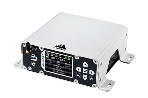
Hexagon | NovAtel is offering a new marine-certified GNSS receiver specially designed for nearshore applications. The MarinePak7 multi-constellation, multi-frequency receiver has been specifically engineered to receive Oceanix Correction Service from NovAtel, providing horizontal accuracy up to three centimeters (95%) in a marine environment.
With SPAN GNSS+INS technology capabilities, the MarinePak7 deeply couples GNSS and inertial measurement units (IMUs) for a 3D understanding of your position.
Delivering exceptional positioning, heading, attitude, velocity and heave measurements, the MarinePak7 is optimized to succeed in the demanding marine environment for nearshore applications.
An intuitive user interface reduces training and setup time, making it an ideal solution for use in demanding marine applications, including dredging, hydrographic survey, marine construction and nearshore renewable energy operations.
“The MarinePak7 is NovAtel’s first receiver designed specifically for a marine environment. It provides accurate and reliable positioning for nearshore marine operations using our GNSS technology and Oceanix Correction Service,” explained Hexagon | NovAtel marine segment portfolio manager David Russell. “This receiver was developed by a team of experienced marine engineers and incorporated feedback from existing NovAtel users to deliver a high-quality, all-in-one positioning solution for the nearshore marine market.”
Several optional features are available with the MarinePak7, including GNSS heading, interference mitigation and a UHF radio used to receive RTK corrections.
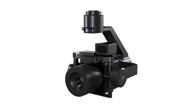
Phase One, a developer of digital imaging technologies, has announced the P3 Payload, a versatile solution designed for fast, efficient and safe inspection of critical infrastructure with an unmanned aerial vehicle (UAV).
The P3 Payload includes a Phase One iXM 100MP or 50MP camera, one of the RSM lens options, and a new gimbal with integrated rangefinder.
Available in the second quarter of 2021, the P3 Payload is offered in two configurations to meet a wide range of user requirements.
The P3 for the DJI M300 is plug-and-play, developed mainly for operators and service providers that already own, or are considering purchasing, a DJI M300.
The P3 MAVLink is ready for integration with drones based on the open-source MAVLink protocol, and suitable for bundling by OEMs and solution integrators.
“The P3 addresses the unmet need for a high-quality, integrated imaging solution for inspection of critical assets where capturing the details is of paramount importance,” said Michael Messerschmidt, portfolio director for drones and inspection. “The P3 Payload is designed specifically for aerial drone inspection of diverse infrastructure where every flight — and every shot — must count.”
The centerpiece of the payload is the customer’s choice of Phase One iXM 100MP or 50MP camera. Robust and waterproof, these sensors feature a dynamic range that guarantees sharp image collection in high-contrast or low-light environments. The variety of lens options ensures large surface areas can be captured with millimeter-level detail, even at safe distances from the asset. The new gimbal with the integrated laser rangefinder ensures precise and fast focusing on every shot, eliminating blurry and out-of-focus images.
The P3 Payload is suitable for these inspection applications:
High-value assets. Bridges, dams and energy facilities where the value of the structure itself is high and the demand for frequent, accurate and detailed data is critical.
High-risk assessment. Electric transmission lines, oil refineries and other complex sites where inherent danger requires high-resolution inspection from a distance that is safe for the structure, the drone and personnel.
Time-critical assets. Wind turbines, offshore oil rigs, and other facilities where inspection windows are limited, and every UAV flight must successfully capture the required information.
“We developed the P3 Payload for cost-effective, productive operation so that large surface areas can be covered in fewer images, significantly shortening the mission time,” Messerschmidt said. “More importantly, the P3 can be operated with minimal risk to the asset and ground crew.”
Tallysman Wireless is offering two new VeroStar marine antennas to its line of GNSS products. The VSP6037L-MAR supports the full GNSS spectrum and the VSP6337L-MAR supports GPS/QZSS-L1/L2/L5, GLONASS-G1/G2/G3, Galileo-E1/E5a/E5b, BeiDou-B1/B2/B2a, and NavIC-L5 signals. Both antennas support L-band correction signals.
Marine vessels often host both Iridium (1616–1626.5 MHz) and Inmarsat (uplink: 1626.5–1660.5 MHz) satellite communication antennas that transmit and receive signals. The VSP6037L-MAR and VSP6337L-MAR VeroStar marine antennas strongly attenuate interference from both signal sources, providing 75 dB to 85 dB of attenuation over Iridium and 85 dB to 95 dB over Inmarsat uplink, enabling clean GNSS signal reception and precise positioning.
Every VeroStar antenna features a robust pre-filter and a high-IP3 LNA architecture, minimizing de-sensing from high-level out-of-band signals, including 700 MHz LTE, while still providing a noise figure of only 1.8 dB.
VeroStar antennas provide the best-in-class low elevation angle tracking of the full GNSS spectrum and L-band correction signals. The wideband spherical antenna element enables VeroStar antennas to deliver ±2 mm phase centre variation (PCV), making them suitable for high-precision marine, positioning and machine control applications.
The VeroStar marine antennas are housed in a rugged and compact enclosure that supports 1-inch pipe thread or 5/8-inch-11 TPI mounting and provides a TNC antenna connector. The antennas have also obtained the stringent IEC 60945 and IEC 61108 marine certifications, making them suitable for challenging marine environments.
Microchip Technology has integrate its BlueSky technology signal-anomaly detection software into its SyncServer S600 Series network time server and instruments.
The SyncServer S600 Series now provides GPS jamming and spoofing detection and protection, in combination with local radio frequency (RF) data logging and analysis. The SyncServer S600 Series Stratum 1 instrument, along with the BlueSky technology’s intelligent jamming and spoofing detectors, continuously monitor local GPS constellation health and examine GPS and local RF signal integrity to assure validity.
If an anomaly is detected, the solution sends an alarm and, if necessary, the SyncServer instrument can be shifted to alternative time sources or an internal oscillator. This protects ongoing timing outputs while ensuring only minimal, predictable timing degradation to vital network and business operations in applications ranging from banking and stock trading to electric utilities and aerospace and defense.
The SyncServer BlueSky technology, which provides continuous detection and protection against GPS jamming and spoofing. includes a comprehensive suite of logging, charting and measuring tools to characterize local GPS satellite signals as well as local RF events over time.
This can help enable correlating, troubleshooting, identifying and correcting local anomalies, some of which may be related to consumer electronics, or nearby RF signal broadcasts. The solution is optionally available through the SyncServer v4.1 software release that provides a selection of features found in Microchip’s BlueSky GNSS Firewall solution for third-party GPS receivers and critical infrastructure.
In separate letters to members of the House of Representatives and the Senate, seven companies and a non-profit urged Congress to support alternative positioning, navigation and timing systems (PNT) with the “necessary funds and other appropriate policy tools.”
The letters focus on and endorse the system-of-systems approach outlined in the Department of Transportation’s (DOT) recent report to Congress on the results of its GPS Backup Technology Demonstration. The report found an adequate and robust American PNT system should include space-based L-band signals, low-frequency (LF) and ultra-high-frequency (UHS) signals, and fiber connections between the terrestrial LF and UHF transmitters.
“Our country depends on GPS for critical infrastructure, and there is an urgent need for resiliency being built into our critical infrastructure. Before the report came out, some of us had different ideas of how the U.S. should go forward,” said Ganesh Pattabiraman, CEO of NextNav. “But the DOT report provided the data to make it very clear that it is a combination of technologies that need to come together to truly enable nationwide backup to GPS, and it was good to see we could get industry alignment on the findings.”
The letters describe many of the threats to GPS, both natural and malicious; its vulnerabilities; and the dire consequences of disruptions. They go on to state that robust, more reliable PNT is needed for emerging and future systems like E911, 5G, resilient electrical grids, drones and other automated systems.
Monty Johnson, CEO of OPNT, a provider of time-over-fiber services, praised the findings of the DOT report. “The key to resilience and reliability in a system-of-systems is including technologies that deliver the same information using starkly different means. It is hard to imagine a combination of technologies that are more diverse than fiber, satellites, LF and UHF.”
According to Pattabiraman, the signers of the letter agree that the DOT report made clear that there are mature technologies available today that can address the GPS backup issue. DOT and Congress now have the data to act to enable a much-needed resilient infrastructure for the country.
Dana A. Goward, president of the non-profit RNT Foundation, agreed. He also observed that deciding on the technologies and congressional funding were important, but only first steps. “The goal of this effort is not to just implement systems,” he said. “it’s to make America safer. Establishing the services quickly and efficiently will be key, as will ensuring they are widely adopted.”
“Protecting the nation from the consequences of a space-based PNT disruption will require that these systems be accessed and used by a wide variety of users from first responders and delivery services, to all forms of critical infrastructure,” Goward said. “This means the government will need to eliminate as many barriers to adoption as possible. One or more of these alternatives has to be available to every American. And a basic level of service has to be free, just like the GPS utility it is reinforcing. Fortunately, we estimate this can be done relatively inexpensively. It will be only a small fraction of the $1.7B we spent on GPS last year.”
The alternative to making this relatively modest investment, according to Goward, is unacceptable.
“There are lots of threats to GPS,” he said. “Take the sun for example. The most recent study I saw estimates a 70% chance solar activity will damage the GPS constellation in the next 30 years and a 20% chance it will destroy a big part of it. And the sun is just one of the threats we face. We can’t keep playing this kind of Russian Roulette with the fate of our nation. Especially when other countries like Russia and China have already taken steps to protect themselves with terrestrial systems.”
A copy of the letter sent to Senators can be found here, and the one to members of the House of Representatives here.
A 2020 explosion in Lebanon’s port city of Beirut led to a southward-bound, high-velocity atmospheric wave that rivaled ones generated by volcanic eruptions.
The epicenter in Beirut, before and after the explosion.(Image: Bhaskar Kundu, et al. Scientific Reports. Feb. 2, 2021).
Just after 6 p.m. local time (15:00 UTC) on Aug. 4, 2020, more than 2,750 tons worth of unsafely stored ammonium nitrate exploded in Lebanon’s port city of Beirut, killing around 200 people, making more than 300,000 temporarily homeless, and leaving a 140-meter-diameter crater in its wake. The blast is considered one of the most powerful non-nuclear, man-made explosions in human history.
Now, calculations by Hokkaido University scientists in Japan have found that the atmospheric wave from the blast led to electron disturbances high in Earth’s upper atmosphere. They published their findings in the journal Scientific Reports.
The team of scientists, which included colleagues from the National Institute of Technology Rourkela in India, calculated changes in total electron content in Earth’s ionosphere: the part of the atmosphere from around 50 to 965 kilometres in altitude. Natural events like extreme ultraviolet radiation and geomagnetic storms, and man-made activities like nuclear tests, can cause disturbances to the ionosphere’s electron content.
“We found that the blast generated a wave that travelled in the ionosphere in a southwards direction at a velocity of around 0.8 kilometres per second,” says Hokkaido University Earth and Planetary scientist Kosuke Heki. This is similar to the speed of sound waves travelling through the ionosphere.
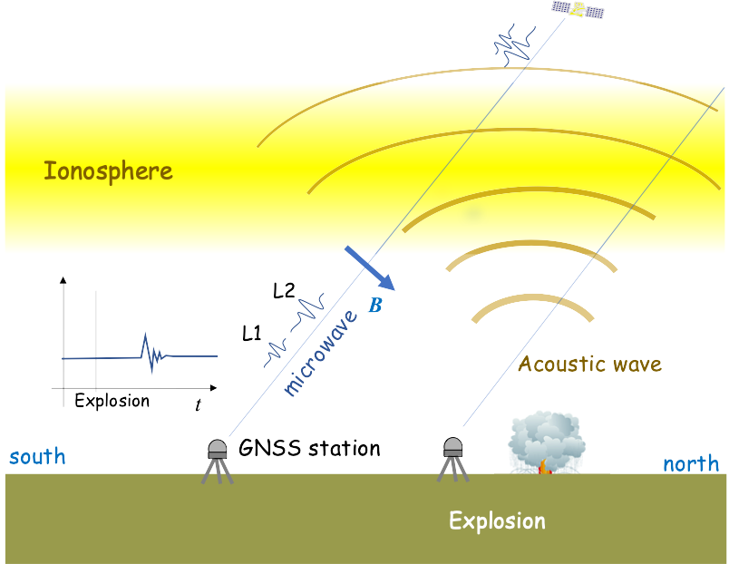
The team calculated changes in ionospheric electron content by looking at differences in delays experienced by microwave signals transmitted by GPS satellites to their ground stations. Changes in electron content affect these signals as they pass through the ionosphere and must be regularly taken into consideration to accurately measure GPS positions.
The ionospheric disturbance caused by an explosion can be detected by differential ionospheric delays of microwave signals of two carrier frequencies from global navigation satellite system (GNSS) satellites. (Image: Bhaskar Kundu, et al. Scientific Reports. Feb. 2, 2021).
The scientists also compared the magnitude of the ionospheric wave generated by the Beirut blast to similar waves following natural and anthropogenic events. They found that the wave generated by the Beirut blast was slightly larger than a wave generated by the 2004 eruption of Asama Volcano in central Japan, and comparable to ones that followed other recent eruptions on Japanese islands.
The energy of the ionospheric wave generated by the Beirut blast was significantly larger than a more energetic explosion in a Wyoming coal mine in the USA in 1996. The Beirut blast was equivalent to an explosion of 1.1 kilotons of TNT, while the Wyoming explosion was equivalent to 1.5 kilotons of TNT. The total electron content disturbance of the Wyoming explosion was only 1/10 of that caused by the Beirut blast. The scientists believe this was partially due to the Wyoming mine being located in a somewhat protected pit.
Free-to-use maps from more than 40 European countries will be made available through a new online gateway.
Open Maps for Europe will signpost and provide easy access to pan-European open data created using official map, geospatial and land information.
The project, which is co-financed by the Connecting Europe Facility of the European Union, is coordinated by EuroGeographics, the voice of European National Mapping, Cadastral and Land Registration Authorities, in partnership with the National Geographic Institute (NGI) Belgium.
Users will be able to access the data, created by the not-for-profit membership association, through an online interface developed by thinkWhere. The specialist in open source geographic information system (GIS) technologies will deliver the enhanced gateway for discovering, viewing, licensing and downloading the open datasets after winning an open tender.
The open data will include topographic data, a digital elevation model, imagery, a cadastral index map, and a regional gazetteer. The first maps are expected to be available in summer 2021.
“As the official national sources of map, cadastral and land information, our members’ data is fundamental to the everyday lives of people across Europe,”said Angela Baker, program manager, Data Access and Integration, EuroGeographics. “We may not always realise it, but their authoritative information underpins our public services, provides certainty of property ownership and helps to save precious time and potentially save lives when responding to emergencies. In an ever-connected world, it is also increasingly used in a wide range of applications relied upon by both citizens and businesses.”
“The Open Data Directive recognises that the value of data lies in its use and re-use. By providing easy access to free to use harmonised maps for Europe, our members want to boost the development of these innovative services. Their aim is to encourage greater use of their official geospatial data to drive market development and economic growth, and increase competitiveness by reducing costs.
“By working to ensure their data is interoperable, readily available and easily accessible, they are demonstrating a commitment to delivering Open Maps for Europe both now and in the future.”
Alan Moore, Chief Executive, thinkWhere added: “We are delighted to be working with EuroGeographics and its members on the Open Maps for Europe project where the primary aim is to drive up the use of official geospatial and open data.”
“Our mission is to make geographic data highly accessible, easy to use and an essential part of your information architecture. Collaborating with EuroGeographics and its members we will harness the power of our cloud-based geospatial data infrastructure and drive the development of a user-centric portal that makes it easy to find, view, publish and share the rich suite of pan European digital mapping, cadastral and topographic datasets.”
Open Maps for Europe runs until Dec. 31, 2022.
EuroGeographics is an international not-for-profit organization and the membership association for the European National Mapping, Cadastral and Land Registry Authorities. It brings together members from 46 countries, covering the whole of geographical Europe.
A train arrives at Tel Aviv University Station on the Israeli Railway in Tel Aviv. (Photo: svarshik/iStock Editorial/Getty Images Plus/Getty Images)
InfiniDome Ltd., a GPS security company, is joining with with Israeli partner Focus Telecom, in a new country-wide project with Israel Railways. The project involves deployment by Focus Telecom of GPS repeaters at more than 30 railway stations across Israel, providing accurate, location-based service indoors at all locations for a new Israel Railways ticketing app.
A critical component of the project is a monitoring service that detects and provides alerts of any GPS disruption or interference in real time, as they are identified. This is facilitated by infiniDome’s IoT GPSensors and its cloud-based GPS monitoring service, infiniCloud.
“Incorporating infiniDome’s proven resilient PNT capability to monitor and protect such a critical GPS service is a necessary enhancement for government designated critical infrastructures,” said Ehud Sharar, Focus Telecom CEO.
Photo: Focus Telecom
InfiniDome’s monitoring technology for critical assets detects and alerts operators of threats and disruptions of the essential GPS signals. These threats can originate from both malicious or natural causes.
“GPSensor IoT technology combined with our infiniCloud GPS security cloud assures real-time alerts about jamming attacks. All GPS signal data and its assured integrity are available as real time data so Israel Railways can react immediately and reduce downtime of the network,” said Omer Sharar, infiniDome CEO.
Israel Railways is the cornerstone of Israeli critical infrastructure. In 2018, Israel National Railway carried 68 million passengers. This same infiniDome GPS monitoring and protection technology is now available to defend critical infrastructure assets worldwide.
The JNC, sponsored by the Military Division of the Institute of Navigation, will be held Aug. 24-26 (FEDCON U.S. ONLY) at the Northern Kentucky Convention Center in Covington, Kentucky (Greater Cincinnati, Ohio).
The Classified Sessions (Secret U.S. ONLY) will be held Aug. 27, at the Air Force Institute of Technology on Wright-Patterson Air Force Base, Ohio. Visit requests and approvals are required for all session attendees.
View the JNC 2021 program and register at ion.org/jnc.
JNC 2021 is the largest U.S. military positioning, navigation and timing (PNT) conference of the year, with joint service and government participation.
Four new panel sessions have been introduced to this year’s technical program, which will host leaders and decision makers as they discuss and debate
MGUE Integration
Rapid Agile Development and Manufacturing
the National Critical Infrastructure Threat
Combatant Command Joint Urgent Operation Need (Secret, U.S. Only).
The technical program will focus on enhancing dominance and resilience for warfighting and homeland security PNT, and will include keynote addresses from:
William B. Nelson, director, Assured Positioning Navigation &Timing (APNT) Cross Functional Team (CFT), U.S. Army Futures Command
Ray Chartier, Jr., Safety of Navigation Mission manager, National Geospatial Intelligence Agency
General David D. Thompson, vice xhief of Space Operations, United States Space Force
Bradford Parkinson, Stanford Center for PNT
Attendance Restricted for JNC Technical Sessions
Conference attendance for both FEDCON (U.S. ONLY) (Aug. 24-26) and Classified Sessions (U.S. ONLY) (Aug. 27) will be screened by the Joint Navigation Warfare Center. Visit requests and approvals are required for all technical participants.
The exhibit hall is open to any registered conference attendee or exhibiting company representative, and all materials shall be designated DISTRO A/Publicly Releasable After Review.
Government-issued photo ID will be required to access all conference events.
If you have questions, contact the Institute of Navigation at [email protected] or by calling +1-703-366-2723.
First commercial deployment to be installed on a major turnpike used by tens of millions of vehicles every year
An electronic tolling system that uses high-performance lidar sensors from Cepton and a vehicle identification solution from Red Fox ID is expected to be deployed on a major highway turnpike crossing multiple states in the United States.
The turnpike project is expected to provide fast, accurate, real-time tolling to enable smooth traffic flows. Specifics of the project — including states involved and the timeframe of installation — were not disclosed.
Photo: Cepton
Based on an extended collaboration with leading lidar solution provider Cepton, Red Fox ID — a designer and developer of vehicle identification and classification solutions — has developed a multi-lane, free-flow tolling system called Quantum, which is able to accurately detect, track and classify vehicles of any size or type at highway speeds.
Quantum uses Cepton’s Micro Motion Technology (MMT)-based Sora-P60 or Sora-P90 lidar sensors for high-resolution vehicle profiling, to enable integrators and road operators to achieve highly accurate customer billing in real time, with free flow, barrier-free tolling.
For tolls to be charged correctly based on vehicle class, traditional tolling systems often use tollbooths for manual processing or depend on vehicle speed-reduction infrastructure to allow for time to capture vehicle information. That can cause congestion, increased emissions and frustration among customers.
Advanced systems that aim to enable faster tolling are often subject to significant errors, such as missed vehicles or wrong vehicle classification, because of limitations of the sensors being used, such as cameras and weight-based ground sensors. Vehicle-classification errors can have significant operating cost consequences for tolling operators, while leakage leads to lower revenues. With tollways processing tens of millions of vehicles a year, the cumulative impact of inaccuracies and errors creates significant administrative costs, losses and customer dissatisfaction.
Red Fox ID’s Quantum solution adds an extra layer of accuracy to the tolling system by integrating Cepton’s lidar technology. A gantry-mounted system using Quantum is able to accurately detect and track vehicles even as they switch lanes. Quantum captures and extracts high-quality information, such as vehicle velocity, size and class. All of that information is used as input to a separate billing system to compute and apply the appropriate tolling charge.
Quantum can also direct camera-based systems on the gantry to capture a vehicle’s front and rear plates in the event that a transponder cannot be detected. Through these innovations, Quantum has demonstrated a vehicle-detection accuracy in all traffic conditions of 99.96%, an axle-classification accuracy in all traffic conditions of 99.9% and a vehicle-length accuracy of +/-5%. The system uses Cepton’s Sora-P sensor family which has been tested and proven during extended trials, including in various weather and light conditions.
The recently released Sora-P90 lidar features a 380-Hz frame rate to deliver 1140 line scans per second, providing high-fidelity profiling of vehicles passing at highway speeds. Powered by Cepton’s patented, rotation-free, frictionless and mirrorless MMT, the Sora-P90 is rugged, reliable and scalable, making it suited for automated tolling applications.With a 90° horizontal field of view, the lidar can be set up using one gantry instead of two separate sensors and gantries, making overall deployment more cost effective.
Red Fox ID has been working with Cepton on multiple trials and proof of concept projects across the globe since 2019. This has allowed both partners to expand the application of advanced lidar intelligence for high-accuracy tolling on highways and roadways in a growing list of countries, across North America, Europe, the Middle Eas, Africa and Asia.
“Our industry’s drive for overhead tolling solutions has failed to materialize in the mainstream due, primarily, to a lack of sensors capable of achieving the high levels of accuracy required for a modern tolling product,” said Steve Bird, CEO of Red Fox ID. “The technical innovations enabled by Cepton offer us new design options. Improvements in the resolution of the data, the ability to deal with the full range of weather-related conditions, and the development of a sensor with an in-service lifespan suitable for tolling make it possible, for the first time, for us to develop an accurate, overhead free flow system. Our partnership with Cepton will be a game-changer in revolutionizing the tolling market.”
“It is very clear that lidar’s uses extend far beyond just serving as the ‘eyes’ of autonomous vehicles,” said Jun Pei, CEO of Cepton. “Our lidar technology has a huge part to play in making our transport infrastructure smarter, safer, greener and more efficient, as we can see here following Quantum’s highly successful real-world testing. The key to success for toll operators and providers is minimal error and maximum yield, and we are excited to be partnering with Red Fox ID to help our mutual customers achieve this goal with our market-leading lidar technology. We look forward to working with them to expand our partnership worldwide.”
Release follows $1 billion Innovyze acquisition announcement by Autodesk
Water infrastructure software company Innovyze has released Info360.com, a cloud-based, artificial intelligence-powered platform for real-world water lifecycle management.
Combined with Info360 Insight, a data visualization and workflow solution, the platform enables dynamic digital twins for the water industry.
Dynamic Digital Twins are virtual models of real-world assets and systems that can learn and adapt to changing circumstances. Built upon Amazon Web Services (AWS), Info360.com is uniquely designed to support Dynamic Digital Twins by gathering and unifying asset information, connecting live and historic performance data to Innovyze as well as third-party applications.
Autodesk Inc. announced March 1 it signed a definitive agreement to acquire Portland, Oregon-based Innovyze for $1 billion net of cash subject to working capital and tax closing adjustments. Autodesk’s digital-twin strategy creates a clearer path to a more sustainable and digitized water industry, the company said.
This context-aware platform can predict future performance using synchronized computational models that become more intelligent as they’re used. Info360.com provides recommended best-case actions that can help water utilities maintain the highest levels of service, capacity and efficiency.
Due to water system complexity and static operating budgets, many water utilities have struggled to adopt the digital transformation technologies that would allow them to improve predictability and performance. Using the power of the cloud, Info360.com is financially and operationally more accessible, powerful and flexible than traditional on-premise systems.
“The complex, physical properties of water and massive, underground infrastructure that must be monitored and managed make digitization extremely challenging for water utilities,” said Colby Manwaring, Chief Executive Officer at Innovyze. “We’ve combined 35 years of expertise in water management with the power of the cloud to bridge the data and technology gaps that have kept water utilities from truly capitalizing on Digital Twins with our new Info360.com platform. This is a game-changer in making digital transformation achievable for water utilities of any size.”
The new Info360 Insight SaaS application provides utilities with customizable dashboards and KPIs that track and visualize the real-time performance of the entire water distribution system. Performance data can be used and analyzed for daily operations, such as pipe break detection and water loss. The same data can also be used to plan for future maintenance and capacity fluctuations, with seamless integration into the hydraulic model.
“Info360 Insight is the first of several SaaS applications we’re delivering for the Info360.com platform, all offering advantages to utilities like easy onboarding, infinite scalability, and rigorous security out of the box,” said Rick Gruenhagen, CTO at Innovyze. “Better yet, the Info360 platform architecture incorporates cutting-edge technologies like predictive analytics and artificial intelligence tuned specifically for the water lifecycle, allowing utilities of all sizes to stay at the forefront of innovation without the need to maintain complex software or hire hordes of IT experts. As a result, utilities will have the technology foundation they need to deliver the highest possible service at the lowest possible cost.”
Info360 Insight provides real-time ingestion and analysis of SCADA data, along with 24/7 event monitoring, enabling utilities to detect incidents within their infrastructure. The system can check multiple resolution scenarios and apply recommended actions to resolve the failure as quickly as possible — ensuring a higher level of service and reliability.
In the latest edition of this classroom textbook, Getting to Know ArcGIS Desktop 10.8 guides students and professionals through the fundamentals of making maps and analyzing data using the latest Esri ArcGIS Desktop software.
The comprehensive, hands-on tutorial, moves readers from basic GIS concepts to sophisticated GIS analysis. Readers gain practical knowledge about ArcGIS Desktop tools and functionality. Exercises address querying map data, making map layouts, symbolizing and labeling maps, setting map projections, creating and sharing web maps, building and editing geodatabases, and analyzing geospatial data.
Data for completing the exercises and a 180-day free trial of ArcGIS are also available for download.