uAvionix has announced pingRX Pro, a detect-and-avoid ADS-B receiver for professional unmanned aircraft systems (UAS). PingRX Pro is expected to be available in the fourth quarter of this year.
pingRX Pro detects private and commercial aircraft operating on 978 MHz and 1090 MHz. The received aircraft’s identity, position and altitude are visualized on a moving map in real time, allowing the UAS operator or autopilot to remain well clear.
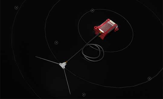
The new pingRX Pro continues uAvionix’s lineage of easy to integrate receivers with direct support for popular Ardupilot-based autopilot systems. By adding the protection of an aircraft-grade aluminum case and detachable remote mount antenna, pingRX Pro provides an ADS-B receiver for professional UAS operators who need performance, quality and flexibility for limitless UAS applications.
“UAvionix has led the way in ADS-B solutions for unmanned aircraft since our founding.” said Christian Ramsey, president of uAvionix. “Industry leaders and BVLOS operators continually choose ADS-B receivers as their primary detect-and-avoid solution. pingRX Pro now offers manufacturers and integrators the installation flexibility they need for their enterprise aircraft. ”
Weighing less than 8 grams, pingRX Pro features uAvionix ping ADS-B, proven in over a half-million ADS-B solutions worldwide, from UAS to airport vehicles to certified general aviation solutions.
PingRX Pro offers an external antenna, allowing operators to install it anywhere on the airframe. UAS are often designed from materials that can block radio frequencies and impair radio performance. By providing an external remote mounted antenna, performance can be maximized while providing critical protection of the receiver mounted inside the fuselage.
ADS-B Out
Diagram: uAvionix
ADS-B uses precision GPS information to broadcast the position of an aircraft in real time. The technology allows aircraft to share the skies more efficiently by telling each other where they are.
With ADS-B already widely adopted by manned aircraft, the task of detect and avoid is eased because the manned aircraft are broadcasting their position directly to the drone operator with no intermediary. While many aircraft not yet equipped with ADS-B OUT, nearly all large commercial operators are equipped.
The United States requires ADS-B OUT on all manned aircraft with an engine-driven electrical system operating near medium and large cities from the surface to 4,000 feet above ground.
Given the likelihood of ADS-B OUT on manned aircraft, and the density in these prime areas for inspection and package delivery, pingRX Pro ADS-B IN enables drone operators to meet their requirement to remain well clear of surrounding aircraft.
PingRX Pro tracks 100 simultaneous aircraft at ranges exceeding 150 miles, all at nearly 200% less power consumption of the alternatives.
In previous years, the Civil GPS Service Interface Committee (CGSIC) took place right before the start of the ION GNSS+ conference.
This year, the U.S. Department of Transportation (DOT) and the Coast Guard Navigation Center (NAVCEN) are holding the 60th meeting virtually, in collaboration with the Institute of Navigation (ION).
The meeting will take place Sept. 21-22 online before the annual ION GNSS+ conference, which will also take place virtually because of the COVID-19 pandemic.
All CGSIC meetings are free and open to the public. Anyone in the world with access to a computer can attend these public meetings of the U.S. Civil GPS Program.
DOT serves as the civil lead for the GPS program and chairs the CGSIC in this capacity. NAVCEN is assigned duties as deputy chair and executive secretariat for the CGSIC.
Subcommittees of the CGSIC for Timing, International Information, and Surveying-Mapping-Geosciences will hold meetings Sept. 21, and a summary of these meetings will be presented to the CGSIC plenary session on Sept. 22.
The keynote speaker for this year’s plenary session will be Major General John E. Shaw, Combined Force Space Component Commander, U.S. Space Command, and Commander, Space Operations Command, U.S. Space Force.
Presentations this year include:
PNT updates from various countries around the world
Atomic clocks for fundamental physics: time for discovery
Missouri Department of Agriculture land survey program
National PNT Policy Update from the National Space Council
Mobile geospatial technology’s role in tracking beetle infestation in our nation’s forests
The full agenda is available online. CGSIC presentations will be posted online shortly after the meeting ends. Register for the meetings here.
The White House Office of Science and Technology Policy is asking for ideas on what technology to research to protect GPS. The research and development dollars are earmarked for projects that minimize or eliminate disruption to critical infrastructure from intentional and unintentional interference.
The office is seeking input “from all interested parties on the development of a National Research and Development Plan for Positioning, Navigation, and Timing (PNT) Resilience.
“The plan will focus on the research and development (R&D) and pilot testing needed to develop additional PNT systems and services that are resilient to interference and manipulation and that are not dependent upon global navigation satellite systems (GNSS).
“The plan will also include approaches to integrate and use multiple PNT services for enhancing resilience,” the RFI states.
The effort is specifically headed by the Subcommittee on Resilience Science and Technology (SRST.) “The input received on these topics will assist the subcommittee in developing recommendations for prioritization of R&D activities,” the RFI states.
Deadline for comments is 11:59 pm ET on Sept. 9.
Responses should be submitted via email to [email protected] — include “RFI Response: PNT Resilience” in the subject line of the message.
The United Arab Emirates (UAE) will launch the first of two navigation satellites in 2021, according to the Emirates News Agency (WAM), spurred by the successful launch of a Mars probe on July 19.
The satellite is designed to demonstrate the country’s technological capabilities. A second, further enhanced satellite will be launched in 2022, said Khaled Al Hashmi, director of the National Space Science and Technology Center (NSSTC) at UAE University, Al Ain.
The satellites are the first project of Satellite Assembly, Integration and Testing Center, a collaboration formed by Tawazun Economic Council with Airbus and the NSSTC.
Funded by the UAE Space Agency, the satellites are not intended to add a navigation system — at least not right away. “We try to select a certain technology, design and develop the satellite and payload here, and will own the intellectual property rights,” Hashmi told WAM, the state news agency.
The UAE’s navigation satellite project is part of the Science and Technology Roadmap created by the UAE Space Agency and the NSSTC on developing new technologies. The NSSTC was jointly established by UAE University, UAE Space Agency and the Telecommunications Regulatory Authority (ICT-Fund).
Decision on the program came following the successful launch of the Hope Probe, which opened collaboration opportunities between the UAE and global space agencies and companies. In the first Arab interplanetary mission, the probe will reach Mars in 2021 to provide a complete picture of the planet’s atmosphere.
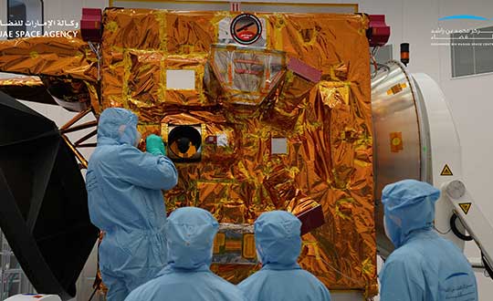
Engineers and technicians at the Mohammed bin Rashid Space Center prepare the Hope Probe for its trip to Mars. (Photo: UAE Space Agency)
ComNav Technology released several OEM boards at Intergeo 2019, which took place in Stuttgart, Germany. Arthur Wang, international technical sales engineer at ComNav, discusses the new products, including the K727, K703 and K705.
Carlson Software is now offering its next-generation multi-frequency, multi-GNSS BRx7 smart antenna.
The BRx7 is a full redesign of Carlson’s flagship GNSS receiver, delivering high-level specifications, performance and value for surveyors, contractors, engineers and GIS professionals.
Weighing 2.8 pounds with batteries, the BRx7 saves time and increases productivity by accurately compensating for tilt. It comes standard with dual, hot-swappable batteries for 11+ hours of uninterrupted efficiency. The BRx7 provides 800+ channels, 8gb of memory, and is designed with a rugged, compact IP67-rated housing.
Best-in-class RTK performance is provided by the Athena GNSS engine, supporting multi-frequency GPS, GLONASS, BeiDou, Galileo, QZSS, IRNSS and Atlas L-band capability. In addition, the BRx7 uses proprietary SureFix technology to provide a high-fidelity quality indicator of the RTK solution, allowing users an extremely high confidence in their current accuracy.
The BRx7 provides RTK baselines up to 50 km with fast acquisition times when used with Carlson Listen-Listen, as well as UHF, spread spectrum, cellular, Bluetooth and Wi-Fi wireless communication.
Well-suited to a variety of operating modes, the BRx7 can be deployed as a powerful base with additional access to BeiDou phase 3 satellites in a base-rover setup, or as a lightweight, powerful network rover.
“The BRx7 represents the next generation of GNSS technology,” said Butch Herter, Carlson’s director of hardware development. “Through this total redesign in partnership with our manufacturer, Hemisphere GNSS, we’ve brought the technology and functionality above the competition while retaining the ease-of-use, durability, and superior support that Carlson is known for.”
The smart antenna comes with a dual-band radio module that is capable of both 400 MHz and 900 MHz operation. This allows for the long range capability of the UHF 400 MHz signal plus the ability to switch to the 900 MHz frequency-hopping spread spectrum (FHSS) signal for better performance in noisy radio environments.
The BRx7 introduces a new INS-based sensor-fusion platform to support enhanced tilted pole measurements for land survey applications. This new design allows for easy calibration, is immune to magnetic interference, and is extremely reliable in virtually any environment.
“The BRx7 represents the advanced technology, durability, and ease-of-use that our customers have come to expect,” said Bruce Carlson, founder and president of Carlson Software. “By redesigning this system from the ground up, we are offering our customers both unparalleled performance and versatility, but also a value that’s unbeatable in the market today.”
Tallysman Wireless Inc. has added four embedded VeroStar products to its line of GNSS antennas. The compact and light embedded VeroStar models offer key features not available in many other embedded antennas on the market.
Photo: Tallysman
The VSE6028, VSE6028L, VSE6328 and VSE6328L embedded VeroStar antennas are designed and crafted for high-accuracy positioning. With an exceptionally low roll-off from zenith to the horizon, VeroStar antennas provide tracking of GNSS and L-band correction signals at low elevation angles.
The optimized axial ratio at all elevation angles results in excellent multipath rejection, enabling accurate and precise code and phase tracking.
For details on the antenna and its development, see “Innovation” in the September issue.
VeroStar antennas feature a robust pre-filter and high-IP3 LNA architecture, minimizing de-sensing from high-level out-of-band signals, including 700 MHz LTE, while still providing a noise figure of only 1.8 dB.
Photo: Tallysman
The light (80 g) and compact (106 mm in diameter and 40 mm in height) wide-band spherical antenna element enables the VeroStar to deliver a ±2 mm phase centre variation (PCV), making it ideal for high-precision applications, such as autonomous vehicle navigation (land, sea and air), smart survey devices, and maritime positioning.
The VSE6028 supports the full GNSS spectrum (the VSE6028L includes support for L-band correction services), while the VSE6328 supports the GPS/QZSS-L1/L2/L5, GLONASS-G1/G2/G3, Galileo-E1/E5a/E5b, BeiDou-B1/B2/B2a, and NavIC-L5 signals and frequency bands (the VSE6328L includes support for L-band correction services).
The unique features of the VeroStar antennas deliver high signal-to-noise ratio (SNR), high accuracy, and high precision in challenging environments.
Tactical Embedded series of GNSS/IMUs. (Photo: VectorNav)
Embedded navigation company VectorNav Technologies has introduced a new line of inertial products: the VectorNav Tactical Embedded series of GNSS/IMUs.
Featuring a tactical-grade inertial measurement unit (IMU) and a multi-band GNSS receivers, the Tactical Embedded delivers milliradian attitude accuracy and centimeter-level positioning capability in a miniature 15-gram package.
VectorNav’s Tactical Embedded line is in a new smaller size, and enables cost reductions for a wide range of autonomous pointing and geo-referencing applications. These include gimballed intelligence, surveillance and reconnaissance (ISR), SATCOM systems, lidar mapping and photogrammetry, among many others.
The Tactical Embedded line supports external SAASM GPS for defense applications in ISR, electronic warfare, munitions and UAV navigation.
“The Tactical Embedded is the culmination of years of development to bring milliradian-level attitude performance and robust positioning into a form factor that represents a disruptive step in inertial navigation capability,” said VectorNav President John Brashear. “Systems integrators worldwide can now embed tactical-grade inertial navigation capabilities into their electronics, unlocking a range of new applications and possibilities.”
Designed and engineered at VectorNav’s AS9100-certified facility in Dallas, Texas, the Tactical Embedded line includes the VN-110E IMU/AHRS, the VN-210E GNSS-aided inertial navigation system (INS), and the VN-310E Dual Antenna GNSS/INS.
Highlights include:
0.05-0.1° heading; 0.015° pitch and roll
1 m horizontal and 1.5 m vertical position accuracy
Recent completion of China’s BeiDou satellite navigation system has rekindled privacy and security concerns among some in the West. China has incorporated a two-way messaging capability into BeiDou that many fear will be used to track individuals and install malware on user devices.
Most satellite navigation experts view such concerns as far overblown.
At the same time, though little discussed, BeiDou’s completion does signal a new phase for China’s status as a world power and its ability to challenge the West on many fronts.
Two-way communications
It is possible for specially equipped receivers to communicate back to the BeiDou constellation. But this is not true for the vast majority of receivers (including those in cell phones). Industry experts say that all mass market chips for every GNSS system, including BeiDou, are “receive only.” Only specially equipped devices will be able to take advantage of its two-way communications capability, and it should be quite apparent to users when it is in operation.
Users, they say, should be much more concerned about location privacy and security issues that have been around for decades. Mobile phones have long reported user locations through the cellular network based upon information derived from GPS, WiFi ranging and other position calculations. The ability to hack and compromise a cell phone or other receiver will not be affected by the addition of BeiDou as a receive-only location source.
It is also important to note that using specialized equipment for two-way communication with a Global Satellite Navigation System (GNSS) is not something new to BeiDou. While the Chinese system may have improved upon the capability, users with the right equipment can send messages using the Search and Rescue functions to the United States’ GPS, Europe’s Galileo, and Russia’s GLONASS.
China has risen
Completion of BeiDou, unquestionably a significant technical achievement, does signal a significant step up for Chin’s status as a world power and influencer. It is a declaration of technical independence from the West with wide ranging geo-political impacts.
“(1) address national security requirements by ending military reliance on GPS;
(2) build a commercial downstream satellite navigation industry to take advantage of the quickly expanding market; and
(3) achieve domestic and international prestige by fielding one of only four such global navigation satellite systems (GNSS) yet developed”
Military Power and National Security. The Chinese military has long sought its own GNSS. This was amplified during a crisis in 1996 when it fired three missiles toward Taiwan as a warning. One struck the sea about 11 miles from a Taiwanese military base, but the other two disappeared. China claims that the United States interfered with GPS signals and was to blame. The Chinese military was both horrified and humiliated.
Having a sovereign GNSS eliminates the problem of relying on the U.S., Russia, or Europe for satellite navigation. That it is the world’s newest system also certainly has its advantages. China has undoubtedly incorporated state of the art anti-jamming and anti-spoofing capabilities into the version of BeiDou used by the military. After decades of observing others interfering with GNSS signals, and doing a fair bit of it on their own, it would be hard to imagine Chinese engineers not including the latest resilience features.
An operational BeiDou also means that China’s military is much freer to interfere with GPS and other GNSS in pursuit of tactical and strategic advantage without endangering its own services and infrastructure. It is likely that the levels of jamming and spoofing seen near the Spratley Islands and mainland ports will increase. Even if they do not, the increased possibility of Chinese interference will add yet another degree of complexity and uncertainty for western military forces.
Economic Power. The technological and commercial benefits of BeiDou for China are unquestionably substantial as well. Direct benefit from the manufacture and sale of equipment, plus spinoff industries and technologies, add to an already impressive national technology and economic portfolio. This is especially true since positioning, navigation, and timing (PNT) services are a “silent utility” underpinning so many network and other technological systems. The huge domestic market and robust overseas sales continue to grow (by 20% per annum according to Chinese reports) providing huge returns.
Prestige and Soft Power. “BeiDou launch marks China’s rise to ‘major space power’” read a recent headline in the Asia Times. This is perhaps understated as, with BeiDou complete, there is, technologically, little the West has achieved that China has not equaled. This has greatly enhanced China’s global standing and made it, in the eyes of many in the developing world, an ally and provider as good or better than the U.S. or Europe.
And China is eager to share its new PNT utility with others to further, not just its economy, but more importantly its long-term strategic interests.
Forsaking GPS
Regionally, China has been encouraging neighbors to adopt BeiDou for national PNT and forsake GPS. As one example it provided Thailand with nearly $300M in foreign aid targeted to promoting BeiDou use by Thai government organizations.
Writing in July in The Diplomat, Dr. Namrata Goswami observed
“… BeiDou is located within China’s ‘Information Silk Road,’ a subset of its land and maritime silk routes under the Belt and Road Initiative (BRI). China is now able to extend influence in a multidomain environment (land, sea and space) via its BeiDou space system, which provides navigation to aircraft, submarines, missiles, as well as commercial services dependent on such navigation. China’s Ministry of Industry and Information Technology sells the Information Silk Road, to include BeiDou and 5G networks, to global audiences as a completely self-sufficient technology infrastructure that anticipates life in the 21st century.”
This extends China’s influence through BeiDou even farther and has led a number of nations to seek closer ties with China through BeiDou.
Mohamed Ben Amor, secretary general of the Tunisia-based Arab Information and Communication Technology Organization, an organization of the Arab League, told GPSDaily.com, “Cooperation on the BDS is of special significance for the Belt and Road construction…The next step of the China-Arab cooperation is to achieve further connectivity and both sides can apply the BDS to promote regional technological and economic development.”
Iran’s view
Iran has had a Memorandum of Understanding with China about BeiDou since 2015. It provides for BeiDou ground stations in Iran, access for Iran to high-precision services, and establishment of an Iranian center for space data collection.
And In a tweet last week Iran’s Ambassador to China cited BeiDou’s completion as the “…end to the monopoly of the U.S.’s GPS.” He said, “There is great potential for aerospace cooperation with China,” and went on to suggest that Iranian aerospace students could work as a bridge between the two countries.
Similar comments have been published from entities in India, Indonesia, Malaysia, and throughout Southeast Asia.
China is indeed to be congratulated for a significant achievement with the completion of BeiDou. Even more noteworthy, though, is how it has integrated BeiDou seamlessly into its national plans for technology, economic, military and diplomatic efforts — a comprehensive, coordinated program to boost its standing in the world, especially relative to the United States and Europe.
Dana Goward is president of the Resilient Navigation and Timing Foundation. He is the proprietor at Maritime Governance LLC. In August 2013, he retired from the federal Senior Executive Service, having served as the maritime navigation authority for the United States. As director of Marine Transportation Systems for the U.S. Coast Guard, he led 12 different navigation-related business lines budgeted at more than $1.3 billion per year. He has represented the U.S. at IMO, IALA, the UN anti-piracy working group and other international forums. A licensed helicopter and fixed-wing pilot, he has also served as a navigator at sea and is a retired Coast Guard Captain.
The United States Space Force (USSF) and the Space and the Missile Systems Center achieved another major GPS milestone on July 27 when the GPS III Space Vehicle (SV) 03 received USSF’s Operational Acceptance approval.
This marks the third GPS III satellite to receive operational acceptance in less than a year.
GPS III SV-03 satellite packed prior to shipment to Cape Canaveral. (Photo: Lockheed Martin)
The GPS III satellites are the newest generation built by Lockheed Martin that provide precise positioning, navigation and timing information with three times better accuracy, and up to eight times improved anti-jamming capability than previous generations of GPS satellites.
SV03 was launched on June 30 and was the second National Security Space Launch (NSSL) mission launched on a SpaceX Falcon 9 rocket. This was the first NSSL mission where a Launch Service Provider recovered a booster, with SpaceX successfully recovering the first stage and fairings as part of the launch.
The GPS III SV03 mission was dedicated to Colonel Thomas G. Falzarano, 21st Space Wing commander, who passed away in May.
“We are adding GPS warfighter capability and resiliency with each new GPS III satellite. The on-boarding of GPS III SV03 enables our first use of cross link commanding capability for assured nuclear detection,” said Lt. Col. Michael Schriever, 2nd Space Operations Squadron commander. “With the GPS III SV03 addition to the constellation, our modernized signals capable satellites increases to 22 vehicles. This results in nearly a fully capable Military-Code constellation, which our space warfighters will operate to deliver expanded capabilities to the joint force.”
The USSF’s Space and Missile Systems Center, located at Los Angeles Air Force Base, California, is the center of excellence for developing, acquiring and delivering military space systems. Its portfolio includes
GPS, military satellite communications, defense meteorological satellites, space launch and range systems, satellite control networks, space based infrared systems, and space situational awareness capabilities.
The Federal Aviation Administration (FAA) has awarded $3.3 million in research, education and training grants to universities that comprise the FAA’s Air Transportation Center of Excellence (COE) for Unmanned Aircraft Systems, also known as the Alliance for System Safety of UAS through Research Excellence (ASSURE).
“These grants will help develop a greater array of innovative strategies to more effectively deploy drones during emergency response situations,” said U.S. Transportation Secretary Elaine Chao.
The FAA’s CEO program, authorized by Congress, is a long-term, cost-sharing partnership between academia, industry and government. The program enables the FAA to work with center members and affiliates to conduct research in airspace and airport planning and design, environment and aviation safety, FAA said.
Mississippi State University received the Alliance for System Safety of UAS through ASSURE Program Management grant for $1,290,410. This grant is for the ASSURE lead university to provide overall program management. This program management will include tracking of financial information for all core university project activities; reviewing and vetting of all project related documentation prior to submission to the FAA; hosting and facilitating all FAA-required meetings; and outreach to government, industry and academia, FAA said.
Six universities, including the University of Alabama–Huntsville ($1,101,000), New Mexico State University ($234,000), the University of Alaska, Fairbanks ($245,000), Mississippi State University ($130,000), North Carolina State University ($124,979) and Oregon State University ($165,000) received grants for Disaster Preparedness and Response (Phase I and II, as directed by Congress). According to FAA, this research will provide insight into the safe integration of UAS into the disaster preparedness and response areas. This research will look at how UAS can aid in disaster preparedness and response to different natural and human-made disasters. It will focus on procedures to coordinate with the Department of Interior, the Department of Homeland Security, the Federal Emergency Management Agency and other federal, local and state organizations to ensure proper coordination during those emergencies.
There are currently 1.65 million recreational and commercial drones in the active UAS fleet. That number is expected to grow to as high as 2.31 million by 2024, FAA reported. The ASSURE grants are aimed at continuing the safe and successful integration of drones into the nation’s airspace.
“Collaboration is hugely important as we work to safely integrate UAS into the aerospace system,” said FAA Administrator Steve Dickson. “These important grants fund the research which allows us to learn and implement the safety measures associated with UAS operations in the airspace.”
The COE universities received a total of $3.3 million to advance specific goals and projects. This is the second round of ASSURE grants. The grants listed above will bring the fiscal year 2020 total for this COE to $5.8 million.
The global security, defense and aerospace company joins alliance dedicated to protecting, promoting and enhancing the use of GPS technology
The GPS Innovation Alliance (GPSIA) is welcoming BAE Systems Inc. as the newest member of the organization. BAE Systems, a global defense, security and aerospace company, joins member companies John Deere, Garmin, Trimble, Lockheed Martin and Collins Aerospace, a unit of Raytheon Technologies Corp., as well as 11 national organizations that make up GPSIA’s affiliates program.
As the newest member of the alliance and the third aerospace and defense corporation to join the organization in eight months, BAE Systems will work with GPSIA to support its goal of enhancing GPS innovation, creativity and entrepreneurship — while advocating as the voice of the GPS industry in Washington.
“We are excited to welcome BAE Systems as the newest member of the Alliance — a monumental addition that marks the doubling of our membership in the past eight months,” said GPSIA Executive Director J. David Grossman. “The continued growth of GPSIA demonstrates the criticality of protecting GPS and the substantial value our organization delivers through advocacy, information sharing, and technical standards. We remain committed to ensuring the economic and societal benefits of GPS are fully realized.”
BAE Systems is a global leader in designing and implementing high-end technology to extend the reach and significance of GPS in defense. BAE Systems’ radiation-hardened electronics have been on board satellites and spacecraft for almost 30 years and are currently providing the high-performance onboard processing capability for the GPS III satellite mission. Promoting space resiliency for over 30 years, BAE Systems is a cornerstone of the growing importance of GPS technologies on the space frontier.
BAE Systems has not only pioneered critical technologies suitable for GPS applications in space, but has also developed, manufactured, integrated and supported GPS receivers and guidance systems for advanced military applications on land, sea or air.
The company was instrumental in the development of NAVWAR sensor technology, intended to meet growing challenges associated with maintaining military positioning, navigation and timing (PNT) advantage using satellite navigation, and has engineered top-tier jammers and navigation systems for decades. Their work has been critical in securing the safety and technological supremacy of our nation’s defenses.
“GPS is an essential part of our world — from our infrastructure and economy to the security of our nation,” said Frank Ruggiero, senior vice president, government relations, BAE Systems. “As a leading provider of defense electronics and communications systems, we are excited to join the GPS Innovation Alliance to expand the development of cutting-edge GPS technologies.”