Grab Singapore has launched a pilot program that uses high-accuracy lane-level GPS positioning to enhance the navigation experience for its driver and delivery partners in Singapore.
The pilot — rolled out in collaboration with Oppo, Qualcomm Technologies and Swift Navigation — also marks the first deployment of high-accuracy GPS positioning on mobile phones and app integration in Southeast Asia, delivering unprecedented outdoor location accuracy for Grab’s partners.
Grab is a leading app in Southeast Asia, operating across the deliveries, mobility and digital financial services sectors. It enables location-based services in more than 800 cities in eight Southeast Asian countries: Cambodia, Indonesia, Malaysia, Myanmar, the Philippines, Singapore, Thailand and Vietnam.
As part of its ongoing efforts to enhance the GrabMaps navigation experience, Grab continually explores new technologies to help improve accuracy and reliability for its driver and delivery partners. In dense urban environments such as Singapore’s high-rise buildings, multi-level roads, and underground networks can degrade standard GPS accuracy above 20 m, complicating navigation between pick-ups and drop-offs, and reducing ETA accuracy.
By bringing together leading technology partners to create an advanced navigation system, Grab’s driver- and delivery-partners can now pinpoint their location with higher accuracy, improving navigation efficiency in GPS-challenging environments, while enabling smoother pick-ups and reduced cancellations.
The pilot taps on the individual expertise of the following partners:
OPPO, which provides its Find N5 foldable phone with dual-frequency GNSS capable of supporting the latest positioning technology.
Qualcomm Technologies, which activates the Meter-Level Positioning for Mobile featured in the Snapdragon 8 Elite Mobile Platform that powers the OPPO Find N5, enabling real-time GPS correction signals.
Swift Navigation, which provides its cloud-based Skylark Precise Positioning Service that uses advanced atmospheric modeling to correct GPS signal errors and deliver 10x greater positioning accuracy. Skylark is built on top of a network of ground reference stations operated in partnership with network operators around the world, including Singapore Land Authority (SLA). SLA operates the Singapore Satellite Positioning Reference Network (SiReNT) which provides Skylark with accurate GNSS data to enable precise positioning for last mile ride hailing and logistics in Singapore.
Together, these technologies power the pilot, with OPPO’s Find N5 foldable phone, Qualcomm Technologies’s Snapdragon 8 Elite Mobile Platform, and Swift Navigation’s Skylark working in concert to deliver precision navigation experiences.
With results of the pilot, Grab plans to extend the enhanced positioning capability to its proprietary Karta devices in the near future — broadening access to precise navigation technology and ensuring more driver and delivery partners can benefit from it over time.
The European Navigation Conference (ENC) series is widely acknowledged as the most important annual event in Europe bringing together the full positioning, navigation and timing (PNT) community.
ENC 2026 will take place in Vienna, Austria, from April 28-30, 2026. This follows very successful ENCs in the last few years.
ENC2026 offers:
a technical program across three days with up to four parallel sessions,
daily keynote addresses in plenary, bringing the community together,
a friendly and collaborative atmosphere, with opportunities to meet exhibitors and fellow delegates, including informally over drinks and dinner as part of the conference social programme,
an environment to gain insights, grow social networks and foster new collaborations.
The ENC-series is a collaboration across the European Group of Institutes of Navigation (EUGIN), with the Austrian Institute of Navigation (OVN) leading ENC 2026 at the Austria Center Vienna.
The conference will highlight the latest advancements in PNT. The broad technical program will include all related aspects of technology, science, systems and applications.
ENC-series is open to everyone from industry, academia, government and user segments. To learn more, visit the ENC 2026 website.
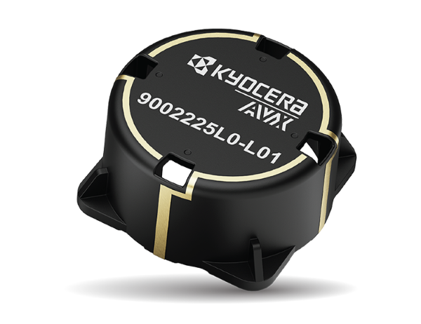
KYOCERA AVX has launched an LDS cap antenna and evaluation board optimized for Iridium satellite IoT applications and designated as Iridium Qualified Antenna products for Iridium Certus 9704 modules.
The antenna was developed to provide Iridium with an embedded antenna optimized for low-Earth-orbit (LEO) satellites used to provide seamless connectivity and data exchange for IoT devices anywhere in the world. The new LDS cap antenna developed for Iridium outperforms the ceramic patch antennas traditionally used in these applications.
Manufactured using laser direct structuring (LDS) technology — an efficient process for creating complex, compact, lightweight, wide-bandwidth, and high-gain 3D antenna designs on myriad substrates — the new LDS cap antenna is smaller and lighter than ceramic patch antennas and exhibits excellent right-hand circular polarization (RHCP) and superior gain from zenith to horizon, which maximizes satellite visibility and reliability and is especially beneficial for improving the connectivity of LEO satellites at low elevation angles. It also exhibits wider bandwidth and higher radiation efficiency than patch antennas.
The new KYOCERA AVX LDS cap antenna developed for Iridium supports GNSS (1,559–1,610MHz) and Iridium (1,616–1626.5MHz) frequencies with ~2dBi peak gain and 60% efficiency, and delivers reliable performance in challenging environments, including over metal. It’s rated for 4W power handling, 50Ω feed point impedance, and operating temperatures extending from -40° to +85°C. It’s also proven to withstand exposure to high temperatures, high humidity, and salt spray, compliant with the latest RoHS and REACH directives, and packaged and shipped on tape and reel for automated assembly with reflow soldering.
The on-board antenna has a small, lightweight form factor with a unique design that measures 35.7 mm in diameter and 17.98 mm high, weighs 6.85g, facilitates easy SMT assembly, and allows device manufacturers to locate components on its underside, saving space on the main PCB board.
The new antenna is expressly designed for satellite connectivity, targeted for satellite IoT applications, and well-suited for applications including telematics, asset tracking, remote monitoring, smart farming and smart city applications. Earlier this year, it was shortlisted for Electronic Specifier’s Electronics Excellence Awards in the passive product category.
America’s dependence on GPS is a matter of national security, economic vitality, and daily life. We all agree: the United States must develop strong, resilient alternatives to satellite-based positioning, navigation and timing (PNT). The question, ironically enough, is how to get where we want to go.
Z-Wave Alliance, whose members build the smart home, security, and automation devices used in millions of homes and buildings, fully supports the federal effort to harden PNT infrastructure. We have been active contributors to the FCC’s Notice of Inquiry (WT 25-110) and the Department of Transportation’s Complementary PNT (CPNT) research program. We have provided and assessed technical data to help identify which terrestrial and space-based solutions can truly coexist with the technologies Americans already use every day.
A Known Risk
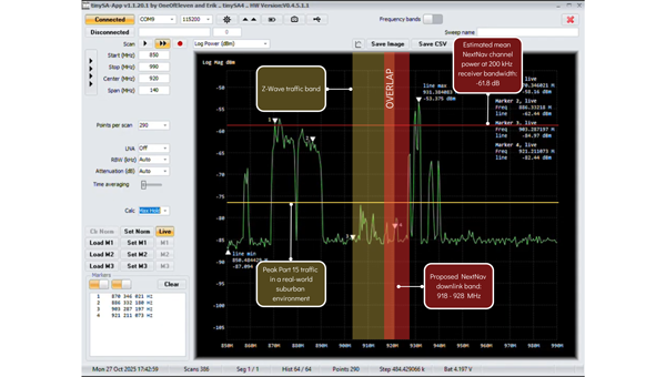
NextNav has petitioned the FCC to restructure parts of the lower 900 MHzband to host a terrestrial 5G/PNT network—essentially a ground-based GPS complement. The company’s plan would allocate parts of that band for high-power transmissions and relax the long-standing protections that keep low-power (Part 15) devices from destructive interference.
That same spectrum underpins hundreds of millions of existing systems: connected security sensors, toll-booth readers, smart meters, building automation networks, and the smart home products consumers rely on every day. These devices operate safely and efficiently because the FCC’s Part 15 rules limit interference and prohibit high-power operations in this shared public band.
Robust technical analysis, most recently the Pericle Communications study commissioned by the Security Industry Association, shows that high-power terrestrial PNT transmissions would block or degrade low-power communications up to 60 percent of the time. In plain terms, that means alarms that fail to trigger, silent sensors, and lost connectivity for devices that safeguard homes, businesses, and infrastructure.
Evidence indicates these devices could degrade significantly in performance, often to the point of un-usability. Once the band is reclassified, there’s no practical way to “retrofit” the millions of products already deployed. The result would be billions of dollars in stranded hardware, irrecoverable damage to company reputations, and a long, expensive replacement cycle for utilities, business owners, and consumers.
This isn’t an argument against terrestrial PNT. It’s an argument for evidence-based engineering.
— Avi Rosenthal
Multiple Paths to Resilient PNT
This isn’t an argument against terrestrial PNT. It’s an argument for evidence-based engineering. The Department of Transportation has identified several categories of GPS-complement technologies, including low-Earth orbit (LEO) satellite systems, time-over-fiber distribution, map matching/map tracking, and terrestrial RF. NextNav’s 900 MHz concept falls into the fourth category, but it’s only one of many.
The FCC recognized this when it opened its broad Notice of Inquiry in March 2025 instead of rushing into rulemaking. Other federally funded trials, such as the Broadcast Positioning System developed by NAB and UrsaNav’s eLoran solution, show that terrestrial PNT can be achieved without displacing unlicensed Part 15 devices.
Engineering redundancy into national infrastructure demands that we test multiple solutions in parallel, not gamble on a single proprietary approach that risks breaking what already works.
Coexistence Is the Standard, Not the Exception
Across every modern wireless domain — Wi-Fi, Bluetooth, Zigbee, Z-Wave, LoRa, Wi-SUN — coexistence testing is standard practice. Before a new technology enters a shared spectrum, it must demonstrate that it can live alongside incumbents. NextNav has not done that. Its coexistence claims rely primarily on simulations using optimistic assumptions about device density and duty cycle. Real-world deployments are far denser and far noisier.
Z-Wave and our industry partners simply ask for what every responsible engineer would: comprehensive, transparent field testing before the FCC alters the rules of a crowded band. That’s not obstructionism: it’s diligence.
Building Forward, Not Backward
Our message is simple: the U.S. needs PNT redundancy, but it must be built on coexistence, not displacement.
America’s connected infrastructure relies on the lower 900 MHz band precisely because it has been open, unlicensed, and reliable. Allowing a single licensee to flood that band with high-power signals would trade resilience for fragility.
Z-Wave Alliance stands ready to collaborate with the FCC, DOT, and all research participants to ensure the U.S. gets the GPS backup it deserves: one that strengthens, rather than undermines, the technologies that keep Americans safe, secure, and connected every day. To learn more, follow Z-Wave Alliance on LinkedIn and across social platforms: we are committed to keeping the U.S. technology community up-to-date on key proposal developments and opportunities to make their voices heard.
America’s dependence on GPS is a matter of national security, economic vitality, and daily life. We all agree: the United States must develop strong, resilient alternatives to satellite-based positioning, navigation and timing (PNT). The question, ironically enough, is how to get where we want to go.
Z-Wave Alliance, whose members build the smart home, security, and automation devices used in millions of homes and buildings, fully supports the federal effort to harden PNT infrastructure. We have been active contributors to the FCC’s Notice of Inquiry (WT 25-110) and the Department of Transportation’s Complementary PNT (CPNT) research program. We have provided and assessed technical data to help identify which terrestrial and space-based solutions can truly coexist with the technologies Americans already use every day.
A Known Risk
NextNav has petitioned the FCC to restructure parts of the lower 900 MHzband to host a terrestrial 5G/PNT network—essentially a ground-based GPS complement. The company’s plan would allocate parts of that band for high-power transmissions and relax the long-standing protections that keep low-power (Part 15) devices from destructive interference.
That same spectrum underpins hundreds of millions of existing systems: connected security sensors, toll-booth readers, smart meters, building automation networks, and the smart home products consumers rely on every day. These devices operate safely and efficiently because the FCC’s Part 15 rules limit interference and prohibit high-power operations in this shared public band.
Robust technical analysis, most recently the Pericle Communications study commissioned by the Security Industry Association, shows that high-power terrestrial PNT transmissions would block or degrade low-power communications up to 60 percent of the time. In plain terms, that means alarms that fail to trigger, silent sensors, and lost connectivity for devices that safeguard homes, businesses, and infrastructure.
Evidence indicates these devices could degrade significantly in performance, often to the point of un-usability. Once the band is reclassified, there’s no practical way to “retrofit” the millions of products already deployed. The result would be billions of dollars in stranded hardware, irrecoverable damage to company reputations, and a long, expensive replacement cycle for utilities, business owners, and consumers.
This isn’t an argument against terrestrial PNT. It’s an argument for evidence-based engineering.
— Avi Rosenthal
Multiple Paths to Resilient PNT
This isn’t an argument against terrestrial PNT. It’s an argument for evidence-based engineering. The Department of Transportation has identified several categories of GPS-complement technologies, including low-Earth orbit (LEO) satellite systems, time-over-fiber distribution, map matching/map tracking, and terrestrial RF. NextNav’s 900 MHz concept falls into the fourth category, but it’s only one of many.
The FCC recognized this when it opened its broad Notice of Inquiry in March 2025 instead of rushing into rulemaking. Other federally funded trials, such as the Broadcast Positioning System developed by NAB and UrsaNav’s eLoran solution, show that terrestrial PNT can be achieved without displacing unlicensed Part 15 devices.
Engineering redundancy into national infrastructure demands that we test multiple solutions in parallel, not gamble on a single proprietary approach that risks breaking what already works.
Coexistence Is the Standard, Not the Exception
Across every modern wireless domain — Wi-Fi, Bluetooth, Zigbee, Z-Wave, LoRa, Wi-SUN — coexistence testing is standard practice. Before a new technology enters a shared spectrum, it must demonstrate that it can live alongside incumbents. NextNav has not done that. Its coexistence claims rely primarily on simulations using optimistic assumptions about device density and duty cycle. Real-world deployments are far denser and far noisier.
Z-Wave and our industry partners simply ask for what every responsible engineer would: comprehensive, transparent field testing before the FCC alters the rules of a crowded band. That’s not obstructionism: it’s diligence.
Building Forward, Not Backward
Our message is simple: the U.S. needs PNT redundancy, but it must be built on coexistence, not displacement.
America’s connected infrastructure relies on the lower 900 MHz band precisely because it has been open, unlicensed, and reliable. Allowing a single licensee to flood that band with high-power signals would trade resilience for fragility.
Z-Wave Alliance stands ready to collaborate with the FCC, DOT, and all research participants to ensure the U.S. gets the GPS backup it deserves: one that strengthens, rather than undermines, the technologies that keep Americans safe, secure, and connected every day. To learn more, follow Z-Wave Alliance on LinkedIn and across social platforms: we are committed to keeping the U.S. technology community up-to-date on key proposal developments and opportunities to make their voices heard.
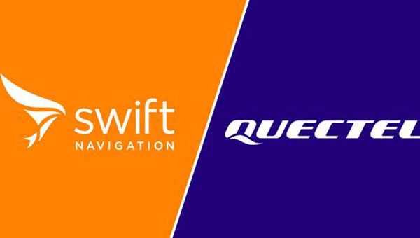
Quectel Wireless Solutions is partnering with Swift Navigation to deliver Quectel’s Real-Time Kinematic (RTK) Correction Solution, which enables cost-effective, centimeter-level positioning accuracy for a new generation of IoT applications.
In January, the companies announced integration of Swift’s Skylark Precise Positioning Service with Quectel’s high-precision GNSS modules.
The collaboration allows Quectel to simplify the complexities of high-precision GNSS by bundling its RTK modules and antennas with Swift’s Skylark Precise Positioning Service, offering equipment manufacturers a streamlined, end-to-end solution for RTK adoption and deployment.
Partnering with Swift enables Quectel to tailor solutions for specific applications, helping equipment manufacturers simplify the complexities of RTK adoption and deployment. The Quectel RTK Correction Solution is designed to support a wide range of mass-market applications, including robotics, automotive, micro-mobility, precision agriculture, surveying, and mining.
As the geospatial industry accelerates toward automation and intelligence, ComNav Technologies is redefining its role in the market. In this exclusive interview, ComNav leadership discusses the company’s transition in 2025 — evolving from a traditional GNSS hardware provider into a comprehensive solutions and services company that seamlessly integrates positioning, perception and cloud-based intelligence.
As surveying evolves from manual, point-based measurement to automated, cloud-connected ecosystems, ComNav explains how they’re positioning themselves at the forefront of this industry transformation — empowering professionals to shift from repetitive fieldwork to high-value data processing and decision-making.
What would you consider ComNav’s most significant breakthrough in 2025?
Innovation — as our slogan says, “Innovation Makes a Difference.”
In 2025, ComNav has achieved a key transformation from being primarily a GNSS hardware provider to becoming a comprehensive GNSS solution and service company. We are extending our capabilities beyond traditional receivers and boards into CORS network construction, cloud-based GNSS services, and intelligent software platforms.
This transition marks a major step toward integrating hardware, software, and cloud services, allowing us to deliver not only precise positioning equipment but also complete, scalable solutions for global customers. It reflects our long-term commitment to driving innovation and shaping the future of intelligent navigation.
What key improvements has your technology recently achieved?
ComNav has made significant progress in multi-sensor fusion and core GNSS technology.
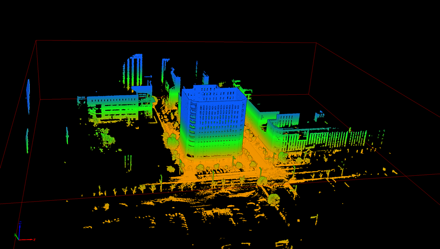
We have advanced our real-time multi-sensor fusion technology, integrating GNSS, lidar, camera and IMU to deliver higher reliability and spatial awareness in complex environments. This innovation enables a shift from point-based measurements to full 3D spatial mapping, opening new possibilities for surveying, autonomous systems, and digital twin applications.
ComNav’s real-time multi-sensor fusion technology, integrates GNSS, lidar, camera and IMU to deliver higher reliability and spatial awareness in complex environments.
How is ComNav planning to advance its multi-frequency, multi-constellation GNSS technology in 2025? Which constellations are you now supporting?
We proudly launched the fourth generation of our high-precision GNSS SoC chip, which integrates full-constellation, muti-frequency RF and BB into a single compact design. This chip offers higher positioning accuracy, lower power consumption, and improved anti-interference performance — setting a new benchmark for GNSS receiver technology.
It employs multi-constellation simultaneous equation technology, ground-based and satellite-based augmentation technologies, SBAS technology, RAIM technology to deliver highly reliable position and attitude information to users. The chip supports various positioning modes, including RTK, RTD, PPP, PDP, SPP, and GNSS + INS, making it suitable for a wide range of complex high-precision positioning scenarios.
Which industry sectors saw the most growth for ComNav solutions in 2025 – agriculture, construction, surveying, autonomous vehicles, or others? Are there any successful use cases you can share from these sectors?
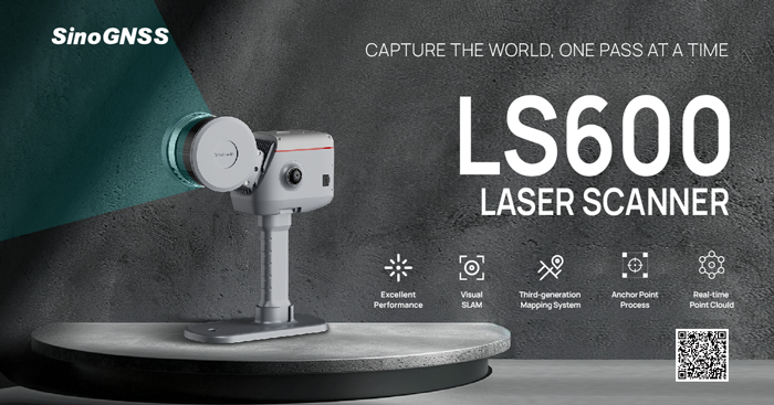
ComNav’s Jupiter GNSS receiver integrates a 50 m laser, IMUm and camera technology.
In 2025, geospatial remained the fastest-growing for ComNav.
Driving this growth is our newly launched Jupiter GNSS receiver, which integrates a 50-meter laser, IMU, and camera technology. This combination enables non-contact measurement, greatly enhancing operational efficiency.
Our newly released LS600 laser scanner further expands this innovation. It combines advanced SLAM technology, a built-in RTK module for centimeter-level accuracy, and dual wide-angle cameras for vivid color capture. The LS600 significantly simplifies field workflows and allows users to easily obtain high-quality 3D point clouds, transforming traditional “single-point measurement” into multi-dimensional, intelligent data acquisition. This represents a major leap forward in efficiency, safety, and precision for complex surveying operations.
The LS600 seeks to significantly simplify field workflows. It allows users to easily obtain high-quality 3D point clouds, transforming traditional “single-point measurement” into multi-dimensional, intelligent data acquisition.
At the same time, our agricultural segment has also achieved remarkable growth. The AG501 Pro supports a wide range of guide line designs and delivers operational accuracy of up to 2.5 cm. Continuous software updates and optimization have further improved user experience, making precision agriculture simpler and more efficient. It embodies our commitment to empowering smarter, more sustainable agricultural operations through GNSS innovation.
Are there any new product lines we can expect to see launched next year?
In 2026, ComNav will introduce a new generation of integrated lidar and RTK products, combining high-precision GNSS positioning with advanced laser scanning technology. This integration will enable professionals to capture both geometric and spatial data simultaneously, delivering faster, more comprehensive field data collection.
We are also preparing to release an upgraded handheld laser RTK, designed for maximum portability and ease of use. With enhanced measurement accuracy, longer range, and improved connectivity, it will empower surveyors to perform rapid, precise measurements in a wide range of field environments.
These new product lines reflect ComNav’s ongoing commitment to expanding its technology ecosystem — integrating positioning, perception, and intelligence into one cohesive solution.
How do you see the industry evolving over the next year, and how is comNav positioning itself to stay ahead to market changes and challenges?
We believe the geospatial industry is entering a new stage of intelligence and automation. The traditional boundary between field data collection and office data processing is rapidly disappearing. Surveying is evolving from manual, point-based measurement toward automated, intelligent, and cloud-connected workflows — where data captured in the field is seamlessly processed, analyzed, and visualized in the cloud.
To stay ahead of this transformation, ComNav is focusing on intelligent integration — combining high-precision GNSS with sensors, AI algorithms, and cloud platforms. Our goal is to enable surveyors to shift their efforts from repetitive fieldwork to high-value, intelligent data processing and decision-making in the office.
By investing in smart software, real-time cloud services, and integrated hardware platforms, ComNav is positioning itself as a key driver in building the next generation of intelligent geospatial ecosystems.
The AG501 Pro supports a wide range of guide line designs and can deliver operational accuracy of up to 2.5 cm.
Hexagon, a global leader in measurement and positioning technologies, has entered an agreement to acquire Inertial Sense, a provider of tactical-grade global navigation solutions and inertial navigation systems (INS), to strengthen the breadth of its positioning portfolio.
Inertial Sense’s capabilities seek to complement Hexagon’s assured positioning, navigation and timing (PNT) portfolio, which provides an affordable, high-performance navigation solution to users across aerospace and defense, robotics and UAV industries.
Inertial Sense has established itself as a trusted provider of high-performance navigation solutions across a wide range of defense and commercial applications, with more than 30,000 inertial systems deployed worldwide. Its patented designs and proprietary technology enable tactical-grade solutions for space-constrained applications, delivering centimeter-level accuracy with a competitive price point.
“Assured PNT is critical to success of our customers,” said Anders Svensson, president and CEO of Hexagon. “The team at Inertial Sense has developed an impressive array of GNSS+INS solutions which address the assured PNT requirements of our customers and fit seamlessly into our aerospace and defense product portfolio, while also providing opportunities for expansion into robotics and UAV applications.”
Inertial Sense, headquartered in Utah, is expected to generate revenues of around $5 million in 2025, with strong growth rates and profitability in line with Autonomous Solution’s average levels. Inertial Sense will be reported within Hexagon’s Autonomous Solutions business area. Completion of the transaction is subject to regulatory approvals and other customary conditions and is expected to be finalized in the first half of 2026.
A link to the live event will be sent to you two hours before the event. Your personalized event URL will be automatically generated by the ON24 system. To ensure receipt of the email, please whitelist this email address by adding it to your contacts: [email protected].
This presentation will begin at 1 p.m. EST on Thursday, November 20. A recording will also be sent to you the following day so you can watch it on-demand.
Audience members may arrive 15 minutes prior to live time. If you have any questions, please contact event producer Halle Reid at [email protected].
GNSS technology has had a reputation for unreliability in safety-critical applications, such as advanced driver assistance systems (ADAS). This perception has shaped automotive design and manufacturing: some ADAS developers have avoided GNSS altogether, instead relying on cameras, lidar and other sensors. Here, Manuel Del Castillo, VP of business development at Focal Point Positioning, explains how, with the right reliability, GNSS can offer a powerful layer of redundancy and support these other sensor types.
The hesitation to include GNSS in ADAS stacks is historical. Traditionally, this technology was unreliable, especially in dense, urban environments where satellite signals were obstructed. Consequently, many automakers turned to alternative sensors. For example, cameras can identify lane markings, traffic signs and objects, while lidar can build highly detailed 3D maps of the vehicle’s surroundings.
Each of these sensors provides important navigational data. However, they all describe a car’s location relative to its immediate environment. With no reliable source of absolute positioning, these relative measurements can’t confirm the vehicle’s exact place in the world — information that is critical for safe navigation.
Why ADAS Needs GNSS
Cameras, lidar and other sensors provide rich environmental data. However, they are limited by what they can directly observe. A camera can identify lane markings but can’t confirm which road the vehicle is on when multiple lanes or junctions overlap. Similarly, lidar can map obstacles in 3D, but without a wider frame of reference, it will struggle to anchor that map to the road network. HD maps provide another valuable layer, but without an accurate global position, they too can be misaligned with the real world, limiting their value.
GNSS can help plug this gap. By supplying absolute latitude and longitude, it ensures that the relative information from the other sensors is grounded in the correct location. GNSS helps calibrate and initialise other sensors, while also providing a cross-check against their measurements to detect potential errors or drift in sensor performance over time. Therefore, reliable GNSS is not an alternative to cameras, lidar or radar. It complements these sensors and boosts accuracy and the reliability of the overall system.
The Importance of Redundancy
Increasingly, the importance of GNSS in ADAS stacks is being recognised. As automotive production moves toward L3 automation and beyond, the demand for absolute positioning increases, along with the need for safe, layered sensing. GNSS, alongside cameras, lidar and radar, can help automakers improve navigational resilience without reinventing vehicular architectures.
Reliable GNSS isn’t about replacing other technologies. It is about reinforcing them. Having a global frame of reference helps ensure that the relative data from other sensors is grounded in the correct place. For automakers, the next step is recognising that GNSS can improve safety and trust in ADAS stacks, supporting the transition toward autonomous driving.
Advancing GNSS Reliability
Even with GNSS integrated into the vehicle’s sensors, challenges remain. Urban canyons and dense foliage can attenuate or even block satellite signals and create reflections, reducing accuracy. Since ADAS systems need reliably accurate absolute positioning, these challenges need to be addressed if we want GNSS to play a role in ADAS.
Newer, more sophisticated GNSS solutions are needed. The progression to Level 3 does not require an entirely new technology stack but rather extracting the very best from each of the existing components. For GNSS, this evolution involves implementing software-based solutions to achieve the necessary reliability improvements without overhauling hardware components. Pursuing cost-effective upgrades enhances performance without necessitating complete system redesigns, thereby keeping costs under control.
FocalPoint’s S-GNSS Auto software enhances GNSS accuracy in autonomous vehicles, providing reliable, absolute location to improve overall ADAS safety and efficiency. By boosting line-of-sight signals and rejecting non-line-of-sight signals, this simple firmware upgrade can help vehicles maintain accuracy in challenging environments.
By reducing positional uncertainty, these enhanced GNSS solutions strengthen the overall sensor stack. Together, these layers improve resilience, safety, and confidence in higher levels of vehicle automation.
As the automotive industry moves further towards L3 automation and beyond, reliable data on absolute position will be essential and will only reinforce the insights captured by cameras, lidar and other sensors.
India’s aviation regulator, the Directorate General of Civil Aviation (DGCA), is collecting data on GPS interference and spoofing to have a better understanding of the situation, reports several news outlets in the country. The urge to collect data comes after the Delhi airport experienced issues in the past few days.
Following a circular issued by the Directorate General of Civil Aviation in 2023, instances of GPS interference/spoofing have been reported since November 2023.
Recently, several airlines have faced GPS spoofing at the New Delhi airport, with at least eight such instances on Nov. 5, said an unnamed DGCA official. The interference instances were noticed in domestic and international flights.
Generally, interference issues are reported in border areas, rather than at Indira Gandhi International Airport, the country’s busiest. Daily flight movements have increased to more than 1,500 following an airport terminal upgrade completed in October.
As many as 465 GPS interference and spoofing incidents were reported in the border region, mostly in the Amritsar and Jammu areas, between November 2023 and February 2025.
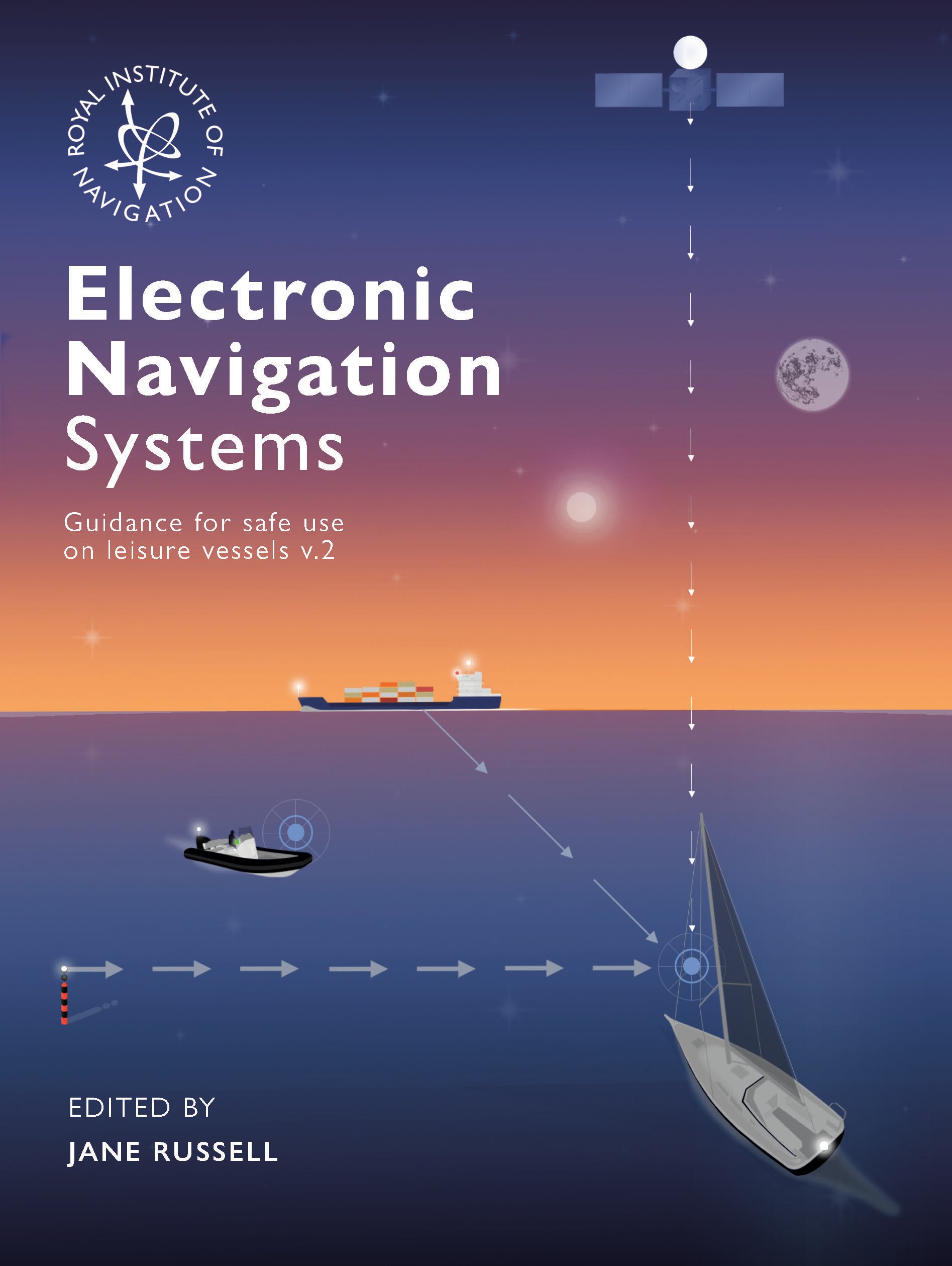
The Royal Institute of Navigation Small Craft Group has released Version 2 of a free navigation guide for small and leisure craft.
“Electronic Navigation Systems: Guidance for safe use on leisure vessels” is offered as a free digital download and as a hard copy for purchase from Bookharbour. The RIN website is asking those who want to download a copy to answer a single survey question.
Updates in the new version reflect developments in GNSS, electronic charts and their display systems, as well as feedback from readers, including a new sub-section on Astronavigation (Chapter 5).
Guidance includes
safe use of electronic navigation and associated systems on leisure vessels
“keys to safety” in many operational situations
advantages and drawbacks of different systems and approaches.
Version 1 of the “Electronic Navigation Systems” booklet is still available as a free download.
Feedback for Manufacturers
As a result of work on the first edition, published in 2020, the small craft group has compiled commendations for improvements to electronic navigation systems for leisure vessels. The improvements could be made by manufacturers and official bodies to assist the safety of leisure vessels through better design or regulation. “These recommendations did not sit comfortably in the booklet so can be viewed here,” the Small Craft Group announced.
As a result, the Pleasure Vessel Navigation Systems Working Group (PVNSWG) was set up, reporting to the UK Safety of Navigation Committee (UKSON). The Working Group’s remit is to
Propose minimum standards of functionality expected from electronic leisure charts and display systems.
Explore and consider if a means by which electronic charts and systems displaying them, which meet these standards, could be recognized by the Maritime and Coastguard Agency (MCA) for use on pleasure vessels.
Discuss with electronic chart and display system equipment manufacturers the most efficient approach to deliver proposed minimum standards and achieve recognition.