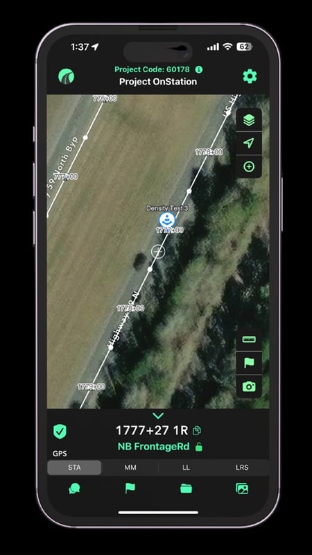
OnStation, a live digital stationing platform for road construction documentation and inspection, is collaborating with Trimble to integrate Trimble GNSS receivers with the OnStation App. Together, the technologies provide project personnel with instant, station-based context and precise location.
Previously, the ability to verify exact locations of heavy highway project assets with GNSS receivers was limited to certain field personnel. Now, construction, engineering and inspection (CEI) firms can document with confidence and accuracy, and departments of transportation can oversee projects with full visibility, without delays or guesswork.
“Location alone isn’t enough in heavy civil construction. Crews need to understand the context of what’s happening at that exact point on a project,” said Patrick Russo, CEO of OnStation. “By combining Trimble’s trusted GNSS accuracy with the capabilities of OnStation’s live digital stationing, we’re giving field personnel both precision and insight, allowing for quicker decisions, fewer errors and streamlined workflows.”
When OnStation is paired with the Trimble Mobile Manager application, the integration enhances trust in location data for paving, inspections and utilities, keeping project crews in sync. Having everyone aligned, means less risk of building in the wrong spot or misinterpreting plans.
Designed with the field environment in mind, the joining of the two offerings requires no extra hardware or complicated setup. Any Trimble R series or Catalyst GNSS receiver can be used with the OnStation App when connected through Trimble Mobile Manager. Regardless of which Trimble GNSS receiver is being used, teams can access live digital stationing while in the field by opening the OnStation App and connecting through Trimble Mobile Manager.
Trimble and OnStation representatives will discuss the integration at a virtual event, OnStation Nation, on Nov. 18. Register at https://hubs.li/Q03Qf9q-0.
OnStation is a collaborative digital stationing platform that offers location-based project records from bid to close. Specifically designed for the heavy highway industry, OnStation’s mobile app centralizes communication, boosts productivity, enhances worker safety, and improves project quality.
OnStation is available on both the Apple App Store and Google Play Store and is supported on all desktop systems.
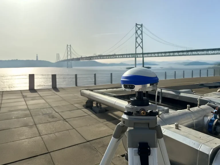
Carlson Software has released the Viking as its new flagship GNSS base/rover receiver to meet demanding needs in survey, engineering, GIS, construction, and other applications. Engineered for centimeter‑level accuracy and providing an RTK fix in challenging environments, the Viking uses Triple–Fix technology, Carlson’s proprietary GAMA RTK engine, advanced hardware, robust connectivity, and intelligent processing.
The Viking also represents the company’s second GNSS solution, after the VASCO-B base station. It is manufactured in the United States at Carlson’s headquarters facilities in Maysville, Kentucky.
“Precision, performance and reliability, all while bringing manufacturing back to the USA,” said Bruce Carlson, company founder. “The Viking is more than a positioning system. It’s a powerful tool designed to enhance your efficiency, streamline your workflows, and deliver unparalleled accuracy.”
Viking highlights
The Dual GNSS RTK modules and three separate RTK engines, provide exceptional horizontal and vertical accuracy, providing a “Triple-Fix” and essentially eliminating false fixes
Calibration-free tilt compensation delivers impressive precision even when surveying at up to 60° of inclination
Dual hot-swappable batteries: 10+ hours of runtime
IP67-rated, MIL-STD-810G tested
Use as a base or a rover with communication options including 400 MHz and 900 MHz radio, internal mobile data modem, Bluetooth and Wi-Fi
Integrates with Carlson SurvPC and Layout field software, and features a powerful web-based UI for remote setup and monitoring.
The Carlson Viking is available for pre-order through Carlson dealers and distributors worldwide.
ProStar Holdings is partnering with Tersus GNSS, a global manufacturer of patented GNSS technologies. ProStar is the developer of PointMan Precision Mapping Solutions and the LinQD enterprise integration platform.
The collaboration will deliver a complete precision mapping solution to the utility and critical infrastructure industries worldwide, the companies announced.
The partnership is designed to integrate Tersus’s survey-grade GNSS receivers with ProStar’s PointMan, providing an affordable, field-ready solution available through Tersus’s international distribution network. Tersus GNSS has operations in China, the United States, and Australia, and is recognized for its innovation in GNSS receiver and base station technology for high-precision positioning applications.
The collaboration represents the latest step in ProStar’s strategy to expand its partnerships through the LinQD open API integration platform, delivering its technologies in one connected precision mapping solution.
ProStar’s LinQD platform is designed to enable seamless interoperability between emerging technologies and legacy systems, creating a robust global ecosystem for geospatial intelligence. By uniting equipment manufacturers and service providers under this initiative, ProStar continues to strengthen PointMan’s position as a premier mapping solution for the critical infrastructure industry worldwide.
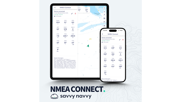
Marine navigation company Savvy Navvy introduces a new NMEA Connect feature that seamlessly integrates NMEA-enabled boat instruments with the app, providing real-time data and enhanced AIS visibility.
Working with award-winning Actisense, recognized globally for their NMEA interconnectivity specialty, Savvy Navvy’s new NMEA Connect feature enables boaters to view real-time data including wind, depth, engine RPMs, speed through water, heading and more in the app.
By combining onboard and over-the-horizon AIS, NMEA Connect delivers a complete view of nearby vessels for safer, smarter navigation. Through NMEA Connect, boaters can now access their boat’s instruments and Savvy Navvy’s smart routing technology from their pocket, eliminating the need to switch between multiple screens or devices.
“Boaters increasingly seek apps that simplify navigation and enhance onboard intelligence. NMEA Connect combines the proven reliability of NMEA technology with Savvy Navvy’s smart routing capabilities, giving boaters everything they need in one place. For boats without NMEA-compatible chart plotters, Savvy Navvy now becomes your all-in-one display,” says Misha Vysokovskiy, chief product officer at Savvy Navvy.
Actisense, global specialists in marine electronics, help leisure and commercial operators build safer, smarter and more dependable onboard networks.
“Savvy Navvy already delivers a huge amount of value to boaters, pulling together geographic location and environmental data streams. The addition of NMEA data connection means that other integral navigation and systems data will give boaters better visibility of things like depth, speed over ground, wind speed, heading and engine RPM — all within the easy-to-use Savvy Navvy app. Actisense are proud to have partnered with Savvy Navvy, lending our NMEA specialism. We share company missions of making journeys safer and more efficient through better data,” says Justin Cohen, commercial director at Actisense.
Savvy Navvy has had more than 3 million downloads globally. Unlike any other boating navigation solution, Savvy Navvy provides smart routing — giving users optimal routes and dynamic ETAs based on real-time data: departure time, chart information, weather conditions, tide, boat specifications and local regulations.
The NMEA Connect feature comes just weeks after Savvy Navvy launched an industry-first new chart annotation tool and Three Point Fix, following requests from boating instructors to turn digital charts into interactive learning tools for the next generation of boaters.
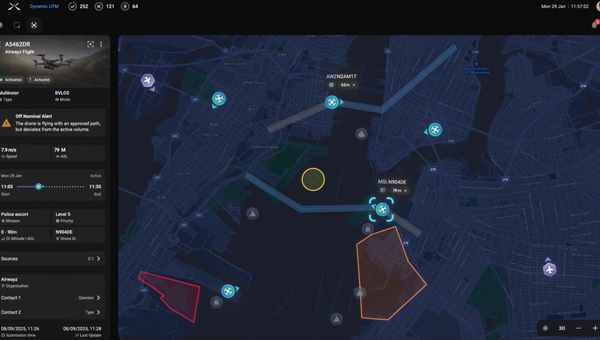
Airwayz, an AI-based unmanned traffic management company, has released a new version of its Dynamic UTM service and was awarded a research contract under the third round of the Israel National Drone Initiative (INDI3) research programs.
The new version introduces significant advancements in automation, intelligence and efficiency, providing clearer situational awareness, mitigating air risks and reducing the cognitive workload for airspace managers and drone operators, the company said.
“With the new version of the Dynamic UTM, we’ve refined intelligence, usability and automation to deliver real operational value — from planning and approval to execution and debriefing — while paving the way toward autonomous airspace management of the future,” said Yair Yosef, co-founder and chief product officer of Airwayz.
The updated system enhances workflow efficiency, communication across airspace layers and data-driven decision-making, enabling authorities to manage more missions simultaneously, safely and with greater precision, the company said.
It now provides periodic analytics and insights for authorities such as ports, airports and airspace regulators — offering visibility into trends like traffic density, mission types and operational loads. These insights support resource planning, safety strategies and potential future monetization models. Data is compiled periodically, such as monthly or at customized intervals, turning operational data into actionable intelligence.
The updated interface and AI-driven logic provide a more intuitive experience that enhances situational awareness and decision confidence, enabling users to focus on outcomes rather than system complexity, Airwayz said.
The company also upgraded its Airwayz Airplan platform, the mission management tool for drone operators.
New features include an improved drone database that speeds up flight request submissions, improves UTM communication and delivers more accurate mission statistics; duplicate flight requests that replicate recurring missions in seconds, saving more than 75% of submission time; and updates to existing flights that allow real-time changes to active or scheduled missions without cancellation.
The company’s next evolution will focus on “democratizing tactical airspace command and control,” extending from strategic oversight to mission-level defense and security.
The company also was awarded a grant to research UTM technologies and procedures as part of the INDI project, a joint venture led by the Israel Innovation Authority and partnering agencies.
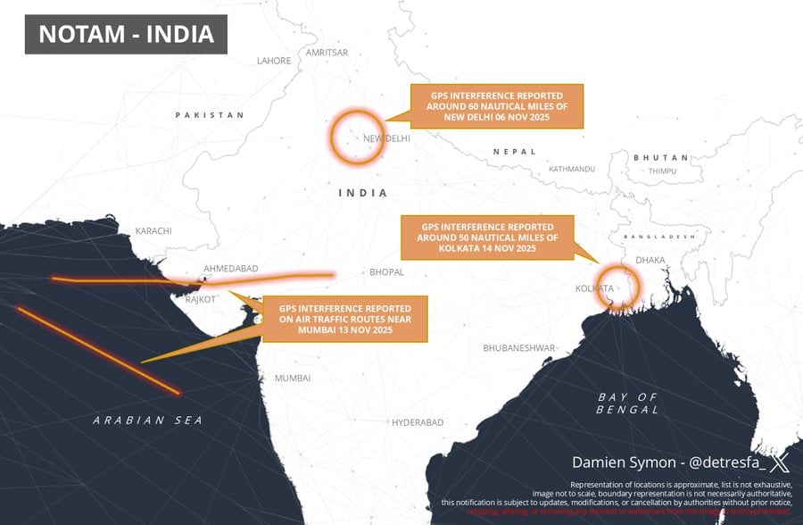
India has issued a Notice to Air Missions (NOTAM) warning of possible GPS interference or signal loss along air traffic routes near Kolkata, reports Business Today.
The NOTAM, valid Nov. 13-17, alerts airlines and pilots to remain vigilant to GNSS disruptions. It follows previous communications sharing issues with GNSS interference in New Delhi and Mumbai. Pilots and air traffic controllers also were asked to report any interference incidents within 10 minutes to the Directorate General of Civil Aviation (DGCA).
After reports of GPS interference in New Delhi & airspace near Mumbai, a new notification from India advises of similar issues now occurring around Kolkata pic.twitter.com/f4N5zd6SVB
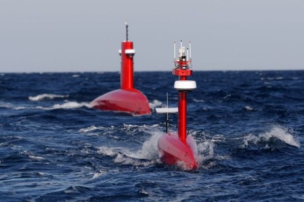
Nortek’s DVL 333 Surface, designed specifically for uncrewed surface vessels (USVs), enables USVs to maintain position or navigate when GNSS is lost.
Uncrewed surface vessels (USVs), often called sea drones, help monitor, map and secure the world’s oceans, performing tasks and surveys for less expense and risk than traditional crewed vessels. USVs are used in environmental monitoring, offshore inspection, subsea infrastructure protection, and defense missions such as intelligence, surveillance and reconnaissance (ISR).
USVs require reliable navigation and positioning information, particularly when performing autonomous operations. This information typically comes from GNSS.
But during GNSS outages, USV operators are turning to alternative sensors for positioning. Without GNSS, a sole inertial navigation system (INS) on a vessel quickly drifts outside of acceptable levels when performing dead-reckoning navigation. By adding a Doppler Velocity Log (DVL) to the USV, operators can perform long-distance, dead-reckoning-based positioning with much lower drift.
USVs using INS in the absence of GNSS achieve improved accuracy with the addition of a DVL, which limits drift inherent to INS-only navigation. (Image: Nortek)
In subsea navigation systems, DVLs provide vehicle velocity information using acoustic returns from the seabed. Because DVLs offer an accurate velocity estimate with no drift, combining a DVL with an INS constrains the drift that would accumulate with an INS alone. Using a DVL allows USVs to maintain position or even navigate without requiring GNSS information, enabling fully autonomous navigation independent of potentially vulnerable signals.
However, deploying DVLs on surface vessels introduces its own set of engineering and operational challenges. Conventional DVLs typically feature protruding transducer heads that are not flush with a vessel’s hull — challenging on smaller or high-speed vessels.
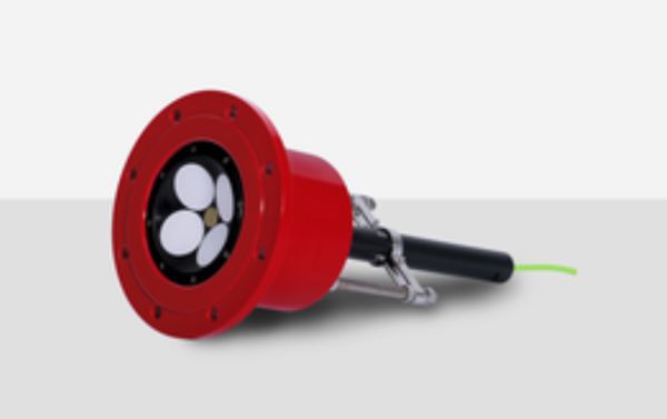
The DVL 333 Surface. (Photo: Nortek)
The compact Nortek DVL 333 Surface is designed for flush-hull installation, minimizing drag and protrusion below the hull line. It features a concave, fluid-filled transducer cavity sealed with an acoustic window, allowing for full control of sound velocity and eliminating the need for a hull-mounted speed-of-sound sensor.
When paired with a high-grade INS, the DVL 333 Surface delivers accurate position updates even during GNSS outages or interference. Its 300-meter bottom-track range supports fully autonomous operation in coastal waters, while a water-track mode extends functionality in deeper environments where the bottom is out of range. The DVL333 Surface can also be upgraded to Nortek’s VM Operations vessel-mounted ADCP system. For ease of maintenance, an optional type-certified sea valve allows in-water servicing without dry-docking.
Validating capabilities in the field
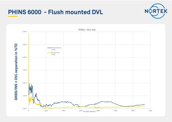
The capabilities of the DVL 333 Surface were demonstrated during field trials in the Oslofjord, an inlet in Norway. The test site presented conditions representative of complex coastal environments, where depth can vary significantly over short distances, and the seabed composition ranges from soft sediment to rock. Unlike uniform test sites with flat, sandy bottoms, the Oslofjord provides a realistic proving ground for challenging navigation scenarios.
“Our goal was to demonstrate that a surface vessel can maintain precise positional accuracy even during a complete GNSS blackout, and to do so in truly challenging coastal conditions,” said Torstein Pedersen, Nortek.
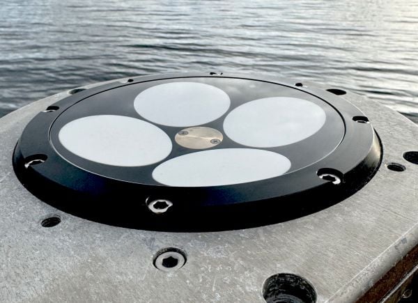
Nortek’s DVL 333 Surface installed in a fairing ready for testing in the Oslofjord. (Photo: Nortek)
The navigation tests were carried out using a DVL 333 Surface integrated with an Exail PHINS 6000 INS. Although the trial track was relatively short, the system’s performance quickly stabilized, achieving a stable, long-term accuracy of approximately 0.05% of distance traveled (for instance, 50 cm error each 1 km traveled). When bottom track was disabled (simulating operation outside of the DVL 333 Surface’s 300 m bottom track range) and only water track was used with the PHINS INS, the horizontal position error remained within 8 meters over a three-hour run, with the DVL operating solely in water-track mode. In this mode, the INS estimates background currents, which were accurately estimated as weak, stationary currents.
“We were particularly impressed with the performance of the system when using just water track mode,” Pedersen said. “The Exail INS was able to use the water track information to estimate currents and correct for them in the navigation, which is not an easy task to do with accuracy over extended periods. This performance is critical for open water navigation.”
These results confirm that the DVL 333 Surface delivers reliable navigation performance in variable bottom conditions and without a direct speed-of-sound measurement. More importantly, they demonstrate the availability of a commercially available DVL that overcomes the challenges typically faced when adapting subsurface systems for surface platforms.
Positional error as a function of distance traveled, showing long-term accuracy settling below 0.05% over a transit distance of >6 km. (Image: Nortek)
Every six minutes, somewhere in the United States, an underground utility line is damaged by careless excavation. Such incidents not only disrupt electrical, gas, and other services but also create serious environmental hazards. For example, a broken gas line could trigger an explosion that puts people and property at risk. Utilities and local distribution companies (LDCs) are embracing geospatial analytics and artificial intelligence (AI) to prevent or limit damage to buried cables and pipelines.
The Common Ground Alliance (CGA) estimates that in 2019, excavation damage cost U.S. utilities $30 billion, including the cost of lost service, emergency response, and repairs. The Pipeline and Hazardous Materials Safety Administration (PHMSA) estimates that pipeline excavation incidents continue to rise, averaging 1.45 per day in 2024.
Despite local regulations and 811 lines to “call before you dig,” excavation breaches continue to grow due to a lack of visibility and up-to-date information about underground lines. Utilities can’t give contractors and excavation crews accurate information about buried assets that are invisible from the surface.
Satellite imaging and spectral sensing technology provide utilities with the means to monitor rights-of-way, identify excavation threats, and troubleshoot problems such as gas and water leaks. AI-powered geospatial analytics are the modern canary in the coal mine for hazardous leaks and service disruptions.
Keeping Track of Buried Service Assets
Keeping track of underground assets is an ongoing challenge for pipeline operators, utilities, and LDCs. The traditional method of tracking buried assets is periodic field observations. Right-of-way inspections and 811 locate ticket programs are typically initiated before third-party excavations, but these manual methods leave a dangerous visibility gap.
Inspections are needed every 30 to 90 days, which is costly since they require rolling trucks with human inspectors. Manual inspections can also provide only limited coverage, particularly in remote and hard-to-access areas. Even with regularly scheduled inspections, encroachments may go undetected for weeks or months. The result is a vulnerability window between inspections.
The CGA reports that failure to notify 811 and inaccurate location information are among the top contributors to excavation incidents. Even when appropriate dig notices are filed, construction grading or trenching often begins before infrastructure owners can respond to dig requests.
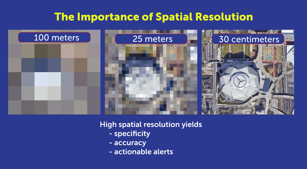
Advances in remote sensing, AI, and GIS now enable utilities to monitor rights-of-way from 270 miles up. Using satellite imaging and AI algorithms, utilities can continuously monitor pipeline and cable corridors and help close the visibility gap. Commercial satellite images from providers such as Airbus and Vantor (formerly known as Maxar) can provide high-resolution imagery for cloud-based AI processing that can detect changes as small as 30 centimeters, about the size of a dinner plate. Using satellite imaging is also faster and more cost-effective than using drones or aircraft, because cloud computing resources can analyze images in hours, rather than days or weeks.
High-resolution imagery is necessary for specific, accurate alerts. (Photo: Satelytics)
To power geospatial analytics, remote sensing technology (RST) captures multispectral and hyperspectral data from high-resolution satellite sensors, then uses AI-powered algorithms to analyze spectral signatures. Spectral imaging can detect a wide range of surface activity, including soil disturbances, vegetation changes, soil grading and trenching, new construction starts, heavy equipment use, new access roads, and encroachment on utility easements; activities that could indicate a risk to buried cables and pipelines.
Integrating Geospatial AI with ArcGIS
To make potential problems easier to identify, high-resolution images and geospatial analyses can be fused with GIS asset layers and corridor models to pinpoint anomalies that could indicate excavations or construction that interfere with utility rights-of-way.
Utilities that already use ArcGIS as their system of record can readily integrate results from geospatial analytics into existing workflows. For example, users can visualize and detect disturbed layers using ArcGIS Pro, tracking surface risk trends and KPIs with ArcGIS dashboards.
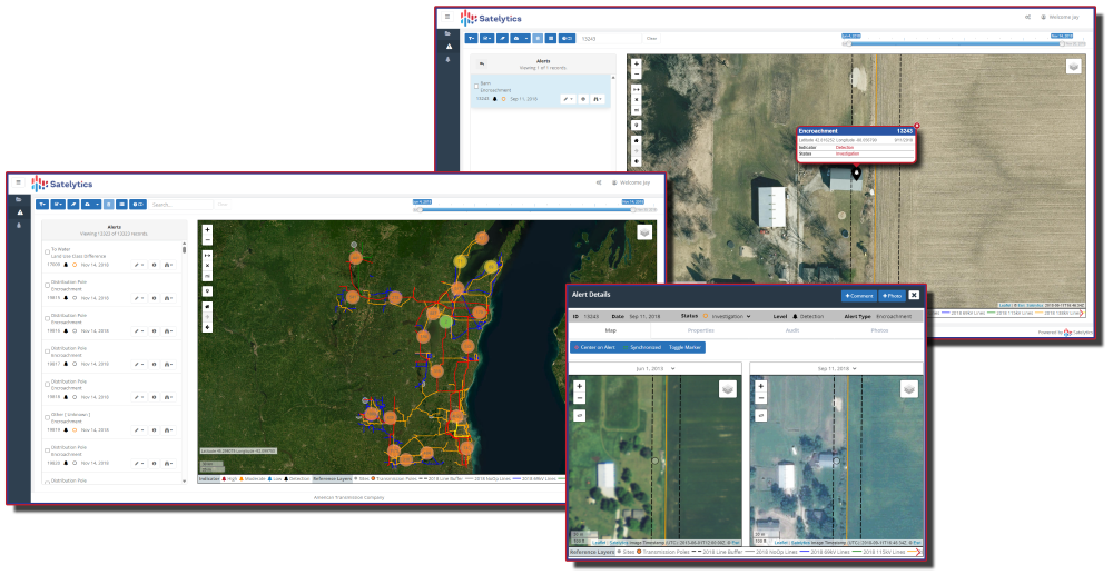
Monitoring the utility corridor for unwanted structures. (Image: Satelytics)
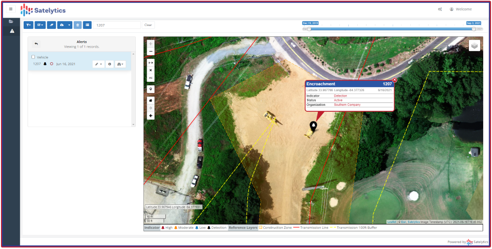
To show how this works, Southern Company, which owns Georgia Power, Alabama Power and Mississippi Power, needed to identify new construction along its service corridors to detect potential encroachments before construction. Southern Company established a quarterly monitoring schedule with Satelytics, a provider of cloud-based geospatial analytics software.
Using data from the Pleiades 1A and 1B satellites, Satelytics captured multispectral imagery at 50-centimeter resolution, then used AI-poweredanalytics to detect changes, such as new barns, parking lots, or other construction. Encroachment alerts were delivered through the Satelytics web portal, and the geospatial data was transferred directly to Southern Company’s ArcGIS system via application programming interfaces (APIs).
Southern Company then compared items flagged in the satellite images with field visits to fine-tune the AI models. Following the pilot program, the AI models were refined to flag only those encroachments that posed a danger or a problem.
Flagging encroachment risks from space. (Image:: Satelytics)
AI-powered geospatial analytics strengthens Enhanced Positive Response (EPR) by documenting risk locations, including map layers and images, and providing evidence of corridor conflicts and surface changes. While AI accelerates detection, ground truthing remains essential. As shown in our Southern Company example, on-site validation is required to improve machine learning algorithms to increase accuracy. Integrating Field Maps and Survey 123 into AI workflows can verify findings and prioritize responses.
Using AI and GIS for Predictive Dig Safety
Geospatial AI technology is becoming an essential tool for more than just excavation monitoring. Using AI to analyze satellite images offers other benefits, such as measuring gas leaks or tracking water and oil leaks. Combining AI, GIS, and historical data will soon be used for predictive excavation risk management, identifying high-risk areas in advance of filing an excavation permit.
Predictive analytics will continue to play a larger role in excavation monitoring. AI analytics will provide construction forecasts and enable permit intelligence layers in GIS. The same data can power dynamic risk scoring dashboards and support three-dimensional corridor safety twins.
As new building construction continues to boom, utilities are harnessing the latest technology to prevent excavation incidents and protect underground assets. Combining satellite imagery, AI, and GIS provides the advanced tools needed to maintain continuous asset awareness, closing the visibility gap for underground cables and pipelines. Pipeline operators, electric utilities, and LDCs are reducing operating costs and minimizing environmental impact by leveraging geospatial analytics powered by artificial intelligence.
Sean Donegan is CEO of Satelytics, a company that uses cloud-based, geospatial analytics to analyze multispectral and hyperspectral imagery to identify pipeline leaks and other environmental issues. Donegan has over 30 years of experience building technology and software companies.
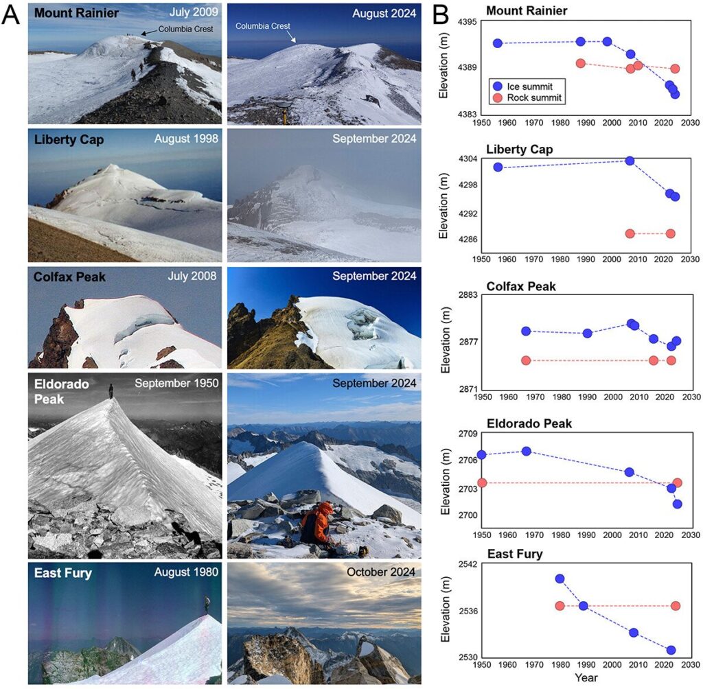
Climate change is altering summits of the tallest ice-capped mountains in the contiguous United States.
A new study by Scott Hotaling from the Quinney College of Agriculture and Natural Resources and Eric Gilbertson from Seattle University used differential GNSS measurements, satellite data, laser measurements and historical photographs to document the ways ice-capped summits in the Western United States are being affected by climate change.
For the last century, there have been five ice-capped summits in the contiguous United States, all in Washington State. The researchers measured the current elevations of the summits and compared their findings to historical surveys and photographs to assess whether their elevations have changed and whether their ice caps are still intact.
For Mount Rainier, Columbia Crest is no longer its highest point. The new summit is now rock on the mountain’s southwest rim roughly 133 meters away. All five of the historically ice-capped summits have shrunk since 1980, with four of the five shrinking by at least 6 meters (20 feet) from loss of snow and ice.
As of 2024, only two of the five summits still had perennial ice as their highest point. Free-air temperatures for the ice-capped summits indicate significant late summer warming of 2.75°C since 1950 and increases in summer melt days, with most of the change occurring since the late 1990s.
“Given the synchronous trends, we offer climate-induced loss of summit ice as the most likely explanation for the observed changes to ice-capped summits in the western United States,” the researchers write in their study.
(A) Historical (left) and contemporary (right) photographs for each ice-capped summit included in this study. (B) Elevation over time for each ice-capped summit (blue) and the nearest rocky summit (red). (Image: Study authors)
The main GNSS survey tool used was a Spectra ProMark 220 dGNSS equipped with an Ashtech antenna. GNSS measurements of the ice-capped summits hads an accuracy of ±0.03 meters. For each dGNSS survey, the researchers recorded a 1-hour measurement on the ice-capped summit. If a nearby rock summit was at a similar elevation to the ice-capped summit, a 1-hour measurement was also recorded for it.
Spirent Communications, now part of Keysight Technologies, announced PNT Xe, a GNSS simulation platform designed to expand high-performance GNSS testing across the development lifecycle. The platform aims to reduce barriers to positioning, navigation and timing testing by offering simulation capabilities in what the company describes as an economical, multipurpose platform.
The company said PNT Xe addresses challenges manufacturers face in validating GNSS performance during accelerated development schedules. The platform’s hardware supports testing from early prototypes through production line verification for commercial and military applications.
“Until now, many organizations have been forced to use unreliable, inconsistent simulators or utilize ‘live sky’ signals as a way of conducting production testing,” said Peter Terry-Brown, divisional CEO of Spirent’s positioning business. He said PNT Xe makes the company’s simulation technology available for workstations, engineers and project phases.
Terry-Brown said the platform allows developers, integrators, design verification teams and production line testers to use consistent test methodology without compromising results validity. Many leading GNSS chipsets and modules are developed using Spirent’s simulators, he said.
The compact PNT Xe can be rack or desk mounted and features an interface designed to accelerate scenario creation. The platform can operate in lab or field environments and withstand variations in temperature and vibration while maintaining performance, according to the company. It supports all GNSS constellations and frequencies and includes AES M-Code access and a removable system disk for secure testing environments.
Rob VanBrunt, CEO of Spirent Federal Systems, called PNT Xe “a game-changer for defense customers.” He said the platform’s ease of use will help deploy new PNT technology faster, allowing software engineers to test code changes at their desks. Authorized GPS M-Code users can conduct unclassified military signal testing using AES M-Code without relying solely on secure labs, he said.
Marie Hattar, chief marketing officer at Keysight Technologies, said accurate, high-performance simulation becomes critical as positioning and timing technologies become foundational to 6G, defense systems and autonomous vehicles. PNT Xe makes that capability available to more innovators to validate performance, reliability and resilience at every development stage, she said.
Built on Spirent’s 40 years of expertise, PNT Xe is designed for development and production environments including low-altitude drones, vehicles, space applications, automotive, defense, and consumer devices.
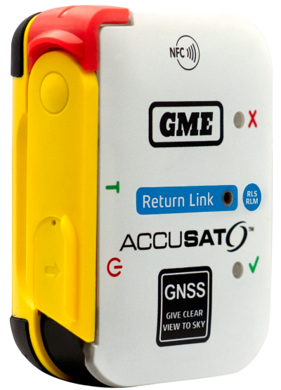
Austtralian company GME is offering its first emergency beacon with Return Link Service (RLS). RLS confirms the distress signal has reached a rescue coordination centre (RCC), providing critical reassurance in an emergency.
The MT620GR personal locator beacon (PLB), with integrated RLS and a mobile app, is a compact safety companion for outdoor and marine adventure enthusiasts.
Enhanced with GNSS for precise global positioning and a 121.5 MHz homing signal, it ensures efficient SAR operations. It is approved for worldwide Cospas-Sarsat operation.
The companion mobile app monitors the beacon’s operational status. With a seven-year battery life and a six-year warranty, it offers dependable performance and peace of mind, according to GME.
India’s Directorate General of Civil Aviation (DGCA) has made it mandatory for pilots and air traffic controllers to report GPS interference within 10 minutes of it occurring, reports Hindustan Times. The new protocol follows incidents at the New Delhi airport reported on Nov. 5.
Incidents that should be reported include position anomalies, navigation errors, loss of GPS integrity, and spoofed location data, states a three-page circular issued on Nov. 10.
The real-time reporting should include data such as aircraft type and registration, airline or operator name, date and time of spoofing occurrence, flight sector and route, coordinates or area of occurrence, type of interference and aircraft equipment affected.