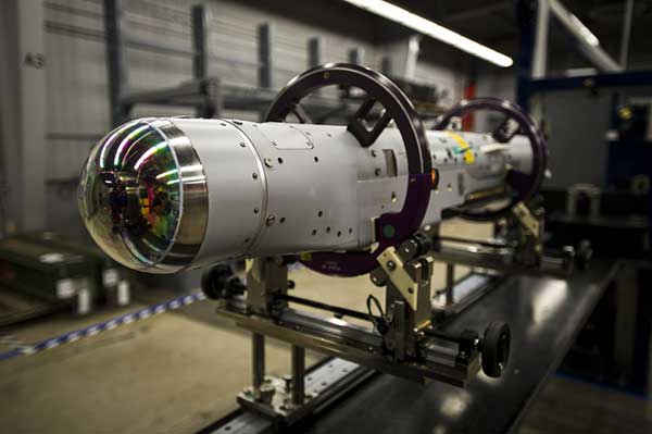
Atlantic — a remote sensing, surveying and consulting business — has purchased a Phase One Industrial 280MP large-format aerial solution to better serve its clients. The upgrade substantially increases Atlantic’s ability to efficiently capture a large area with extreme accuracy and quality.
Photo: Phase One Industrial
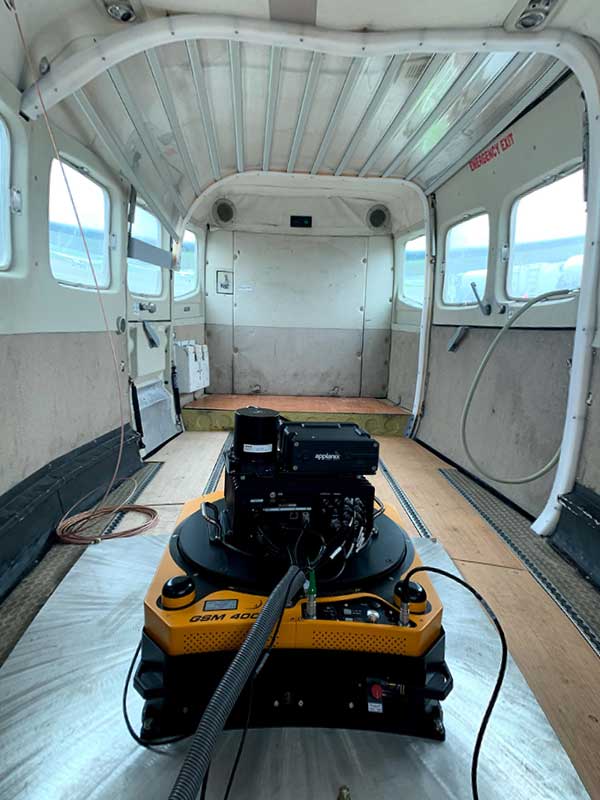
The massive Phase One Industrial 280MP aerial solution is a large-format camera system that easily integrates with smaller gyro-stabilized mounts creating a compact d lightweight system for use in a wide range of aircraft.
At its heart, the iXM-RS 280F is a dual-lens metric camera, with 90mm lenses for capturing RGB information, adding a near infrared (NIR) camera generates a four-band configuration, useful in agriculture, forestry and pipeline monitoring missions.
The iXM-RS280F camera has an image coverage width of more than 20,000 pixels whilst the cameras’ backside illuminated CMOS sensor supports very high dynamic range at 83dB. Its high light sensitivity provides superb image quality in challenging low light conditions, enabling operators to take advantage of more flight hours per day and more flight days per year.
“We’ve been using Phase One’s camera technology for over two years combined with our Optech lidar systems,” said Brian Mayfield, president and CEO of Atlantic. “We are very impressed with the technology and applaud Phase One’s innovative approach to designing a high-quality large format camera that produces exceptional results. The Phase One 280MP is yet another forward-looking technology resource that we’ve added to provide the most complete and cost-effective geospatial solutions for our clients.”
The Institute of Navigation (ION) has canceled its 2020 Joint Navigation Conference, which was scheduled to take place Sept. 8-11 in Covington, Kentucky/Cincinnati, Ohio.
According to show organizers, the decision was made because of COVID-19 and the current U.S. Department of Defense and government travel restrictions that are limiting travel.
The restricted nature of the JNC conference does not make a virtual experience possible, show organizers added.
Attendees who made hotel reservations through the ION JNC website will have reservations canceled for them, and they will receive emails confirming the cancellations. Those who booked their hotel rooms using other methods will need to contact their hotels directly to cancel room reservations.
ION JNC 2021 will be held June 7-10 at the Northern Kentucky Convention Center in Covington, Kentucky/Cincinnati, Ohio, with the classified session hosted at the Air Force Institute of Technology.
GMV will search using artificial intelligence for any correlations between COVID-19 spread and environmental parameters.
Image: ESA
The European Space Agency (ESA) has launched an internal initiative to cull ideas for supporting its member states in the study and analysis of the COVID-19 pandemic. Under this initiative, an idea from the Galileo Navigation Science Office has been selected.
The COVID-19 Space Hunting Platform is designed to facilitate access to and processing of existing COVID-19 databases for epidemiological studies, topping them up with data from ESA’s Earth observation satellites.
The project will use artificial intelligence to look for correlations between COVID-19 spread and environmental parameters, such as humidity and temperature.
The aim is to help researchers generate products and statistics that might be useful for decision-making purposes in terms of protection measures and lockdown, while also vetting the efficiency of the measures taken.
Development of the COVID-19 Space Hunting Platform will be primed by the technology multinational GMV. The Universidad Politécnica de Valencia will also be taking part, with support for processing, data analysis and interaction with diverse epidemiological research groups. The university has defined a mathematical COVID-19 transmission model and has been publishing periodical updates and forecasts of its trend in Spain.
In the medium term, the COVID-19 Space Hunting Platform could help in setting up a collaborative COVID-19 website for scientists to analyze existing data more efficiently, benefiting also from ESA’s data-processing software packages.
The GSSC team will lead the program. (Photo: ESA)
The project will be carried out around the GNSS Science Support Centre (GSSC) platform, which hosts and indexes COVID-19 data. The three-month process will analyze public COVID-19 data and make this information available to the science community. This will lead to a first version with basic pandemic-propagation algorithms, updated thereafter to ensure the information is always precise and up to date.
AiRXOS, a provider of unmanned traffic management (UTM) solutions, is providing a comprehensive unmanned aircraft systems (UAS) solution for energy organizations to plan, schedule, operate and monitor all facets of their UAS operations from a single platform.
AiRXOS’ new Enterprise Energy Solution provides digital compliance, full Situational Awareness of airspace and assets, inspection, emergency response/disaster recovery capabilities, analytics, and asset performance tools all in one, connected platform. The Enterprise Energy Solution runs on AiRXOS’ Air Mobility Platform – a secure, cloud-based, extensible platform that enables easy integration of an energy organization’s current applications and other UAS Service Suppliers (USS), as well as supports the full lifecycle of UAS Energy operations.
“Infrastructure inspections with traditional manned aircraft are dangerous, inefficient, and expensive,“ said Mark Lanphear, AiRXOS’ Senior Vice President of Global Sales and Business Development. “Now more than ever energy organizations are looking for solutions to help them deliver safe, scalable, and repeatable operations for greater economic viability. To achieve scale, they need a centralized and standardized view of all operations, manned and unmanned. It’s why we developed the Enterprise Energy Solution – to deliver energy organizations a truly comprehensive platform that brings all UAS lifecycle operations into one view — from enterprise wide infrastructure inspection and surveillance, to asset and crew management, Situational Awareness and emergency operations after a natural disaster — all on one platform.”
AiRXOS’ Enterprise Solution allows energy organizations to combine and integrate all critical inspection needs in one connected ecosystem with automated and feature-rich technology with capabilities including: Automated Waiver, Exemption and Certificate of Authorization (COAs) for safer, faster flying, partner-enabled mission-ready kits with sensors, drones, and pilots as a service, emergency response and disaster recovery application with mass alerts, digital SGI and complete situational awareness, compliance and crew management for reliability and transparency, asset management and security to optimize assets, analytics and insights for near real time actionable intelligence, and program design services to help energy companies launch and grow programs.
Syntony GNSS, a designer and manufacturer of software-baed navigation and GPS coverage extension, has partnered with Ramjack Technology Solutions, a specialized system integrator for advanced technologies in the global mining market, with the goal of driving connectivity in global mining operations.
Syntony innovations extend GPS coverage into previously inaccessible spaces, giving mining operations relentlessly reliable connectivity. This partnership will allow Ramjack Technology Solutions to further introduce enhanced connectivity into even the most rugged of global mining operations, the companies said.
“Ramjack is very excited about our partnership with Syntony and the opportunity to bring this groundbreaking technology to the mining industry,” said Mike Jackson, president and CEO at Ramjack Technology Solutions. “The need for accurate underground tracking — and the convenience of being able to use the industry-standard GPS chipsets — is a huge advantage and one that we’ve been waiting for in mining for a very long time. We’re encouraged by Syntony’s commitment to the mining industry and look forward to showing our customers how they can continue to enhance safety and production performance.”
Syntony also looks forward to the partnership.
“We’re pleased to be joining forces with Ramjack to bring our technology to the mining industry,” said Joel Korsakissok, CEO at Syntony GNSS. “We value their intrinsic understanding of integrated technologies and how to ensure advanced technology provides mines with the ultimate competitive advantage, with safety and optimisation always at the forefront. Our sophisticated solutions are perfect for their portfolio.”
The LC29D is a sub-meter level GNSS module that integrates dead reckoning (DR) and multi-band (L1/L5) real-time kinematic (RTK) algorithm technologies with fast convergence times and reliable performance. The module supports dual-band GNSS raw data output and integrates 6-axis IMU sensor to deliver high-accuracy positioning performance in seconds.
Based on the Broadcom BCM47758 GNSS chip, the LC29D can concurrently receive signals from up to six constellations (GPS, GLONASS, Galileo, IRNSS, BeiDou and QZSS) at any given time, which maximizes the availability of sub-meter level accuracy.
Combining GNSS signals from dual-frequency bands (L1/L5) and RTK technology enables the LC29D to achieve high performance even in difficult conditions such as dense urban canyons. The module can also mitigate multipath effects in urban cities.
The LC29D offers a position update rate of up to 30Hz (fusion output), enabling dynamic applications like shared eMobility, delivery robots and precision agriculture to receive position information with lower latency. By enabling easy integration of advanced RTK multi-band algorithms, the module helps developers quickly bring their devices to market.
The high-precision module offers better performance than products in the market in positioning precision, sensitivity, time to first fix (TTFF), update rates and latency.
Embedded with 6-axis MEMS sensor, devices powered by the LC29D can quickly report motion, which enables consistent high-precision positioning capabilities when combined with the DR algorithm, even in weak-signal environments such as tunnels and underground parking structures.
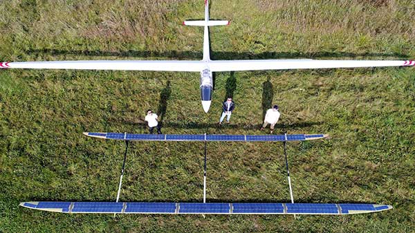
The ApusDuo project is the second generation of UAVOS’ HAPS solar airplane. (Photo: UAVOS)
UAVOS has joined the High Altitude Platform Station (HAPS) Alliance to promote the use of high-altitude solar-powered autonomous aircraft for facilitating global research missions, communication, connectivity, intelligence, surveillance and reconnaissance from the stratosphere.
UAVOS joined HAPS to collaborate with member companies towards accelerating the development and adoption of HAPS technology into the evolution of the high-altitude unmanned platforms market.
UAVOS’s HAPS knowledge is based on test flights for more than 1,000 hours of flight tests at altitudes of up to 66,000 feet (20,000 meters). The ApusDuo project is the second generation of UAVOS’ HAPS solar airplane.
HAPS platforms are autonomous, high-altitude, ultra-long endurance aircraft powered by solar energy. They are designed to boost internet connectivity worldwide, provide a long continuous monitoring of the Earth’s surface, create a network of autonomous repeaters and high-speed data signals. High-altitude unmanned platforms operate in the stratosphere, above ground infrastructure but below satellites, allowing for near ubiquitous coverage, which avoids ground clutter and significant latency issues.
The HAPS Alliance, originally an initiative from HAPSMobile and Loon, has members from the companies across the aerospace, technology and telecom industries.
According to the association, the interactive mapping-based app shows how jurisdictions have taken actions to reopen certain business sectors by issuing statewide orders. It also shows how jurisdictions are undertaking regional-based approaches or implementing statewide orders with authorization for localities to place additional restrictions.
The map also allows users to explore public health actions governors have taken during the pandemic, including statewide stay-at-home orders, limits on gatherings, state employee travel restrictions, quarantine orders for interstate travel and more.
The map, which is updated on a daily basis, features data collected from states and territories. The data is based on an evaluation of state executive orders, directives, guidance, legal and non-legal documents, and news sources, the National Governors Association said.
UAV developments are taking flight across the globe.
In one development, older technology might enable new capabilities for a pseudo-satellite UAV. Meanwhile, new technology adds significant landing capability to an Air Force drone. Finally, further trials are expected to help develop drone operational procedures and regulations in India.
Spain’s Skydweller moves to Oklahoma
An unmanned aircraft builder from Spain — Skydweller — is setting up operations in Oklahoma. This latest outfit to relocate is establishing its headquarters in Oklahoma City to develop a pseudo-satellite vehicle with a large payload capability.
For anyone who has kept tabs on the Airbus Zephyr, the UAVOS ApusDuo, The Aurora/Boeing Odysseus, or the Softbank/AeroVironment Hawk30 high-flying drone programs, you might have noticed that the stratospheric pseudo-satellite business is not easy. None have yet made it to true operational status — loitering for months at +60,000 feet and living off only sunlight, while carrying significant payloads to provide communications services. That said, some trials to date have apparently been quite successful.
All those existing UAVs are huge, flimsy, flex-wing aircraft that take an inordinate amount of care to handle in the difficult phases of take-off and landing. Airbus’ second prototype crashed in Australia in October 2019, and several other companies’ earlier prototypes have crumpled somewhat when they inadvertently contacted the ground.
Now enter Skydweller. Skydweller is designed to carry a relatively large payload and fly persistently in the stratosphere.
The payload includes one or more communications relays: 4G/5G cellular, day/night full-motion video, satellite communication, and imaging radar. This looks like it could be one capable vehicle. The makers hope to capture business in commercial and government telecommunication, geospatial, meteorological and emergency operations. Skydweller has apparently been around since 2017 and has a lot of capability, so let’s see how they do with their new venture in Oklahoma.
If you were wondering where this technology came from, it is today’s carry-over of the famous around-the-world flight by the Solar Impulse aircraft from 2016, which circled the globe without fuel, using electrical power generated by solar cells on its wings.
GA Makes Improvements with Reaper
In another life, I was quite attuned to what it took to “automatically” land a passenger jet, so a recent release from General Atomics (GA) about improving the auto-landing system on Reapers (new-generation Predators) caught my eye. GA has a U.S. Air Force contract to update these unmanned reconnaissance/attack drones with the latest and greatest, so making a working system better is one of those improvements.
Actually, GA made three changes. The first enables the drone to divert to an alternate landing zone if the planned landing area is compromised — another word to express the possibility that hostile action or weather forced home base to send the vehicle elsewhere. Quite clever, in that the alternate site might not have a ground control station, along with someone who can fly the aircraft.
MQ-9A Reaper drone, (Photo: USAF)
The ground pilot at home base has to either enter coordinates for the new alternate landing zone and the aircraft flies there and lands itself, or he needs to overfly the landing zone so that the Reaper can collect its own waypoint with which it can automatically align and land.
The second improvement has increased the speed limit of the cross wind in which the drone can land
The third enhancement allows the drone to land heavier than previously — both essential elements of being able to divert in an emergency, when weather may be poor and the aircraft could be carrying unused ordnance and fuel.
All this is a far cry from landing civilian air transports with GPS-based guidance, which is much more restrictive and with a whole mess of mathematical probabilities of the unlikeliness/likeliness of failure. Not so much for a Reaper drone on a mission during a “time of unrest.”
Home Deliveries in India
For those of you eagerly waiting for Amazon to start speedy deliveries of your online orders by drone, or Grubhub to drop in with an order of curry in a package dangling from a friendly unmanned air vehicle in your yard, there may be hope… especially if you live in India.
Following our earlier report of anticipated food deliveries by drone in India, more trials are leading to regulations and control systems. Altitude Angel from the United Kingdom has teamed with Indian Sagar Defence Engineering for a series of beyond-visual-line-of-sight (BVLOS) drone trials.
Altitude Angel’s GuardianUTM platform will be used to monitor and control these flights through real-life scenarios. Scenarios include medical and cargo transport, surveillance operations, survey and mapping, and search-and-rescue operations. Sagar will operate the cargo carrying drones; feedback from the GuardianUTM system will enable the BVLOS flights.
While the Indian government has begun to grant permission for some commercial UAV undertakings, the intent is apparently to use the output from the Sagar/Altitude Angel BVLOS trials, taking place August through October, to help develop regulations for safe operation of drones over increasingly longer distances in Indian airspace.
To sum up, intellectual property from an around-the-world photo-voltaic airplane may become a substitute for low-cost satellite TV and Wi-Fi, while auto-land is old hat for a Predator cousin and the Air Force has gained even greater landing flexibility for a principle recon/attack drone.
Finally, we can expect at least one continent to get to regulations that allow drone deliveries to become a reality at last. As usual, there is a lot cooking in drone-land….
Raytheon Missiles & Defense, a Raytheon Technologies business, completed the first guided release of a StormBreaker smart weapon from an F/A-18E/F Super Hornet, which will become the second fighter jet to add the weapon when the program reaches initial operational capability later this year.
StormBreaker features a try-mode seeker that uses imaging infrared and millimeter wave radar in its normal mode. It can also deploy its semi-active laser or GPS guidance to hit targets.
During the U.S. Navy flight test, StormBreaker safely separated from the jet and successfully received guidance data from the plane, enabling it to be directed to its target while in flight, the company said.
“StormBreaker is the only weapon that enables pilots to hit moving targets during bad weather or if dust and smoke are in the area,” said Cristy Stagg, StormBreaker program director. “Super Hornet pilots will be able to use poor visibility to their advantage when StormBreaker integration is complete.”
Eos Tools Pro implements powerful new features that enables users to exploit all four global GNSS constellations and a state-of-the-art NTRIP client to access real-time kinematic (RTK) bases and RTK networks all over the world via NTRIP, Direct IP and wireless radios.
“This is a huge step forward in functionality and flexibility for our Windows users,” said Jean-Yves Lauture, CTO of Eos. “We implemented the latest support for Windows Geolocation and other features offered by Microsoft in order to allow our customers to use high-accuracy locations directly into their apps.”
Eos Tools Pro includes new features for both field professionals and application developers.
For field professionals
RTK network/RTK base connectivity. Eos Tools Pro implements state-of-the-art NTRIP connectivity to connect to any RTK network or RTK base in the world. For geographic areas without cellular coverage, Eos Tools Pro supports Bluetooth wireless radios (UHF/VHF, etc.) for base/rover connectivity.
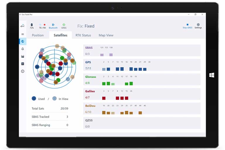
The software supports all new BeiDou and Galileo satellites in addition to GPS and GLONASS as well as SafeRTK functionality for areas with marginal cellular coverage.
Eos Tools Pro for Windows shows all current satellites in use from GNSS constellations such as GPS, Galileo, BeiDou, GLONASS and QZSS. (Screenshot: Eos Positioning)
Geoid models. Eos Tools Pro implements the latest geoid models for many regions in the world, providing survey-grade orthometric heights directly into any Windows applications.
Datum shift. Eos Tools Pro adds a new feature to apply a simple X, Y, Z shift to the current location to match any local datum.
Alarms. A vast number of audible alarms can be set to warn the user if parameters such as estimated accuracy, differential status, correction age, Bluetooth connectivity, are not met.
For Windows developers
Geolocation/Sensor API. Eos Tools Pro supports apps that rely on the Windows geolocation service to retrieve accurate latitude, longitude and altitude from their Arrow receiver. In addition, the Sensor API allows programmers to access the wide array of GNSS metadata while removing the laborious task of parsing NMEA data.
Virtual COM port and TCP/IP server. Eos Tools Pro features a built-in duo of virtual COM port and TCP/IP server to output streams of standard NMEA sentences. This enables multiple apps capable of parsing NMEA messages to have simultaneous access to the Arrow GNSS location and metadata.
“Eos Tools Pro for Windows enables users and developers to benefit from our leading-edge, high-accuracy GNSS receivers,” Lauture said. “When Windows tablets are the device of choice among our customers, the combination of Eos Tools Pro and Arrow GNSS receivers provide the absolute latest GNSS technology for GIS, engineering, construction, and surveying users. When Windows tablets are the device of choice among our customers, the combination of Eos Tools Pro and Arrow GNSS receivers provide the absolute latest GNSS technology for GIS, engineering, construction and surveying users.”
Eos Tools Pro for Windows is available for free to users of Arrow GPS and GNSS receivers. It is compatible with any Windows 10 desktop, laptop or tablet computer via Bluetooth or USB.
Following the announcement that ION GNSS+ 2020 will be virtual only this year, GPS World has decided to cancel this year’s Leadership Dinner and Awards Ceremony, which would’ve been held Sept. 24 in St. Louis.
The GPS World Leadership Dinner and Awards Ceremony is held annually at the time of (although separately from and independent of) the ION GNSS+ conference. Four innovators in the fields of satellites, signals, services and products are honored with awards in front of an audience of nearly 150 PNT industry and research community VIPs.
“This was not a decision we took lightly as so many of us look forward to wrapping up the conference by honoring deserving colleagues over a nice meal followed by a fun activity,” said Marty Whitford, GPS World’s group publisher and editorial director.