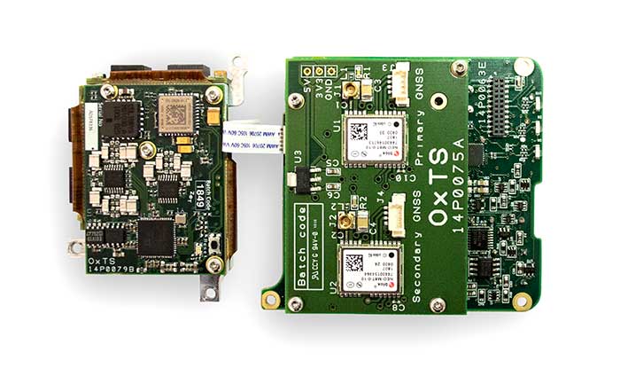
The xOEM v3 includes the architecture from the company’s IP65-encased xNAV v3 as well as a full range of software interfaces, providing integrators maximum configuration flexibility, real-time monitoring, post-processing and analysis. Software interfaces can be customized using the OxTS NAVsuite. Plugins can be created using the company’s NAVsdk, allowing the xOEM v3’s software to be easily packaged and included as part of a product.
The board set is compact at 150 grams, which enables manufacturers to seamlessly integrate and build a high-performance INS into their products, such as commercial mapping applications on land and in the air. Its light weight means more payload capacity for other critical components. An add-on lidar georeferencing software package is also available with a sophisticated boresight calibration tool.
The high-grade MEMS inertial sensors and real-time kinematic (RTK) capable GNSS receiver within the xOEM v3 board set deliver high performance capabilities. The board set provides 0.1° heading accuracy, 0.05° pitch/roll accuracy and 2 cm global position accuracy.
GNSS positioning is highly accurate and reliable — until satellite signals are disrupted. Hexagon | NovAtel has developed SPAN technology that integrates GNSS positioning with inertial measurements for a three-dimensional understanding of position and orientation.
SPAN technology delivers accurate heading, velocity, azimuth, pitch and roll. NovAtel SPAN-enabled receivers and enclosures are effective across applications, including marine environments to monitor heave movements from waves and autonomous vehicles requiring a higher level of precision and integrity.
NovAtel has demonstrated SPAN technology’s capabilities in a sensor-fusion project alongside AImotive and STMicroelectronics. Leveraging sensors on a moving vehicle — GNSS, inertial measurements, and cameras for visual odometry — allowed the teams to produce promising results for continuous positioning on real roads, in underground parking garages, and through tunnels. NovAtel’s PwrPak7-E1 enclosure was used as a reference system in the project, gathering data to confirm the accuracy of the sensor-fusion solution.
Through this project, NovAtel and its partners validated how alternative PNT like SPAN and other sensor fusion solutions complement and extend GNSS positioning availability, accuracy, and reliability.
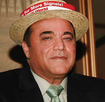
Dr. Javad Ashjaee, Founder and CEO of Javad GNSS, 1949–2020. (Photo: Javad GNSS)
The GNSS community was deeply saddened by the loss of Dr. Javad Ashjaee — Javad, as he liked to be called — on May 30. Following are excerpts of comments by GPS World Editorial Advisory Board members and others, all of whom also expressed their heartfelt sorrow.
Message from The Ashjaee Family
“Once in a while an individual comes along with a spirit seemingly superhuman, a resolve and constitution seemingly indestructible. Dr. Javad Ashjaee was one such individual. His talent, intellect, commitment and sheer guts were head and shoulders above the rest, much to the chagrin and frustration of his competitors and naysayers. But those closest to him know that he was also simply, beautifully, erringly human. He brought out in the rest of us the strength and wisdom we could not always see in ourselves. Yes, he was a force of nature, as many describe, but Javad never did anything alone. Throughout the years, he has had a sizable family and team, by blood as well as by love, behind each of his many achievements and contributions to his field. He once told us his name, Javad, means ‘generous.’ And that he was. All that he has given to, and all that he has inspired in, his family, team, and professional industry, forms a legacy that will continue for years to come. We, his family, his team, his protégés and protectors, are here to stay and stronger than ever. If he were here, he would surely wonder how his competition would proceed without that fire only he could ‘light up their asses.’”
Jules McNeff VP of Strategy and Programs Overlook Systems Technologies
“Javad was a brilliant innovator, although he could be a bit infuriating at times. He loved to place ads in GPS World in part to poke fun at the DoD for our Selective Availability policies, for which I was the principal defender at the time. Javad was a unique and talented person of tremendous fortitude and intellectual confidence who was never afraid of controversy. The GNSS community will miss his energy.”
Mitch Narins CISSP/FRIN Strategic Synergies
“When I think of Javad, the words that come to mind are ‘brilliant, dedicated, driven, and committed.’ The last time I saw Javad at an ION GNSS+ conference, he knew he was on the side of an argument opposing many other experts in our GNSS community. That did not bother Javad. He was never one to go along to get along — which was one of the reasons he was able to develop such innovative and capable systems. Our GNSS community has lost a leader, innovator and contributor to the science and engineering behind position, navigation and time.”
Paul McBurney Ph.D., CTO and co-founder OneNav
“Javad was a one-man army who was not afraid to fight. From his days at Trimble, where he developed major advancements in receiver software, and through all of his endeavors, Javad produced an impressive amount of truly innovative solutions. He used the LightSquared crisis as an opportunity to add novel front-end filtering to his products, and cleverly marketed it. His writing was unmistakable, featuring the wordsmithing of both an engineer and a salesman. He was a role model to many aspiring GPS entrepreneurs.”
Tim Burch Director of Surveying SPACECO
“Javad’s contributions to the surveying profession helped turn every practitioner into a geospatial information provider. From his early days at Trimble pioneering the commercial-grade receiver to creating his company at Ashtech and embracing GLONASS with GPS, he continued to expand the capability of the GNSS receiver. Many surveyors today, however, only know his name through his latest company, Javad GNSS, and its unique line of receivers and measuring devices, with their distinct green color. Javad was a big part of the GNSS revolution, so the next time someone starts up his/her receiver to collect survey data, take a moment to thank him. His departure leaves a giant hole in the geospatial world.”
Michael Swiek Managing Director, Executive Branch and International GPS Innovation Alliance
“The ‘Original Cast’ of GPS innovators is dwindling. Javad was a complicated, self-made, innovative, and entertaining man. In the many years we knew each other, we worked on shared visions, many challenges, laughed a lot, and disagreed and argued more than a bit. We always remained friends, honest to each other. Javad was a true GNSS pioneer.”
Ellen Hall President and CEO Spirent Federal Systems
“What a loss for everyone. Such a talented person who truly made his mark on the world.”
Greg Turetzky consultant
Dr. Ashjaee leD the signals team of the “Satellites vs. Signals” after-dinner debate at the GPS World Leadership Dinner held during ION GNSS 2008. (Photo: GPS World)
“I have very fond memories of Javad from the many years we attended
ION GNSS+ and other industry conferences. I will always remember a spirited ‘Satellites vs. Signals’ debate we had at a GPS World Leadership Awards Dinner. We were equally passionate about the debate — despite not having chosen the opposite sides to which we were attached. These are the memories of Javad I treasure. He was passionate, informed, innovative and really good at playing the game. His spirit of innovation will be missed, but I am confident it will be carried on by other members of the GNSS community of which he was such an important part.”
Alison Brown President and CEO NAVSYS
“I am so sorry to hear about Javad’s passing. He was an innovator and an originalist. We worked together after he left Trimble and was in the process of starting Ashtech. I particularly remember his championing the cause, with me, against Selective Availability. He ran an ad with the iconic image of the Mona Lisa as part of this cause, with the slogan “Why ruin a work of art?” It is tragic that Javad fell victim to COVID-19. He will be sorely missed.”
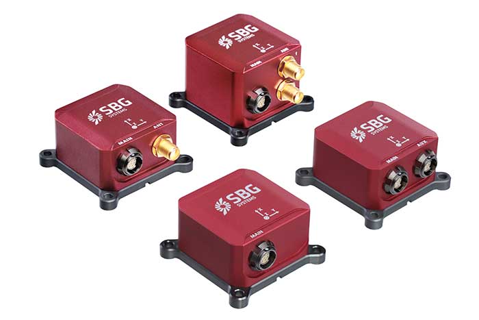
Third Generation of the Ellipse Series of IMUs. Clockwise from top: Models D, E, A and N. (Photo: SBG Systems)
Not just supporting players, alternative positioning, navigation and timing (PNT) systems strengthen, augment and — when needed — replace GNSS. GPS World explores how companies are using alternative PNT, and talks with Alexis Guinamard of SBG Systems about the company’s latest developments.
GPS World: What are the main challenges to GNSS that require developing alternatives?
Alexis Guinamard: GNSS technology can be easily disturbed by a wide variety of factors. Urban canyons or foliage environments can obstruct GNSS signals or cause multipath effects. Intentional and unintentional jamming and spoofing are also a big concern for PNT users.
Alternative technologies are developed to add robustness to GNSS positioning and useful features like orientation tracking (inertial + GNSS), or ultimately to work in pure GNSS-denied environments (SLAM).
GPS World: What is your range of products?
AG: We develop and produce GNSS-aided inertial navigation systems, but also provide a post-processing software (Qinertia). Our latest innovation is the third generation of the Ellipse series — our best-selling product — which is an industrial-grade INS. Based on the same inertial core, we integrated cutting-edge technologies, such as a multi-frequency GNSS receiver and RTK capability, within a miniature form factor.
A multi-constellation, multi-frequency receiver is much harder to jam or to spoof, which makes the Ellipse-N very robust and able to operate despite interference.
Finally, the new Ellipse-D, which provides dual-antenna heading capability, has been drastically improved in terms of size, weight and power.
Our post-processing software is compatible with all our INS products. So, we can post-process these data to obtain centimeter precision in a PPK mode. Qinertia is running a tightly coupled navigation filter to obtain the best navigation performance in post-processed applications.Thanks to the raw data output of the Ellipse’s sensors, it’s really straightforward to do post-processing with Qinertia PPK software and obtain the highest level of accuracy.
We worked hard to make the user experience as easy as possible. The latest version of Qinertia allows the customer to process either INS systems with GNSS or purely GNSS data.
GPS World: What are primary uses of your systems?
AG: We have many advanced robotics applications, including UAV, driverless cars, and agricultural robots. We divide them into mapping applications, remote-sensing applications and control applications.
Inertial sensors can help a lot for the control applications because we are able to reject false GNSS measurements in both loosely and tightly coupled schemes. We can also use them to provide a precise heading, which is required by many of these applications. So, I would say that advanced robotics is one of the major growth areas for us.
Not just supporting players, alternative positioning, navigation and timing (PNT) systems strengthen, augment and — when needed — replace GNSS. GPS World explores how companies are using alternative PNT, and talks with John Fischer of Orolia about the company’s latest developments.
GPS World: What are Orolia’s latest advances and products regarding alternative PNT?
John Fischer: Regarding timing, which we have been doing for decades, our big alternatives to GNSS are internal atomic clocks and network-based timing, such as precision time protocol (PTP). Regarding positioning and navigation, the two areas on which we focus are IMUs and getting updates from GNSS, so that, when you lose GNSS momentarily, you have something on which to coast. The breakthroughs in MEMS technologies are astounding —they are getting better and cheaper every day. That shows wonderful promise.
The other area is doing satellite navigation using low Earth orbit (LEO) satellites, which are much closer to the Earth than GNSS ones and give you 30 dB or more of signal strength. We are focused the most on the Satellite Time and Location (STL) signal because it is available today. Supplementing your navigation system with updates from LEO satellites provides you some great non-GNSS navigation capability.
GPS World: The positions of LEO satellites are not monitored as closely as those of GPS satellites. Is that an issue?
JF: That is correct. You are losing accuracy by using what is available today because you do not know the positions of those satellites as well as you know those of the GNSS satellites and maybe you do not have the best geometry. All the GNSS satellites are in medium Earth orbit (MEO) because they have much better geometries for a small constellation. With just 24 satellites in MEO orbit, you get great geometries. When you go lower, you need an increasingly greater number of satellites.
The first generation of LEO satellites, the Iridium STL, are a much larger constellation, with 66 satellites, but still not enough to give you the good geometries. Today, you are getting less accuracy, but there are all kinds of new satellites being launched and the capability to track them will improve. We expect to be able to use signals from hundreds, if not thousands, of LEO satellites, so the geometry problem will start to go away and there are other things we can do to improve the accuracy. Meanwhile, we can get rather good performance with what we have today.
GPS World: What are some of your most recent advances, releases or products?
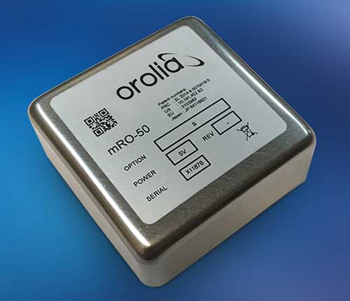
JF: On the timing side we have what we call a mini-Rubidium, the mRO-50, which we launched on June 4. Smaller, better, cheaper atomic clocks are coming out very soon.
GPS World: Do you have any comments on the recent executive order on resilient PNT?
JF: We coined the term “resilient PNT,” so we are glad to see it in use. We fully support those efforts.
GPS World: What about other alternative sources of PNT data, such as radar, lidar and signals of opportunity?
JF: Yes, they are that next level. Loran is ideal because it is so different from GNSS. When you are trying to design a reliable system, you want a lot of diversity, because if two systems have the same kinds of failure modes you have not gained in redundancy. Loran is literally at the other end of the spectrum from GNSS: It is a low-frequency microwave system. Instead of being space-based, it is land-based; instead of being low power, it is high power. However, there still are no stations up. It requires big equipment, so it will take some time.
When it comes to what you can do today, Loran does not contribute much. We support efforts to implement Loran very much, because we do need non-GNSS ways to make things resilient. Prior to GPS, we had to depend only on Loran. Today, with modern digital signal processing (DSP) techniques and receivers, I think we can expect the new Loran system to have much better accuracies than we had in the bad old days of the first generation of Loran.
The auto industry is doing a marvelous job of doing navigation using lidar or cameras. They are pretty much navigating driverless cars the way that humans drive, by just using visual cues. Those things have promise in certain unique areas.
The basic ArduSimple RTK kit includes Sapcorda SAPA. (Image: ArduSimple)
ArduSimple has integrated Sapcorda’s SAPA Premium Service into its new simpleRTK2B+SSR GNSS receiver. The user-friendly integration based on SSR technology allows plug-and-play real-time kinematic (RTK) without the need for a base station. Users can connect the receiver to their PC or tablet to achieve centimeter-level accuracy.
Based in Berlin, ArduSimple develops user-friendly, affordable RTK receivers and tools for evaluation of multi-band GNSS technology.
The simpleSSR basic starter kit includes a multi-band RTK receiver, SSR receiver, one year unlimited data package and one year SAPA Premium license. Accurate position is available via USB, UART and I2C, as well as via Bluetooth, Wi-Fi or RS232 with the corresponding accessory.
“ArduSimple’s vision is to make RTK technology affordable and accessible to everyone. Removing the hassle of the base station is a key step towards it,” said Josep Olivart, Senior Consultant at ArduSimple. “The decision to select Sapcorda was clear: best in class service performance at affordable mass market price, supported by a highly skilled and committed team.”
Sapcorda provides GNSS augmentation services for the internet of things (IoT), automotive, and industrial applications across the United States and Europe including up to 20 kilometers off coastlines, delivered with low-bandwidth data over internet and satellite, and providing uniform, high-integrity instantaneous sub-decimeter positioning on a continental scale with enterprise-level service availability.
“Sapcorda aims to establish GNSS precise positioning in mass-market applications and ArduSimple is an ideal partner for the integration of our services into a high precision GNSS hardware,” said Botho Graf zu Eulenburg, managing director at Sapcorda. “The combination of our advanced services with ArduSimple’s new platform provides an easy to use and affordable high precision solution to everyone.”
On June 25, 1945, ION held its first organizational meeting on the Los Angeles Campus of the University of California.
According to ION, 55 people attended this meeting, where a “temporary” organization was established until a general meeting could take place in the fall when articles of incorporation could be drafted and adopted, council members elected and the vision for ION could begin to take shape.
The global impact of ION has been documented in its more than 2,600 technical papers that have been published in Navigation, the Journal of the Institute of Navigation. Navigation was first published in March 1946.
The Institute of Navigation is a non-profit professional organization advancing the art and science of positioning, navigation and timing.
As part of the effort to combat the spread of COVID-19 in the United States, UAV company Draganfly has partnered with Australia’s Department of Defense (DOD), the University of South Australia (UniSA) and Vital Intelligence, a company that collects and analyzes healthcare data, to remotely detect and monitor people with infectious and respiratory conditions.
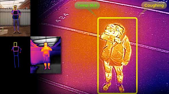
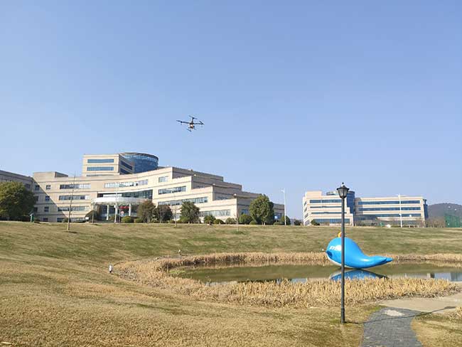
Draganfly’s UAVs will be fitted with a specialized sensor and computer vision system that can monitor people’s temperature, heart rate, and respiratory rate, as well as detect people sneezing and coughing in crowds. The collaboration, called The Vital Intelligence Project, utilizes technology developed with help from the DOD’s Science and Technology Group. Draganfly was selected as the exclusive integration partner on March 25, with an initial budget of up to $1.5 million to commercialize and deploy the technology.
The UAV uses u-blox LEA-M8S GNSS modules integrated into the company’s own interface printed circuit boards.
In late January, recalled Draganfly’s CEO Cameron Chell, the company began to consider what kinds of health data it could collect and analyze that could help public officials and private-sector managers flatten the pandemic’s curve. It then contacted Javaan Chahl, a UniSA researcher who had been a customer for 20 years, to discuss the use of UAVs for this mission.
The technology was originally designed to be deployed on helicopters in disaster relief operations, to measure the vital signs of survivors. It was then adapted to measure the health of wildlife populations, such as herds migrating or threatened by drought or fire, and in hospital neonatal wards to monitor the vital signs of newborns.
To provide core temperature readings as well as measurements of heart rate and respiratory rate, the technology uses RGB and thermal cameras, both fixed and mounted on UAVs. “The public sector and the private sector are both interested in this technology, but are approaching it very differently,” Chell said.
The system’s capabilities include detecting people who are coughing, not wearing masks, or clustering in violation of social-distancing rules. The objective is to provide population health information to public agencies to help them make better decisions by measuring the effectiveness of their COVID-19 policies in real time, rather than react to past information. The system, Chell stressed, does not record data on individuals but reports such figures as “84% of the people are socially distancing 24% of the time.”
“Based on what I see unfolding with the measurement and data industry as it relates to health technology,” Chell said, “six or eight months from now you are likely to see health measurement reports the same way that you see weather reports. Eventually, it will be broadcast to the consumer. That is our objective.” People, he predicts, will use these reports to make decisions about where and when to travel.
To obtain accurate core temperatures, Draganfly’s thermal sensor needs to be about 20 feet away from its subject, and uses software to zoom in on the tear ducts. To obtain heart and respiratory rates requires about 25 seconds of footage with at least a 4K camera, magnification to detect body micromovements, and machine vision to detect skin tone biometric measurements. The system also picks up movements — such as of the shoulders, lumbar area and upper torso — that indicate coughing, Chell points out. “The results certainly have been promising in terms of having real quantitative data,” he said.
The scenario is somewhat different in the private sector, which typically relies more on fixed-based cameras for entranceways — for example, to monitor workers entering a warehouse, a factory or a shipyard to guard against people who are infectious or have a respiratory disease. “We have seen several announcements by companies that they are using thermal cameras to do this,” Chell said. People pass through the company’s fixed system, which uses both thermal and RGB cameras, in less than three seconds, according to Chell, which is good for such facilities as parks, office buildings and convention centers. Private organizations can then ask people who exhibit certain symptoms to consent to a secondary screening in exchange for access.
Additionally, Draganfly will provide UAV services for disinfecting outdoor facilities.
Find out how more companies are helping fight COVID-19.
San Francisco, captured by HERE’s 3D mapping technology. (Image: HERE)
In 1854, English physician John Snow mapped the London cholera epidemic to determine the exact location of a contaminated water pump on Broad Street, pioneering the use of location mapping and data to manage public health crises.
Today, governments and public health officials are utilizing location data to help fight the COVID-19 global pandemic. Location data and maps are at the frontlines to aid emergency responders and healthcare providers, while GIS professionals, data scientists and many others rely on maps and location data to allocate supplies, manpower and assets where they are needed most.
Data as a source of truth
Location data has been one of the most valuable tools to guide crisis response. By referencing professionally managed, comprehensive geospatial databases, public health officials are able to precisely locate key medical and emergency resources, including hospitals, medical centers, medical and emergency services, pharmacies, and food and water distribution centers.
For example, the HERE location platform continually validates the freshness and features of its map through thousands of data sources. This includes field-collected data, third-party data from government sources, and crowdsourced data from expert communities. Taken together, the process rapidly delivers clear, timely location information to end-users such as key medical stakeholders.
It is critical that all levels of government — local, state and federal — have access to these types of valuable datasets during times of emergency. In response to the pandemic, we have seen incredible agility from facilities that have been converted to provide critical medical services.
For example, the Javits Center in New York City has been used as a field hospital, a sports facility has been converted into a drive-through testing center, and schools are being used to distribute food. By tracking these updates, authorities have real-time awareness of these facilities and their availability to provide services.
Use Case #1
Social distancing efficacy
At this stage of the pandemic, the Federal Emergency Management Agency has tapped into location data to track the efficacy of social distancing policies and the spread of the virus. It’s valuable to map the virus’s spread for many reasons, but a few key reasons include:
Predicting the movement of COVID-19. By mapping the spread, we can proactively align the medical supply chain behind these predictions.
Understanding the effectiveness of social distancing. Social distancing is one of the most powerful ways to stop the spread of the virus. By tracking the efficacy of these measures and regulations and ensuring that citizens are complying with shelter in place, we’re able to predict how we are able to slow or flatten the spread.
Predicting the economic impact. As we consider reopening America for business, it’s important to understand where the virus is most prevalent, and the timeline for recovery.
Use Case #2
The strained medical supply chain
The coronavirus has caused strain across most industry supply chains, but most notably, the medical supply chain. Medical resources, including hospital beds, masks and life-saving ventilators have become scarce and unevenly distributed.
In times of crisis, with thousands of lives at stake and the potential for further economic fallout, it’s critical that public health officials are equipped with authoritative, comprehensive datasets to guide decision-making. When organizations are equipped with this valuable data, they can harness the power of location data for good and follow in the footsteps of the location data pioneer John Snow.
In early February, TopXGun Robotics — based in Shanghai, China — started to use 10L drones for spraying disinfectant to help fight COVID-19. Six volunteers provided free disinfectant spraying service to more than 10 large companies, factories and universities, covering about 800,000 square meters in the Shanghai area.
TopXGun outlined the advantage drones have over manual spraying.
Safety. Using a UAV means no wokers inhale disinfectant. Pilots stay distant, and no one enters a sprayed building until it is safe.
Effectiveness. By spraying from above, drones can reach difficult locations, such as a landfill or a roof. Reportedly, the spray can kill the virus in the air.
Cost-savings. Only one pilot and one assistant are required to operate, reducing labor costs.
The 10L drones are equipped with Septentrio’s high-precision GNSS, which provides robust anti-spoofing and anti-jamming capabilities, important in urban areas.
Before spraying, TopXGun used a XC-05 vertical-takeoff-and-landing (VTOL) drone to survey the area. With reliable real-time kinematic (RTK) technology from the Septentrio receiver, the survey drone accurately generated a map of the operation area, marking the flight route. In this way, the spraying drone could fly and spray automatically in most cases. If the operation area is in an irregular shape or has obstacles in the middle — such as poles or trees — the mapping pilot can use markers to indicate these obstacles so the spraying drone will avoid it.
City officials in Sarasota, Florida, kept their staff actively working during COVID-19 social distancing mandates by training and tasking them with mapping utility data in the field.
The city’s plan to rebuild its GIS database had an estimated five-year timeline. GIS Coordinator William Rockwell suggested to city manager Tom Barwin that those unable to work from home be trained to collect the data. Rockwell worked with Sarasota IT Director Herminio Rodriguez to calculate the cost of acquiring enough GNSS receivers for the idle staff to use, and discovered a substantial cost savings.
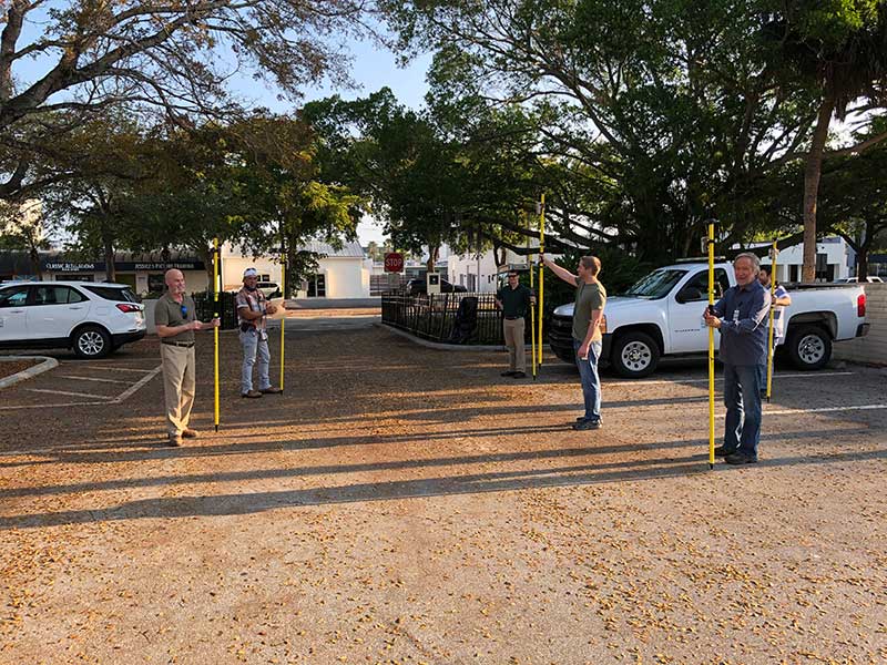
Hands-on training took place in the Sarasota City Hall parking lot, with trainees practicing social distancing. (Photo: Eos Positioning)
“By implementing this project, we not only keep city staff productive, but we’ll also be collecting data that would otherwise cost hundreds of thousands of dollars if we outsourced the work,” Rockwell said.
Training from a Distance. Rockwell obtained affordable Arrow 100 GNSS receivers from an Eos Positioning distributor and hosted small-group training sessions in the city hall parking lot. Employees from a multitude of different departments were trained, such as a parking enforcement officer and a transportation planner.
All employees were carefully kept six feet apart. From a maintained distance, Rockwell explained the basic concept of data collection using high-accuracy Arrow 100 receivers with ArcGIS Collector.
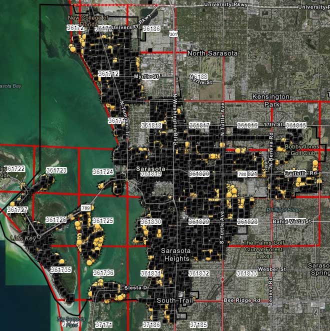
The new team mapped 93% of street lights and road signs in one month. (Photo: Eos Positioning)
The employees took turns collecting sample data so Rockwell could address any initial concerns. He also gave each of them a printed map series, created in ArcGIS Pro, that showed the city divided into 28 grids. This allowed the team members to easily mark off where they collected data each day.
At the end of each day, the workers synced their data, collected by the Arrow 100s, to ArcGIS Online, which allowed Rockwell to monitor progress.
To date, 14 field workers have collected 93% of the city’s 6,000 street lights and 16,000 road signs. Although the 30-day project pilot has finished, the city plans to collect the remaining lights and signs, as well as the city’s 35,000 trees, later this year. High-accuracy GIS data collection has received encouraging feedback from management.
“I’m thrilled the city is supporting this initiative,” Rodriguez said. “To be able to take employees doing very, very different jobs and put them in the field — this wouldn’t have been possible in a normal environment. We are excited that everyone is chipping in.”
An international survey and analysis on GNSS interference detection and localization systems reveal the path forward for transportation and other critical infrastructure.
By José Luis Madrid-Cobos and Ana Bodero-Alonso, ENAIRE
Ignacio Fernández-Hernández and Eric Châtre, EC
Andriy Konovaltsev, DLR, and Christopher Hegarty, MITRE
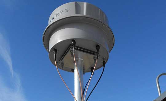
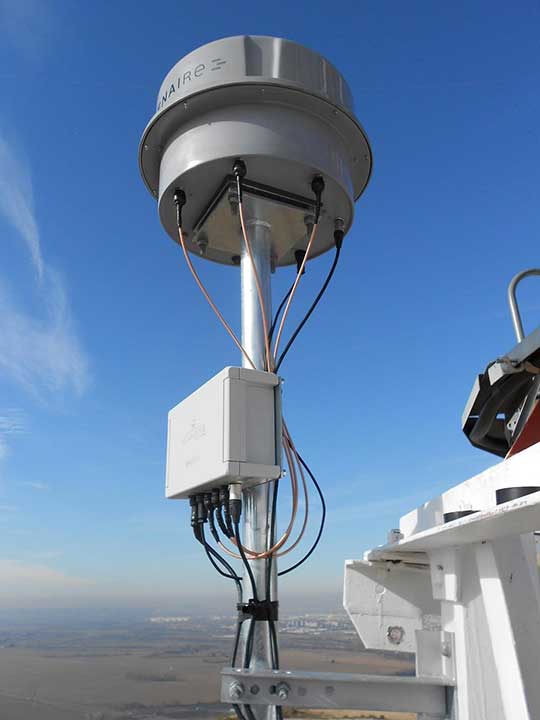
An ENAIRE GNSS RFI monitor close to the Madrid-Barajas Airport in Madrid, Spain. (Photo: ENAIRE)
The received power of GPS and Galileo navigation signals at the antenna output of a user receiver is typically extremely small, from approximately –165 up to –150 dBW, which makes them inherently vulnerable to radio-frequency interference (RFI) caused by the emissions of other radio systems. This interference is often unintentional, such as from malfunctioning or spurious emission from a transmitter in the vicinity of the GNSS receiver.
However, we have seen numerous reports about the deliberate jamming of GNSS signals. The most frequent examples of such interference reports are caused by so-called personal privacy devices (PPDs) — low-power GNSS jammers used to locally disable the operation of GNSS receivers. Although the use of PPDs is illegal, they can be easily acquired on the internet. A $10 jammer with 100 mW of transmitter power is enough to degrade performance or disrupt GNSS receivers in a range of 10–100 meters. In the past decade, more complex and powerful jammers have also become available, along with spoofers — devices that create GNSS-like signals that fool receivers to provide false location or time solutions. A $100 software-defined radio bought online can be used as a spoofer.
ENAIRE (the Spanish air navigation service provider) conducted an international survey and associated analysis of GNSS RFI detection and localization systems. The survey was part of the EU–U.S. Working Group C Sept. 2017–Sept. 2019 Work Plan, with contributions of the European Commission (DG DEFIS), the German Aerospace Center (DLR), the U.S. Federal Aviation Administration (FAA), Eurocontrol, the MITRE Corporation and Stanford University. Working Group C promotes cooperation between the U.S. and EU on design and development of the next generation of civil satellite-based navigation and timing systems. The survey was conducted within the Resilience Subgroup focused on counteractions required in view of growing concerns over jamming and spoofing threats.
Manufacturers and Users
The survey was provided in two versions: one targeted to manufacturers and another to the users of interference detection systems. The two surveys were implemented online July 12–Oct. 26, 2018. There were 23 responses: 11 from manufacturers and 12 from users (see Acknowledgments below for companies that participated). Regarding the manufacturers’ responses, the nine surveyed companies represent about 50% of the market of RFI monitoring products available in 2018.
RFI Equipment Used
We present here the aggregated results of the RFI equipment manufactured and used by the participating entities.
Frequency Bands and Signals. The L1/E1 band is covered by all of the manufacturers’ and users’ surveyed products. L5/E5a and other bands are monitored in only 42% of the cases, or even less. Most RFI systems demodulate or analyze the GPS L1 C/A signal. Only 8% and 17% of users analyze GPS L5 and Galileo E5a, respectively.
Capabilities. 55% of the industry, and 25% of the users’ surveyed products, provide RFI localization capabilities, while 45% of the industry, and only 33% of the users’ surveyed products, detect some type of spoofing.
Power and Antenna Gain. Most of the systems achieve a sensitivity better than or equal to –120 dBm, meeting the International Civil Aviation Organization requirement for GPS and SBAS L1 airborne receivers to withstand interference (–120.5 dBm CW, in-band) after steady-state navigation has been established. The gain of antennas used in RFI detection systems ranges from 2 dBi up to 45 dBi.
Real-Time Bandwidth. The maximum real-time monitored bandwidth of the surveyed products ranges from 16 MHz up to 60 MHz in L1. Most of the products monitor a 20-MHz bandwidth (similar to the GPS L1 C/A reference bandwidth for pre-GPS III satellites, which is 20.46 MHz).
Spectrum Refresh Time. The time needed by the RFI detector to capture and process a plot of the RF spectrum in a specific band to look for interference signals ranges from 1 microsecond to 2 seconds.
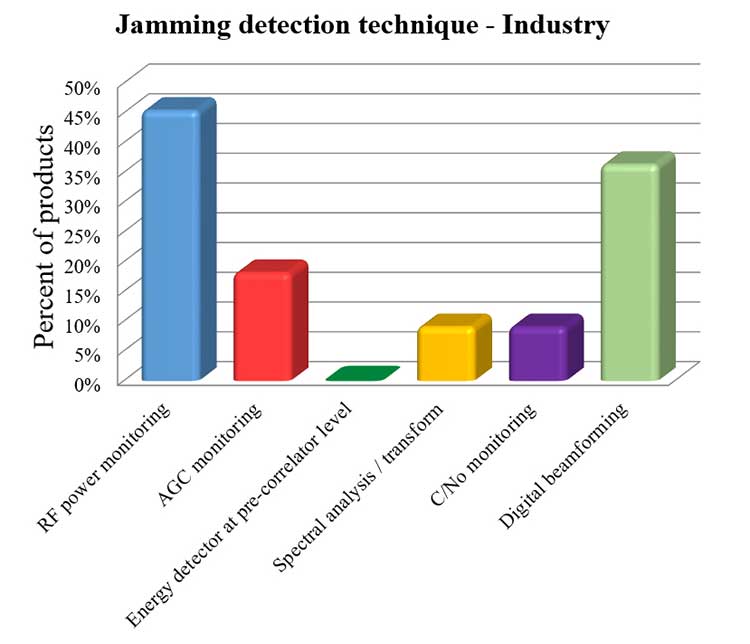
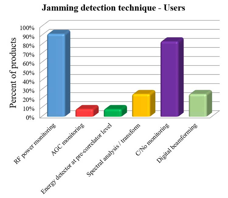
Jamming Detection Techniques. The most widespread jamming detection technique is RF power monitoring (45% industry, 92% users), followed by digital beamforming (CRPAs), carrier-to-noise-density ratio (C/N0) monitoring and spectral analysis/transforms (see Figure 1). Note that RF power monitoring and automatic gain control (AGC) monitoring are in essence the same detection technique: AGC voltage levels — after calibration with a reference RF generator — can be converted into RF input power levels.
Figure 1a. Jamming detection techniques used by industry. (Chart: RFI survey)Figure 1b. Jamming detection techniques of users. (Chart: RFI survey)
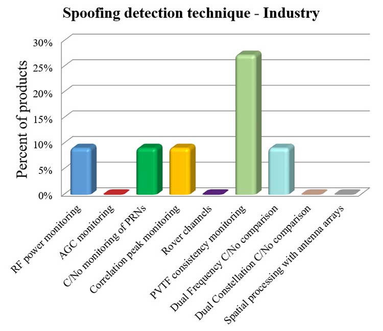
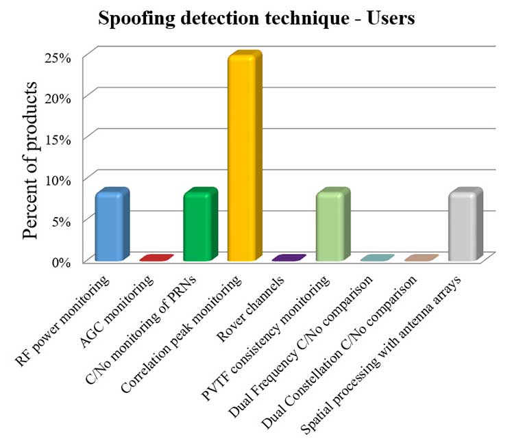
Spoofing Detection Techniques. The most widespread spoofing detection techniques are PVTF consistency monitoring (industry products, 27%) and correlation peak monitoring (users, 25%), followed by digital beamforming (CRPAs), C/N0 monitoring and spectral analysis/transforms (see Figure 2).
Figure 2a. Spoofing detection techniques used by industry. (Chart: RFI survey)Figure 2b. Spoofing detection techniques of users.(Chart: RFI survey)
Localization. The most widespread RFI localization technique is direction/angle of arrival (DOA/AOA): 55% in industry products and 25% in users’ systems. AOA techniques used are correlative interferometer (phase-difference), Watson-Watt (amplitude-difference) and array signal processing. The AOA accuracy of surveyed products ranges from ±3° to ±10°.
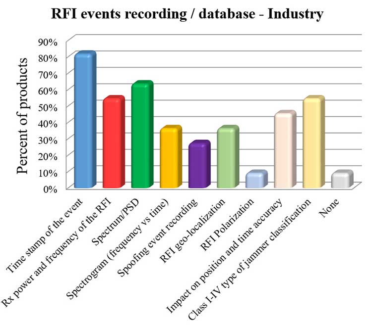
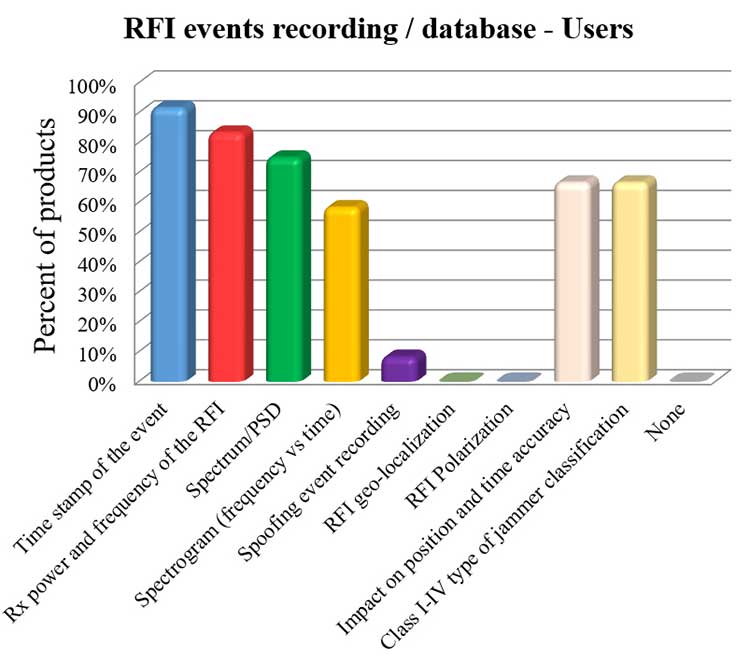
Event Recording. For an interference event, most products record the time stamp, received power, central frequency, frequency spectrum, the spectrogram (frequency versus time plot) and the jammer type. Only 8% of surveyed users perform spoofing event recording (see Figure 3). 92% of users record RFI/spoofing events; half also report them to their national spectrum administration. Users have from one to 11 jammer detectors. Only four users have been registered with spoofing detectors, each using one.
Figure 3a. RFI events recording/database used by industry. Jammer classifications: Class I — continuous wave signal; Class II — chirp signal with one saw-tooth function; Class III — chirp signal with multi saw-tooth functions; Class IV — chirp signal with frequency bursts. (Chart: RFI survey)Figure 3b. RFI events recording/database of users. Jammer classifications: Class I — continuous wave signal; Class II — chirp signal with one saw-tooth function; Class III — chirp signal with multi saw-tooth functions; Class IV — chirp signal with frequency bursts. (Chart: RFI survey)
Event Sharing. 75% of surveyed users are willing to collaborate in the creation of an international RFI and spoofing events common database, but the remaining 25% explicitly do not want to share their databases.
Future RFI Monitoring Equipment
Based on the analysis of the aggregated results from the survey, we identified some recommendations for improving RFI monitoring:
L5/E5a band. To be ready for introduction of the L5/E5a band into aviation operational use (expected by 2025), it is suggested that aviation organizations increase efforts to monitor and analyze the RFI situation in the L5/E5a band.
Spoofing detection. National organizations in charge of critical infrastructures should increase their efforts to detect spoofing (at least at the same level as jamming detection). Multi-constellation and dual-frequency spoofing detection should be promoted (not only L1/E1 spoofing).
GNSS RFI monitoring with enough bandwidth: The maximum real-time monitored bandwidth of the surveyed products ranges from 16 MHz to 60 MHz, while most of the products monitor only a 20-MHz bandwidth. The receiver reference bandwidth for E1 is 24.552 MHz, while for L1 GPS III it is 30.69 MHz. U.S.-EU GNSS RFI detection systems for critical infrastructures should be designed to monitor at least 31 MHz of bandwidth in the L1/E1 band, with 50 MHz recommended to cope with typical –3 dB bandwidth of pre-low-noise-amplifier (LNA) GNSS L1/E1 receiver filter. The same rule should be applied to other GNSS bands. Even more bandwidth for monitoring could be needed to cope with rare interferers, such as a high-power source, whether intentional or unintentional, radiating in near-band L1/E1 but not in the passband frequencies, bypassing the rejection of the receiver’s filters and degrading the GNSS signal reception.
Air Navigation
In the EU, performance-based navigation (PBN) will become the norm in all flight phases, and GNSS (with or without SBAS) will be the main position source, by June 2030. A similar scenario is being developed in the U.S. Conventional procedures and ground-based navigation aids will be used only in contingency situations. GNSS RFI can degrade the current GBAS CAT I (GAST-C) service in airports and could jeopardize safe operation of upcoming GBAS CAT II-III (GAST-D) service. GNSS also is the key enabler for ADS-B.
Therefore, it is critical for air transportation to improve its capability to detect radio frequency interference to GNSS and mitigate its harmful effects, both on the ground and in the air.
Ground Detection and Localization. These systems should be installed at and around all airports. ENAIRE has recently deployed an AOA RFI detection and localization system around the Madrid airport called DYLEMA. It consists of nine AOA RFI and spoofing detectors, two spoofing-only detectors, an IP communication network and a GNSS monitoring center operated 24/7. From this center, ENAIRE will report RFI events to the Spanish spectrum agency. Similar systems will be deployed in other large Spanish airports in the next years. In small airports, ENAIRE is deploying single-unit RFI detectors (one detector per airport, currently without the AOA feature). These systems are complemented by handheld and airborne spectrum analyzers equipped with directional antennas and RFI AOA features, used if an RFI event of high power or duration takes place.
Airborne Detection and Localization. Several initiatives are under study or initial design for airborne detection and localization systems, using current avionics receivers with no hardware modification or new hardware such as additional antennas in the aircraft. Future airborne RFI detection systems should include indoor coverage to detect jammers and spoofers in the airplane itself. EUROCONTROL is leading one of these initiatives using ADS-B. Given a reliable ADS-B data feed with suitable coverage information, a search algorithm could scan for outages. If the data is dense enough, it is possible to locate the source, even if the GNSS airborne antenna is omnidirectional with no AOA features. Another commercial initiative, GATEMAN, uses new GNSS antennas and components to provide AOA detection and localization features.
UAV-Embedded Detection and Localization. Detection and localization systems embedded in UAVs are not widely commercially available, but they will be useful to complement fixed or ground RFI monitoring systems, especially to detect fast moving mobile jammers and spoofers. A jammer moving at high speed could be found by a fixed detector, trigger the UAV take-off (collocated with the detector or close to it), and start tracking the target. If equipped with a camera, it could identify the vehicle carrying the jammer or spoofer. Such a system has to function in GNSS-denied scenarios, and needs to use sensors other than GNSS. Stanford University has recently developed a prototype of such a system.
Other Sectors
Shipping. RFI detection systems should be installed at and around harbors, where positioning requirements are the most stringent. Mobile AOA detectors can be installed in vessels. A DLR experiment integrated its GALANT GNSS RFI detector on a ship sailing from Spain to South Korea and back.
Railroads. Detection and localization systems should be installed at train stations and main railway junctions or switches. It is possible to install mobile detectors in trains to detect jammers inside the train apart from outdoor coverage to detect jammers outside the train.
Roads. Most PPD jammers in use are on roadways. Jammers not only jeopardize aviation and timing systems; they can jeopardize the safety of the coming autonomous road vehicles. We strongly recommend that police and road surveillance systems include jammers and spoofers as a daily target, to detect, localize and punish their users.
Supporting proposals include installing fixed detectors at tollbooths, road gantries or other points near roads; and using mobile detectors — for example, on police vehicles for locating a car that carries a jammer. Public transport services with enough vehicles (such as taxis or busses) could also detect RFI.
Smartphone Platforms. Initiatives are using smartphone crowdsourcing platforms to detect interference based on C/N0 or AGC measurements. At this time, only prototype apps for Android phones are available. The Apple iOS does not allow access to GNSS raw data. Android applications can include localization capabilities based on Time Difference Of Arrival (TDOA) or Power Difference Of Arrival (PDOA). Having a detection system in a mass-market product would create millions of detectors around the world. Reward programs by national or local administrations would encourage use of the app. User consent to obtain the data will be needed.
Space-Based Detection. Space-based detection is feasible to find medium- to high-power jammers and spoofers. Several projects have performed simulations, such as the ground to space threat simulator from Qascom and Spirent Communications. In this project, simulations achieved an error of less than 1.5 km using a medium-Earth-orbit (MEO) satellite as the RFI sensor and a 20-dBm static jammer on Earth, with 15 minutes of observation time. Also, an experimental program from the International Space Station has demonstrated that RFI can be detected from low Earth orbit.
The main issue of such detection systems is the cost to deploy all the satellites needed to have a global coverage with a low response time (2 hours or less to detect RFI). The performance of a space-based RFI system is better when using a LEO constellation (as, compared to an MEO system, it detects RFI with a lower transmitted power). One such system by HawkEye 360 was deployed in 2019. The company plans to operate a fleet of 30 satellites in LEO orbit, enabling it to gather new signals from any point on the planet within 30 to 45 minutes.
General Recommendations
Increased Effort Needed. Public administrations and transport service providers should increase their efforts to deploy GNSS RFI detection and localization systems. In parallel, governments should punish individuals or organizations using jammers or other types of illegal transmitters or emissions. Jamming and spoofing is illegal in the EU and the U.S. An increased RFI monitoring effort should be coordinated at the national or regional level to find synergies and avoid duplications.
Planned Interference. Government agencies, including national radiofrequency spectrum agencies, should coordinate nationally and internationally with air, rail, road, maritime and other critical infrastructure entities before any planned intentional interference is conducted, such as military exercises or protection of special events from potential terrorist attack. This coordination includes an analysis of the estimated area and airspace volume affected by the RFI, the associated notification to the GNSS users before and during the RFI radiation period (such as a NOTAM, Notice to Airmen), as well as the indication to use established alternative procedures (non-GNSS).
A Common Database. The creation of an international common database of GNSS RFI events could boost the fight against GNSS RFI. A specific action could define a standard of the RFI data format to be registered and shared in an international database, including a possible RFI classification (also defined and agreed to as part of the standard). One initiative related to the creation of an international GNSS RFI threats database was proposed by the EU-funded STRIKE 3 project in 2017.
Acknowledgments
The work presented in this report has been performed under the U.S.-EU Agreement on GPS-Galileo Cooperation, Working Group C, Resiliency Subgroup. The authors thank the participants of the Working Group and the Resiliency Subgroup — in particular, Eurocontrol and the FAA for distribution of the survey in the EU and the U.S., respectively. The authors also thank the organizations that participated in the survey: Spirent Communications, GMV, Centum Solutions, THALES, IDS AirNav, Chronos Technology, Innovationszentrum für Telekommunikationstechnik (IZT), Collins Aerospace, German Aerospace Center (DLR), Netherlands Aerospace Centre (NLR), Deutsche Flugsicherung (DFS), Direction des Services de la Navigation Aérienne (DSNA), Polish Air Navigation Services Agency (PANSA), Belgocontrol, ENAV and ENAIRE.
José Luis Madrid-Cobos is the technical manager of GNSS interference detection and localization systems at ENAIRE, the Air Navigation Service Provider in Spain. Ana Bodero-Alonso is the head of the Satellite Navigation Department at ENAIRE. Ignacio Fernández-Hernández is responsible for Galileo high accuracy and authentication at the European Commission. Eric Châtre is the head of the GNSS Exploitation and Evolutions Sector at the European Commission. Andriy Konovaltsev is a research assistant at Institute of Communications and Navigation of the German Aerospace Center (DLR). Christopher Hegarty is a technical fellow with The MITRE Corporation.