Blog

  • NASA hosts next national space-based PNT advisory board meeting

    NASA hosts next national space-based PNT advisory board meeting

    Logo: NASA

    NASA will be hosting the national space-based PNT advisory board meeting on July 1. The meeting will be held virtually, rather than in-person, 11 a.m. to 3 p.m. Eastern Time.

    NASA sponsors the advisory board on behalf of the National Executive Committee for Space-Based PNT. Advisory board members are nominated by the agencies of the National Executive Committee and appointed by the NASA administrator.

    According to NASA, this meeting will be formally called the “24th Interim Meeting” in preparation for the 25th meeting in the fall of 2020.

    The meeting will cover a number of topics, including:

    • Updates on emerging U.S. PNT policies;
    • the status of GPS constellation services and modernization;
    • techniques to protect, toughen and augment to GPS/GNSS services for multiple user sectors;
    • alternative or complimentary PNT signals sources to GPS/GNSS signals in a stressed spectrum environment;
    • opportunities for enhancing the interoperability of GPS with other emerging international GNSS constellations; and
    • emerging trends and requirements for new PNT services in U.S. and international fora.

    Those participating must use a touch-tone phone. Any interested person may dial the USA toll-free conference call number 1-844-467-4685 or toll number 1-720-259-7012, passcode 106724, to participate in this meeting by telephone.

    The WebEx link is https://nasaenterprise.webex.com/; the meeting number is 198 621 2282, and the password is GCsKMAd?334.

    For more information, contact James J. Miller, Designated Federal Officer, Human Exploration and Operations Mission Directorate, NASA Headquarters, Washington, DC 20546, (202) 358-4417, fax (202) 358-4297, or [email protected].

  • SBG Systems advances GNSS/INS with 3rd-generation Ellipse

    SBG Systems advances GNSS/INS with 3rd-generation Ellipse

    Photo: SGB Systems
    Photo: SGB Systems

    SBG Systems renews its popular line of miniature inertial sensors with high-end functionalities and dual frequency RTK

    SBG Systems has announced the third generation of its Ellipse series of miniature inertial sensors. The renewed product line benefits from a 64-bit architecture, allowing high precision signal processing.

    All of the INS/GNSS devices now embed a dual-frequency, quad constellations GNSS receiver for centimetric position and higher orientation accuracy.

    SBG Systems manufactures miniature high-accuracy inertial navigation systems with inertial measurement unit (IMU) design, calibration and filtering. All improvements made in the high-end lines could naturally benefit the Ellipse miniature line.

    The Ellipse series includes four models.

    • Ellipse-A is a motion sensor
    • Ellipse-E provides navigation with an external GNSS receiver
    • Ellipse-N is a single-antenna RTK GNSS/INS
    • Ellipse-D is a dual-antenna RTK GNSS/INS

    With its new 64-bit architecture, the third-generation Ellipse series enables the use of high-precision algorithms and technology used in high-end inertial systems such as rejection filters and FIR filtering.

    All Ellipse miniature INS are now RTK-enabled without extra cost, and output raw data for post-processing. All these features are made possible in a small, robust aluminum-enclosure box version, as well as in the 17-gram OEM version.

    The 17-gram OEM version of the Ellipse-D can provide drones with high-end features. Its dual antennas gives UAVs robust instant heading for take-off. Dual antenna is achievable with a very short baseline, down to 50 centimeters. Integration is enabled with ROS and PX4 drivers, full API, and free phone and email technical support.

    Ellipse-D

    Ellipse-D is the smallest dual-frequency, dual-antenna RTK GNSS/INS device offered.

    With its dual-frequency RTK GNSS receiver, the Ellipse-D provides a centimeter positioning. Dual frequency provides more robust heading and position computation than single-frequency receivers. It also allows high performance in attitude (0.05°) and in heading (0.2°).

    With its dual-antenna capability, Ellipse-D provides precise heading in a few seconds, in all dynamic conditions, and even in challenging GNSS conditions. It is also immune to magnetic disturbances. Ellipse-D is a quad-constellation receiver, simultaneously using signals from GPS, GLONASS, BeiDou and Galileo to enable navigation in challenging conditions.

    Designed with high quality industrial-grade components, Ellipse inertial sensors are highly tested and calibrated in dynamic and temperature for consistent, repeatable behavior in all conditions.

  • New Septentrio receiver integrates correction service

    New Septentrio receiver integrates correction service

    Photo: Septentrio
    Photo: Septentrio

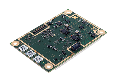
    Septentrio has unveiled the AsteRx-m2 Sx OEM board, which provides a GPS/GNSS receiver with always-on sub-decimeter accuracy without the need for additional correction service subscriptions.

    With the AsteRx-m2 Sx, Septentrio is pioneering a novel approach to high-accuracy positioning. Its latest core GNSS technology is integrated with a sub-decimeter correction service enabling simple plug-and-play positioning solutions.

    High-accuracy positioning is available directly out of the box as GNSS corrections are automatically streamed to the receiver. This significantly simplifies the receiver set-up process and eliminates the hassle of corrections service subscription and maintenance.

    “This product marks a new step for GNSS technology towards convenience and ease-of-use,” said Danilo Sabbatini, product manager at Septentrio. “By integrating the correction service directly into the GNSS receiver, we are removing the hassle of positioning service set-up and maintenance from the user. This means faster set-up times for our customers and worry-free, always-on high-accuracy positioning throughout the receiver lifetime.”

    The AsteRx-m2 Sx is an efficient positioning solution for small robots, aerial drones and automation applications. Its optimized size, weight and power (SWaP) means longer operation on a single battery charge and better value in the field, according to Septentrio.

    Advanced anti-jamming technology AIM+ ensures robust and reliable operation in challenging environments, even in the presence of RF interference.

    Septentrio is offering a free GNSS corrections webinar on July 8 at  5 p.m. CEST/ 8 p.m. PST.

  • URISA accepting applications for Vanguard Cabinet

    Logo: URISA Vanguard Cabinet

    The Urban and Regional Information Systems Association (URISA) is now accepting applications for its Vanguard Cabinet.

    The Vanguard Cabinet is an advisory board made up of passionate, young geospatial professionals who strive to engage young practitioners, increase their numbers in the organization and better understand the concerns facing these future leaders of the geospatial community. The board consists of members that are 35 years of age or younger.

    The cabinet’s mission is to collaborate with URISA’s board of directors and URISA committees in creating and promoting programs and policies that will benefit young professionals, as well as enhance overall innovation, collaboration, networking and professional development opportunities.

    Cabinet members are selected through an application process, with a review by the URISA Leadership Development Committee. Those who apply must submit a letter of reference from a colleague, supervisor, mentor or instructor; a resumé; and a completed online application form.

    The application process will close on July 20.

  • How aerial imagery helps protect natural resources

    How aerial imagery helps protect natural resources

    Photo: Lake County Forest Preserves
    Photo: Lake County Forest Preserves

    An upcoming GPS World webinar shows how high-definition aerial imagery can help protect and maintain natural resources.

    In Transforming Land and Asset Management with HD Aerial Imagery, four
    mapping experts discuss how Lake County Forest Preserves of Illinois uses HD aerial imagery to manage and track changes.

    The webinar, sponsored by Nearmap, takes place June 25 at 1 p.m. EDT / 10 a.m. PDT / 7 p.m. (1900h) Central European Time. Registration is free.

    Managing and protecting the nearly 31,000 acres of the preserves is no small task, so the ability to see the environment at scale in crystal-clear clarity is a must. Aerial imagery provides an “eye in the sky” to get better context of truth on the ground.

    Lake County Forest Preserves uses Nearmap aerial imagery to:

    • monitor and track change over time with historical and current captures
    • assess and address invasive species growth with high-resolution imagery
    • manage remote work challenges during COVID-19 to locate assets.

    Joining Brett Clark of Nearmap are three experts from Lake County Forest Preserves.

    Nick SpittlemeisterNick Spittlemeister
    GIS Analyst, Planning and Land Preservation Dept.
    Lake County Forest Preserves District (IL)

    Nick Spittlemeister has been with Lake County Forest Preserves since 2016, working to create an enterprise solution that employs web GIS in all facets of the organization. He helped the district secure a license with Nearmap in 2018 and has deployed it across their GIS system, from Desktop software to web applications and native apps. He has been using GIS for more than 15 years and holds a bachelor’s degree in geography from Northern Michigan University.

    Dave CassinDave Cassin
    Manager of Landscape Ecology
    Lake County Forest Preserves District (IL)

    David Cassin’s remote sensing training began in the US Navy (1990-94) where he was trained as an Intelligence Specialist / Air Photo Interpreter, put into practice during Operation Desert Shield / Storm. Post military service, he continued his craft in college with incorporation of ArcGIS. He combined his skillset and his love of nature by getting a degree in Natural Resource Management. Integrating remote sensing skills into landscape scale restoration projects by utilizing historical air photos and land survey data, he is able to determine historic land uses and alterations. Specific to Nearmap, he was able to map populations of Phragmites australis (an invasive species in Illinois) by utilizing the fall 2019 Nearmap imagery remotely during the COVID-19 stay at home order.

    Kevin KleinjanKevin Kleinjan
    Senior Engineer
    Lake County Forest Preserves District (IL)

    Kevin has utilized aerial imagery and geospatial technologies for over 25 years to inform and support planning and infrastructure related decisions. He utilizes Nearmap’s high-resolution imagery with multiple captures throughout a calendar year to analyze and update infrastructure assets quickly and accurately from both the office, and in the field using mobile devices. This enables him to efficiently manage the District’s sign shop, site amenity and heavy equipment crews. He has dual degree in Landscape Architecture and Geography from South Dakota State University and is a Registered Landscape Architect in Illinois and Wisconsin.

    Brett Clark

    Brett Clark
    Senior Account Executive
    Nearmap
    Brett graduated from Brigham Young University with a degree in communications. He was employee #2 for Nearmap, U.S., and focuses primarily on serving the public sector – both state and local. Brett lives in the Indianapolis area with his wife and three daughters.

    Register for the free webinar here.

  • HoverGames competition uses NXP tech to fight pandemics

    HoverGames competition uses NXP tech to fight pandemics

    The robotics competition challenges participants to leverage NXP’s portfolio for small autonomous vehicles in support of fighting pandemics.

    NXP Semiconductors N.V. is hosting a challenge on using drones and rovers for pandemics such as COVID-19.

    HoverGames Challenge 2: Help Drones Help Others is the second installment of NXP’s challenge-based, interactive coding competition. It encourages developers to create drone and rover solutions for frontline support during pandemics.

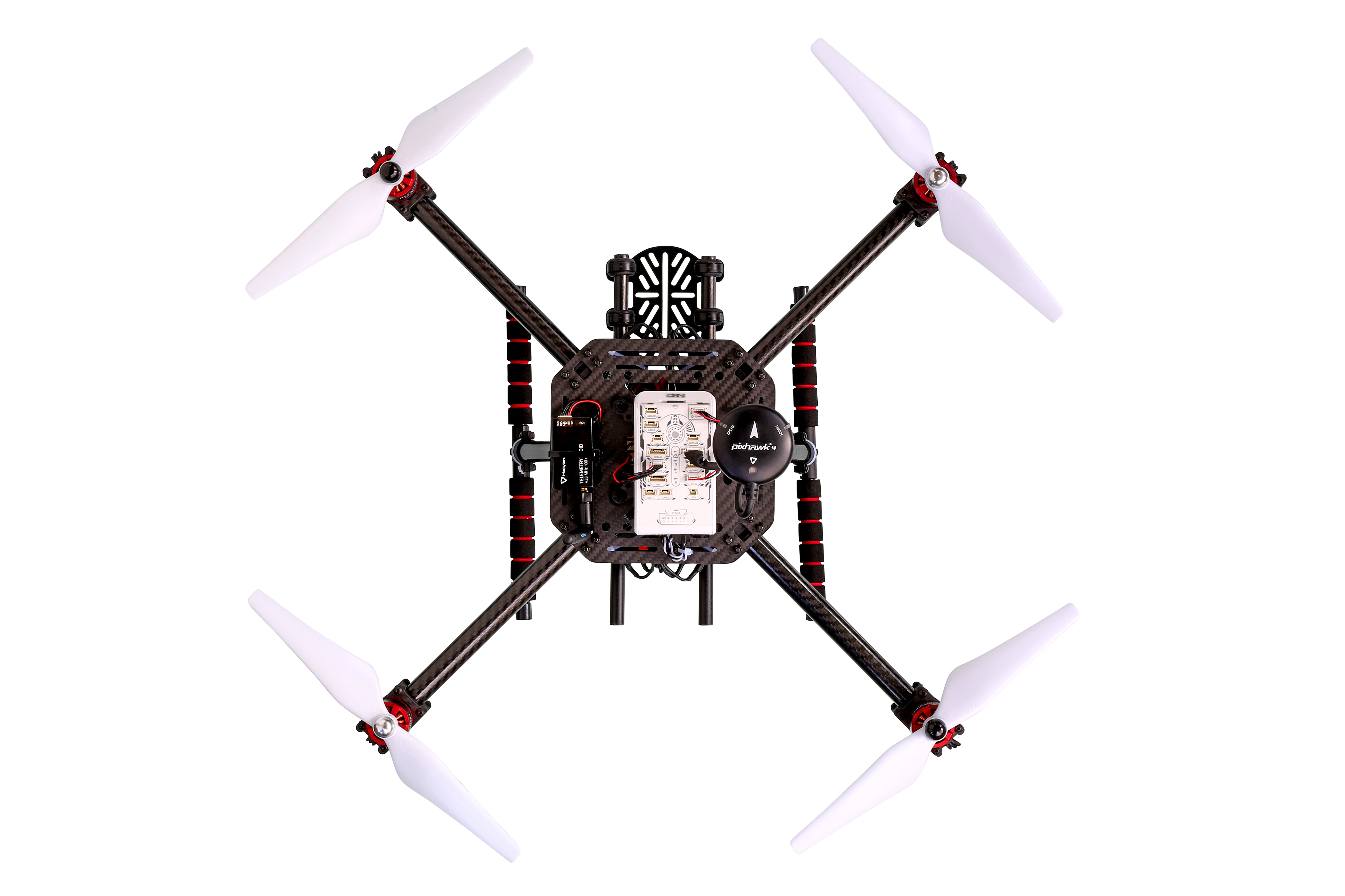
    A carbon-fiber quadcopter frame is included in the developer's kit. (Photo: NXP)
    A carbon-fiber quadcopter frame is included in the developer’s kit. (Photo: NXP)

    Participants will leverage NXP’s broad portfolio of automotive, industrial and IoT technologies for system control, networking, security and motor control to create solutions that can make a difference in pandemic response.

    The first HoverGames took place in the summer of 2019, and was centered around firefighter response. Read about it here.

    The collateral effects of pandemics leave citizens with difficult challenges to overcome. A lack of mobility, social isolation and lack of access to goods and services can be physically and psychologically devastating.

    HoverGames Challenge 2 will inspire participants to develop pioneering ways to use drones to help healthcare and frontline workers overcome these barriers. The competition encourages contestants to consider the full scope of the difficulties facing society during a pandemic, apply new learning, and work cooperatively through the development of open-source code and community-tested projects to create solutions that help society prepare for future challenges.

    Deadline for application is July 31. The competition closes Nov. 30, and winners will be announced in December.

    Drone Developer Kit. The hardware and software of this year’s developer kit remains open, flexible and modular. The flight management unit (RDDRONE-FMUK44FMU) includes professional, automotive and industrial-grade components enabled by the PX4 flight stack. PX4 is a large commercially deployed open source flight stack and supports contemporary airframe architectures including vertical-takeoff-and-landing (VTOL) aircraft, multicopter and rover profile.

    The kit also includes a strong, rigid, lightweight carbon-fiber quadcopter frame with platform, mounting rails, landing gear, motor controllers, motors and props as well as telemetry radio and remote-control radio.

    This year’s kit will contain a bonus extension component, the NavQ, an i.MX8M Mini Vision development board.

    Projects and lessons learned are transferable to real-world enterprise and commercial applications thanks to Auterion, the company that builds the enterprise distribution of PX4 for the commercial drone market.

    “The current pandemic has exposed our vulnerability to disease and the general structural breakdown that can occur during a crisis,” said Iain Galloway, drone program lead, Systems Innovation, NXP. “But we don’t have to feel powerless in its wake. We can harness technology to make a difference. We invite you to leverage a complete functional system of hardware and software for drone and rover development and to share your creative solutions.”

  • GMV’s navigation system chosen for Spain’s new F-110 frigates

    GMV’s navigation system chosen for Spain’s new F-110 frigates

    The F-110 frigate being developed for the Spanish Navy. (Artist's concept: Spanish Ministry of Defense)
    The F-110 frigate being developed for the Spanish Navy. (Artist’s concept: Spanish Ministry of Defense)

    The technology multinational GMV has signed a contract with Spanish corporation Navantia to develop and supply its SENDA navigation system for the future F-110 frigates.

    The F-110 frigates represent a technological leap forward in platform systems and its combat system, incorporating Industry 4.0 technologies to improve lifecycle-long system management.

    The various F-110 systems call for a continuous, precise, and trustworthy positioning, speed and attitude source. With this purpose in mind, SENDA incorporates multi-constellation (GPS and Galileo) satellite navigation technology compatible with both civil and military signals, plus differential GNSS corrections. It combines its GNSS navigation data with data received from external sensors, such as inertial navigation systems (INS) and pitometer logs. It includes state-of-the-art algorithms to provide robust navigation in contested GNSS scenarios.

    SENDA also includes a timing server that generates highly precise and stable timing signals, allowing the ship’s systems to synchronize with GPS time. SENDA guarantees timing-reference stability and negligible drift, even during prolonged periods of GPS downtime.

    SENDA is a redundant system with two complete functional subsystems working in active-active configuration, together with redundant GNSS signal distribution. Both systems, monitored in real time, exchange information to provide the overall system with the best possible solution.

    GMV has experience in aeronautics, land and naval sectors with platforms such as the Atlante tactical long-endurance UAV, the 8×8 Dragon ground vehicle and now the F-110 frigates.

    GMV worked with the Spanish Ministry of Defense MoD to develop a system prototype during the F-110 definition phase. The future F-110 frigates will replace the current Santa María class frigates starting in 2026.

  • Qualcomm launches 5G, AI-enabled robotics platform

    Qualcomm launches 5G, AI-enabled robotics platform

    The Qualcomm Robotics RB5 Development Kit (Photo: Qualcomm Technologies)
    The Qualcomm Robotics RB5 Development Kit (Photo: Qualcomm Technologies)

    Qualcomm Technologies released the Qualcomm Robotics RB5 platform. The RB5, comprised of hardware, software and development tools, is designed for the consumer, enterprise, defense, industrial and professional service sectors.

    According to the company, the platform’s Qualcomm QRB5165 processor offers a heterogeneous computing architecture, coupled with the fifth-generation Qualcomm AI Engine that delivers 15 tera operations per second of artificial intelligence (AI) performance for running complex AI and deep learning workloads. The processor also offers incredible machine learning inferencing at the edge under restricted power budgets using the new Qualcomm Hexagon Tensor Accelerator.

    Technical features of the RB5 include heterogeneous computing capabilities, 5th generation Qualcomm AI engine, advanced imaging capability, security support and connectivity. Qualcomm’s Spectra 480 Image Signal Processor (ISP) captures fast, professional-quality photos and videos, and can process two gigapixels per second, the company said.

    In addition, seven concurrent cameras facilitate simultaneous localization and mapping (SLAM), object detection and classification, autonomous navigation and path planning to perform tasks in indoor and outdoor settings.

    With the Qualcomm Robotics RB5 platform and the Qualcomm QRB5165 processor, Qualcomm enables various design offerings including off-the-shelf system-on-module solutions and flexible chip-on-board designs, the company said. The solution is available in multiple options, including commercial and industrial-grade temperature ranges and an option for extended lifecycle until 2029.

    “With the Qualcomm Robotics RB5 platform, Qualcomm Technologies will help accelerate growth in a wide array of robotics segments such as autonomous mobile robots, delivery, inspection, inventory, industrial, collaborative robots and unmanned aerial vehicles, enabling Industry 4.0 robotics use cases, and laying the foundation for the UAV Traffic Management space,” said Dev Singh, senior director, business development and head of autonomous robotics, drones and intelligent machines at Qualcomm.

    Qualcomm also has entered into a strategic collaboration with TDK to further enhance the capabilities of the Qualcomm Robotics RB5 platform. Through the partnership, TDK added its latest sensor technologies for enhanced robotics applications as part of the Qualcomm Robotics RB5 platform.

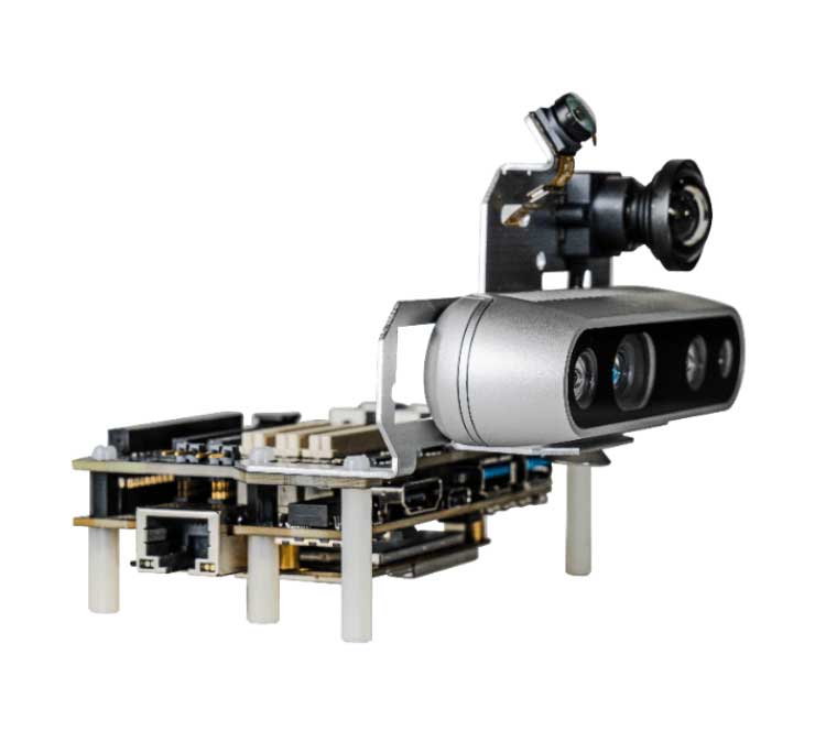
    The Qualcomm Robotics RB5 Development Kit

    In addition, Qualcomm Robotics RB5 Development Kit ensure developers have the customization and flexibility they need to make their visions a commercial reality.

    According to Qualcomm, the kit allows developers to have flexible software capabilities, with the platform offering support for Linux, Ubuntu and Robot Operating System 2.0, as well as pre-integrated drivers for various cameras, sensors and 5G connectivity. It also provides support for OpenCL, OpenGLES and OpenCV.

    It also includes support for the Intel RealSense Depth Camera D435i and Panasonic TOF Camera to provide depth-sensing capabilities. TDK’s six-axis ICM-42688-P IMU, ICP-10111 barometric pressure and T5818 Digital bottom port microphone are integrated into the kit, as well.

  • Orolia awarded US defense contract for advanced GPS simulation Suite

    Orolia awarded US defense contract for advanced GPS simulation Suite

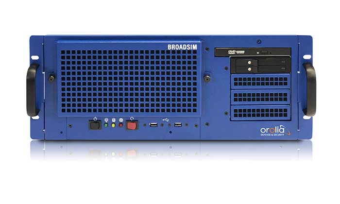
    The U.S. military selected Orolia Defense and Security to supply multiple BroadSim advanced GPS simulator systems, a contract valued at $1.7 million (USD), in an effort to upgrade testing facilities and field test assets.

    The BroadSim Advanced GNSS Simulator (Photo: Orolia)
    The BroadSim Advanced GNSS Simulator (Photo: Orolia)

    These new simulator systems will enable better testing of widely deployed military GPS receivers, which are integrated into air and ground-based positioning, navigation and timing (PNT) systems.

    BroadSim will be leveraged with Orolia’s Panacea test suite, which the U.S. military uses to conduct automated testing and analysis for PNT system performance and vulnerabilities.

    BroadSim will bring versatility to the testing process by supporting diverse test methods and environments such as a laboratory setting, or an over-the-air (OTA) field test event.

    BroadSim was selected based on its flexibility to support the ever-changing military tasks at hand, according to Orolia. It can be easily configured to support laboratory testing one day, and field testing the next with its four independent RF outputs, removable drives, and software-defined architecture.

    “Equipping our actively deployed warfighters with state-of-the-art technology is of utmost importance and can mean the difference between mission success and failure. To help achieve that goal, Orolia’s GPS testing and simulation solutions ensure that these systems are battlefield ready,” said Tyler Hohman, Orolia Defense and Security’s director of products.

    The U.S. military and other federal agencies such as DHS host several test events per year in which industry participates, such as GPS Testing for Critical Infrastructure (GET-CI).

    Orolia will host a webinar on this topic on Thursday, July 16, at 2 p.m. EDT, titled “PNT Vulnerability Testing for Critical Infrastructure:Lessons Learned from Defense.”

    The federal government considers PNT to be a critical aspect of mission success, as outlined in the C4ISRNET white paper “Protecting the U.S. Military PNT Advantage from GPS Jamming and Spoofing” and defined in the PNT Executive Order. For the 2021 federal fiscal year, the U.S. Army alone budgeted more than $275 million towards Assured PNT Research, Development, Test & Evaluation (RDT&E), as published in the 2021 Defense Budget.

  • Thank you for registering.

    Thank you for registering for the upcoming webinar, “Transforming Land and Asset Management with HD Aerial Imagery” sponsored by Nearmap Inc..

    A link to the live event will be sent to you two hours before the event. Your personalized event URL will be automatically generated by the ON24 system. To ensure receipt of the email, please whitelist this email address by adding it to your contacts: [email protected].

    This presentation will begin at 1 p.m. Eastern / 10 a.m. Pacific on Thursday, June 25th. A recording will also be sent to you the following day so you can watch it on-demand.

    Audience members may arrive 15 minutes prior to live time. If you have any questions, please contact event producer Grace Rybak at [email protected]

  • Optical Zonu offers ‘GPS at the Edge’ for 4G/5G small cell deployments

    Optical Zonu offers ‘GPS at the Edge’ for 4G/5G small cell deployments

    The huge current investment in deploying 5G mobile networks is promoted by setting high expectations for significantly increased throughput and reduced latency.

    This can only be realized by deploying the network radios close to the users, especially for the millimeter-wave frequencies with their short propagation distance.

    This also means a high density of radios, often imbedded within macro coverage.

    To coordinate seamless functioning, network synchronization accuracy must be much higher than with legacy deployments, according to Optical Zonu. The greatly enhanced data throughput with advanced features such as aggregation, massive multiple-input/multiple-output (MIMO) and beam steering require highly accurate network timing and phase coordination.

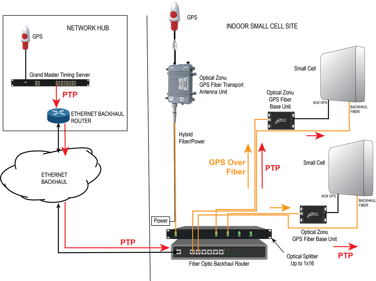
    Small cells close to a network’s edge are usually far from the hub where the grandmaster timing server generates the PTP timing signal and sends it to the network edge over the Ethernet backhaul. The long runs require multiple hops through routers and switches. Each of these adds dynamically changing packet delays depending on network loading. Also, there are inevitable asymmetries between the upstream and downstream packet delays. These timing errors can result in a drastically reduced network performance.

    One way to correct these timing errors is to connect an edge grandmaster server at the small cell location connected to the local backhaul router. Connecting the GPS directly to each of the small cells is the other way.

    The GPS approach is simple in concept, but has been problematic since, with small cells distributed in the facility, many or all the units can be far from a window where a GPS antenna could be mounted.

    Optical Zonu, a U.S. carrier-approved supplier of RF-over-fiber transport solutions, has solved this problem with its GPS at the Edge kit. The GPS-over-fiber solution distributes GPS to each small-cell location alongside the backhaul.

    A compact GPS fiber antenna unit connects to a GPS antenna on the roof. A single cable connection to this unit provides power to the unit and brings the fiber-optic connection to an optical splitter, which is collocated with the local router for the small-cell backhaul.

    The fibers from this splitter are routed along with the backhaul cable to each small-cell location, where they each connect to a small fiber base unit that recovers the GPS signal and connects it to the auxiliary GPS port on each small cell.

    Optical Zonu offers two variants.

    Small cells with fiber-optic backhaul. Higher power cells typically use a fiber-optic backhaul and require local AC power. In this case, one of the fibers in the cable to each small cell is used for the GPS connection, and each base unit connects to the local AC power with an adapter. In this case, the only additional cable needed is the single run to the rooftop.

    Diagram: Optical Zonu
    Diagram: Optical Zonu

    Small cells with a CATx backhaul. This setup is typical for lower power small cells. In this architecture, a single fiber is pulled along with the CAT6 backhaul cable. A single hybrid fiber/CAT6 cable can also be used. The fiber is connected to a small fiber base unit at each small cell to recover the GPS signal, which is connected to the small cell auxiliary GPS port. The CAT6 is also connected to the fiber base unit. The backhaul is passed through from the small cell, and the PoE++ is tapped to power the base unit. Once again, the only additional cable pull is the single run to the rooftop antenna — local power isn’t needed at every small cell location.

    Diagram: Optical Zonu
    Diagram: Optical Zonu

    The Optical Zonu GPS at the Edge kit provides an easy-to-install and cost-effective solution that guarantees the highest timing and phase accuracy for a network that is vendor agnostic and, as with the edge grandmaster approach, still has the central PTP as a backup.

    For more information, visit Optical Zonu.

  • 2020 Automated Vehicles Symposium to be held virtually

    2020 Automated Vehicles Symposium to be held virtually

    Logo: Automated Vehicles Symposium

    The 2020 Automated Vehicles Symposium, hosted by the Association for Unmanned Vehicle Systems International and the Transportation Research Board, will be held July 27-30 as a virtual event.

    “Recognizing the importance of driving engagement on future research, development and deployment of automated vehicles, we are confirming that all of the important content already planned for this year’s program will take place within a fully interactive virtual event platform,” organizers said.

    The event will feature live sessions and networking, as well as a customizable schedule. In addition, keynote and plenary sessions will explore how society, technology and policy are preparing for and shaping the future of mobility.