Australia-based Position Partners has launched MiRTK, an open architecture corrections service for GNSS equipment.
Internet-enabled, MiRTK offers an alternative to UHF radio correction services for high-accuracy GNSS. Unlike UHF radios, MiRTK is not limited by range from the GNSS base station and does not require line of sight with the survey rover or machine.
MiRTK uses a small modem that slides onto the accessory slot of the tripod and connects to the base station via a single cable.
A subscription service is available in locations with the Telstra network, mainly continental Australia.
MiRTK is designed for accurate GNSS positioning in the construction, mining and geospatial industries. It is compatible with all brands and models of GNSS from manufacturers including Topcon, Trimble, Leica Geosystems, Sokkia, Hemisphere and more.
“Until now, users that rely on high-precision GNSS for applications such as surveying and machine control had no option but to use UHF radios or a network RTK solution,” said Cameron Waters, geospatial business manager at Position Partners.
“Anyone that’s had to rely on UHF radio frequencies will have experienced problems, including interference, range limitations, costly licensing and severe penalties for breaching licensing laws. MiRTK offers an alternative that is refreshingly simple: no repeaters, no line of sight issues and no complex licensing,” he added.
The Galaxy lithium mine in Ravensthorpe, Western Australia. (Photo: jasonbennee/iStock / Getty Images Plus/Getty Images)
Another benefit, according to Waters, is the ability to utilise a single correction protocol across all GNSS equipment on site. This dramatically reduces complexity and potential connectivity issues. “MiRTK uses NTRIP and a user selectable format such as RTCM3 or CMR, that can be used universally regardless of the brand or model of equipment,” he said. “Users enjoy full speed, full constellation connectivity without the complex radio settings, baud rates, bandwidth or scrambling problems that you get when trying to utilize different GNSS systems with UHF radios.”
To set up the unit, users simply connect the modem to the base station, power the modem on and MiRTK will work for up to 20 hours continuously without charge. Each unit can connect with up to 10 devices such as survey rovers or machine systems as standard, with unlimited potential to scale up connections as required.
“The future of UHF is limited with lower bandwidth, higher density areas, increased governance, rising costs and little flexibility,” Waters said. “MiRTK gives customers a new approach to receive reliable correction data in a simple and hassle-free way, whilst utilizing their existing GNSS hardware.”
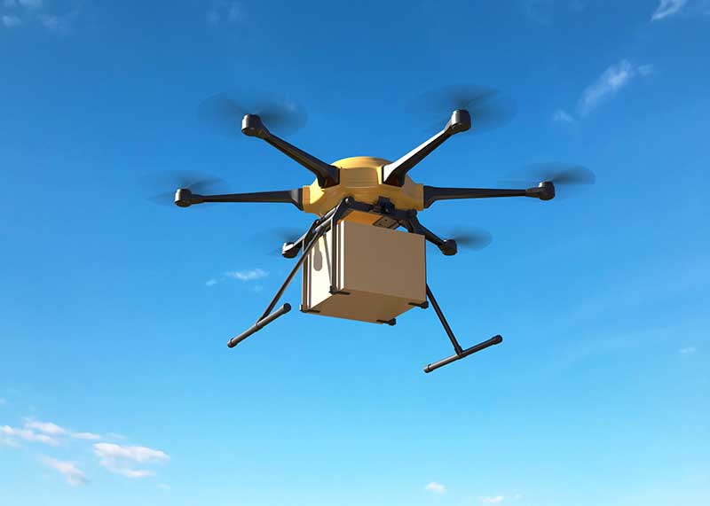
A drone-versus-piloted attack aircraft, deliveries of medical supplies in North Carolina, unmanned meal deliveries in India and anti-drone protection for the Kennedy Space Complex are just a small sample of unmanned air vehicle news this month.
Even the U.K. BBC TV network picked up the news over the weekend that the U.S. Air Force (USAF) plans to pit an unmanned drone against a manned fighter aircraft, maybe even as early as July next year. The candidate fighter drone is thought to come from the USAF’s “Skyborg” research program — a wide ranging initiative aimed at incorporating artificial intelligence (AI) into unmanned vehicles which can out-think and out-fight the opposition.
The logic seems to be that if you could somehow ‘can’ all the experience of today’s pilots – somehow distill all their knowledge and stuff it into electronic memory and have AI use this data-base – then an unmanned fighter drone would somehow do better in combat against a hostile, manned aircraft. Probably a good idea, but how could it be made to work?
The Loyal Wingman in its first test flight. (Photo: U.S. Air Force 88th Air Wing Public Affairs)
And the prime candidate to try all this is out could be the “Loyal Wingman” which was recently rolled out by its manufacturer Kratos. With a target price-tag of only $2 million each (for qty 100), USAF apparently foresees a future with lots of these “disposable’”guys accompanying the manned F-18, F-35, F-22 and future fighters into battle. Perhaps the airborne pilot could even coach his unmanned colleagues through an upcoming dogfight, augmenting the onboard knowledge carried by the drone? Seriously Si-Fi sounding stuff, but its apparently already well on its way.
And would current day autonomous drone operations count as using AI? Well such a drone uses a GNSS nav system and an operator pre-programs a route prior to launch, which the drone then refers to when airborne — even dropping off a package on cue when it arrives at destination, and turning round to fly the same route back home. So referring to an on-board waypoint data-base and executing a beyond visual line of sight (BVLOS) flight on its own — its somewhat limited AI, but the drone is independently doing a task once instructed.
Which brings us to the recent pandemic-related operations that operator Zipline has just begun running out of Kannapolis, North Carolina – from a vacant lot near a Novant Health logistics center — to the Huntersville Medical Center. With only regular capability to operate in accordance with Part 107 regulations, Zipline applied for a waiver to not only fly around population centers, but also to fly beyond visual line of sight (BVLOS). The Federal Aviation Administration (FAA) granted emergency authorization for Zipline to support Novant’s hospital and clinic COVID-19 response.
Fortunately, Zipline is coming off over four years of proven medical drone delivery operations in Rwanda and Ghana, so they have very credible capability to perform similar deliveries in North Caroline. Its possible that FAA took this excellent operational record into account in granting this Zipline waiver.
Nevertheless, Novant and Zipline plan to continue with their efforts to gain full FAA Part 135 authorization to regularly operate this medical package delivery service to Hospitals and Clinics in North Carolina. Meanwhile, this first of a kind long-range BVLOS service in the U.S. will continue to gather more airborne miles each day and demonstrate good confidence in safety and reliability. With over 1.8 million miles already flown during their African medical delivery service, Zipline is apparently coming from an established baseline capability.
In India — a country which has been testing drone services for the express deliveries of food to people’s homes — looks like they are ready to see if drones can be given the OK to operate all the time. The Directorate General of Civil Aviation (DGCA) has authorized a consortium of 13 companies to test drones flying BVLOS over longer distances to complete deliveries. DGCA apparently may have also been motivated to speed up shipments during the COVID-19 pandemic and SpiceXpress, one of the consortium members, will initially focus on delivering medical emergency/essential supplies after the trials are complete.
But overall, the objective for most consortium members is to get approval for meal deliveries by drone to become common practice in India. This will depend on the reports which the trial participants are required to submit to Airport Authority of India by September 30, 2020 from at least 100 hours of flight operations — hopefully without any serious incidents.
Not sure if everyone watched the SpaceX/NASA Demo-2 launch of the manned Dragon capsule on May 30, but I was glued to the NASA TV broadcast throughout. A truly significant event with not only a manned launch to the ISS by a commercial company, but a launch from Kennedy Space Center pad 39A — the first in nine years from U.S. soil.
Turns out we managed to get a ‘drone’ angle into the launch — or actually an absence of pesky drone interlopers at the launch site. Kennedy has been operating an anti-drone system for several previous launches — detecting and alerting any drone activity within the restricted airspace volume around pads 39A &B.
A mobile, all-weather Moog “Gauntlet” detection/alert system has been deployed for some time at Kennedy, watching for anything drone like within the confines of the launch area. The system is apparently visual, records evidence and provides alert indications over a secure VPN network, presumably to launch control and Kennedy security.
So this month we have news of a potential UAV-manned aircraft showdown, long-range drone deliveries of medical supplies in the U.S., Indian delivery drone qualification, and a drone detection system in use to protect the recent SpaceX crewed launch to the ISS. There is a lot going on, with high levels of complexity and good news in the fight against the pandemic for at least one hospital group in North Carolina.
Reaching ’round the world: GPS World staff engage in a teleconference with Editorial Advisory Board members and contributors via teleconferencing. Clockwise from top: Tim Burch, John Fischer, Mitch Narins, William Tewelow, Julian Thomas, Jean-Marie Sleewaegen, Thibault Bonnevie, Ismael Colomina, Michael Swiek, Tony Murfin, Miguel Amor, Alison Brown, Ellen Hall, Brad Parkinson, Stuart Riley, Greg Turetzky, Tracy Cozzens and Matteo Luccio. (Photos: GPS World)
Our readers participated in an online survey on how they are being impacted by and responding to the COVID-19 pandemic. We summarize your responses here.
In April, GPS World asked its readers how the COVID-19 pandemic is affecting the GNSS/PNT industry and their day-to-day work.
About three quarters of respondents fell into two general areas of work: commercial (43%) and government/civilian (33%).
The three biggest market sectors primarily served by respondents’ companies are survey and construction (28%), defense and government (20%), and mapping and geographic information systems, or GIS (14%).
Because of the critical need for mapping during the pandemic, almost all mapping and GIS respondents said they have adapted to answer the needs of those seeking information about the coronavirus pandemic.
Supporting Solutions
About 14% of respondents reported their company has provided products or services for an application, project or customer directly tied to a COVID-19 response. These include support for police and government supervision, government and federal agencies’ emergency vehicles, air transportation, as well as medical supply transport.
Other efforts include ramping up the manufacturing of personal protective equipment such as face shields, with plants repurposed; others donated face masks, disinfectant and money. Also playing a supporting role are IT- and statistic-related services.
Tracking COVID-19. GNSS services provided by our readers to help track the virus include helping multiple agencies monitor traffic to and from critical locations, and building online dashboards for state data and surveillance.
“Our ability to provide GPS network services has enhanced the ability of public- and private-sector surveyors to continue working, to stay employed during these difficult economic times,” said one respondent.
Roadblocks. During the coronavirus pandemic, only 14% said they are significantly challenged to access parts and services, while 41% noticed a slowdown in deliveries. Comments included: “There have been issues getting supplies to set up for telework” and “Some international suppliers are having issues, so we are looking into alternative suppliers.”
Glass Half-Full
While there’s no question the COVID-19 outbreak has presented challenges, many respondents shared positive experiences while working in this current environment.
Working Remotely. For many of us, learning how to work remotely has been a positive experience, providing options that were overlooked or not considered before. Many readers were pleasantly surprised by how easy the transition has been and how well it has worked.
“It’s been a smooth transition to telework and production continues at normal rates,” said one respondent.
Others reflected on their successful adaptability with remote working, with comments such as “We have proven we can function with staff working remotely,” and “It brings people together in new ways!”
“As the team manager, I was fortunate that I had been transitioning my staff to be flexible in their work locations by replacing their desktop computers with notebook computers, enforcing the utilization of shared network resources for project data, and making sure IT systems were working for them — at work, in the field, and at home — prior to the pandemic. This has given me confidence in part-time telework for this group.”
Employees have become “more focused and more productive in necessary areas: documentation, contracts and gaining necessary certifications and contract information.”
Working from home also has improved productivity with fewer meetings and no commuting. “Traffic in any case was horrific.”
Rise of the Machines. Other respondents looked even further to the future. “COVID-19 has given companies and people a wake-up call. The new economy and new dynamics of workforce management will never be the same. This will help us tremendously as we approach AI (artificial intelligence) automation.”
No More Backlogs. While work has slowed in many areas, that cloud can have a silver lining. “It has allowed a backlog of work to be caught up, but we expect that will be temporary as business begins to bounce back.”
Finally, some respondents noted the human factor coming to the fore, including improved hygiene, seeing people help each other, and “more compassion for people in general.”
Photo: Photo: ftwitty / E+ / Getty Images
Where Do We Go from Here?
We asked our readers if coronavirus pandemic-related workflow changes and adaptations have brought about innovations they intend to keep going forward.
Many readers commented that increased reliance on working at home and new digital workflows will continue past the end of the pandemic. Online communication tools cited include email, WhatsApp, Skype, Teams and Zoom. “Knowledge and use of these tools are now ubiquitous,” wrote one respondent.
Others commented that traveling for meetings will be less frequent and reliance on videoconferencing will increase.
Staying Home. Companies plan to continue with at least some staff working from home to reduce their office-space spending. “I will probably have my staff telework two days per week once this pandemic passes. We will have more online training modules prepared. Digital signatures will be the norm.”
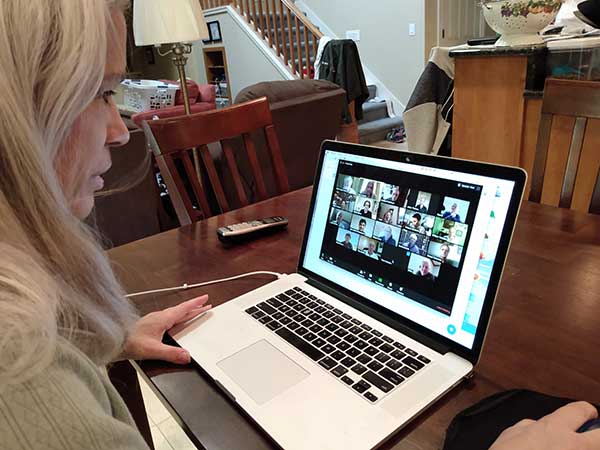
Senior Editor Tracy Cozzens Zooms from her home. (Photo: Steve Cozzens)
One respondent wrote, “We intend to keep using the digital workflow. Accepting and returning PDF plat reviews has worked very smoothly.”
“We are redesigning the logistics of how our business operates — decentralized versus centralized. In this new landscape, businesses cannot be tied to one central location,” another reader wrote.
Others are taking part of the new workflow back to the office: “Videoconferencing has taken on a new light. It works well, and will continue even after we move back to the office.”
Some had a steeper adaptation curve: “As a state government agency, we were not prepared to have the majority of staff working remotely, so we have had significant IT issues.”
Staying Healthy. “We will increase cleaning and sanitizing routines, and all employees and guests will have their temperatures taken before entering, and while on property,” commented one reader.
“The world has changed, and how these changes will affect our business has yet to be determined.”
A Look at Surveying
Surveying companies have adopted remote-office connection strategies and new ways to exchange digital and physical information with their field crews.
About two thirds of professional surveyors have taken steps such as working remotely and videoconferencing to collaborate with colleagues and clients. One respondent said, “We quickly pivoted to working from home by utilizing WebEx and Google Hangouts for collaboration.”
Out in the Field. Some firms are limiting one person per vehicle when traveling to work sites. “Drafting is done via work-from-home on laptops.” Field crews now typically are a single person using GPS and communicating via email.
Going Digital. “The paperless agenda that was difficult to institute is now in place and operational,” commented one surveyor. “It’s often difficult to change until we get that nudge.”
The 1,174 page set of reports are comprehensive and document the first phase of what is intended as a multi-phase effort.
Graphic: RIN and RNTF
The webinar will present how maritime positioning requirements were systematically developed; an assessment of current and future positioning systems to deliver the required performance and integrity; rigorous gap analysis, showing where performance falls short, as well as options to solve these issues; and a roadmap of steps needed to take — and by whom — toward maritime resilient positioning.
Webinar speakers will include Jonathan Turner of the MarRINav project team, Alan Grant of the Royal Institute of Navigation and Dana Goward of the Resilient Navigation and Timing Foundation.
Two F-16 Fighting Falcons fly over Edwards AFB during a 2009 air show. (Photo: U.S. Air Force/Chad Bellay)
The U.S. Air Force in September will begin testing on F-16’s an alternative position, navigation and timing (PNT) solution that uses the Earth’s magnetic anomalies.
The navigation technique, dubbed MAGNAV, is being researched at the Air Force Institute of Technology (AFIT), reports Forbes.
Air Force Major Aaron J. Canciani, an Assistant Professor of Electrical Engineering at AFIT, designed algorithms for MAGNAV flight testing on F-16s. Testing has already taken place using private survey aircraft.
MAGNAV sensors and software will be flown on Air Force Test Pilot School (AFTPS) F-16s over a special test range adjacent to Edwards Air Force Base in Nevada.
Magnetic anomaly navigation uses scalar magnetometer sensors that measure differences in the magnitude of magnetic fields when traveling past them. These variations can be compared with known features in magnetic field maps and be interpreted to determine position.
The four pillars of MAGNAV are magnetic maps, sensors, algorithms and calibration. The magnetic maps already exist within industry, the military and government agencies including NOAA, NASA, NGA and more.
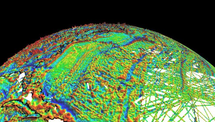
NOAA’s EMAG2 (v3) World Digital Magnetic Anomaly Map. (Image: NOAA National Geophysical Data Center)
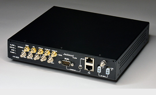
Jackson Labs Technologies (JTL) has launched the PNT-6220 Assured Reference — a product combining low-Earth-orbit (LEO) signals, GNSS, terrestrial, wireline and atomic clock services in one small solution, specifically designed for critical infrastructure applications.
The PNT-6220 reference seamlessly combines concurrent L1, L2, L3 and L5 GNSS reception with a custom JLT-designed LEO-based Satellite Time and Location (STL) timing receiver. It also includes terrestrial receivers and PTP/IEEE-1588 edge grandmaster (EGM) and PTP/IEEE-1588-slave capability.
The PNT-6220 provides assured PNT for critical infrastructure applications such as those described in the directives of Presidential Executive Order 13905.
It can serve as a timing reference for 5G equipment, an ePRTC-capable reference, or a high-performance disciplined reference that supports PTP/IEEE-1588, STL, RF distribution and multi-frequency GNSS capability.
The PNT-6220 will be able to select the most optimal UTC reference input automatically and auto-switchover among its numerous reference inputs if one or more of them are jammed or spoofed, as well as average several references for additional stability and accuracy.
If all external references are jammed, the unit can provide UTC timing from its internal holdover oscillator with options that have less than 100-ns drift over 24 hours. The unit is also capable of outputting a GPS RF distribution signal driven by the internal flywheel oscillator, which allows glue-less retrofitting of any GPS-based legacy user equipment to the state-of-the-art reference sources the PNT-6220 can receive by simply plugging into the legacy equipment GPS antenna input.
Available Options
Numerous options are available for the half-width 19-inch-wide rack-mount box.
U.S. Air Force photo by Airman 1st Class Josie Kemp
The Swedish Defence Materiel Administration (FMV) signed a contract with navigation company iXblue for up to 172 FOG-based Quadrans gyrocompasses. The Quadrans navigation systems will be delivered over four years and will equip the Swedish Navy’s fleet of high speed crafts, mainly combat boats CB90.
“The FMV was seeking new maintenance-free and high-performance gyrocompasses for the retrofit of their fleet of high speed crafts,” said David Cunningham, commercial director at iXblue. “The CB90 vessels are indeed very fast boats and need the most reliable and accurate heading and attitude data to navigate safely. With our Marins Series Inertial Navigation Systems being already in service on the Gotland-class submarines and Koster Class MCMV’s, and our Quadrans gyrocompasses equipping other surface boats in the Swedish Navy fleet, the FMV was familiar with the high-performance delivered by our systems and knew the Quadrans met the specific requirements needed for the CB90.”
The Quadrans gyrocompasses are build around iXblue’s Fiber-Optic Gyroscope technology. According to the company, the gyrocompasses provide highly accurate heading and attitude data and are perfectly suited for high performance at high speeds and in challenging environments such as GNSS-denied settings.
In addition, the Quadrans Gyrocompasses are compact, lightweight and with low power consumption. They’re easy to install on small-sized crafts, while their open architecture guarantees seamless interfacing with all major GNSS systems and third-party navigation software, iXblue added.
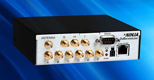
New GPS-synchronized Ninja Precision Timing Module provides a myriad of time and frequency outputs with high performance in a small, low-power platform.
Photo: EndRun
EndRun Technologies, a provider of precision time and frequency solutions, has released the high-performance Ninja Precision Timing Module (PTM). The third-generation Ninja — optimized for size, weight and power (SWaP) — can be easily integrated into 1U host systems or deployed as a cost-effective standalone solution.
The resilient GPS-synchronized Ninja is based on the core of EndRun’s Meridian II Precision TimeBase instrument. Up to nine optional, user configurable, time and frequency outputs are available with accuracy, stability and ultra-low phase noise. Ninja’s network interface includes a robust Network Time Protocol (NTP) server as well as secure management.
Three OCXO reference oscillators are available to meet price-performance requirements. Advanced users can optimize Ninja with EndRun’s innovative Real-Time Ionospheric Corrections (RTIC) to directly measure and compensate for ionospheric delay of received GPS signals in real-time.
“The Ninja Precision Timing Module is another breakthrough solution from EndRun that provides an abundance of outputs in a small form factor without compromising performance,” said Michael Korreng, senior R&D engineer, EndRun Technologies. “The high-level of integration and output versatility readily integrates into many mission critical applications including SATCOM, tactical communications, signal intelligence, security camera synchronization, digital broadcast, network synchronization, range timing, and many more.”
Key Ninja performance specifications with Ultra-Stable OCXO, Real-Time Ionospheric Corrections, and calibration are:
Time accuracy of <10 nanoseconds RMS to UTC(USNO)
Frequency accuracy better than 4×10-14 (100k second average)
GNSS Underground Coverage for Tunnels, Stations, Car Parks, Bus Stations and Airports in the U.K.
Syntony GNSS and Chronos Technology have formed a partnership to deliver underground GNSS positioning, navigation and timing (PNT) solutions for critical infrastructure applications in the United Kingdom.
Syntony GNSS is a leader and expert in the design and manufacture of GNSS systems, and Chronos Technology is a resilient GNSS system integrator.
GNSS coverage has become fundamental to many services from emergency services to asset tracking for example. Yet when entering an underground area such as a metro/subway, tunnel, car park, airport, or bus station for example, the GNSS signal is lost.
Syntony’s SubWAVE solution expands the GNSS coverage to underground areas, enabling the localization of any equipment with a standard GNSS chipset. Examples include standard smartphones and the TETRA Emergency Services Network handset used for security and services. Security and services applications include locating emergency calls, keeping track of staff, locating faults in tunnels, managing assets, locating trains and providing guidance.
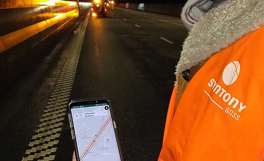
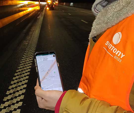
A Syntony team member in a Swedish road tunnel during SubWAVE testing shows the positioning in an underground environment on a smartphone. (Photo: Syntony GNSS)
By emitting a perfect emulation of the “real” GNSS signal, SubWAVE offers underground operators, their staff, emergency services and the general public the benefit of full GNSS coverage in all underground areas for both operational and safety reasons.
One fundamental aspect is the user only needs a standard GNSS receiver (a smartphone or TETRA radio) — no new handsets, receivers or apps are required. The system operates by broadcasting synthetic location specific GNSS signals through existing or new leaky feeder cables in the tunnels.
Accuracy levels vary with leaky feeder and system complexity options; however, 2-meter accuracy is possible with a standard smartphone. The system is widely installed in the Stockholm metro and is in active trials throughout Europe and America.
“We are pleased to form a partnership with GNSS specialists Chronos,” said Joel Korsakissok, president of Syntony GNSS. “Their knowledge and experience, together with their dedicated installation, commissioning and support teams complement our sophisticated solutions.”
“Since its first general availability, one of the well-known shortcomings of the GPS system was lack of indoor or underground coverage,” said Charles Curry, managing director with Chronos. “Many have tried to solve this with various technologies over the years. Syntony’s innovative technology offers underground GNSS coverage for PNT applications. We are very excited by the possibilities and pleased to be partnering with them to offer their solution for critical infrastructure applications in the UK.”
In addition, Chronos will also supply Syntony’s sophisticated GNSS simulators used in the aerospace and defence industries for product testing.
By R. Eric Phelts, Kazuma Gunning, Juan Blanch and Todd Walter
Innovation Insights with Richard Langley
AS WE NOTED IN THE LAST INNOVATION COLUMN, integrity — at least from a safety viewpoint — is the most important characteristic of a navigation system. Yes, accuracy, availability and continuity are also required but, without integrity, the advertised accuracy of a system might become meaningless and perhaps misleading. While GPS and user receivers are highly reliable, we cannot presume that there will never be an erroneous signal transmitted by a GPS satellite that would result in a receiver outputting a hazardously misleading position solution. While “supervisory” systems such as satellite-based augmentation systems monitor GPS signals and can alert users about defective satellites within a very short period of time, it is advantageous for a user receiver to autonomously detect problematic satellites and quarantine them so that they do not perturb the position solution.
It is for this reason that receiver autonomous integrity monitoring (RAIM) techniques were developed. As we know, a receiver needs signals from a minimum of four satellites simultaneously to determine its 3D position and its clock offset. However, typically there are more than four satellites in view, and so multiple solutions using subsets of four satellites are possible. If five satellites are visible, then it is possible to determine that one of them is faulty, but not which one (geometry plays a role here). This is called fault detection (FD). And if six satellites are visible, the faulty satellite can be determined and then excluded from the position solution (fault detection and exclusion, or FDE). This is the basic principle of RAIM.
Advanced RAIM (ARAIM) extends RAIM to other constellations beyond GPS. ARAIM enables the use of the newer GNSS constellations to provide better levels of performance than RAIM with GPS alone. It also uses dual-frequency measurements for enhanced vertical positioning reliability.
Central to positioning techniques providing a safety-of-life service is the notion that the uncertainty of a provided position must be conservatively estimated and provide for both nominal uncertainty and the uncertainty of a faulted solution such as that detected using RAIM. These conservative estimates are known as the horizontal and vertical protection levels. The horizontal protection level (HPL) is the radius of a circle in the horizontal plane with its center at the true position, which describes the region that is assured to contain or bound the provided horizontal position to a very high probability. The vertical protection level is half the length of a segment in the vertical direction with its center at the true position, which describes the region that is assured to contain or bound the provided vertical position to a very high probability. The probability levels are typically taken to be 99.9999998 and 99.99999% for HPL and VPL, respectively.
The usual approach for RAIM and ARAIM is to use the so-called “snapshot” approach, where measurements are assumed to be uncorrelated epoch to epoch. In this month’s column, a team of authors from Stanford University discusses a superior approach for ARAIM using the technique of precise point positioning.
Advanced Receiver Autonomous Integrity Monitoring (ARAIM) is implemented using solution separation in positioning and navigation software. Solution separation computations presume one or more GNSS satellites may be faulty, and they iteratively compute multiple position solutions comprised of subsets of the n satellites in view (n, n-1, n-2, and so on) to ensure that at least one of the solutions is fault-free. Using assumptions on the nominal and faulted uncertainty of the solutions, the software can compute conservative horizontal and vertical protection levels (PLs) by bounding the uncertainty from all the solutions. This assures (to a targeted level of probability) that the user position is contained within these limits.
Traditional solution separation techniques generally operate as a “snapshot.” The basic measurements are dual-frequency, carrier-smoothed pseudorange (code), and errors are generally assumed to be uncorrelated from epoch to epoch. This procedure requires that errors at each time step are conservatively bounded with large uncertainties (sigmas) designed to protect the user against the worst-case error. These assumptions minimize the complexity and computational cost of the solution by providing a robust, provably safe bound. However, the PLs computed are relatively large. In addition, they can change suddenly from one epoch to the next due to changes in available satellites or platform dynamics. This can make meeting performance goals (such as continuity) for aircraft approaches more challenging.
Solution separation procedures using techniques based on precise point positioning (PPP) implement an extended Kalman filter (EKF) to filter measurements over time. In this case, the basic measurements are dual-frequency code and carrier phase, and errors are assumed to have some correlation between each time step to the next. Accordingly, these techniques leverage higher quality measurements (that is, carrier-phase-based as opposed to code-based) to smooth and reduce large sigmas and to estimate (and calibrate) errors over time. The complexity associated with defining and characterizing the decorrelation models for the errors, so that the nominal covariance produced by the EKF conservatively describes the actual error, is significant. Also, the computational cost of estimating the error states may be substantially higher than with the traditional snapshot approach. However, the computed protection levels provide integrity and are often significantly smaller. In addition, the filtering makes them more robust to platform dynamics, which makes them well-suited for aircraft in flight.
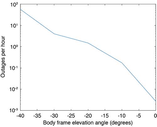
Flight Data: Outages and Cycle Slips. ARAIM performance may be significantly affected by aircraft dynamics. Specifically, banking can induce satellite outages and cycle slips. Outages weaken the constellation geometry and can cause sudden changes in the protection level. Frequent cycle slips prevent code measurements from being smoothed, potentially inflating protection levels of carrier-phase-smoothed code measurements for extended periods of time.
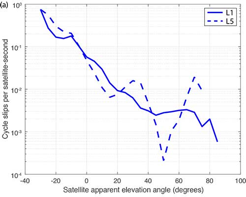
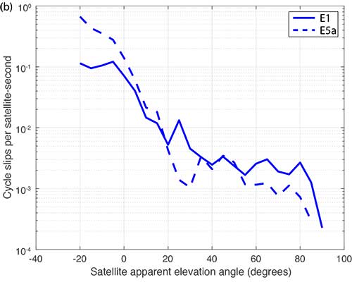
When the outages and cycle slips are computed as a rate, a trend can be seen. Both increase notably as the relative elevation angle to the satellites decrease. FIGURE 1 shows an example of outages as a function of the apparent elevation angle of the satellites (relative to the aircraft). Cycle slips on GPS L1-L5 and Galileo El-E5a are plotted in FIGURES 2 (a) and (b), respectively.
FIGURE 1. Outages as a function of body frame or apparent elevation angle during aircraft banking. (Image: Authors)FIGURE 2a. Cycle-slip rate (per satellite-second) for GPS L1-L5. (Image: Authors)FIGURE 2b. Cycle-slip rate (per satellite-second) for E1-E5a. (Image: Authors)
For this article, we have used the flight data from one of our earlier papers on the effect of aircraft banking on ARAIM performance (see Further Reading). With this data, we show that significant advantages of PPP can be retained even during aircraft maneuvers when outages and cycle slips threaten ARAIM continuity and availability the most.
MODEL ASSUMPTIONS
The traditional snapshot solution separation approach is well-established and was implemented according to the standards established by a working group operating under the U.S.-European Union Agreement on GPS-Galileo Cooperation, which has been extended to all constellations (see Further Reading). For this article, we limited the constellations to GPS and Galileo, and the prior probabilities assumed for satellite and constellation faults were as follows:
Psat = 10-5, Pconst,GPS = 10-8 and Pconst,GAL = 10-4
We implemented the PPP algorithm with solution separation using an EKF using dual-frequency code and carrier-phase measurements (from GPS and Galileo) with estimated parameters comprising the receiver position and velocity, clock biases for each constellation in use, a residual tropospheric delay, carrier-phase float ambiguities for each tracked carrier, multipath error, receiver differential code bias, and broadcast orbit and clock error. Modeled (not estimated) effects include solid Earth tide modeling, ocean loading, an initial tropospheric delay and relativistic effects. Many of the details of the implementation can be found in our paper “Design and Evaluation of Integrity Algorithms for PPP in Kinematic Applications” (see Further Reading).
PPP techniques typically utilize precise ephemeris information obtained from a global network of ground reference stations such as those operating in the network coordinated by the International GNSS Service. Snapshot solution separation techniques, however, use only ephemeris information broadcast from the satellites themselves. For a proper comparison of the protection levels computed by each technique, the PPP filter was constrained to use this broadcast information.
The model we have applied is mostly typical of a traditional PPP implementation with one significant exception — the state tracking the error contribution of the broadcast orbit and clock on each line-of-sight signal. The error contributed by the broadcast orbit and clock is handled by the filter leveraging a characterization of the rate of change of the error, then including it as an estimation state for each line of sight and only adding enough process noise to capture the slowly changing error. We have previously characterized the rate of change of the error in the broadcast orbit and clock and process noise (for GPS). Complete tables of initial state uncertainties and additional settings for process and measurement noise were provided in our earlier work (see Further Reading).
RESULTS
Flight data collected over a period of approximately one year was used to evaluate ARAIM performance through momentary outages and cycle slips due to aircraft dynamics. A multi-constellation, multi-frequency receiver tracked GPS (L1 C/A and L5) and Galileo (E1 and E5a) satellites. This receiver is installed in a Global 5000 jet owned and operated by the FAA William J. Hughes Technical Center. It records and stores GNSS measurements whenever flights are taken. The data we used for this article included data recorded over approximately 35 flights from September 2017 to April 2018.
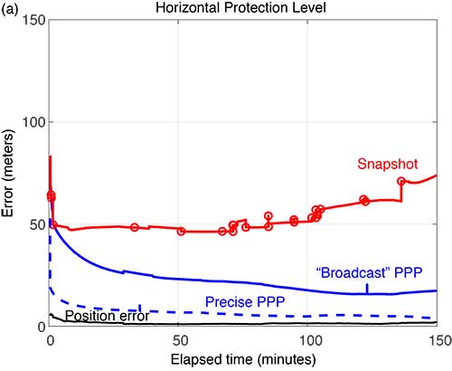
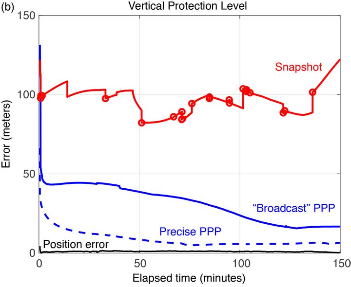
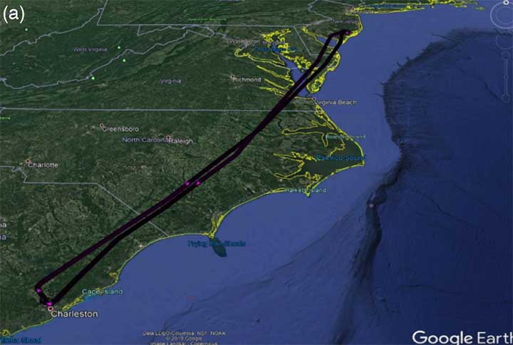
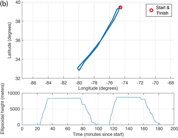
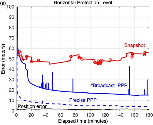
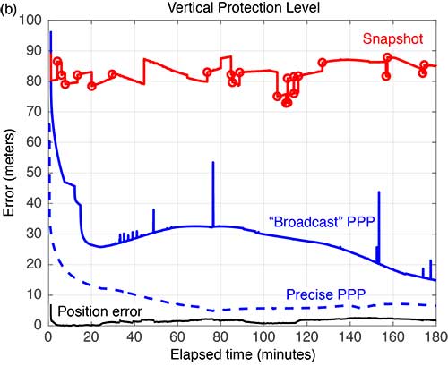
FIGURE 3 shows the trajectory and altitude information corresponding to a single flight (Flight #6) taken on Sept. 20, 2017, and FIGURE 4 compares the corresponding horizontal and vertical protection levels computed using snapshot and “broadcast” PPP techniques. For an additional reference, we also computed protection levels using PPP with precise orbits and clocks (we call this precise PPP despite the terminology redundancy) and plotted these in Figure 4, too.
FIGURE 3b. Altitude information for Flight #6 (Sept. 20, 2017). (Image: Authors)FIGURE 4a. Horizontal protection levels for Flight #6 (Sept. 20, 2017); red circles indicate a satellite being dropped or reentering the solution. (Image: Authors)FIGURE 4b. Vertical protection levels for Flight #6 (Sept. 20, 2017); red circles indicate a satellite being dropped or reentering the solution. (Image: Authors)
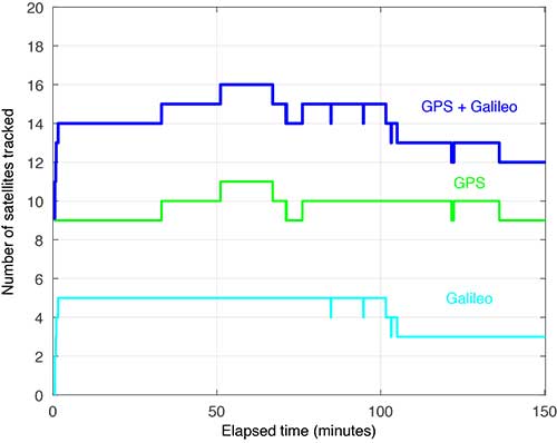
Several things are readily apparent from these comparisons. First, after the initial time required for convergence, there is a substantial reduction in the PLs using the broadcast-PPP-based approach. The precise PPP PLs, as expected, produce the largest reduction, but use additional information not available to the snapshot method. In addition, the snapshot solution separation PLs vary significantly due to cycle slips and momentary satellite outages. FIGURE 5 shows the number of satellites tracked by the receiver during this flight; red circles plotted on the snapshot protection-level line indicate when satellites are coming into and out of view. Despite numerous abrupt changes in number of measurements and measurement quality, the EKF of the PPP techniques produces PLs that are relatively smooth and continuous.
FIGURE 5. Number of satellites tracked for Flight #6 (Sept. 20, 2017). (Image: Authors)
FIGURE 6 shows the trajectory and altitude information corresponding to Flight #4 taken on Sept. 15, 2017.
FIGURE 6a. Flight path for Flight #4 (Sept. 20, 2017). (Image: Authors)FIGURE 6b. Altitude information for Flight #4 (Sept. 20, 2017). (Image: Authors)
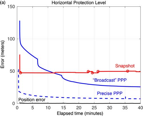
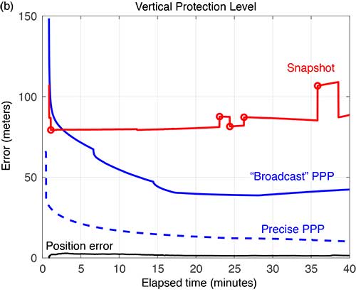
FIGURE 7 compares the horizontal and vertical PLs for snapshot solution separation and the PPP-based techniques.
FIGURE 7. Horizontal protection levels for Flight #4 (Sept. 15, 2017); red circles indicate a satellite being dropped or reentering the solution. (Image: Authors)FIGURE 7b. Vertical protection levels for Flight #4 (Sept. 15, 2017); red circles indicate a satellite being dropped or reentering the solution.
As in the case shown in Figure 4, the PLs in Figure 7 reveal a substantial reduction in the mean PLs computed using the PPP-based approach. And the snapshot solution separation approach displays even more variations due to momentary satellite outages. Some of the cycle slips affected enough satellites to introduce brief spikes in the PPP solution as well. These reconverge quickly, but they suggest that some tuning of the EKF can still be done to mitigate these interruptions. Still, the filtered approach produces PLs that are more robust to the outages and are substantially smaller than with the snapshot method.
FIGURE 8 compares the horizontal and vertical PLs computed using snapshot solution separation and PPP techniques for Flight #20 — where the airplane remained stationary on the runway. In the absence of flight dynamics, the levels for all the approaches were relatively smooth. However, a few discontinuities can still be observed for the snapshot case. Also note, in the case of the broadcast PPP, the convergence time is noticeably longer. This is likely because the integer ambiguity resolution in the solution took longer to converge without platform motion.
FIGURE 8a. Horizonta protection levels for a stationary aircraft (Flight #20, Dec. 4, 2017); red circles indicate a satellite being dropped or reentering the solution. (Image: Authors)FIGURE 8b. Vertical protection levels for a stationary aircraft (Flight #20, Dec. 4, 2017); red circles indicate a satellite being dropped or reentering the solution. (Image: Authors)
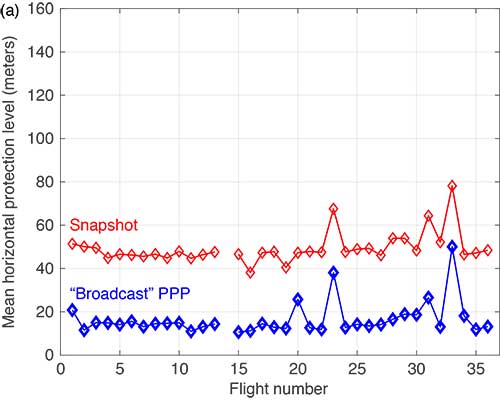
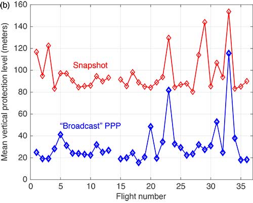
The mean horizontal and vertical PLs for both techniques are summarized in FIGURE 9. (There were issues with the data from Flight #14 and it was not processed.) The PPP approach consistently produces protection levels anywhere from 30 to 75% smaller than those computed using the snapshot approach. The mean PLs for the PPP techniques were always below those computed with the snapshot method.
FIGURE 9a. Comparison of mean horizontal PLs for “snapshot” vs. a PPP-based technique. (Image: Authors)FIGURE 9b. Comparison of mean vertical PLs for “snapshot” vs. a PPP-based technique. (Image: Authors)
CONCLUSIONS
Data from 35 flights was used to compare ARAIM protection levels computed by the traditional “snapshot” solution separation versus a PPP-based approach during both in-flight and several static scenarios. We observed that the filtering of PPP methods yields mean PLs approximately 30 to 75% of those computed using traditional methods in all cases. This improvement can be attributed to exploiting — through filtering and estimation — carrier-phase-based measurements and a time-correlation of the errors. In addition, the EKF employed by the PPP approach demonstrated improved robustness to outages and cycle slips induced by aircraft dynamics. Despite the increased complexity and computational cost, we believe that PPP approaches hold promise for significantly improving ARAIM performance.
ACKNOWLEDGMENT
This article is based on the paper “Evaluating the Application of PPP Techniques to ARAIM Using Flight Data” presented at ION ITM 2020, the 2020 International Technical Meeting of The Institute of Navigation, San Diego, California, Jan. 21–25, 2020.
MANUFACTURER
The flight data was recorded using a Trimble BX935-INS receiver fed by an Antcom Avionic II GNSS antenna.
R. ERIC PHELTS is a research associate in the Department of Aeronautics and Astronautics at Stanford University, California. He received a Ph.D. in mechanical engineering from Stanford University in 2001. His research involves signal deformation monitoring for SBAS and flight-data analyses for ARAIM.
KAZUMA (KAZ) GUNNING is a Ph.D. candidate in the GPS Laboratory at Stanford University working under the guidance of Todd Walter. He is also the navigation algorithms and architecture lead at Xona Space Systems in San Mateo, California. His research interests are in precise point positioning and integrity.
JUAN BLANCH is a senior research engineer at Stanford University, where he works on integrity monitoring algorithms for radionavigation. He received a Ph.D. in aeronautics and astronautics from Stanford University in 2003. He has received The Institute of Navigation (ION) Parkinson and Early Achievement awards.
TODD WALTER is a research professor in the Department of Aeronautics and Astronautics at Stanford University. He received his Ph.D. in applied physics from Stanford University in 1993. His research focuses on implementing high-integrity air navigation systems. He has received the ION Thurlow and Johannes Kepler awards. Walter is also a Fellow of the ION and has served as its president.
“A Baseline RAIM Scheme and a Note on the Equivalence of Three RAIM Methods” by R.G. Brown in Navigation, Vol. 39, No. 3, Fall 1992, pp. 301–316.
Advanced Receiver Autonomous Integrity Monitoring
“SBAS Corrections for PPP Integrity with Solution Separation” by K. Gunning, J. Blanch and T. in Proceedings of ITM 2019, the 2019 International Technical Meeting of The Institute of Navigation, Reston, Virginia, Jan. 28–31, 2019, pp. 707–719.
“Design and Evaluation of Integrity Algorithms for PPP in Kinematic Applications” by K. Gunning, J. Blanch, T. Walter, L. de Groot and L. Norman in Proceedings of ION GNSS+ 2018, the 31st International Technical Meeting of the Satellite Division of The Institute of Navigation, Miami, Florida, Sept. 24–28, 2018, pp. 1910–1939.
“Effect of Aircraft Banking on ARAIM Performance” by R.E. Phelts, J. Blanch, K. Gunning, T. Walter and P. Enge in Proceedings of ION GNSS+ 2018, the 31st International Technical Meeting of the Satellite Division of The Institute of Navigation, Miami, Florida, Sept. 24–28, 2018, pp. 2632–2641.
“Precise Point Positioning” by J. Kouba, F. Lahaye and P. Tétreault, Chapter 25 in Springer Handbook of Global Navigation Satellite Systems, edited by P.J.G. Teunissen and O. Montenbruck, published by Springer International Publishing AG, Cham, Switzerland, 2017.
The non-profit 211 LA County and Slingshot Aerospace have unveiled an online mapping tool that allows users to quickly identify and locate more than 2,000 food resources within the county during and after the COVID-19 pandemic.
211 LA County is a non-profit organization providing the official information and referral source for health and human services in LA County. Slingshot Aerospace is a situational intelligence platform company,
The customized tool, called 211 LA FoodFinder, is powered by Slingshot Earth and is the biggest and only food map that allows LA residents to search for resources by location and view services specific to seniors, children and others, enabling individuals to find aid near them faster. Resources within the FoodFinder are free, with the exception of those with suggested donations or delivery service fees.
LA County residents will be able to identify different types of available food resources, such as child nutrition, meal services, groceries/food pantries, senior food needs and government food benefits programs.
The platform also provides location details, hours of operation and contact information for each of the services. 211 LA County is currently experiencing a tenfold increase in website traffic related to food resources compared to pre-COVID timeframes.
The organization anticipates the robust application to service nearly 30,000 LA County constituents over the next quarter, many of which may not have prior experience with food assistance.
“Food resources are the biggest need people are contacting us about since the COVID-19 pandemic hit LA County,” said Maribel Marin, executive director, 211 LA County. “With so many people out of work, the need for food is going to get progressively more intense, but people shouldn’t worry because there are lots of resources and ways to access them. Our custom Slingshot Earth food locator provides our community with a one-stop-shop for food resource information, helping to provide peace of mind to those who need food assistance during this unprecedented time.”
211 LA County’s customized Slingshot Earth mapping tool aggregates food resources and service data from multiple public and private sources so that individuals have the right information, at the right time, all in one place. The data is verified and updated regularly to ensure that Los Angeles County residents have the most up to date information as guidelines and offerings continue to evolve.
“This work to help 211 LA County provide critical food service information in our community is so meaningful to us because we are driven by a vision to create a safer, more sustainable world,” said Mel Stricklan, Co-Founder and Chief Strategy Officer, Slingshot Aerospace. “Our business was founded on the idea that information is power, especially in complex situations. The COVID-19 pandemic is uncharted territory for all of us, and we are happy to do our small part in navigating these tough times by providing essential information to those who need it most.”
Orolia has launched the virtual Orolia Air Show, which will take place June 23-26. The free event aims to connect the global aviation industry.
“As the aviation industry is deeply impacted in daily operations and trade shows are on hold, Orolia is highlighting the importance of aviation technologies with this global event,” the company said.
Attendees will have the opportunity to catch up on the latest industry updates and compliance requirements in a series of one-hour sessions.
Session topics will include the next generation emergency locator transmitters for commercial airlines; combat search-and-rescue beacons to support critical military missions; advanced GNSS anti-jamming and spoofing solutions for commercial and military critical infrastructure; and timing and synchronization embedded systems.
Founded in 2006 and headquartered in France, Orolia provides resilient positioning, navigation and timing solutions.
 Australia-based Position Partners has launched MiRTK, an open architecture corrections service for GNSS equipment.