The National Space-Based Positioning, Navigation, and Timing Advisory Board continued its discussions on how best to protect, toughen and augment GPS at its 31st meeting, which took place Dec. 4-5 at the Sonesta Redondo Beach and Marina in Redondo Beach, California. The meeting was convened by James J. Miller, of NASA, who is the board’s executive director, and chaired by retired Adm. Thad Allen of the U.S. Coast Guard.
On the first day, after hearing reports from its six subcommittees, the board heard the following presentations:
Karen Van Dyke, director, PNT & spectrum management, Department of Transportation (DOT), on DOT’s IDM and complementary PNT work.
Maj. Christine Bonniksen, retired from the U.S. Air Force, deputy director for flight projects, NASA Langley Research Center, and Shachak Pe’eri, Ph.D., acting director, National Geodetic Survey, National Ocean Service, National Oceanic and Atmospheric Administration (NOAA), on NOAA’s implementation of a GDGPS-based GPS High Accuracy and Robustness Service.
Anh Nguyen, Ph.D., NASA flight opportunities program (Bryce Space and Technology, LLC) and Lisa Valencia, NASA Space Communications and Navigation Program (Overlook Systems Technologies, Inc.) on the SpaceLoft 15 multi-GNSS flight experiment (see the article on p. 16).
Allison Kealy, Ph.D., director of the Innovative Planet Research Institute, Swinburne University, Australia, on resilient PNT.
Brad Parkinson, Ph.D., the board’s first vice chair, on a comparison of GPS with the other GNSS.
Satoshi Kogure, senior chief officer of satellite navigation technology, Japan Aerospace Exploration Agency on Japan’s Quasi-Zenith Satellite System (QZSS).
Moon Beom Heo, Ph.D., executive director of KPS R&D Directorate, Korea Aerospace Research Institute on the Korean Positioning System (KPS).
Matt Higgins, international engagement subcommittee chair on Galileo.
Cordell DeLaPena, executive officer, MilComm & PNT, Space Systems Command, USSF on the status of the GPS program, including L5, OCX, civil signal monitoring, resilient-GPS and low-Earth orbit PNT.
On the second day, the board held a roundtable discussion, then heard updates from its international members and representatives. For video of the proceedings, go to youtube.com/@nationalpntboardmeetings822/streams.
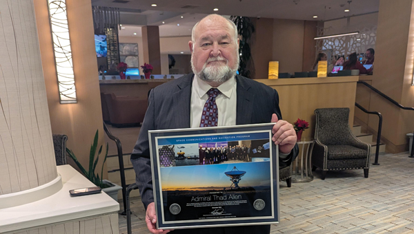
To celebrate Allen’s long service as this board’s chair, NASA conferred a beautiful plaque to him, bearing the following text:
“PRESENTED TO Admiral Thad Allen
With our deepest gratitude, the NASA community and our many partners are very thankful for the friendship and dedicated leadership you have provided as the Chair of the National Space-Based Positioning, Navigation, and Timing Advisory Board. Your advocacy on behalf of GPS users worldwide will always be remembered and cherished. December 2024
Kevin Coggins
Deputy Associate Administrator, Space Communications and Navigation
NATIONAL AERONAUTICS AND SPACE ADMINISTRATION”
“Seen & Heard” is a monthly feature of GPS World magazine, traveling the world to capture interesting and unusual news stories involving the GNSS/PNT industry.
Waymo opens autonomous rides in LA
Photo: Waymo
Waymo has launched its fully autonomous ride-hailing service in Los Angeles, available 24/7, following a waitlist of nearly 300,000 users before its rollout. The service covers nearly 80 square miles of Los Angeles County, including Santa Monica, Hollywood Boulevard and the University of Southern California. Waymo plans to expand its coverage as it scales its operations.
A large UAV show in Quanzhou, Fujian Province, China, ended in disaster when hundreds of UAVs crashed due to GNSS jamming. The event, intended to celebrate the city’s history with 2,000 UAVs equipped with low-altitude fireworks, faced significant disruptions when a camera drone entered the area without notifying authorities, leading them to mistakenly jam the signal. This incident resulted in an estimated loss of more than 10 million yuan ($1.4 million)
ISPRA project unveils coastal habitats of Italy
Photo: ISPRA
The PNRR MER A16-A18 project, led by the Italian Institute for Environmental Protection and Research (ISPRA), has released its first preliminary data for mapping Italian coastal habitats through the WebGIS Virgeo cartographic platform. The project focuses on mapping the growth of the Posidonia oceanica and Cymodocea nodosa meadows, which are crucial for biodiversity. Using high-resolution satellite imagery, lidar sensors and autonomous unmanned vehicles, the project is creating a comprehensive database for marine coastal ecosystem management and protection.
Celestial navigation system for UAVs
Photo: Cpl. Harrison Rakhshani
Researchers at the University of South Australia have developed a celestial navigation system for UAVs. The new system combines visual observations of the stars with standard autopilot technologies. In tests of the system using a fixed-wing UAV, researchers could pinpoint its position within 2.5 miles. This technology can be deployed by UAVs in GPS-compromised or denied areas by eliminating the need for GPS.
Nearly three quarters of Earth’s surface is covered by water, yet only about a quarter of that surface has been mapped in detail using modern high-resolution technology.
Marine experts worldwide work together to chart the ocean floor, ensuring the safety of ports, harbors and navigable routes. This effort is crucial for global trade, as more than 90% of goods are transported by ships. Ocean floor surveying also supports the installation of offshore infrastructure such as fiber optic cables, pipelines, drilling platforms and wind turbines.
The increasing population in coastal regions and rising sea levels due to climate change have heightened the importance of observing coastal transformations, erosion and other marine alterations. These factors are essential for understanding and protecting coastal ecosystems.
Mapping techniques
In deep waters, massive multi-beam echo sounders (MBES) operating at very low frequencies collect depth data. As water depth decreases, smaller devices with higher frequencies and resolution must be used. However, near the shore, these devices become less efficient due to the slope of the shelf interfering with sound signals.
In near-shore scenarios, collecting depth data is best done using airborne lidar sensors, which offer several advantages over sensors on surface vessels. One advantage of airborne sensors is that they can simultaneously map both the seafloor and the adjacent topography to offer seamless land-water transition data. This capability is particularly valuable in dynamic coastal environments where rapid coverage of large areas is essential.
Bathymetric lidar is specifically designed for mapping shallow coastal waters, typically effective up to depths of 50 m. It can provide high-resolution data, often achieving sub-meter positional accuracy, which is crucial for detailed coastal mapping. By combining MBES for deeper waters with lidar for near-shore areas, researchers and surveyors can create comprehensive and accurate maps of the entire coastal zone. This method offers an in-depth understanding of underwater topography, aiding various applications in marine science, coastal management and navigation.
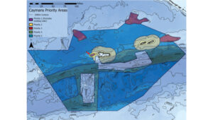
The waters of the Cayman Islands are abundant in marine life, featuring coral reefs, seagrass beds and a variety of fish species. A high-resolution map of the seafloor is essential to begin exploring, identifying, characterizing, exploiting, conserving and managing ocean resources. Saildrone has begun a mission to map 29,300 square nautical miles (100,490 sq km) of the Cayman Islands’ Exclusive Economic Zone (EEZ). This mission uses autonomous technology to survey 80% of this EEZ.
The Cayman Islands EEZ, extending up to 200 nautical miles from shore, encompasses an area nearly half the size of Florida — and 380 times greater than the island itself. The mission will provide detailed and precise bathymetric data for this area, contributing to a comprehensive understanding of the seafloor topography in the region. The data collected seeks to enhance maritime navigation and support scientific research, environmental conservation efforts and marine resource management in the Cayman Islands.
“Our waters hold such great value to us for a myriad of reasons, ranging from recreational to economic. Conducting this assessment will allow our government to make data-driven decisions that will strengthen our policies and legislation as it relates to our maritime infrastructure,” said Juliana O’Connor-Connolly, premier and minister for District Administration and Lands.
The Saildrone Surveyor USV is a purpose-built platform for autonomous deep-water ocean mapping. (Photo: Saildrone)
The mission is philanthropically funded by the London and Amsterdam Trust Company Limited, a Cayman-based organization. Saildrone is tasked with collecting the raw bathymetry data, which will be provided to the UK Hydrographic Office to process and update the Cayman Islands’ nautical charts. The data will belong to the government of the Cayman Islands.
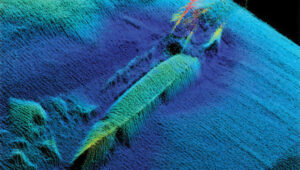
Autonomous seafloor exploration
The mission is being conducted using a 20-m Saildrone Surveyor uncrewed surface vehicle (USV) equipped with MBES and metocean sensors for ocean mapping and ecosystem monitoring, as well as radar, cameras and advanced machine learning. Metocean stands for meteorology and physical oceanography. Globally, only 26% of the ocean has been mapped, a result of the lack of survey ship capacity. While a survey ship takes years to build, Saildrone can produce one Surveyor in as little as six weeks.
This nautical chart shows the Cayman priority mapping areas. The yellow oval indicates the vessel’s location as of Dec. 9, 2024. (Photo: Saildrone)
Saildrone USVs have demonstrated a reduction of more than 97% in operational carbon emissions when compared to survey ships to accomplish the same task. Additionally, they lower the risk to personnel. This information is highlighted in Saildrone’s Carbon Impact Report, which provides a comprehensive evaluation of the carbon emissions associated with maritime data collection and the emissions mitigated by using Saildrone’s USVs.
Saildrone’s ocean mapping solutions support storm surge modeling efforts and emergency response, as well as coastal resiliency and hazard studies, resource management, restoration projects, habitat mapping and infrastructure for renewable energy generation. USVs equipped with deep ocean mapping sonars now serve as a reliable option for data collection in large areas such as EEZs.
Bathymetry is crucial to understanding Earth’s aquatic environments. Its importance has evolved significantly since the early days of navigation, when mariners relied on lead lines and poles to gauge water depths. The field of bathymetry continues to advance with emerging trends that enhance data collection capabilities. Autonomous platforms such as USVs and autonomous underwater vehicles are increasingly utilized for bathymetric surveys, allowing for more extensive and detailed mapping. Additionally, as the industry grapples with challenges such as workforce shortages and the need for more efficient data collection methods, autonomous systems are proving to be a valuable solution.
Trimble’s Applanix POSPac MMS, an advanced GNSS-inertial post-processing software, seamlessly integrates with the Applanix POS MV and multibeam or sonar sensors to deliver high-accuracy results. (Photo: Trimble)
“Autonomous and uncrewed platforms have become a real force multiplier, and the trend continues,” said Peter Stewart, director of marine products at Trimble Applanix. “Companies such as XOcean and Saildrone are showing what is possible, leveraging cloud processing and enabling data collection in remote areas while maintaining a work-life balance for their staff. Since finding qualified engineers and surveyors to fill these roles offshore is an industry-wide concern, more flexible working conditions are needed to hire and retain talent.”
Another emerging trend is the development of sensors capable of penetrating murky waters, which can significantly enhance surveyors’ ability to gather data in challenging environments. Advanced sonar systems, innovative light-and-sound combinations and newly developed sensors allow research teams to collect detailed data. Post-processing technology for bathymetry has also significantly advanced, making data acquisition, processing and presentation more efficient and accessible. This allows researchers to map and study underwater terrains that were previously inaccessible or poorly understood.
Typical marine vessel data processed in POSPac MMS PP-RTX mode. (Photo: Trimble)
“Ease of use and installation are key trends toward ensuring valuable hydrographic data can be acquired, processed and presented efficiently,” Stewart said. Trimble works with users and third parties to offer an optimal workflow, making technology and the data it creates more accessible and operations more efficient, he added.
The IN-Fusion+ PP-RTX2 processing mode in Trimble’s POSPac MMS software is designed to improve post-processed GNSS-inertial trajectory generation. This mode uses Trimble’s CenterPoint RTX technology to deliver centimeter-level positioning accuracy without the need for local base stations. Stewart shared how this technology can be particularly useful when surveying around offshore windfarms, where shore-based RTK infrastructure is often too distant to be useable.
The Directorate of Defense Trade Controls (DDTC) has changed the regulatory status of Controlled Reception Pattern Antennas (CRPAs) for position, navigation and timing (PNT). Starting September 2025, CRPAs will no longer be subject to the International Traffic in Arms Regulations (ITAR). Instead, they will be reclassified under the less restrictive Export Administration Regulations (EAR) list, which is under the jurisdiction of the Department of Commerce.
The rule, in part, removes items from the U.S. Munitions List (USML) “that no longer warrant inclusion.” According to the rule, “certain anti-jam antennas no longer provide a critical military advantage, with increasing commercial utilization applicable to civil GPS resiliency.” By removing CRPAs for PNT, “the Department intends to facilitate civil global navigation system resiliency.”
The recent regulatory change is expected to significantly impact several industries, including airlines, autonomous vehicles, UAVs and critical infrastructure applications, which can benefit from the increased availability of CRPAs. Additionally, this change may open the U.S. market for CRPA manufacturing, potentially resulting in swift technological advancements and lower costs.
The importance of CRPAs lies in their ability to protect GNSS receivers from interference and jamming. GNSS signals are inherently weak and susceptible to both deliberate and unintentional interference. CRPAs work by adjusting their reception pattern to create nulls in the direction of interfering signals while maintaining reception from desired satellite signals. This adaptive beam steering capability allows CRPAs to effectively eliminate signals from particular directions while preserving signals from others, making them a powerful tool in ensuring the reliability of GNSS-dependent systems.
The 2025 Los Angeles Geospatial Summit will be held Feb. 28 at the USC Hotel in Los Angeles.
Each year, leading organizations in geospatial science — including Esri, Eclipse Mapping and GIS, NV5 Geospatial, HRL Laboratories — gather to explore innovative ways geospatial science can address urgent challenges in urban planning, environmental sustainability and public health through advanced spatial data and analysis.
Event highlights
The summit will commence with a keynote address by Daniel Gall, FACHE, deputy chief strategy officer of the Veterans Health Administration, titled “Geospatializing the Veterans Health Administration.” Following the keynote, John P. Wilson, Professor and Founding Director of the USC Spatial Sciences Institute, will moderate a discussion with Gall and Courtney Fassett from Deloitte Consulting, focusing on emerging trends in the geospatial industry.
Afternoon sessions will feature expert presentations and panel discussions exploring decision-making processes using geospatial data. Researchers and professionals from HRL Laboratories, Placer.ai, and other organizations will share insights into emerging geospatial technologies and methodologies. The University of Redlands Dean Thomas Horan will moderate a closing session on “Empowering the Geospatial Workforce of the Future,” featuring panelists from the Open Geospatial Consortium and Esri.
A highlight of the event will be the annual ArcGIS StoryMaps Competition, sponsored by Esri. Students from Southern California universities will compete for prizes in categories including innovative technology use, compelling map communication, and methodological analysis. Three selected students will also present research in a lightning talk session, with expert feedback from industry professionals.
GIS and geospatial sciences students from any college or university, as well as industry professionals, can register for the Summit and learn more here.
Topcon Positioning Systems has expanded its Topnet Live reference station network by adding 200 new geodetic stations across the United States. This expansion enhances the availability of centimeter-level accuracy for industries requiring precise positioning, such as engineering, surveying, construction and agriculture.
The upgraded network provides advanced network corrections that optimize operational workflows in various sectors. The enhanced infrastructure supports emerging technologies such as automated turf management, precision line marking, imaging systems and UAV operations for mapping and delivery.
This expansion builds upon previous efforts throughout 2024, resulting in a 30% increase in Topnet Live’s total coverage in the United States. The network now offers comprehensive, network-modeled solutions that cater to a wide range of professional requirements across multiple market segments.
The Topnet Live network utilizes Networked Transport of RTCM via Internet Protocol (NTRIP) to stream GNSS corrections data via the Internet for RTK positioning. This technology allows for centimeter-level accuracy by mitigating errors from factors such as ionospheric disturbances, satellite clock deviations and orbit inaccuracies.
Jan Van Hees, vice president of business development and product management at Septentrio, talks about the Joint Navigation Conference (JNC) 2024 and Septentrio’s jamming and spoofing solutions.
I am very pleased to announce that professor Washington Yotto Ochieng has agreed to join our Editorial Advisory Board.
He is the current head of the department of civil and environmental engineering and chair professor in positioning and navigation systems at Imperial College London, where he has been on the faculty since 1997. He is also the interim director of the college’s Institute for Security Science and Technology. Among his several other current roles, he is the president of the Royal Institute of Navigation, formed in 1947 following the example of the U.S. Institute of Navigation; a member of the board of trustees of the Science Museum Group appointed by the UK prime minister; and chair of the advisory board of the Science Museum in London.
For a much longer bio of Ochieng, including his full list of titles and honors, visit here.
GPS World featured Ochieng in its May 2009 issue, in a special section on “GNSS Leaders to Watch.” We wrote that he was “excited by the potential benefits of the new signals from modernized and new signals, and their integration with novel terrestrial systems/sensors.”
He has proposed the following question for EAB discussion:
When we discuss the security of GNSS/PNT systems, we nearly always focus on interference — i.e., meaconing, intrusion, jamming or spoofing. However, GNSS/PNT systems are embedded in systems of systems that also offer many other opportunities for cyberattacks. What should we do about it? We will publish responses from other EAB members in the next issue.
Finally, our heartfelt thanks to Terry Moore and Jean-Marie Sleewaegen, who resigned from the EAB, for their many contributions over the years, and a special thanks to Jules McNeff, who has served on the EAB since the magazine’s inception 35 years ago!
The U.S. Space Force transferred Satellite Control Authority of the GPS III Space Vehicle 07 (SV-07) to the 2nd Navigation Warfare Squadron, Mission Delta 31, at Schriever Space Force Base, Colorado. The satellite became operational and available to global users on Jan. 22, 2025 — expanding the GPS constellation to 31 active vehicles. The transfer is the first instance in which the Satellite Control Authority moved from the acquisition program to the operations squadron within a single Delta, reflecting the new mission delta structure.
The space vehicle was launched on Dec. 16, 2024, from Cape Canaveral Space Force Station, Florida, aboard a SpaceX Falcon 9 rocket as part of a Rapid Response Trailblazer mission. The operation involved retrieving an existing GPS III satellite from storage, expediting integration and launch vehicle preparation, and swiftly processing the satellite for launch.
The entire process, from initiation to launch, was completed in approximately three months, significantly shorter than the typical six-month pre-launch processing timeline. This accelerated timeline was achieved through collaboration between multiple Space Force organizations and partner agencies.
The GPS III SV-07 satellite is equipped with M-code, designed to improve anti-jamming and anti-spoofing capabilities, enhancing secure access to military GPS signals. This launch contributes to the ongoing modernization of the GPS constellation following the launch of GPS III SV06 in 2023. Mission Delta 31, activated on Oct. 15, 2024, is responsible for providing, operating, and sustaining high-integrity positioning, navigation and timing (PNT) capabilities. It comprises three squadrons and one detachment, including the 2nd Navigation Warfare Squadron, which operates the GPS satellite constellation.
Septentrio has introduced the mosaic-G5 series, a new range of GNSS receiver modules tailored for robotics and other applications requiring compact components.
These modules represent a significant advancement in size and power efficiency, offering a 60% reduction in size and 40% lower power consumption compared to the mosaic-X5 receiver while maintaining high performance standards. This improvement enables reliable, high-accuracy positioning for devices where minimal size, weight, and power are critical, such as commercial UAVs, compact industrial robots, and high-performance handheld devices.
The mosaic-G5 series expands Septentrio’s existing mosaic portfolio, known for its all-band GNSS technology and robust performance in accuracy, reliability, and resistance to jamming and spoofing. This broad product lineup provides users with the flexibility to select the most suitable module for their specific design requirements.
The mosaic-G5 modules will be gradually released throughout 2025.
PNT services are integral to industries worldwide, from logistics and telecommunications to critical infrastructure. The rise of LEO satellites is set to revolutionize this space, overcoming limitations of traditional GNSS, such as vulnerability to interference and limited urban coverage, according to FrontierSI.
Key insights from the report, which is the first in a series of annual reports, include:
Industry impacts: How LEO PNT addresses GNSS vulnerabilities, offering more robust and accurate navigation solutions.
Government and regulatory challenges: The rise of commercial PNT players necessitates collaboration to address interoperability, spectrum management and governance issues.
Business innovation opportunities: Critical sectors such as logistics and autonomous systems stand to benefit from assured and precise PNT services.
Investment potential: The nascent stage of the LEO PNT market presents opportunities for investors to identify game-changing technologies and key players.
The report is recommended for professionals and organizations deeply engaged in satellite navigation, including:
Engineers, designers and project managers in the space and defense industries
Autonomous systems manufacturers
Policymakers and regulatory bodies responsible for satellite navigation and spectrum management
Commercial stakeholders in telecommunications, transport and logistics
Academics, researchers and analysts with an interest in satellite navigation technologies
Investors analyzing the growth potential of LEO PNT solutions
Providers of critical infrastructure reliant on precise timing synchronization
The LEO PNT State of the Market Report aims to provide stakeholders with the necessary insights to navigate this transformative period for PNT.
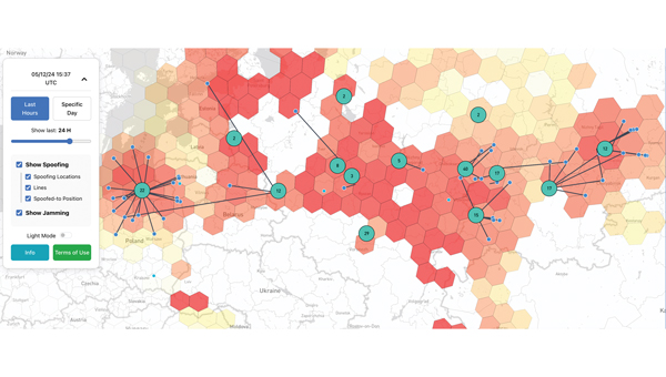
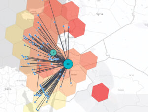
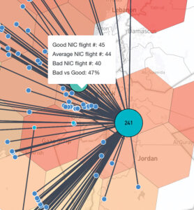
A closer look at potentially spoofed aircraft in the Middle East on Dec. 5, 2024. The map indicates that roughly 244 flights were potentially spoofed in Jordan and the surrounding areas. The level of spoofing is indicated by the color of the hexagons — the redder the hexagon, the more jamming was observed. (Photo courtesy of SkAI Data Services)
Electronic warfare techniques, such as GPS spoofing and jamming, are on the rise. With the increasing prevalence of this sophisticated form of warfare, industry experts must be aware of the threats and find ways to manage them to protect daily operations and civilians. It is important to contribute to the conversation about strategies to mitigate these risks.
SkAI Data Services has answered the call by creating a live GPS Spoofing and Jamming Tracker Map. The map — available at spoofing.skai-data-services.com — utilizes live ADS-B data from the OpenSky Network to identify and display potentially spoofed aircraft in real time and where GPS jamming activity was observed within the past few hours. SkAI Data Services developed the algorithms with the support of the Zurich University of Applied Sciences — Centre for Aviation.
The blue markers represent the positions of aircraft just before they were spoofed. Users can hover over the lines to view information about the affected flights or over the hexagons to access insights on the level of interference. (Photo courtesy of SkAI Data Services)
The map displays clusters that indicate areas where spoofed GPS positions of aircraft have been detected. The numbers within each cluster show how many flights were spoofed at that specific location.
The blue markers represent the positions of aircraft just before they were spoofed. The lines connect these real positions to their corresponding spoofed locations. The map also displays areas of potential GPS jamming or radio frequency interference, indicated by colored hexagons. The redder the hexagon, the more jamming was observed. While not all pre-spoofed locations can be detected, increasing the window duration will reveal more lines.
Similar to gpsjam.org, SkAI Data Services uses the reported navigation integrity category (NIC) to identify these zones. Users can hover over the hexagons to see the number of aircraft reporting good NIC (greater than 7), average NIC (between 5 and 7) and bad NIC (less than 5). SkAI Data Services also offers custom API endpoints to integrate jamming and spoofing data into third-party products.