On the day of the solstice, June 21, geospatial professionals around the world and members of Land Surveyors United (a global support network for land surveyors) will be simultaneously recording survey-grade GPS data from thousands of points around the globe, to gain a more accurate understanding of the earth’s surface.
Measurements made on Survey Earth in a Day 4D (SEIAD) will serve as comparative data from prior events and to expand upon the database of logged points. “This year it will be called 4D, as we will be layering the data from our previous three years into a single map, representing points data gathered from thousands of locations around the planet by professional surveyors,” organizers said. “This day is the largest geospatial event in history as it allows surveyors to participate in their own location. With close to 3,000 more members than we had last year, we are hoping that all of you will participate from your location on June 21.”
In 2012 the first Survey Earth event was held, establishing many new understandings between geospatial and geomatics professionals and the general public on geospatial issues, organizers said. “With a mission not only to learn more about the Earth’s surface but also monitor its changes over time, and the changes in public perspective, as a global community, we may be more capable of assessing our future,” organizers said.
The conference will open with keynote speeches by Chris Cappelli (Esri Inc.) on “The Age of the Location Platform: How Mapping and GIS are Transforming the Work Environment” and Prof. Georg Gartner (TU Wien, Vienna University of Applied Sciences), president of the International Cartographic Association, on “The Future of the Map – the Map of the Future.”
“The agenda for the INTERGEO conference in Stuttgart is packed with exciting topics that are the focus of ongoing political debate on the digital world and will play a key role in shaping the way we work in future,” reads a statement by INTERGEO. “With keynote speeches and plenary talks delivered in English and simultaneous interpreting provided for one strand of the conference on the second day, it is clear that INTERGEO is also becoming increasingly significant on an international scale.”
The major topic of discussion at 2014’s INTERGEO remains a key part of the conference this year — INSPIRE examines geo-issues from a European perspective, providing practical examples and focusing on further development of the European directive. Other central themes include geodata as a basis for construction management and land development, a major concern for future development at regional and local level, as well as issues relating to property markets and valuation. These subjects are all crucial when it comes to discussing the “smart cities” and “smart villages” of the future, according to INTERGEO.
Another highlight of INTERGEO in Stuttgart this year will be the panel discussion on the second day on “Geospatial Information – A Key Element for Emerging Markets.” The high-profile panel of speakers include Bengt Kjellson (UN-GGIM Europe), Ola Rollen (Hexagon), Steve Berglund (Trimble) and Chris Cappelli (Esri Inc.).
A further key topic at the conference that is set to have a profound effect on the working world is geoinformation and mobility. DDGI and DVW will be addressing this together and discussing practical examples in two event strands.
The contributions on big data will focus on the rapid development of data capture, processing and presentation as well as the direct integration of data into business processes. Geoinformation as an element of networked processes is a subject of major international significance, as evidenced by the conference’s high-profile speakers. “In terms of digitization, the conference will be key to paving the path to Geospatial 4.0 and the networking of digital geodata,” said Prof. Karl-Friedrich Thöne, president of the event’s host, DVW, adding, “INTERGEO is the ideal forum for creating processes that could eventually benefit the entire value-added chain.”
As important as data may be in the digital world, it is also crucial to have the right visualization concepts in place. This will be demonstrated through presentations on the German Cartographers’ Day, which will form part of INTERGEO this year.
The conference will be open with keynote speeches by Chris Cappelli (Esri Inc.) on “The Age of the Location Platform: How Mapping and GIS are Transforming the Work Environment” and Prof. Georg Gartner (TU Wien, Vienna University of Applied Sciences), president of the International Cartographic Association, on “The Future of the Map – the Map of the Future.”
“The agenda for the INTERGEO conference in Stuttgart is packed with exciting topics that are the focus of ongoing political debate on the digital world and will play a key role in shaping the way we work in future,” reads a statement by INTERGEO. “With keynote speeches and plenary talks delivered in English and simultaneous interpreting provided for one strand of the conference on the second day, it is clear that INTERGEO is also becoming increasingly significant on an international scale.”
The major topic of discussion at 2014’s INTERGEO remains a key part of the conference this year — INSPIRE examines geo-issues from a European perspective, providing practical examples and focusing on further development of the European directive. Other central themes include geodata as a basis for construction management and land development, a major concern for future development at regional and local level, as well as issues relating to property markets and valuation. These subjects are all crucial when it comes to discussing the “smart cities” and “smart villages” of the future, according to INTERGEO.
Another highlight of INTERGEO in Stuttgart this year will be the panel discussion on the second day on “Geospatial Information – A Key Element for Emerging Markets.” The high-profile panel of speakers include Bengt Kjellson (UN-GGIM Europe), Ola Rollen (Hexagon), Steve Berglund (Trimble) and Chris Cappelli (Esri Inc.).
A further key topic at the conference that is set to have a profound effect on the working world is geoinformation and mobility. DDGI and DVW will be addressing this together and discussing practical examples in two event strands.
The contributions on big data will focus on the rapid development of data capture, processing and presentation as well as the direct integration of data into business processes. Geoinformation as an element of networked processes is a subject of major international significance, as evidenced by the conference’s high-profile speakers. “In terms of digitization, the conference will be key to paving the path to Geospatial 4.0 and the networking of digital geodata,” said Prof. Karl-Friedrich Thöne, president of the event’s host, DVW, adding, “INTERGEO is the ideal forum for creating processes that could eventually benefit the entire value-added chain.”
As important as data may be in the digital world, it is also crucial to have the right visualization concepts in place. This will be demonstrated through presentations on the German Cartographers’ Day, which will form part of INTERGEO this year.
Pictometry International Corp. has secured an order from the Los Angeles Region – Imagery Acquisition Consortium (LARIAC) to provide digital terrain datasets through LiDAR capture of the 4,000+ square mile area that makes up Los Angeles County. Pictometry is a subsidiary of EagleView Technology, a provider of aerial imagery, data analytics and GIS solutions.
The LiDAR project will allow consortium members access to the digital data and imagery for use in 3D modeling, floodplain and watershed mapping, disaster management, land-use planning, transportation planning, volumetric studies, solar modeling, vegetation analysis, sustainability planning, and more.
Slated to begin later this year, the project will capture and deliver LiDAR in accordance with USGS Quality Level 2 specifications. At two points per square meter, this will equate to more than 21 billion individual measurements of elevation across the county.
Pictometry will also provide the consortium with a number of derivative digital terrain datasets, including a digital terrain model, digital elevation model, digital surface model as well as one and two foot contours of the project areas. “We are looking forward to the LiDAR capture which will be the final phase of the LARIAC4 imagery and mapping project,” said Mark Greninger, geographic information officer, County of Los Angeles. “The digital datasets when combined with Pictometry aerial imagery and our geographic data will provide powerful intelligence and information for all the members of LARIAC.”
“The elevation data will provide the county and consortium members a core of authoritative, high quality data that will be critical for mapping, analysis and support of the county’s mission,” explained Greninger. “These datasets will be included in our enterprise GIS system, available both internally and externally to allow for more cost-efficient operations.”
Robert Locke, Pictometry president of Government Solutions, said that the project represents a natural progression in the long-term business relationship that the company has with the consortium. “We are pleased that the County of Los Angeles recognizes Pictometry’s expertise and ability to provide LiDAR and digital models,” Locke said. “While known as the leader in aerial image capture, Pictometry is also extremely qualified and experienced in LiDAR capture and delivery.”
Pictometry completed most of the LARIAC4 mapping and image acquisition project during 2014, with the remainder to be completed in 2015.
PlanetiQ has started testing its first Pyxis weather instrument with successful processing of GPS signals. The Pyxis represents a new paradigm in satellite weather sensor technology that can penetrate through clouds and storms to produce the highly calibrated data required to dramatically improve weather forecasting, climate monitoring and space weather prediction, all at a much lower cost than traditional satellite weather instruments, PlanetiQ said.
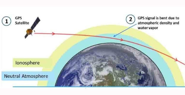
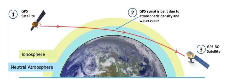
Pyxis will track GPS signals traveling through Earth’s atmosphere and convert them into dense, precise measurements of global temperature, pressure and water vapor — similar to data collected by weather balloons but on a global scale — using a technique called GPS radio occultation (GPS-RO).
Pyxis is the only GPS-RO sensor in such a small package that is powerful enough to routinely probe down into the lowest layers of the atmosphere where severe weather occurs. In addition, Pyxis is able to track signals from all four major satellite navigation systems (GPS, Galileo, Beidou and GLONASS).
PlanetiQ’s planned microsatellite constellation, with an initial set of 12 satellites launching in 2016 and 2017, will deliver more than 8 million observations per day of temperature, pressure and water vapor, or more than 10 times the amount of data available from GPS-RO sensors currently on orbit.
GPS-RO has shown the highest impact per observation on forecast accuracy among the satellite data sources ingested into computer weather models, and is particularly effective at improving predictions of high-impact weather such as hurricanes, severe weather outbreaks and winter storms. However, the amount of GPS-RO data available to date has been sparse.
The Pyxis sensor development team is based in Boulder, Colo., and led by PlanetiQ Founder Chris McCormick, who was instrumental in designing the sensors on the U.S.-Taiwan Constellation Observing System for Meteorology, Ionosphere, and Climate (COSMIC), the world’s first and only satellite constellation of proven GPS-RO sensors.
“Weather has an immense human and societal impact and affects businesses on a daily if not hourly basis, with a $9.7 trillion economic influence globally,” said Anne Hale Miglarese, president and CEO of PlanetiQ. “Improving the weather forecast and developing innovative risk analytics tools are critical to mitigate these growing costs, and the key is more high-quality weather data.”
“The Earth’s atmosphere is radically under-sampled at present especially over the oceans, which cover 70 percent of the Earth’s surface. With the speed of innovation in sensor technology, space hardware and launch, the weather forecast will dramatically change for the better in the near future,” McCormick said. “The Pyxis represents a major step forward in improving forecast accuracy for both routine weather and big storms, while leveraging the latest advances in science, technology and miniaturization to drive down costs.”
Explore further:
PlanetiQ President and CEO Anne Hale Miglarese discussed the project on The Weather Channel in August 2014.
Attila Komjathy, a NASA Jet Propulsion Laboratory principal investigator and adjunct professor in the University of New Brunswick’s Department of Geodesy and Geomatics Engineering, was named a Fellow of the Institute of Navigation in January for his work on remote sensing of the Earth’s ionosphere using signals from GNSS.
The U.S. Geological Survey (USGS) has begun production of higher level (more highly processed) Landsat data products to help advance land surface change studies. One such product is Landsat surface-reflectance data. Landsat satellite data have been produced, archived, and distributed by the U.S. Geological Survey since 1972.
Surface reflectance data products approximate what a sensor held just above the Earth’s surface would measure, if conditions were ideal without any intervening artifacts (interference or changing conditions) that may come from the Earth’s atmosphere, different levels of illumination, and the changing geometry of the view by the sensor from hundreds of miles above the Earth. The precise removal of atmospheric artifacts increases the consistency and comparability between images of the Earth’s surface taken at different times of the year and different times of the day.
Surface reflectance and other high-level data products can be requested through the USGS Earth Resources Observation and Science (EROS) Center by accessing the EROS Science Processing Architecture (ESPA) interface. Surface reflectance data are also available using the USGS EarthExplorer; select “Landsat CDR” under the tab for datasets. More information on Landsat surface reflectance data is available at the USGS Landsat website and in an updated USGS Fact Sheet.
Data users in many different fields depend on basic Earth observation information from the USGS to conduct broad investigations of historical land surface change that cross large regions of the globe and span many years. Accordingly, this community of users requires consistently calibrated radiometric data that are processed to the highest standards.
Together with free live technical support provided by practicing professional land surveyors via phone, email, message board and text messaging, JAVAD GNSS is pleased to announce the release of another innovative product, RAMS, Remote Assistance and Monitoring Services for J-Field software. J-Field is the field controller software developed for the TRIUMPH-LS GNSS receiver and the VICTOR-LS field controller. RAMS is currently available to all users of J-Field, JAVAD’s powerhouse software for survey data collection, stakeout, and computations.
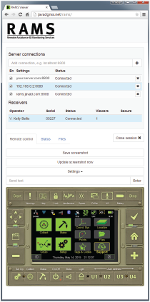
With the J-Field enabled receiver/controller connected to the Internet (via internal GSM SIM card, Wi-Fi hotspot or Ethernet), users can make their receiver/controller accessible to JAVAD’s customer support team from anywhere in the world with three button presses. “It’s like having the support person looking over the user’s shoulder,” said Shawn Billings, a surveyor from Texas.
While the TRIUMPH-LS is connected to RAMS, the user and support person share control of the receiver, giving the support person the ability to make changes to settings on the receiver or train the user remotely. “It has changed the way support is conducted, making us more efficient at determining issues and more effective in training users,” said Billings. The connection is password-protected to ensure that only those intended have remote access to the receiver.
Beyond technical support, RAMS server access is available to the user community as well. This offers the ability for project managers to remotely supervise crew efforts in the field. Because operational control of the TRIUMPH-LS/VICTOR-LS is shared between the server user and the field user, the server user (project manager) could perform the more complex operations of land surveying, such as COGO calculations and localizations, as necessary, and then allow the field user (crew member) to continue the more routine tasks of data collection.
Should the task be simpler to accomplish with office software, RAMS allows file transfer directly from the LS to the server user’s own computer and vice versa, thus enabling the project manager to easily export points, linework (dwg, dxf, shape), vectors, photos and other project-related data from the LS to his desktop. From there, he can manipulate the data in his desktop application and then copy files, with newly computed coordinates or linework, back to the LS for the crew to work with in the field. In this way, RAMS uniquely supports the obligation surveyors have to exert responsible charge over their field crews.
The full receiver control, the access to receiver files, the robust RTK features of the TRIUMPH-LS and the fully customizable collection settings in J-Field make site monitoring possible as well.
RAMS server can be accessed with almost any device with an Internet browser and Internet access. “I’ve used RAMS server to assist customers from my desktop computer, laptop, android tablet and even my cell phone,” Billings added. “Using JAVAD’s RAMS server requires no installation of software on the remote device, only an Internet connection and web browser.”
For those wanting to operate RAMS on their own server, the RAMS Server application is available from JAVAD GNSS. An Android version of RAMS Server is also available, allowing users to connect an Android device directly to the TRIUMPH-LS without the need for an Internet connection. RAMS for Android creates a local network between the Android device and the LS and allows a field user to see and manipulate J-Field with the Android device should it be necessary to work with the LS beyond the reach or view of the user.
For more information on RAMS, J-Field, TRIUMPH-LS, VICTOR-LS and other JAVAD GNSS solutions, visit www.javad.com, email [email protected] or call 408-770-1770.
Editor’s Note: This month, we introduce a column by David B. Zilkoski, one of our two new Survey Scene editors. Zilkoski has worked in the fields of geodesy and surveying for more than 40 years, including serving as director of the National Geodetic Survey. See his full bio at the end of this article. He is joined by coeditor David Doyle, who contributed the May column.
The Three Types of Heights Involved in Computing GNSS-Derived Orthometric Heights
By David B. Zilkoski
David B. Zilkoski
This column is the first in a series of newsletters discussing issues associated with establishing orthometric heights using GNSS. The purpose of my columns is not to promote a particular procedure or process, but to provide the reader with information and analysis tools to consider when using GNSS to estimate orthometric heights.
This information is not new. During the past two decades, I have written several articles and papers on estimating GNSS-derived orthometric heights and presented numerous seminars describing guidelines on how to estimate GNSS-derived heights. However, due to the automation of technology and “blackbox” processes, many users are accepting results without performing the proper analysis to ensure that their results are reasonable and correct. These processes and procedures are not difficult to perform, but they can be very beneficial to obtaining an understanding of the accuracy of your results and ensuring your results are correct.
To understand how to estimate GNSS-derived orthometric heights at centimeter-level accuracy, you must have a basic understanding of the types of heights involved, how these heights are defined and related and how accurately these heights can be determined. In other words, you need to obtain a basic understanding of ellipsoid, geoid and orthometric heights and how they are related and their estimated accuracies.
To adequately address these topics, a series of Survey Scene newsletters will be separated into several sections. Some of this material will be a review (and probably boring) for those of you that have been performing GNSS-derived orthometric height surveys but, hopefully, you will gain a little benefit from the review. For those of you just starting out, I hope this will whet your appetite to obtain a better understanding of heights.
The following is a brief outline of what the columns will address:
Description of the three types of heights involved in computing GNSS-derived orthometric heights. That is, the definition of ellipsoid, geoid and orthometric heights, and how they are related. The user should understand what potential issues can arise due to how each height was defined, modeled and published. For example, in the United States, what errors exist in the published NAVD88 heights due to the leveling network design and remaining systematic errors in the leveling data? Constraining a North American Vertical Datum of 1988 (NAVD 88) published height that’s less accurate than your GNSS-derived orthometric height may allow your results to be consistent with the surrounding published heights, but could be distorting the rest of your results. In the end, you may need to do that, but you should know how your decision has influenced the rest of your results. I was the NAVD 88 project manager, so I know where all the problems are hidden. I am just kidding about knowing where all the problems are hidden, but there are issues associated with performing a nationwide network adjustment. NGS’ latest scientific geoid models can be useful in identifying potential issues in NAVD88.
Basic procedures for detecting published NAD 83 (2011) ellipsoid height outliers and how repeatability does not mean accuracy. Why you can’t assume that the published ellipsoid heights between two closely spaced stations is accurate to the published formal errors.
A description of the differences between a scientific gravimetric geoid model and a hybrid geoid model, and why it is important to use both geoid models in your analysis. The latest NGS hybrid geoid model, Geoid12B, is made consistent with the published NAVD 88 heights. This means you will be consistent with NAVD 88 when using GEOID12B to estimate GNSS-derived orthometric heights. However, this doesn’t guarantee that your GNSS-derived orthometric heights are accurate. NGS’s new beta experimental geoid height model xGEOID14B is not distorted to fit the published NAVD 88 heights, so it is useful for identifying valid NAVD 88 benchmarks.
Basic procedures for validating NAVD 88 height constraints used to estimate GNSS-derived orthometric heights. How to ensure your monuments haven’t moved since their last survey, and how good are your leveling-derived orthometric height constraints? Based on all available information and data, basic procedures to determine how good the final set of GNSS-derived orthometric heights really are. NGS 59 guidelines outline basic rules and procedures that need to be adhered to for computing accurate NAVD 88 GNSS-derived orthometric heights.
A description of NGS’ proposed 2022 Vertical Reference Frame and why it will be a good replacement for NAVD 88.
Background
Since 1983, NOAA’s National Geodetic Survey (NGS) has performed control survey projects in the United States using GPS satellites. NGS used these early GPS surveys projects to develop guidelines and procedures to estimate GPS-derived orthometric heights. These publications are known as NGS 58 and NGS 59.
Over the past three decades, GNSS surveying techniques have proven to be so efficient and accurate that they are now routinely used in place of classical line-of-sight surveying methods for establishing vertical control networks at the 2-cm level. Understandably, interest has been growing in using GNSS techniques to replace all leveling requirements. During the next decade, scientists will continue to develop better models and tools to facilitate GNSS-derived orthometric heights replacing classical line-of-sight surveying for many applications. In the meantime, it is important to have a clear understanding of the basic concepts of establishing GNSS-derived orthometric heights, otherwise water (or something worse) may not flow “down hill.”
Let’s start with a review of the three types of heights used when estimating GNSS-derived orthometric heights and how they are related.
Types of Heights and Their Relationship
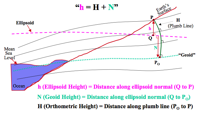
Orthometric heights (H) are referenced to an equipotential reference surface, e.g., the geoid. The orthometric height of a point on the Earth’s surface is the distance from the geoidal reference surface to the point, measured along the plumb line normal to the geoid. These are the heights most surveyors have worked with in the past and are often called mean sea-level heights.
Ellipsoid heights (h) are referenced to a reference ellipsoid. The ellipsoid height of a point is the distance from the reference ellipsoid to the point, measured along the line that is normal to the ellipsoid. Years ago, the term ellipsoid height may have been a new concept to many traditional surveyors, but prevalent today because ellipsoid heights are readily derived from GNSS measurements.
At the same point on the surface of the Earth, the difference between an ellipsoid height and an orthometric height is defined as the geoid height (N). It should be noted that h=H+N is an approximate equation because H is measured along the plumb line normal to the geoid, where h is measured along a line normal to the ellipsoid (see Figure 1). For all practical survey projects, this small difference can be ignored.
Figure 1. Relationship of ellipsoid, geoid and orthometric heights.(Figure from POB article by David Zilkoski, The GPS Observer column, Feb. 28, 2001)
Several error sources that affect the accuracy of orthometric, ellipsoid and geoid height values are generally common to nearby points. Because these error sources are in common, the uncertainty of height differences between nearby points is significantly smaller than the uncertainty of the absolute heights of each point. This is the key to establishing accurate orthometric heights using GNSS.
Orthometric height differences (dH) can then be obtained from ellipsoid height differences (dh) by subtracting the geoid height differences (dN):
dH = dh – dN
Each of these heights and height differences have systematic errors that are accounted for by following appropriate procedures during data acquisition, by applying corrections based on environmental conditions and models, and/or estimating parameters using adjustment techniques. There will always be remaining errors that are not accounted for, and you must perform the appropriate procedures to detect, reduce or eliminate these errors in the final set of GNSS-derived orthometric heights.
Relative Accuracy Estimates
Adhering to NGS guidelines (NGS 58), ellipsoid height differences (dh) over short baselines (less than 10 km) can now be determined with 2 sigma uncertainties that are typically better than +/ 2 cm. The requirement that each baseline must be repeated and agree to within 2 cm of each other, and they must be repeated on two separate days, during different times of the day, should provide a final GNSS-derived ellipsoid height better than 2 cm at the 2-sigma level. The requirement that spacing between local network stations cannot exceed 10 km helps to keep the relative error in geoid height small.
Adding in the small error for the uncertainty of the geoid height difference and controlling the remaining systematic differences between the three height systems will produce a GNSS-derived orthometric height with 2-sigma uncertainties that are typically +/- 2 cm. Therefore, it is possible to establish GNSS-derived orthometric heights to meet certain standards, not millimeter standards, but 2-cm (95%) standards are routinely met now using GNSS.
When high-accuracy field procedures are used, orthometric height differences can be computed from measurements of precise geodetic leveling with an uncertainty of less than 1 cm over a 50 kilometer distance. Less accurate results are achieved when third-order leveling methods are employed. Depending on the accuracy requirements, GNSS surveys and present high-resolution geoid models can be employed as an alternative to classical leveling methods.
In the past, the primary limiting factor was the accuracy of estimating geoid height differences. With the computation of the more accurate National high-resolution geoid models, e.g., GEOID12A, the limiting factor is ensuring that the NAVD 88 orthometric height values used to control the project are valid. Strategically occupying benchmarks with GNSS that have valid NAVD 88 height values is critical to detecting, reducing or eliminating blunders and systematic errors between the three height systems. (Note: Valid NAVD 88 height values include, but are not limited to, the following: benchmarks that have not moved since their heights were last determined, were not misidentified, and are consistent with NAVD 88.)
Conclusion
This newsletter addressed the basic concepts of GPS-derived heights. To reiterate, it is important that you understand there are three types of heights involved with estimating GNSS-derived heights: ellipsoid, geoid and orthometric. Each of these heights has its own error sources that need to be detected, reduced or eliminated by following specific procedures or applying special models. This series of newsletter columns will address these potential errors sources and provide procedures to assist you in identifying these errors.
My next column in this series, coming in the August Survey Scene, will review guidelines for detecting, reducing or eliminating error sources in ellipsoid heights, and provide a brief discussion on using published NAD 83 (2011) ellipsoid heights in your analysis.
References
NOAA Technical Memorandum NOS NGS-58, Guidelines for Establishing GPS-derived Ellipsoidal Heights (Standards: 2 cm and 5 cm), Version 4.3.
NOAA Technical Memorandum NOS NGS-59, Guidelines for Establishing GPS-derived Orthometric Heights (Standards: 2 cm and 5 cm), are available. These guidelines address the establishment and densification of vertical control networks through the use of GPS surveys and valid NAVD 88 orthometric control.
David B. Zilkoski has worked in the fields of geodesy and surveying for more than 40 years. He was employed by National Geodetic Survey (NGS) from 1974 to 2009. He served as NGS director from October 2005 to January 2009. During his career with NGS, he conducted applied GPS research to evaluate and develop guidelines for using new technology to generate geospatial products. Based on instrument testing, he developed and verified new specifications and procedures to estimate classically derived, as well as GPS-derived, orthometric heights.
Now retired from government service, as a consultant he provides technical guidance on GNSS surveys; computes crustal movement rates using GPS and leveling data; and leads training sessions on guidelines for estimating GPS-derived heights, procedures for performing leveling network adjustments, the use of ArcGIS for analyses of adjustment data and results, and the proper procedures to follow when estimating crustal movement rates using geodetic leveling data.
If you are a professional land surveyor, we’d like to hear from you! Send us a brief account of how you use GNSS in your surveying work, what tips and tricks you can share with other surveyors, and what other hardware and software you are combining with GNSS to get the job done.
Submit around 300 words, although you can certainly go longer if you wish. Five winners will be chosen from the submissions received at [email protected]; winners will be chosen on the basis of clarity, liveliness, and, in some small measure, the unusual nature of the surveying tasks you perform or the way you go about them. Winners will receive $100 gift cards.
But we’re interested in hearing about straight run-of-the-mill jobs, too! Send your entries to [email protected]. Some entries may also be chosen for further development into articles for this newsletter, or GPS World magazine, or other publishing opportunities.
Esri has unveiled a Human Health and Climate Change App Challenge, calling on the worldwide GIS community to create apps that help communities visualize, understand and combat the health impacts of climate change. Esri will award three winners more than $15,000 in cash prizes or the equivalent in software. The deadline to enter is August 14.
The app challenge is part of Esri’s comprehensive effort in support of the White House Climate Data Initiative under President Obama’s Climate Action Plan. “Esri is committed to helping communities work smarter and more efficiently to become more livable and, as a result, more resilient to climate change,” said Esri president Jack Dangermond.
Participants are encouraged to create apps using Esri’s ArcGIS platform that provide decision-making support for health professionals and empower the public to take action. Apps should help private and public organizations combine open data to gain new insights into the impacts of climate change on health.
“Understanding the geography of climate change is critical to mitigating its health effects and creating a vibrant and sustainable future,” said Este Geraghty, Esri chief medical officer.
The app challenge is open to everyone — including developers, start-ups, governments, academics and nongovernmental organizations. Participants are encouraged to use the growing pool of open data and Esri apps, maps, services and APIs to develop their app.
Judges will select the top three apps to be highlighted at the Esri Health and Human Services GIS Conference in September. In addition to awarding prizes, Esri will feature the winning apps on its collaborative resource portal.
Hackathons have captured the imagination and participation of coders around the world. But there has yet to be a geospatial intelligence-focused hackathon. The United States Geospatial Intelligence Foundation (USGIF), along with its partners and sponsors, will offer coders, data scientists and thought leaders the first-ever GEOINT Hackathon Friday, June 12, through Sunday, June 14, at its offices in Herndon, Va. Individuals and teams will partner, program and pitch solutions as they compete for a $15,000 prize.
There is no cost to register for the GEOINT Hackathon. Just visit connect.usgif.org, create an account, and select “Upcoming Events” from the sidebar menu. The “USGIF Hackathon” is listed at the bottom of this page. Full details are available here.
GEOINT Hackathon participants will be challenged to create an open-source solution within a roughly 40-hour timeframe of Friday evening to Sunday afternoon. This is a GEOINT hack, so location matters. The geography of interest and specific hack goal will be announced Friday evening during the 6 p.m. kick-off briefing.
USGIF provides this hint: “We are more interested in fostering collaboration than creating apps. All collaboration-centric coders are encouraged to sign up. The winning team will not only receive the cash prize but also passes to attend GEOINT Foreword and the GEOINT Symposium, where they will have the opportunity to meet and mingle with industry, government, and academic leaders.”
“This is a fabulous opportunity for our global GEOINT Community to continue the ongoing process of reinventing itself and opening its doors to collaboration and transparency,” said Darryl Murdock, USGIF vice president of professional development. “It is also a super venue for trying things we never before thought possible.”
USGIF, OGSystems, DigitalGlobe, Esri and the National Geospatial-Intelligence Agency (NGA) are sponsoring and supporting the event through donations, infrastructure support and judges.
This is intended to be the first in a series of GEOINT-focused hackathons. USGIF plans to hold another hackathon during GEOINT Community Week in November.
Intergraph Security, Government and Infrastructure (SG&I) has unveiled I/Map Editor for ArcGIS, a product that works directly with Esri’s ArcGIS Platform to migrate geospatial data into Intergraph’s Computer-Aided Dispatch software (I/CAD), creating greater efficiencies for users of both systems.
Also, SG&I has established Studio One, a user experience design and development lab that provides space for multi-disciplinary teams to collaborate on innovative, user-centered products and solutions.
I/Map Editor for ArcGIS brings advanced mapping features to Intergraph’s map build environment, automating and streamlining map creation in I/CAD. I/Map Editor for ArcGIS is designed to minimize the number of different systems and steps required for ArcGIS users, offering them a one-stop shop for uploading data into their I/CAD system.
‘I/Map Editor for ArcGIS enables ArcGIS users to more efficiently get their GIS data into I/CAD using tools familiar to them,” said Kalyn Sims, chief technology officer, Intergraph SG&I. “It also provides them with the ability to more frequently update their data, which benefits agencies and the public they serve. Our goal is to provide public safety organizations with the most up-to-date geospatial data possible within their first responder systems.”
Intergraph’s industry-leading I/CAD system is critical to public safety operations, enabling agencies to quickly answer emergency and non-emergency calls, create and update incidents and manage multiple resources in real time. Intergraph’s I/Map Editor products facilitate the use of GIS data as the source of mapping information in I/CAD.
Built on Intergraph’s GeoMedia, I/Map Editor permits the use of GIS data from third-party systems as the source of map graphics in I/CAD. Built on ArcGIS, the new I/Map Editor for ArcGIS enables I/CAD map production within ArcGIS. An extension hosted in ArcMap, it natively connects to Esri data sources.
In March, Intergraph and Esri announced collaborative efforts to enhance geospatial capabilities for public safety and security agencies. Through the collaboration, the companies have been working together to more tightly align Intergraph’s I/CAD software and Esri’s ArcGIS Platform.
Studio One. Located at Intergraph SG&I’s headquarters, Studio One is an extension of the company’s strategic efforts to ensure its products are built to meet the needs of users, some of whom are in high-pressure environments.
“The methodologies and technologies of UX (user experience) are maturing very quickly. For example, now we can accurately assess whether software raises or lowers stress,” said Amy Hawkins, UX team manager, Intergraph SG&I. “As we move information technology closer and closer to users, in the form of mobile and wearable devices, we need to be very sure that we are making people’s jobs easier, not harder. That’s why we established Studio One.”
Comprised of a distributed group of user researchers, designers, technical architects and functional designers, Intergraph SG&I’s UX team conducts customer site visits, ethnographic observation, interviews and surveys to understand customer workflows and environments. The UX team has traveled to multiple cities across the U.S., visiting a dozen different public safety agencies in four different metropolitan areas. In the Denver area, the team conducted approximately 47 ride-alongs with police, firefighters and emergency medical services personnel.
The UX team works with product development teams to build usage metrics collection into Intergraph SG&I’s products so that strategists and design and development teams have the best possible data on which to base product direction decisions. The team also works with research groups at universities such as Georgia Tech, Vanderbilt and the University of Alabama in Huntsville to get independent perspectives on user mental models and emerging technologies.
“By working directly with users, we get a clear understanding of how to meet customer needs now and in the future as new technologies and challenges emerge,” Hawkins said. “Our customers are in the business of providing important public services. Studio One is all about, helping people help people.”
Intergraph SG&I’s UX team will meet with customers for UX assessments during HxGN LIVE, Hexagon’s annual international user conference, in Las Vegas from June 1-4.
 On the day of the solstice, June 21, geospatial professionals around the world and members of Land Surveyors United (a global support network for land surveyors) will be simultaneously recording survey-grade GPS data from thousands of points around the globe, to gain a more accurate understanding of the earth’s surface.