TerraGo Edge 3.6 is now available. TerraGo Edge 3.6 features enhanced support for high-accuracy GPS receivers on both iOS and Android, as well as a host of new mapping features, basemap sources and integration with Google Earth.
“TerraGo Edge’s enhanced support for EOS and SXBlue receivers helps users take advantage of real-time, high-precision GPS receivers while getting all the productivity benefits that come with the smartphone and tablet user experience,” said Brian Mickel, technical consultant, LHNav. “This is the future of GPS data collection where mobile users can integrate independent GPS receivers to get whatever level of accuracy the job requires.”
New features in version 3.6 include:
Sub-meter and cm precision with SXBlue and EOS GPS receivers for iOS and Android
Polygon and polyline note support added on iPhone and Android
Auto-drawing polygons and polylines from GPS points
Multi-note view on iPhone and Android
KML import and export added to growing list of data interfaces, improves Google Earth integration
New mapping features and editing of polygon notes
New “over-zoom” feature allows extreme map zooming on all devices and basemaps
Brand new basemap source options
TerraGo Edge is an open GPS data collection solution, helping customers replace outdated handhelds and proprietary databases with an open, modern, mobile solution that meets the needs of all stakeholders. For the field users, TerraGo Edge delivers any level of precision with unparalleled support for a full range of Bluetooth GPS receivers on Android and iOS.
For the manager, TerraGo Edge provides a real-time dashboard for monitoring field users and data collection. For GIS users, TerraGo Edge provides accuracy settings that ensure GPS data quality, with tools for QA and open export to any GIS or CAD system.
A free trial of the TerraGo Edge app for iOS or Android is available.
The latest version of the TerraGo Edge includes enhanced polygon and polyline capabilities, enriched mapping features, expanded GPS receiver integration and adds KML import and export formats. View the video above for an on-demand demo of the latest features in TerraGo Edge v3.6.
The latest version of the TerraGo Edge includes enhanced polygon and polyline capabilities, enriched mapping features, expanded GPS receiver integration and adds KML import and export formats. View the video above for an on-demand demo of the latest features in TerraGo Edge v3.6.
SimActive Inc., developer of photogrammetry software, has purchased the Correlator3D software by Altoa from French Guiana. The software will be used to process images and lidar data for the production of orthomosaics.
“Following our recent acquisition of two digital cameras including the Phase One color and infrared, we needed precise, powerful, and versatile photogrammetric software,” said Walid Mostafa, manager of Altoa. “After analyzing the available tools, we decided to choose Correlator3D.”
“We are pleased to see an important company in South America such as Altoa adopt Correlator3D,” said Philippe Simard, president of SimActive. “Their use of Correlator3D demonstrates the software’s ability to adapt to different production environments and to integrate a lidar sensor with a camera.”
For a live demonstration at Commercial Unmanned Show Asia 2015 (June 30-July 1, Singapore), visit booth B10 or send an email to [email protected].
Telit Wireless Solutionsand Agnik are collaborating on Internet of Things (IoT) applications and Big Data analytics for connected devices in the auto, home and health industries. Agnik’s solutions expand the quality and quantity of integrated IoT apps and analytics available to customers and ecosystem partners of the industry-leading deviceWISE AEP.
The rapid proliferation of smart devices and products makes it challenging to aggregate and manage all these different data sources and also requires that this trove of data is harnessed and analyzed to extract valuable insights that help companies make more informed business decisions. The Internet of Things is already starting to transform businesses around the world. For example, in the automotive industry Big Data analytics provide a better understanding of vehicle performance, automotive business, automotive risk management, and connect with customers at a deeper level to improve efficiency and brand-loyalty. In the home, Big Data solutions are helping to manage energy consumption, maintain security while allowing entry to repair services while the homeowner is away. Individuals are wearing quasi healthcare devices on their bodies night and day.
Telit and Agnik are providing technology and analytics designed to make it easy for large and small companies to get onboard with the Internet of Things — reducing cost, time-to-market, complexity and risk versus trying to engineer a fragmented solution in house. At the core sits Telit’s Cloud-based deviceWISE, an application enablement platform for data acquisition, data and device management and data integration. In turn, Agnik converts the data from thousands of connected things into actionable business intelligence, delivered on custom web-based and mobile apps, and dashboards.
“We are honored to welcome Agnik as a deviceWISE business partner. Agnik’s leading IoT apps and Big Data Analytics further expand the number of off-the-shelf deviceWISE Ready solutions that are available to customers, MNOs and partners worldwide,” said Gideon Rogovsky, SVP, sales and marketing of deviceWISE platform at Telit. “Telit is creating a growing ecosystem of world-class IoT solution providers — ranging from the device side to applications and analytics.”
“We are pleased to collaborate with Telit and offer Agnik’s analytics-driven ecosystem of products and services to the deviceWISE AEP community,” said Hillol Kargupta, president of Agnik. “Agnik offers a comprehensive analytics platform for connected devices powered by our patented, onboard data-stream mining technology and wide range of distributed cloud-based analytics for consumer and commercial applications in connected environments.”
Agnik’s suite of analytics software products provide a wide range of powerful onboard and cloud-based tools that transform data about vehicle performance and user experience into valuable insights, according to the company. The analytics help companies in the automotive industry connect with car owners at a deeper level.
Agnik has also embarked upon a deep analytics driven path in the connected world of devices and products for industrial environments, home and health. Its collaboration with Telit will blend Agnik’s predictive data analytics capabilities with Telit’s device management infrastructure to develop a patchwork of insights into a holistic quilt of knowledge, from what would appear to be on the surface unrelated sources of information, devices, and products.
Defense and security company Saab and DigitalGlobe Inc., a global provider of high-resolution earth imagery solutions, have created the joint venture Vricon Inc. to produce photo-realistic 3D products and digital elevation models for enterprise and government geospatial markets.
Vricon combines Saab’s 3D technology and know-how with DigitalGlobe’s archive, which contains billions of square kilometers of high-quality commercial satellite imagery. Together, the Vricon joint venture will establish high-scale production capabilities that will make highly accurate photo-realistic 3D products and elevation data of the earth accessible via its visualization platform and standard- based data formats.
Vricon serves the entire professional geospatial market, with an initial focus on defense, security, and infrastructure. Vricon’s technology enables imagery content to accurately represent all visible objects on the earth in 3D, and its products provide customers with value and utility, superior coverage relative to aerial-derived elevation models, and superior fidelity and availability relative to other satellite-derived models.
DigitalGlobe and Saab will combine their strengths to both support and own Vricon. Under the agreement, Vricon will be headquartered in Reston, Va., with ownership set up as 50 percent DigitalGlobe and 50 percent Saab. “Our customers will benefit from global access to geospatial data of unprecedented quality. It is a win-win situation with long-term value creation for both parent companies, which will give us a market position ahead of competition,” said Magnus Brege, Vricon CEO.
“By combining DigitalGlobe’s unrivaled imagery archive with Saab’s leading edge technology, we will deliver the globe in 3D at a scale never before possible,” said Jeffrey R. Tarr, DigitalGlobe President and Chief Executive Officer. “By delivering this breakthrough product to our customers, this collaboration will drive growth and shareowner value creation.”
“The establishment of Vricon is another great example of Saab’s ability to leverage innovation and transform it into business value,” said Dan Jangblad, head of Saab business area Industrial Products and Services. “Together with DigitalGlobe, we are taking our revolutionary new 3D technology and applying it to benefit our global customer base. At the same time, we also take another step forward on our long-term path for growth in the United States.”
Top national security officials and authors will be delivering keynote addresses at the GEOINT 2015 Symposium, sponsored by the United States Geospatial Intelligence Foundation (USGIF).
USGIF’s GEOINT Symposium is the largest intelligence event in the U.S., uniting the defense, intelligence, and homeland security communities for a week of knowledge sharing, discussion, training and education, technology demonstrations, business opportunities and networking. The GEOINT 2015 Symposium will be held June 22-25 at the Walter E. Washington Convention Center in Washington, D.C.
Confirmed keynotes for GEOINT 2015 include:
Robert Cardillo, director of the National Geospatial-Intelligence Agency, became the sixth NGA Director in October 2014. He leads the agency under the authorities of the Secretary of Defense and ODNI. He was previously the first Deputy Director for Intelligence Integration at ODNI, working alongside Clapper.
James R. Clapper, director of National Intelligence, was sworn in as the fourth Director of National Intelligence (DNI) in August 2010. As DNI, Clapper leads the Intelligence Community and serves as the principal intelligence advisor to the president.
Robert D. Kaplan is a bestselling author of 15 books on foreign affairs and travel. He is currently a senior fellow at the Center for a New American Security and a contributing editor at The Atlantic. One of his most well-known books is “The Revenge of Geography: What the Map Tells Us About Coming Conflicts and the Battle Against Fate.”
Marcel Lettre was recently named Acting Under Secretary of Defense for Intelligence, serving as the principal intelligence advisor to the Secretary of Defense. He previously served as Principal Deputy Under Secretary of Defense for Intelligence.
Michael D. Lumpkin is the Assistant Secretary of Defense for Special Operations and Low-Intensity Conflict. He has more than 20 years of active duty military service as a U.S. Navy SEAL as well as significant experience in the private sector.
Gen. Stan McChrystal, a retired four-star general, was commander of the U.S. and International Security Assistance Forces in Afghanistan as well as former commander of the Joint Special Operations Command. He is also co-founder of the McChrystal Group and recently published the book “Team of Teams: New Rules of Engagement for a Complex World.
Adam Schiff represents California’s 28th Congressional District and is the ranking member of the House Permanent Select Committee on Intelligence. He is also a member of the Benghazi Select Committee.
Kaplan and McChrystal’s books will be on sale throughout the week at GEOINT 2015. Both authors will sign copies of their books directly following their respective keynote addresses.
Both Cardillo and Clapper have spoken at past GEOINT Symposia, while this is Kaplan, Lettre, Lumpkin, McChrystal and Schiff’s first speaking engagement with USGIF. Visit GEOINTv.com to view videos from the GEOINT 2013* Symposium, including keynote addresses by Clapper and Cardillo.
More keynotes are expected to be announced in the coming weeks. To learn more about GEOINT 2015, view the agenda, or to register for the event, visit geoint2015.com.
U.S. auto sales may drop about 40 percent in the next 25 years because of autonomous vehicles hitting the road, reports Bloomberg. In particular, shared driverless cars would force mass-market automakers such as General Motors Co. and Ford Motor Co. to slash output, a Barclays analyst told Bloomberg.
Vehicle ownership rates could be cut almost in half because many families would only need one car. However, driverless cars would travel twice as many miles as they return home between trips to ferry a different family member. As a result, automakers would have to shrink their production in order to survive.
The numbers are outlined in a new report by analyst Brian Johnson.
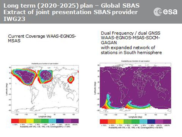
Current coverage (left) of WAAS, EGNOS and MSAS; long-term 2020–2025 (right) plan for dual-frequency, dual-GNSS WAAS-EGNOS-MSAS-SDCM-GAGAN.
SBAS Agree to Common Message
Aircraft navigation and safety will benefit from enhanced, reliable satellite navigation signals on a seamless basis across much of the world in the 2020–2025 timeframe. The 28th Satellite-based Augmentation Systems Interoperability Working Group (IWG) came to agreement on standardization of satellite-based augmentation systems (SBAS) in a meeting hosted by the European Space Agency in early April. The group planned a shift from reliance exclusively on GPS to a multi-constellation design employing Galileo, BeiDou and GLONASS after 2020.
The agreement centers around a message definition for a new secondary SBAS channel — to be known as L5, along with the current L1 — for second-generation SBAS systems, which will utilize dual-frequency multi-constellation signals, greatly increasing the accuracy of navigation systems available to airliners by largely eliminating ionospheric errors. Plans also call for an expanded network of stations in the Southern Hemisphere. The IWG document must now be accepted by the official international SBAS standardization bodies: the International Civil Aviation Organisation, the U.S. Radio Technical Commission for Aeronautics (RTCA) and the European Organisation for Civil Aviation Equipment.
The meeting also reported on the state of development of the other global SBAS systems. Along with the four operational systems — the U.S. WAAS, European EGNOS, Japan’s Multi-functional Satellite Augmentation System (MSAS) and India’s GAGAN (GPS and geo-augmented navigation system) — these comprise South Korea’s KASS, China’s Beidou SBAS, Russia’s System for Differential Corrections and Monitoring (SDCM) and the West African Agency for Aerial Navigation Safety in Africa and Madagascar (ASECNA) SBAS.
UAV Integration into Airspace
The Federal Aviation Administration (FAA) announced two new initiatives related to unmanned aircraft systems (UAS) at the Association for Unmanned Vehicle Systems International (AUVSI) Unmanned Systems 2015 conference in Atlanta, Ga., in early May.
FAA Administrator Michael Huertatold a large gathering of national journalists, “The unmanned aircraft industry is changing faster than any segment in the aircraft industry. A new project to harness that energy, the Pathfinder program, is partnering with three leading U.S. companies to expand unmanned aircraft operations in the United States.” The FAA is working with industry partners on three focus areas:
CNN will research visual line of sight (LOS) operations for newsgathering in urban areas. CNN will continue working with Georgia Tech University to improve newsgathering for all organizations.
PrecisionHawk will investigate agricultural operations for rural areas, flying outside LOS.
BNSF Railway, second-largest freight railroad network in North America, will undertake inspection of rail infrastructure, also beyond visual LOS.
Huerta said that the partners, collectively, “are trying to push the envelope, what can we accommodate safely and what can we learn from that.We’ll test a little, learn a little, then test some more. How do we see a staged implementation? To integrate unmanned aircraft, but to do it safely. We’re trying to push the edges of what we can allow, working with partners who have specific uses and resources.”
As to a timeframe to reach new UAV regulations, he replied, “I can’t comment a lot on the rule itself, but it’s fair to say that in the rulemaking comment process [closed on April 24], we received more than 4,500 comments. It’s too early to say how those comments will shape the final rulemaking.
“Assessment will be done in the coming months, perhaps by the end of the year, but that’s an aggressive timetable. That’s not accomplished in six months, nor should it take a million years.”
New Airbus EGNOS-Capable
The new Airbus A350 airliner, now entering service, comes fitted with EGNOS. The EGNOS system is being adopted by European airports to enable satellite-guided landing approaches. The A350’s Satellite Landing System allows pilots to perform precision-landing approaches guided by EGNOS or its U.S. equivalent, WAAS. The capability offers vertical landing guidance down to a minimum of 60 miles.
New Galileo Satellite on the Air
Monitoring by researchers at the German Aerospace Center (Deutsches Zentrum für Luft- und Raumfahrt, or DLR) indicates that one of the Galileo full-operational-capability (FOC) satellites launched on March 27 has begun transmitting standard L-band signals using pseudorandom-noise-code identifier 22.
The first E1 and E5 signals from GSAT0204, also known as FOC-FM4 and Galileo 8 and as NORAD object 40545, were received at an International GNSS Service Multi-GNSS Experiment tracking station in Windhoek, Namibia, at about 11:32 UTC May 21. The satellite’s signals were subsequently tracked by a station in Wettzell, Germany, and then by others.
The signals will be set unhealthy for use until satellite commissioning is completed.
News item courtesy of CANSPACE Listserv.
Euroship Gets eLoran as Backup
Container ship in port.
Ship management company EuroShip Services Ltd. has installed eLoran as a backup to GPS to ensure the safety of its vessels operating off the coast of the United Kingdom.
The trial installation may lead to implementation across the full fleet of16 vessels managed by Euroship, working routes in Northern Europe. The land-based radio navigation system is intended to seamlessly take over in the event of a GPS outage. EuroShip plans to simulate GPS outages to test eLoran provision of position, navigation and timing data automatically.
New GPS III RFP
The U.S. Air Force (USAF) has released a draft Request for Proposal for GPS III Launch Services, encompassing launch vehicle production, mission integration and launch operations.USAF reintroduces competition into the Evolved Expendable Launch Vehicle (EELV) program after more than a decade.
GPS III is the first of nine launches the Air Force intends to competebetween now and 2017, followed by 25 more from 2018 to 2022.
The OriginGPS Multi Spider module provides high sensitivity and noise immunity by incorporating its proprietary Noise Free Zone technology for faster position fix and navigation stability even under challenging satellite signal conditions.
SiRFstarV — CSR’s GNSS receiver that tracks both GPS and GLONASS satellites — has the CSR mbed Shield, which comes fitted with the OriginGPS Multi Spider module (ORG4572) requiring 1V8 supply, ground, UART interface and connection to GNSS capable antenna. Additional IOs are available for interrupts, turning the receiver on and off, reset, fix status and power mode information.
The OriginGPS Multi Spider is a tiny GPS + GLONASS module designed to support ultra-compact applications in which size is at a premium, such as smartwatches, wearable devices, trackers and digital cameras. It is a fully integrated, highly sensitive GPS + GLONASS receiver module measuring 7 x 7 x 2.1 millimeters.
The Multi Spider continuously tracks all GPS and GLONASS satellites in view and provides real-time positioning data in the standard industry format, defined by the U.S. National Marine Electronics Association (NMEA).
For more information about GPS/GNSS modules, visit OriginGPS.
The GN-87 multi-GNSS receiver by Furuno Electric Co.
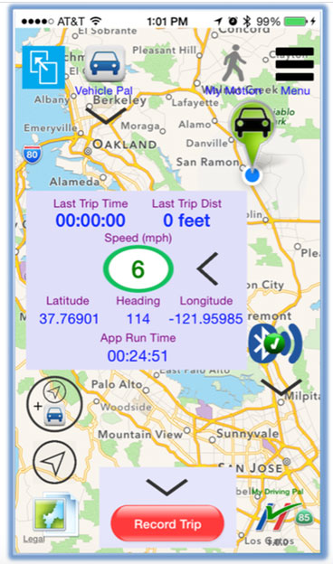
Furuno Electric Co.’s latest multi-GNSS receiver module, the GN-87, has been adopted for use in the new My Driving Pal (MDP) device.
The MDP device and app communicate with each other via Bluetooth low energy (BLE). When the MDP device and a phone running the MDP app are within range of each other (approximately 15 meters), the device keeps its internal GPS in idle mode. When the phone is out of Bluetooth range and the object that is carrying the MDP device is moving (for instance, under the seat of a stolen bicycle or in the pocket of a wandering child), the MDP device activates its built-in GNSS receiver and cellular modem, tracks the asset, and immediately notifies the user on a phone via remote push notification.
The range is unlimited, because the MDP device will track the asset anywhere in the world, with an accuracy level of meters. To protect user’s privacy, all tracking data remains locally on the phone and is not transmitted to any backend server.
In April, the GN-87 receiver was adopted for the new quadcopter Bebop Drone, made by Parrot SA. The GN-87 provides positioning accuracy and smooth ground tracking because of its multi-GNSS technology, which allows it to receive more satellite data even in harsh environments such as urban canyons.
My Driving Pal (MDP) is a technology startup based in Silicon Valley that develops advanced Internet of Things solutions. MDP’s mission is to improve road safety by enabling vehicle to vehicle and vehicle to infrastructure communications. A small percentage of new vehicles are connected, but still the vast majority have no connectivity, not including motorcycles and bicycles. The MDP product delivers a suite of security, monitoring, and tracking applications, from delivering remote notification on phone if interior temperature of car gets too high, to automatically tracking the bike, if it’s ever stolen.
For more information on the MDP device (capabilities, availability, distribution, retail or partnerships), send an email to [email protected], or follow MDP on Facebook.
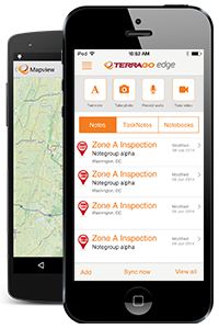 TerraGo Edge 3.6 is now available. TerraGo Edge 3.6 features enhanced support for high-accuracy GPS receivers on both iOS and Android, as well as a host of new mapping features, basemap sources and integration with Google Earth.