Geospatial Solutions’ and GPS World‘s Art Kalinski reports from eMerge Americas, held May 4-5 in Miami. RangeVideo displays its RVJET UAV (unmanned aerial vehicle) with a very flexible platform and 3D operator viewing goggles.
Blog
-
Indra Provides Real Time Data to Google Earth 3D City Maps
Geospatial Solutions’ and GPS World‘s Art Kalinski reports from eMerge Americas, held May 4-5 in Miami. Indra is a large Spanish firm in the Smart Cities program demonstrating its end to end solutions, including building 3D models overlaid on Google Earth.
-
Florida International’s Autonomous Catamaran Performs Bathymetry Data Collection, Mapping
Geospatial Solutions’ and GPS World‘s Art Kalinski reports from eMerge Americas, held May 4-5 in Miami. Florida International University had numerous technology displays, but its autonomous catamaran doing bathymetry data collection and mapping was impressive.
-
Catbird Discusses Security Oversight Software
Geospatial Solutions’ and GPS World‘s Art Kalinski reports from eMerge Americas, held May 4-5 in Miami. Catbird develops software-defined security for virtual infrastructure. Its software suite of products was designed to provide visibility into and protection of private clouds and virtual data centers, and is available for both VMware and OpenStack.
-
CartoData Builds 3D Models from UAV Data
Geospatial Solutions’ and GPS World‘s Art Kalinski reports from eMerge Americas, held May 4-5 in Miami. CartoData is a Mexican firm doing some very impressive end-to-end solutions including the use of Pix4D to build 3D models from UAV data. The company provides geographic information for public and private sectors, producing cartography and geomatics-related products and services.
-
Baptist Health Demos 3D Remote Surgery System
Geospatial Solutions’ and GPS World‘s Art Kalinski reports from eMerge Americas, held May 4-5 in Miami. Baptist Health demonstrated its 3D remote surgery system that is dimensionally scalable. These systems permit a surgeon to work at a macro level while the surgical tools operate a at microscopic level.
-
ALTA Systems Provides Alternative to Powered UAVs
ALTA is a smart balloon which flies without fuel or a pilot to up to 400 feet and is FAA compliant. It is held by a tether and transmits images and other data to any screen. ALTA services public safety, news agencies, agriculture, construction, real estate, travel and tourism.
-
Expert Advice: Low-End Jam Resilience May Not Be Desirable
Jan Wendel By Jan Wendel
At the European Navigation Conference held in Bordeaux, France, April 7–10, a keynote session and ensuing panel discussion addressed the issue of “GNSS Resilience for Terrestrial and Naval Applications.” During the discussion, two questions from the floor drew these responses from panelist Jan Wendel of Airbus Defence & Space GmbH, a leading European aerospace company.
Do you believe that receiver manufacturers will be able to deliver resilient receivers in the future?
JW: In order to achieve resilience, regulatory measures can only provide a mid- to long-term solution. Therefore, resilience needs to be addressed at the receiver level as well.
Considering spoofing, I am not aware of any confirmed spoofing incident. Iran has been claiming to have spoofed a CIA drone, which became for me at least theoretically feasible when I heard the rumor that this drone was equipped with a GPS C/A code receiver. Also, there has been a wrongly configured repeater at the Hannover airport. Nevertheless, spoofing to me does not seem to be a current threat.
However, jamming is clearly a reality nowadays. In my opinion, we should first decide which level of resilience we actually want to achieve for which type of user receiver. If the simple receivers like in smartphones become more and more robust against jamming, the simple jammers available on the Internet will react with an increasing jamming power. This will leave less margin for the receivers used in more critical applications, which we really would like to see functioning permanently.
Therefore, resilience for low-end receivers might not be a good idea; maybe it would be better to see them fail in some scenarios.
Another aspect in the discussion we have had so far is the spreading-code encryption for authentication purposes. Actually, I see spreading-code encryption more as a means to restrict the access of a GNSS signal to authorized users and as an anti-spoofing measure, but not primarily as a means for authentication. Here, we must be aware that the access is not necessarily as restricted as we would like to think.
With directive antennas, blind demodulation techniques and a communication link, it is possible with a slight delay to achieve a position, velocity and time solution at a rover, without being an authorized user of the respective service.
We must understand resilience also in a more global sense, that such a possibility must not be detrimental to the applications assuming a restricted access to specific GNSS services.
Do standards help?
JW: In general, standards are a good thing, as they help in the construction of complex systems by assuring interface compatibility and also minimum performances. However, care needs to be taken when the standards are defined. For example, in the NMEA 0183 protocol, essential information is missing that is required for integration of a GNSS receiver with an inertial navigation system, for example, vertical velocity, full variance-covariance matrices of the receiver’s position and velocity, or raw data like pseudorange, delta ranges and ephemeris to name a few. Clearly, the NMEA protocol was not designed for GNSS/INS integration, and for its intended use the NMEA protocol fits perfectly.
However, for many applications, it is not usable. Being a de-facto standard offered by most receivers, I think it would be beneficial if this protocol would follow more a general-purpose spirit, like most of the proprietary protocols of the different receiver manufacturers do. So with the NMEA protocol lacking relevant information, we are in a situation where for many applications either the receiver manufacturers’ proprietary protocols have to be used — given these protocols offer the required information — or the receiver cannot be used at all. For me, this is an example where a standard is not of great help, also because the process of developing such a standard towards an extended scope takes considerable time, if possible at all.
Jan Wendel is a system engineer at Airbus DS GmbH in Munich, Germany, where he is involved in activities related to satellite navigation, including tracking, integrity and sensor integration algorithms. He received the Dr.-Ing. degree from the University of Karlsruhe, where he is also a private lecturer.
-
Hey, AU! — Autonomous Unmanned News
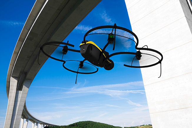
In this special section, GPS World focuses on automous positioning and navigation technology, including unmanned aerial vehicles (UAVs), unmanned aircraft systems (UAS) and unmanned ground vehicles (UGVs).
SenseFly Launches Intelligent Mapping and Inspection Drone
SenseFly launched the eXom, a quadcopter for mapping and inspection, at the AUVSI Unmanned Systems show, held May 4–7 in Atlanta.
The 3.7-pound quadcopter offers professionals such as civil engineers and land surveyors the situational awareness, imaging flexibility and durability they need for challenging tasks, senseFly said. The sensors — GPS, inertial measurement units, barometers, magnetometers and magnetic encoders — maximize stability and safety.
Septentrio Launches UAS Receiver, Software for Drones
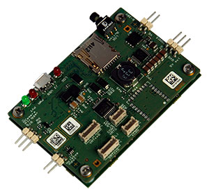
The AsteRx-m UAS by Septentrio. Septentrio has launched the AsteRx-m UAS, an RTK-accurate GNSS receiver solution specially designed for the drone market. The AsteRx-m UAS provides high-accuracy GNSS positioning with low power consumption, according to Septentrio.
The launch of the AsteRx-m UAS board is complemented by the release of GeoTagZ software suite. The GeoTagZ suite works with the UAS camera and image-processing solution to provide centimeter-accurate position tagging of images without the need for a real-time data link.
Despite being Septentrio’s smallest receiver, the AsteRx-m UAS provides consistent, robust and accurate positioning from Septentrio’s in-house GNSS+ algorithm technology. The receiver delivers cm-level accuracy at less than 600 mW with GPS and less than 700 mW with GLONASS.
Kairos Kit Makes Vehicles Unmanned
Kairos Autonomi’s Pronto4 robotic applique kit is an add-on vehicle autonomy system that provides unmanned capabilities to current manned vehicles, rendering them optionally unmanned. Pronto4 delivers the torque needed to control traction, braking, throttle and implements in heavy vehicles and equipment, as well as smarter robotic functions such as GPS path following and supervised autonomous behaviors. The kit can be installed in any heavy vehicle or machine, rendering that vehicle optionally unmanned, and the equipment can still operate manually.
Applications include government and academic research and development; military training and testing; range clearance; mining; and tactical military uses.

Kairos displayed its Pronto4 unmanned kits at May’s AUVSI show.
Exelis, FAA Test Sites to Research Safety
Exelis has signed agreements with four FAA-designated UAS test sites for airspace situational awareness and research. The research will use the Exelis Symphony RangeVue sense-and-avoid tool to aid in safe integration of unmanned aircraft into the national airspace. The test sites will gain situational awareness of the range airspace via Symphony RangeVue, while Exelis gains product feedback. Symphony RangeVue enables UAS operators to access real-time and historical surveillance information via a web-hosted platform, helping to manage mission operations across multiple locations.
FAA Names MSU as Its Center of Excellence
The FAA has selected a Mississippi State University team as its Center of Excellence for Unmanned Aircraft Systems (COE UAS). The COE will focus on research, education and training in areas critical to safe and successful integration of UAS into the nation’s airspace.
Bipartisan Bill Would Expedite Exemptions
Sen. Cory Booker (D-N.J.) and Sen. John Hoeven (R-N.D.) have introduced the Commercial UAS Modernization Act, which would set temporary rules for those who want to fly commercial unmanned aircraft systems before the FAA establishes permanent laws regarding drone use. The senators believe the U.S. is falling behind other countries when it comes to creating rules for commercial drones.
-
Official Best Practices for June 30 Leap Second Published
A leap second is scheduled to occur on June 30, and most affected industries are taking steps to prepare. Now the DHS National Coordinating Center for Communications has issued guidance with a paper titled “Best Practices for Leap Second Event Occurring on 30 June 2015.”
The paper is sponsored by the National Cybersecurity and Communications Integration Center (NCCIC) in coordination with the United States Naval Observatory, National Institute of Standards and Technology (NIST), the USCG Navigation Center, and the National Coordination Office for Space-Based Positioning, Navigation and Timing (PNT).
The paper is intended to assist federal, state and local governments and private-sector organizations prepare for the June 30 leap second event. Entities using precision time should be mindful that no leap second adjustment has occurred on a non-holiday weekday in the past decade. Of the three leap seconds implemented since 2000, two have been scheduled on December 31 and the most recent was on July 1, 2012.
The U.S. Coast Guard Navigation Center (NAVCEN) asks anyone who experiences any operational challenges relating to the leap second insertion to report it via the NAVCEN website under “Report a GPS Problem”.
In theory, on June 30, all UTC clocks should insert a second labeled 23h 59m 60s (the leap second) following one labeled 23h 59m 59s UTC. This is equivalent to having all of the clocks in the world stop for one second at that time, as explained in May’s Expert Advice column.
-
EGNOS Hits the Road in North Africa and Middle East
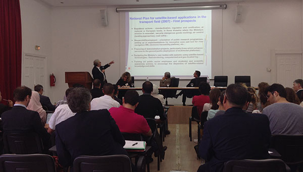
MEDUSA sponsored a Think Tank May 19 in Tunis focused on EGNOS in Intelligent Transport Systems (ITS). Delegates from 10 countries met in Tunis May 19 for an “All-day-long Think Tank” organized by MEDUSA. The sixty participants represented Algeria, Belgium, Czech Republic, Egypt, Jordan, France, Italy, Morocco, Tunisia and Slovak Republic.
Focused on the Intelligent Transport Systems (ITS) market, the event addressed the advantages of satellite navigation, and particularly of EGNOS and Galileo. ITS concerns the integration of information and communication technologies to create new applications and services for transport and mobility. ITS applies to all transport modes and is oriented to both passenger and freight transport. Satellite navigation plays an important role in ITS.
The MEDUSA Think Tank opened with a keynote speech by Ammar Habib of the Ministry of Transport of Tunisia, who reaffirmed the country’s interest in the development of ITS and in the cooperation with Europe in relation to the exploitation of the services offered by the European GNSS in the various transport domains.
The Euromed and European panelists gave a wide overview of existing and emerging applications in their countries, such as tracking and tracing of dangerous goods transportation, tracking special regulated fleets, emergency call, road tolling, urban traffic management, control of service fleets, and freight transit monitoring. They presented the existing technologies and value-added services that can be delivered through EGNOS today, and services that will become more robust thanks to Galileo in the future. It was recognized that the European GNSS, EGNOS and Galileo, can provide benefits to more than European countries and that, though primarily conceived for the aviation needs, EGNOS has interesting perspectives of utilization in ITS, and particularly in those applications requiring accurate and reliable positioning.
The participants from different sectors (policy makers, users, technology and commercial players, experts) shared their experiences and lessons learned. They also had the opportunity for networking, establishing relationships, and strengthening cooperation on GNSS and ITS.
Organized in combination with the Elgazala Innovation Days 2015, an international exhibition on information and communication technologies, the Think Tank is one of the technical assistance actions undertaken by MEDUSA and in the frame of the program of GEMCO (Galileo EuroMed Cooperation Office), the regional cooperation structure in Tunis set up and operated by MEDUSA.
About MEDUSA — MEDiterranean follow-Up for EGNOS Adoption
Coordinated by Telespazio, the MEDUSA project belongs to the Euromed GNSS program, part of the Euromed Transport framework. MEDUSA aids the Euromed countries in the operational introduction and the exploitation of the European GNSS (EGNOS/Galileo) in various applications, mainly in the transport sectors. MEDUSA runs a program of technical assistance actions, aimed at capacity building, development of enablers and regional cooperation on EGNOS/Galileo.
-
FAA’s UAS Test Sites Receive Blanket Authorizations
The nation’s six unmanned aircraft system test sites now have blanket authorizations to fly drones and no longer have to seek authorizations for each type of aircraft flown, according to new Federal Aviation Administration regulations.
The new regulations streamline the approval process for UAS research by the test sites. They also allow those with only a recreational- or sport-pilot certificate to conduct test-site operations. Previously, the rules required operators to have a private pilot’s license. A third-class medical certificate also is no longer required. Now an operator only needs a valid driver’s license to satisfy the medical requirement.
The FAA expects this improved access for the test sites will provide more opportunities for research that may help the agency integrate UAS into the nation’s airspace more quickly and easily.
Under the new regulations, drones under 55 pounds operated by test sites may fly during the day up to 200 feet above ground level anywhere in the country, except in restricted airspace or near airports and heliports.
The new Certificates of Waiver or Authorization (COAs) also let the test sites fly various types of UAS under a single COA, making it easier for them to conduct research missions. Previously, the FAA required authorization for each type of UAS the operators wanted to fly.
Brian Wynne, president and CEO of the Association of Unmanned Vehicle Systems International (AUVSI), praised the FAA announcement. “This new policy will make it easier for the test sites to perform the research needed to safely integrate UAS into the national airspace system. It is an exciting time for the unmanned aircraft systems industry and policies like this help further advance UAS innovation.”
When Wynne testified at the House Committee on Science, Space and Technology earlier in the year, he specifically called for a comprehensive industry-government UAS research plan, more resources for the federal government to coordinate UAS research and intellectual property protections for the companies that participate in UAS R&D.
According to Wynne’s take on the new policy, things are heading in the right direction. “This new policy, the Center of Excellence designation and the Pathfinder Program announced earlier this month, along with ongoing industry and government research efforts, all point to a future where the possible will become reality,” he says.
“Today’s FAA announcement is great news for the future of Nevada’s UAS Test Site effort,” says Tom Wilczek, aerospace and defense industry specialist for the Nevada Governor’s Office of Economic Development. “Nevada has been working diligently to get companies up and flying UAVs on our test sites, and the ability for us to implement public aircraft operations that fly under 200 feet … will significantly speed up the ability to test on our Nevada sites and move this emerging industry into commercial flights.”
The expanded operational parameters for the test sites are similar to those the FAA implemented in March for civil UAS operations authorized under a Section 333 exemption.
The six UAS test sites are the first public operators to receive this type of “blanket” airspace access across the United States, including Alaska and Hawaii. The sites may still fly outside the “blanket” COA parameters if they receive or retain separate COAs specific to the airspace requested for those operations.