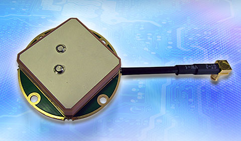
Tallysman’s compact GNSS TW1721 dual-feed embedded antenna with Accutenna technology.
Tallysman, a provider of high-performance, high-quality RF and GNSS components, has announced that its range of antennas featuring proprietary Accutenna technology is optimized for today’s multi-constellation satellite systems, including Europe’s Galileo, China’s next-generation BeiDou, GPS, GLONASS and India’s IRNSS.
Tallysman’s compact GNSS antenna range with Accutenna technology is future-proof: GNSS is changing, and an increasing number of receivers are capable of accessing multiple constellations — GPS, GLONASS, Galileo, BeiDou — but to provide the high precision these new generation of satellites enable also requires new antenna technology.
Tallysman’s proprietary Accutenna dual-feed patch technology used in the company’s wide range of GNSS antennas provides circular response over the entire antenna bandwidth, yielding superior multi-path signal rejection-low axial ratios, tight phase center variation (PCV), and a linear phase response. Single-feed patch antennas, by contrast, only provide a circular response at a single frequency and exhibit poor multipath signal rejection when receiving signals from two or more constellations. A pre-filtering option is available that gives additional protection from near out-of-band signals if required.
“Today’s wideband GNSS signals require a pure right-hand-circular response over a much wider bandwidth,” said Gyles Panther, president of Tallysman. “An inadequate phase response results in poor cross polarization suppression, which simply cannot be overcome in the GNSS receiver chip, regardless of its capabilities. Moreover, multipath interference can be expected, even in normal reception situations. Accutenna technology is a cost-effective way to ameliorate this and is particularly beneficial in situations where precision matters.”
In March, the European Space Agency launched two additional satellites (Galileo 7 and 8). Also in March, the United States launched GPS IIF-9, India launched IRNSS-1D, and China successfully launched its new generation BeiDou-3 M1. The expanding number of satellites will benefit many applications, from next-generation in-car navigation systems to coastguard search and rescue and precision agriculture, Tallysman said.
Parrot’s quadcopter Bebop Drone has Furuno inside.
Furuno Electric Co.’s latest multi-GNSS receiver module, GN-87, has been adopted for the new quadcopter Bebop Drone, made by Parrot SA. Parrot develops advanced technology wireless products.
The GN-87 can receive GPS, GLONASS, SBAS, and QZSS concurrently, which significantly improves positioning success rate and robustness against interferences by using different frequency bands, Furuno said.
Parrot Bebop Drone, equipped with a 14-megapixel fisheye lens camera, takes video and pictures in a 180-degree field. The drone integrates mechanical and digital systems, like shock absorbers that cushion engine vibrations and algorithms for an exclusive 3-axis image stabilization, meaning that the angle of the view remains fixed, without distortion, regardless of the inclination of the drone and movement caused by turbulence. The combination of numerous sensors gives the drone impressive stability and great maneuverability when piloted via Wi-Fi with a smartphone and a tablet, or with its Wi-Fi extender, Parrot Skycontroller.
Furuno’s GN-87 supports sensing for autonomous flying according to flight routes preset on the map application by user, automatic return to takeoff position, recording flight path data for 3D modeling on Parrot Academy map. According to Parrot, selecting Furuno’s GN-87 multi-GNSS receiver module enabled simple integration with a high-performance GNSS receiver module while guaranteeing high quality and high volume supply availability.
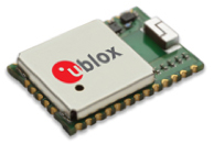
u-blox is offering the CAM-M8C — a small, low-profile GNSS positioning module with an integrated wideband chip antenna for reception across the entire L1 band. The module offers simultaneous GNSS operation for GPS/GLONASS, GPS/BeiDou, or GLONASS/BeiDou to deliver accurate, jamming-resistant and reliable positioning anywhere in the world.
The CAM-M8C integrates a u-blox M8 satellite receiver, crystal oscillator, SAW filter and low-noise amplifier. It also has an input for an external active antenna — when using this option, the internal antenna acts as a backup. Because of its design, the module maintains its performance regardless of physical orientation, making the product suitable for mobile applications with frequent change of bearing.
“Where space is at a premium, for example in emergency call systems, in handheld navigation or in wearable devices, the CAM-M8C module offers a very cost-effective way to bring products to market quickly due to its small size and high levels of integration,” said Kim Kaisti, product manager, Product Center Positioning. “It does this without compromising performance or reliability, and leaves system designers free to concentrate on other important aspects of their product development.”
The CAM-M8C is footprint-compatible with u-blox UC530 and UC530M modules, providing an easy upgrade path, the company said. The module is available now.
To further accelerate design and development, an evaluation kit, EVK-M8CCAM, provides a way to become familiar with the CAM-M8C module and assess its performance in specific applications.
The u-blox M8 GNSS receiver antenna module is delivered in u-blox Professional Grade, and is qualified to JEDS47 and ISO16750 standard “Road vehicles – Environmental conditions and testing for electrical and electronic equipment.” The product is manufactured in ISO/TS 16949 automotive-certified production sites, ensuring the high quality and reliability
NASA and the U.S. Geological Survey have started work on Landsat 9, an upgraded rebuild of the Landsat 8 spacecraft launched in 2013, to extend the Landsat program’s decades-long observations of Earth’s land cover. (Image Credit: NASA)
News from NASA.
NASA and the U.S. Geological Survey (USGS) have started work on Landsat 9, planned to launch in 2023, which will extend the Earth-observing program’s record of land images to half a century.
The Landsat program has provided accurate measurements of Earth’s land cover since 1972. With data from Landsat satellites, ecologists have tracked deforestation in South America, water managers have monitored irrigation of farmland in the American West, and researchers have watched the growth of cities worldwide. With the help of the program’s open archive, firefighters have assessed the severity of wildfires and scientists have mapped the retreat of mountain glaciers.
The president’s fiscal year 2016 budget calls for initiation of a Landsat 9 spacecraft as an upgraded rebuild of Landsat 8, as well as development of a low-cost thermal infrared (TIR) free-flying satellite for launch in 2019 to reduce the risk of a data gap in this important measurement. The TIR free flyer will ensure data continuity by flying in formation with Landsat 8. The budget also calls for the exploration of technology and systems innovations to provide more cost effective and advanced capabilities in future land-imaging missions beyond Landsat 9, such as finding ways to miniaturize instruments to be launched on smaller, less expensive satellites.
“Moving out on Landsat 9 is a high priority for NASA and USGS as part of a sustainable land imaging program that will serve the nation into the future as the current Landsat program has done for decades,” said John Grunsfeld, associate administrator for science at NASA Headquarters, Washington. “Continuing the critical observations made by the Landsat satellites is important now and their value will only grow in the future, given the long term environmental changes we are seeing on planet Earth.”
Because an important part of the land imaging program is to provide consistent long-term observations, this mission will largely replicate its predecessor Landsat 8. The mission will carry two instruments, one that captures views of the planet in visible, near infrared and shortwave-infrared light, and another that measures the thermal infrared radiation, or heat, of Earth’s surfaces. These instruments have sensors with moderate resolution and the ability to detect more variation in intensity than the first seven satellites in the Landsat program.
The Landsat 9 mission is a partnership between NASA and the USGS. NASA will build, launch, perform the initial check-out and commissioning of the satellite; USGS will operate Landsat 9 and process, archive, and freely distribute the mission’s data.
“Landsat is a remarkably successful partnership,” said Sarah Ryker, USGS deputy associate director for climate and land use change, Reston, Virginia. “Last year the White House found that GPS, weather satellites, and Landsat are the three most critical types of Earth-orbiting assets for civil applications, because they’re used by many economic sectors and fields of research. Having Landsat 9 in progress, and a long-term commitment to sustainable land imaging, is great for natural resource science and for data-driven industries such as precision agriculture and insurance.”
NASA’s Goddard Space Flight Center in Greenbelt, Md., will lead development of the Landsat 9 flight segment. Goddard will also build the Thermal Infrared Sensor (TIRS), which will be similar to the TIRS that the center built for Landsat 8. The new improved TIRS will have a five-year design lifetime, compared to the three-year design lifetime of the sensor on Landsat 8.
“This is good news for Goddard, and it’s great news for the Landsat community to get the next mission going,” said Del Jenstrom, the Landsat 9 project manager at NASA Goddard. “It will provide data consistent with, or better than, Landsat 8.”
With decades of observations, scientists can tease out subtle changes in ecosystems, the effects of climate change on permafrost, changes in farming technologies, and many other activities that alter the landscape.
“With a launch in 2023, Landsat 9 would propel the program past 50 years of collecting global land cover data,” said Jeffrey Masek, Landsat 9 Project Scientist at Goddard. “That’s the hallmark of Landsat: the longer the satellites view the Earth, the more phenomena you can observe and understand. We see changing areas of irrigated agriculture worldwide, systemic conversion of forest to pasture — activities where either human pressures or natural environmental pressures are causing the shifts in land use over decades.”
“We have recognized for the first time that we’re not just going to do one more, then stop, but that Landsat is actually a long-term monitoring activity, like the weather satellites, that should go on in perpetuity,” Masek said.
NASA uses the vantage point of space to increase our understanding of our home planet, improve lives, and safeguard our future. NASA develops new ways to observe and study Earth’s interconnected natural systems with long-term data records. The agency freely shares this unique knowledge and works with institutions around the world to gain new insights into how our planet is changing.
Ford Motor Company and Telogis have expanded their exclusive partnership to bring Ford Telematics powered by Telogis to Ford’s commercial customers in the United Kingdom first, with other European markets to follow later this summer. Ford Telematics uses real-time information from Ford vehicles to enable businesses with workers in the field to have insight into vehicle location, driver behavior and fuel consumption.
The telematics can save companies up to 20 percent on fuel, according to a 2012 Frost & Sullivan report.
Since 2011, Telogis has been the exclusive technology provider to power Ford Telematics (formerly Ford Crew Chief) in the U.S. and Canada, with comprehensive and scalable telematics for commercial customers. The UK expansion of the Telogis-Ford partnership leverages the success of Ford Telematics in the U.S. and Canada and will meet the demand from current and new Ford customers in the UK for in the visibility into day-to-day operations including Ford vehicle diagnostics.
“Ford Telematics is an innovative system that can deliver reductions in cost of ownership for businesses that operate Ford’s Transit commercial vehicles,” said Paul McDermott, manager, CV aftersales, Ford of Britain. “Real-time vehicle location and diagnostic data provides fleet customers with a powerful tool to manage their vehicles more effectively and also encourage safer driving.”
Making its debut at the 2015 Commercial Vehicle Show, Ford Telematics will be available to fleet customers in May as a dealer-installed option, offered through Ford’s network of specialist Transit Centres.
Ford Telematics functions by securely transmitting vehicle data and metrics from the vehicle to a dedicated Telogis website via an embedded cellular connection. The telematics system’s ability to access proprietary Ford vehicle data enables operators to track details such as oil change warnings, water contamination in diesel fuel, tire pressure, safety belt usage and airbag status.
“The reality of being able to visualize field staff and the performance of each Ford vehicle — all on one screen — is here,” said Paul Reynolds, automotive director at Telogis. “This visibility enables Ford commercial customers to provide better service for their own customers and run their businesses more productively and efficiently — it’s no longer a ‘nice to have’ but a ‘have to have’ solution.”
Based on the real-time data, the Ford Telematics powered by Telogis software platform delivers a comprehensive range of actionable business information that enables fleet managers to operate their vehicles in the most efficient way and to help ensure drivers are following safe and economical driving practices.
Advances include a suite of more than 80 pre-loaded reports, integration with established business operating systems and fuel card services. Ford Telematics and the Telogis platform also allow for a BYOD (Bring Your Own Device) approach, helping to further reduce hardware costs and increase productivity.
Ford Telematics is compatible with Ford’s latest range of Transit commercial vehicles — including the all-new Transit, Transit Custom, Transit Connect and Transit Courier — as well as the Ford Ranger pickup. Additionally, the same Telogis hardware can be fitted to any other vehicles on the fleet, regardless of manufacturer, allowing informed fleet managers to view the whole fleet in one place, with all the usual driver performance and vehicle tracking information that they expect.
Ford Telematics also provides a gateway to the broader cloud-based Telogis platform that includes a suite of connected vehicle technologies including route optimisation and planning, commercial-grade navigation, work order management and mobile applications to drive additional efficiencies and productivity for mobile enterprises.
“Ford Telematics is another example of Ford facilitating the delivery of smart technology to help our customers enjoy the highest quality, safest and most sustainable operation of commercial vehicles available today,” said Nick Themistocleous, director, Fleet Operations, Ford of Britain.
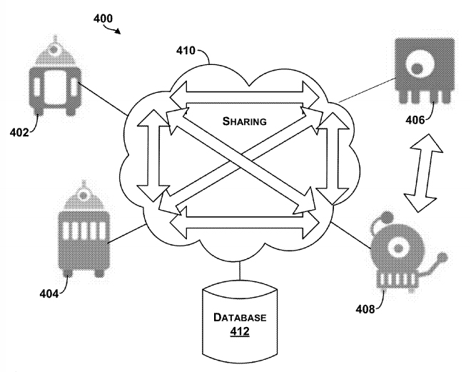
The Google patent shows an example system in which robotic devices interact with the cloud and share information with other cloud computing devices.
In a patent awarded April 14, Google describes “systems and methods for allocating tasks to a plurality of robotic devices,” reports Nextgov.com.
Google’s patent (Patent #9,008,839)outlines methods for connecting a series of robots over the cloud to complete tasks. A robotic device configured to perform a task could make use of a GPS receiver to determine its location. It might also use other sensors, such as a gyroscope or an accelerometer to measure movement. Other sensors could be encoders, infrared sensors, optical sensors, biosensors, Radio Frequency identification (RFID) systems, wireless sensors and compasses.
The patent suggests that the robots could be controlled by a smartphone — from anywhere in the world.
The patent could have value for Google’s self-driving car project, allowing the vehicles to communicate with each other.
In another patent (Patent #US008996429), awarded on March 31, Google describes how a robot’s personality can be defined using sensors and the cloud. According to the patent, “methods and systems for robot and user interaction are provided to generate a personality for the robot.” One aspect includes basing the robot’s personality on identifying the user’s location.
The personality and state may be shared with other robots so as to clone this robot within another device or devices. In this manner, a user may travel to another city, and download within a robot in that city (another “skin”) the personality and state matching the user’s “home location” robot. The robot personality thereby becomes transportable or transferable.
Again, GPS is mentioned as a possible sensor for use either in the user’s smartphone, the robot, or both.
So, in the future, when you leave home, you may be able to take an interactive non-human friend along. Talk about location-based services!
Editor’s Note: Learn more about how the TerraGo Edge replaces single-use GPS handheld devices and enables mobile workers and field crews to easily collect and share field data. Attend GPS World’s May webinar, Say Goodbye Proprietary GPS Devices, Hello TerraGo Edge.
TerraGo, a geospatial collaboration and enterprise mobility software company, is offering a new version of its OpenGeoPDF software, now available with TerraGo Publisher for ArcGIS, TerraGo Composer and TerraGo Toolbar. The latest release gives end users powerful new spatial database features, including the ability to search and update feature attributes, with an interactive OpenGeoPDF map accessible to any end user without requiring them to purchase any software.
“TerraGo’s OpenGeoPDF lets people turn static maps into interactive GIS-lite applications by letting ArcMap users share a free portable client application,” said Kevin Coles, manager of Enterprise GIS at Lumos Networks. “With OpenGeoPDF, end users can do more than view maps and imagery. They can interact with maps in ways previously only available with GIS software including the ability to control layers, measure distances, query, update and extract feature data in a universal format.”
OpenGeoPDF produces a measurable return on investment by enabling organizations to leverage their GIS investment to create free GIS-Lite solutions for non-GIS users. One of the many benefits of the OpenGeoPDF approach is that GeoPDF maps with embedded feature attributes can be accessed, searched, updated and extracted as an OGC (Open Geospatial Consortium) GeoPackage.
“The incredible value of geospatial data and an organization’s investment in GIS should result in more than a paper map or flat image in a PowerPoint,” said TerraGo Chief Technology Officer George Demmy. “OpenGeoPDF offers limitless, new possibilities for geospatial data interchange and creates much richer analytical applications for end users.”
To start a trial of TerraGo Publisher for ArcGIS, download here.
To start a trial of TerraGo Toolbar for Adobe Reader, download here.
Data Reviewer for Electric Utilities provides more than 40 out-of-the-box checks that users can run individually, group into batch jobs (as .rbj files), or run as a scheduled service.
Esri has released a Data Reviewer for Electric Utilities. It provides the preconfigured ArcGIS Data Reviewer for Desktop to be used to validate, maintain and improve the integrity of electric distribution data.
Data Reviewer for Electric Utilities provides a set of tools to simplify many aspects of automated and visual data quality control. The solution provides more than 40 out-of-the-box checks that users can run individually, group into batch jobs (as .rbj files), or run as a scheduled service.
“As utilities continue to collect more information about their electric network, it’s imperative that this information be validated to ensure accuracy and completeness of the overall content,” Esri solutions team lead Patrick Dolan said. “The release of Data Reviewer for Electric Utilities allows utilities to automate the way they validate and measure the overall health of their electric distribution network, providing them with greater insurance that the electric network is accurate and complete.”
To celebrate the fifth anniversary of Let’s Move!, First Lady Michelle Obama and The Partnership for a Healthier America have launched the Let’s Move! interactive map to encourage healthier lifestyles for children. Available to the public online, the map showcases the impact of these programs across the nation and makes it easier to get involved in local efforts.
Built on Esri’s ArcGIS Online platform, the map allows users to search for their location by city or ZIP code to see what schools, localities or organizations near them are participating in a Let’s Move! program. Users can also view a full-screen app to explore each program individually.
Fleetmatics has released the second edition of its FleetBeat Report, an in-depth analysis of tens of billions of data points extracted from thousands of commercial fleets managed using the company’s Software as a service (SaaS) platform over a span of four years. The report, “FleetBeat, Vol. 2: The Economy in Motion,” was co-authored by Stephen Fuller, Ph.D., professor and director of the Center for Regional Analysis at George Mason University.
Fleetmatics says the data included in the report reveals that performance of small businesses in the services industry directly reflects the health of the economy.
“It has long been said that retail sales trends are often impacted by the health of small business,” said Jim Travers, chairman and chief executive officer of Fleetmatics. “Fleetmatics is uniquely positioned to analyze small business services activity given we have one of the largest fleet management data clouds in the world. Also, our customers are typically in the earlier phases of consumer consumption, such as distribution of goods and home deliveries.”
As outlined in the report, the data extracted from Fleetmatics fleet management data cloud suggests that performance of small business services companies can be a highly credible indicator of national and regional economic health, even under changing conditions. The report also looks at small business services performance and retail sales in four Metropolitan Statistical Areas (MSAs), and concludes that geographic features can significantly define regional small business activity profiles.
“This is truly a groundbreaking new report, viewed from the perspective of the fleet management industry,” said Fuller. “Based on Fleetmatics’ FleetBeat second edition report, Fleetmatics data explains much of the variation and growth in retail sales. Furthermore, when comparing the Fleetmatics’ small business service fleet activity data with the retail sales data from Moody’s and the U.S. Bureau of Census, it’s clear the two data sets exhibit an extremely high correlation. I believe the ability to analyze real-time telematics data can now be considered an accurate data source on the small business flow of goods and service.”
With a dataset of over 10.7 billion telematics-generated data points from commercial vehicles managed with the Company’s SaaS platform in the United States, the report used regression analysis to compare the data with national monthly retail sales data.
There were eight telematics-derived, independent parameters considered in the analysis, both in aggregate and at the per vehicle level, including those related to mileage, number of vehicle stops, mileage per stop, number of active vehicle days per month and number of vehicles active in a month. The data was drawn from small business customers defined as entities having fleets from 5 to 100 vehicles, and only fleets from business types that were related to or supporting retail and service sectors were considered.
The report also examined regional differences that drive activities of small business services companies in four markets: New York, Chicago, San Francisco and Miami. The result was an in-depth breakdown of the most prominent indicators of small business economic activity and correlation to retails sales in each core market.
Fleetmatics’ first FleetBeat report highlighted the economic impact of telematics adoption and quantifiable benefits of business intelligence-driven fleet management. The report found that the total estimated economic impact of commercial fleet vehicles armed with telematics – assuming everyone had the same results as Fleetmatics’ optimized customers – would amount to $2.2 billion in fuel savings, a decrease in carbon dioxide emissions by 5 tons per year and $34.9 billion in total cost savings due to decrease in payroll hours.
The Coperinicus Masters Cup Photo: Anwendungszentrum GmbH
Copernicus Masters submissions of ideas, applications or business concepts involving innovative uses of Earth observation data are due by July 13. Along with cash prizes, the winners will gain access to an international network, corresponding data, start-up funding and other support valued at more than €300,000 ($322,444) total.
The amount of data produced by Copernicus, the European Earth observation program, and its Sentinel satellites opens the door to products and applications in a wide array of business sectors. The European Space Agency (ESA) and Anwendungszentrum GmbH Oberpfaffenhofen (AZO) have thus initiated the Copernicus Masters competition to aid visionary entrepreneurs in bringing their innovations to market.
“Start-ups and SMEs in particular stand to benefit from the virtually limitless scope of the data Copernicus provides,” said Prof Dr Volker Liebig, director of Earth observation programs and head of the European Space Research Institute (ESRIN), ESA. “The ideas submitted to previous editions of the Copernicus Masters have already demonstrated this to impressive effect, as has the constantly growing number of companies that are developing products and services based on Earth observation data in ESA’s business incubation program.”
These companies operate in a diverse range of fields, where they address subjects such as resource efficiency in agriculture, construction and renewable energy. The Copernicus Masters also is looking for new services and products in forward-thinking segments such as big data, cloud computing, crowdsourcing, data visualisation and mobile applications, to name a few.
In this year’s edition, prizes will be awarded in topic-specific challenges sponsored by partners, including: ESA, the German Aerospace Center (DLR), T-Systems International GmbH, Satellite Applications Catapult Ltd., Greece’s National Cadastre and Mapping Agency (NCMA), CloudEO AG and European Space Imaging GmbH. The new University Challenge specifically addresses students and research assistants around the world.
“We and our partners are offering the participants space for innovation in areas that are already shaping the future — the Internet of Things (IoT), Industry 4.0, smart cities and renewable energy, for example,” said Thorsten Rudolph, AZO managing director. “We want to support them in realising their creative solutions to these global challenges.”
Research and industry experts will select the winner of each challenge. The overall winner and 2015 Copernicus Master will receive, along with their challenge prize, €20,000 ($21,478) in cash and a satellite data package worth a further €60,000 ($64,434), which is being provided with the financial support of the European Commission.
“Taking part in the Copernicus Masters gave us the chance to make some key contacts and gather valuable feedback,” said John Smedegaard, a co-founder of Ceptu, which won the CloudEO Farming Challenge in 2014. “The whole process was a huge help in advancing our idea and developing it into a commercial product through our new start-up.”
All of the winners will be announced this fall and recognized at an awards ceremony.
For details on this year’s prizes, partners and terms of participation, view the event website.
On Wednesday, the GPS Directorate said further data analysis shows that a technical error affecting some Boeing GPS IIF satellites first appeared in 2011, two years earlier than originally stated, according to a Reuters report.
The error first appeared one year after the GPS IIF satellites became operational. The error affects the way the ground control system builds and uploads messages transmitted by the satellites, but does not affect the accuracy of GPS signals. It involves the ground-based software used to index messages.
Lockheed Martin runs the GPS ground control segment, which enables Air Force officials to operate all GPS satellites, including the IIF satellites built by Boeing.