Blog

  • International Symposium on GNSS Coming to Kyoto

    International Symposium on GNSS Coming to Kyoto

    Logo: International Symposium on GNSS

    The 2015 International Symposium on GNSS has been announced for Nov. 16–19 in Kyoto, Japan, and registration is now open, along with full information about the event.

    The GPS/GNSS International Symposium was first held in 2000 in Seoul and has been held annually ever since, rotating among Korea, China, Japan, Australia, Malaysia and Taiwan. The 2008 meeting in Tokyo attracted 428 attendees, including 179 foreign delegates, and 188 papers were presented. The 16th Symposium will be held in Kyoto, a beautiful historic city and the ancient capital of Japan.

    Important dates for paper submission:

    • June 30 : Abstract Submission for Scholarship application and Refereed Papers
    • July 31: Full paper Submission for Scholarship application and Refereed Papers
    • August 15: Abstract Submission for Regular Papers
    • September 15: Acceptance Notification
    • October 15: Full Paper Submission.

    Registration dates:

    • Early-bird registration: April 1 – August 18
    • Regular registration: August 19 – October 31

    Session tracks include:

    • Global Satellite Navigation Systems (GPS, GLONASS, Beidou, Galileo)
    • QZSS and Regional Systems
    • Augmentation Systems (SBAS, GBAS, etc.)
    • Next-Generation GNSS
    • Inertial Systems for Positioning & Orientation
    • Signal Processing in Navigation Systems and Systems Integration
    • Interference, Jamming and Spoofing
    • GNSS Receivers and Antenna Technologies
    • Autonomous Navigation (Car, Boat, UAV)
    • Agricultural and Construction Machines Control
    • Multi-sensor and Integrated Navigations
    • Aviation, Marine and Land Applications
    • Tsunami and Landslide Monitoring
    • Earthquake Prediction with GNSS Monitoring
    • Timing and Science Applications
    • Space Weather and Atmospheric Effects on GNSS
    • Geodesy, Surveying, Mapping and RTK Applications
    • Precise Positioning with QZSS Data Transmission
    • Space Applications and Remote Sensing
    • Algorithms and Methods
    • Novel Applications
    • Indoor Navigation / Indoor Mapping / Urban Navigation / Personal Navigation
    • Other Topics Related to PNT.
  • Galileo Update, Ionospheric Model Shared at ENC

    This year’s European Navigation Conference (April 7–10 in Bordeaux, France) got underway with “Good news from up there .…”

    Galileo’s seventh and eighth satellites launched successfully in late March, the European Space Agency (ESA) plans four more satellites to reach orbit in 2015, and space maneuvers for Galileo 5 and 6 have been completed, with a recovery plan currently under study. ESA also happily confirms that satellites 7 and 8 are in good position, under control, and behaving very well.

    Fiammetta Diani, deputy head of Market Development for the European GNSS Agency (GSA) followed her keynote opener with “ . . . some good news also from down here.”

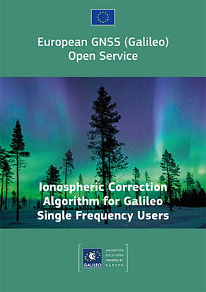
    Photo: European GNSSThe GSA has just published a new document on the NeQuick Ionospheric Model, used to compensate ionospheric errors on Galileo and other GNSS signals. The document, titled “European GNSS (Galileo) Open Service Ionospheric Correction Algorithm for Galileo Single Frequency Users,” and downloadable, contains detailed description and results from years of intense research.

    Ionospheric Model

    The NeQuick model improves accuracy levels globally when using single-frequency services, even during hyperactive periods of the 11-year solar cycle, according to the GSA.

    (Last year, authors from the European Space Research and Technology Centre (ESTEC) at the European Space Agency (ESA) published an article in GPS World magazine, “Innovation: the European Way,” as the Innovation column edited by Richard Langley. From Langley’s introduction to the article: “The ionosphere is a dispersive medium for radio signals, so by making measurements simultaneously on two frequencies transmitted by a satellite, most of the effect of the ionosphere can be removed. However, single-frequency devices such as most vehicle navigation and handheld receivers don’t have the luxury of dual-frequency correction. These devices must rely on a single-frequency correction model. The coefficients for such a model are included in the navigation messages transmitted by all GPS satellites. Known as the Ionospheric Correction Algorithm or Klobuchar Algorithm, it removes at least 50 percent of the ionosphere’s effect.

    “The Galileo satellites also include the parameters of an ionospheric algorithm, called NeQuick G, in their navigation messages. In this month’s column, the Galileo system design team describes the novel European way for modeling the ionosphere for single-frequency users and compares its performance to the current GPS approach.”

    The online version of the Innovation column contains an extensive Further Reading list, including resources on the GPS (Klobuchar) ionospheric model.)

    Receivers operating in single-frequency mode may use a single-frequency ionospheric correction algorithm,which is given in the report in the form of two equations, to estimate the ionospheric delay on each satellite link. The Effective Ionisation Level, Az, is determined from three ionospheric coefficients (broadcast within the navigation message) and the Modified Dip Latitude (MODIP) at the location of the user receiver. MODIP is expressed in degrees and a table grid of MODIP values versus geographical location is provided together with NeQuick G model. The receiver then calculates the integrated Slant Total Electron Content along the path using NeQuick G and converts it to slant delay using a stated equation for ionosphere group delay (delay on the pseudo-range or signal code phase), neglecting higher order terms.

    A further section of the report describes practical guidelines for the implementation of the single-frequency ionospheric model within Galileo user receivers, with sub-sections detailing:

    • Zero-valued coefficients and default Effective Ionisation Level;
    • Applicability and coherence of broadcast coefficients;
    • Effective Ionisation Level boundaries;
    • Integration of NeQuick G into higher level software;
    • Computation rate of ionospheric corrections.

    In a document annex titled “Performance Results,” the performance of the model is compared with that of the GPS Ionospheric Correction Algorithm (ICA) algorithm, also known as the Klobuchar model.

    “As an example of the behavior of the two models as a function of the time of day, the delay computed using Klobuchar and NeQuick G are plotted as a function of the satellite elevation and of UTC in Figure 5. For this example, in order to have a direct comparison between the two models, the delays computed using Klobuchar and NeQuick are compared with respect to the delay estimated using Global Ionospheric Map (GIM). The plots have been computed for a station in latitude [deg] 40.8234, longitude [deg] 14.2161, altitude [m] 122.6590 m, using GPS satellite PRN 11 and for day 16 of year 2010 characterized by quiet geomagnetic activity.”
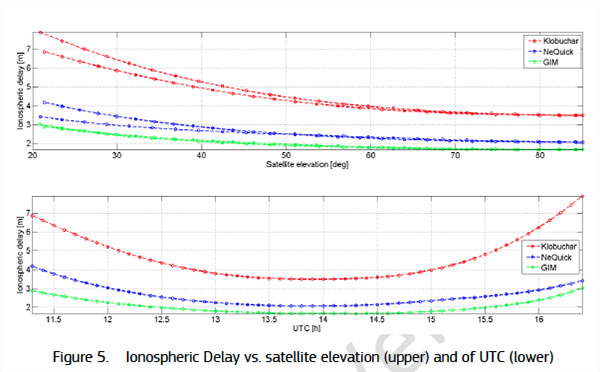
    GNSS-D&T-Figure-5

    Several further figures and tables within the document annex give more details on the performance results obtained.

    The NeQuick electron density model was developed by the Abdus Salam International Center of Theoretical Physics (ICTP) and the University of Graz. The adaptation of NeQuick for Galileo single-frequency ionospheric correction algorithm (NeQuick G) has been performed by the European Space Agency (ESA) involving the original authors and other European ionospheric scientists under various ESA contracts.

    GNSS Market

    In market forecasts, Diani related some high-level results from the GSA’s 2015 GNSS Market Report.  Among other insights, the GSA predicts that the installed base of GNSS devices will triple by 2023, with per capita rates of 2.5 in North America (currently 1.4), and 2.3 in Europe and Russia (now 1.1 and 0.8, respectively). Around the rest of the world, in eight years nearly every person, on average, will possess a GNSS device. Currently rates are 0.5 in South America, 0.2 in Africa, and 0.4 in the Middle East and non-Russian Asia.

    Galileo Services: Proposal for an Industry Policy

    Axelle Pomies of Galileo Services, an association of industry players active in GNSS applications, stressed the need for a comprehensive, assertive industry policy to support the development of EGNOS/Galileo downstream sector, leading to growth, job creation, and autonomy for Europe.

    As stated in her presentation, GNSS market trends do not currently favor Europe, as the continent aggregately currently holds a market share of less than 20%, whereas the usual European market share in other high-tech sectors is around 33%. European GNSS downstream industry suffers from a competitive disadvantage vis-à-vis industry from other regions, because dedicated national programs/strategy in the United States, Russia, China, and Japan support competitiveness of their respective industries and enhance GNSS market take up, including funding from R&D to manufacturing capabilities; regulation; and massive public procurement. Europe has none of these, or at least not to the same degree.

    Among the risks this entails for European Union autonomy are that Galileo may not be used as intended; there is little predicted interest for most user applications to track four constellations. Meanwhile GPS, GLONASS and BEIDOU are already in place.

    She cited a number of key GNSS application markets where European industry must position itself strongly and securely. In her view, the most promising markets in terms of growth potential and strategic placement include:

    • Road (intelligent transport systems, connected vehicles, and advanced driver asisstance systems, or ADAS)
    • agriculture
    • autonomous/unmanned vehicles
    • rail
    • timing
    • critical infrastructures
    • multimodal logistics
    • defence
    • Internet of Things.

    In that regard, Pomies posited the necessity of a comprehensive and assertive industry policy to support the development of EGNOS/Galileo downstream sector, with the goals of  fostering the use of European GNSS infrastructures; encouraging European Industry to develop EGNSS equip/apps; fostering the manufacturing of E-GNSS based solutions in Europe; and supporting the European industry competitiveness in the GNSS global market and fostering the emergence of European champions.

    Support from European and national institutions is necessary for the full success of the EGNOS programmes, she said, and she previewed the mid-May publication of a draft position paper from Galileo Services in this regard, for wide consultation within the European downstream sector.

    Follow www.galileo-services.org for its first appearance.

    Key Issues in Intelligent Transport and Location-Based Services

    Concluding the ENC plenary, Florence Ghiron of Topos Aquitaine, a regional council of satnav and intelligent transport companies in southwest France, focused on opportunities and risks for small-to-medium enterprises. One of her key points regarding the intelligent transport systems market: the long development paths of public and regulatory policy do not help SMEs grow.

    Today, several GNSS-based road schemes are already operational, but they tend to be limited to specific applications, to regional areas and/or to specific classes of vehicles, for example, trucks above a certain weight !

    Moreover, each country tends to work with their national champion. This has led to fragmentation of the targeted markets all over Europe. Thus, the need for interoperability between schemes is an increasingly important factor.

    Among her major recommendation for supporting application and business development:

    Support GNSS stakeholders at promoting their innovative GNSS applications towards the largest possible community. This encompasses:

    • Visibility of GNSS mature solutions/applications

    • Cost-benefit analyses for already developed GNSS-applications

    • Identification of the best ways/means to help SMEs  promote their offers towards public purchasers

    • Development of a Directory of European regional and national contact points

    She further proposed additional funding mechanisms for SMEs to bridge the gap between the R&D step and the industrialization/market development phase.

    Finally, help medium/small regions and cities to purchase or procure the innovative GNSS-ITS applications they need to answer their public transportation/mobility needs.

    Further information on the Topos project SUNRISE (Strengthening User Networks for Requirement Investigation and Supporting Entrepreneurship), a European project managed by the GSA, may be found at www.topos-aquitaine.org.

    Back to Bordeaux in October

    Both Diani and Ghiron closed their presentations with invitations to return to Bordeaux in October for the Intelligent Transport Systems World Congress, themed “Towards Intelligent Mobility: Better Use of Space.” GNSS looks to take a more central role than ever in this far-reaching economic segment.
  • GIS Cloud Previewing Collaborative App Maplim

    GISCafe-Maplin

    GIS Cloud is previewing Maplim, an application that allows for fast, intuitive real-time collaboration on a map using any device. GIS Cloud is offering sign-ups for free, early access to Maplim.

    According to GIS Cloud, “The idea is to put a map in the context of an organization board where you created projects and cards while engaging with your colleagues in discussions, making drawings (redlining and annotations), attaching documents, or just leaving comments.

    Features:

    • Organization. Create real-time collaboration streams as cards, to which you can add any content around a map and share it with your colleagues. Maplim adapts to your project, team, and workflow.
    • Redline and Comment. Seamlessly make drawings on a map, add notes, marks, and comments, and provide your team with everything they need to get things done in real time.
    • Sharing. Attach and access important media such as photos, videos, PDFs, and Excel and Word documents relevant to a card.
    • Sync. Maplim stays perfectly in sync across all your devices, wherever you are. Post comments for instant feedback, follow your team’s activity in real time, and share results with anyone, anywhere, and on any device.

    GIS Cloud is offering a free webinar on Maplim on April 28.

  • Nokia Selling HERE, Indoor Location Intensifies

    Janice Partyka
    Janice Partyka

    It has been an interesting month for developments in location. Nokia is looking for a buyer for HERE, the mapping and navigation business that once set the industry gold standard. While carriers are planning how they will comply with new FCC mandates for locating indoor E911 calls, the commercial indoor location market has moved beyond “emerging” and is well underway. It is a confusing ecosystem for buyers of indoor location solutions. And there is yet another mega-entry into the connected vehicle market, Alibaba and China’s SAIC Motor.

    With the likely merger of Nokia and Alcatel-Lucent, Nokia has started looking for a buyer for its digital map and LBS division. The mapping industry has changed dramatically since Nokia purchased the mapping leader Navteq in 2007. Google has become a mapping juggernaut, and less accurate free maps have become serviceable for many types of uses. In fall 2014, Nokia took a EUR1.2-billion impairment charge on HERE’s book value and now estimates the fair value for HERE at EUR2 billion. Possible buyers include Google, Microsoft, Apple and Uber, all companies with deep pockets and hardy appetites.

    Indoor Location Market Is Messy. The indoor location market is pulling away from the station, as technology is ready and there are applications and use cases primed to get started. Unfortunately, the market is chaotic, teaming with companies offering solutions with various levels of accuracy, infrastructure requirements and cost. An ideal indoor location technology would provide at least 3-meter accuracy, be cost effective and fully universal, working anywhere on all devices. It doesn’t exist, but the competing technologies, all with trade-offs, will find applications that fit. For instance, the precision required in locating an apartment in the case of an E911 emergency call differs greatly from the pinpoint accuracy need by an app that directs a shopper to Lucky Charms cereal on an aisle crowded with boxes.

    One Size Doesn’t Fit All. There is more to an indoor location technology than accuracy. “Accuracy is important, but so is universality, the ability to work everywhere and in all phones. So is cost, in terms of the investment required from a site deploying the technology,” asserts Bruce Krulwich of Grizzly Analytics. “Universal technologies can win in the market even if they’re less accurate, and technologies with cheaper infrastructure can win even if they’re less accurate than those with expensive infrastructure. High-end systems can deliver sub-meter accuracy to those willing to pay for it.” Grizzly Analytics just completed a comprehensive report on the indoor location market.

    Test First. Each of the numerous companies vying for the indoor location market makes claims regarding accuracy, availability/coverage, latency and battery usage. Judicious companies that invest in indoor location systems would be wise to test the claims of vendors. “Making a fair comparison among different indoor location offerings is complex, and nuances in how the testing is performed need to be controlled to ensure an apple-to-apple comparison,” asserted Khaled Dessouky of ComVerity. “It is important to use an unbiased methodology that relates to your use cases.” Dessouky managed the neutral test bed for the FCC’s Communications Security, Reliability and Interoperability Council (CSRIC) for indoor E911 calls.

    Quuppa. An interesting highly accurate offering comes from Quuppa, a Finnish company with a bunch of high caliber researchers spun off from Nokia. Like some others, they are using Bluetooth Low Energy (BLE) beacons, but add angle of arrival (AOA) algorithms that pump up the precision, which they self-report to be 30 centimeters to 1 meter. With this performance, Quuppa has been used in sports to track hockey pucks and athletes’ movements during game play for coaching, player load monitoring and infotainment that can be broadcast during the game. The use of this type of high-precision location in health care settings is compelling. Patient flow management, security and critical asset tracking can be improved with precise positioning technology. Quuppa is a system that likely wouldn’t be used in apps that locate a coffee shop at a mall, but for uses that demand high performance and can spare some expense, it is compelling.

    And Yet Another Mega Entry. The number of companies vying for a piece of the connected-car market keeps expanding and getting more international. E-commerce giant Alibaba and SAIC Motor, China’s popular car maker, together set up a $160 million fund to develop “car on the Internet.” Alibaba will be leveraging its communications, entertainment, map and cloud-computing services. The company joins a group that includes Google, Apple, Baidu and Uber in challenging auto makers.

  • Esri Book Explores Spatial Thinking, Research Using GIS

    GIS Research Methods provides a solid introduction to research methods using GIS.
    GIS Research Methods provides a solid introduction to research methods using GIS.

    Scientific data that’s spatially analyzed produces highly useful information for academics, scientists and other researchers, helping them answer questions and make well-informed decisions, according to a new book published by Esri.

    The book GIS Research Methods: Incorporating Spatial Perspectives shows how spatial analysis using geographic information system (GIS) technology enhances research in the social and physical sciences.

    Authors Sheila Lakshmi Steinberg and Steven J. Steinberg explain how to incorporate spatial thinking and GIS into research design and analysis. The book introduces readers to the value of thinking spatially, GIS basics, research design and ethics, data sampling and collection, volunteered geographic information, spatial analysis with Esri ArcGIS technology, and more. The authors are scientific researchers who have used GIS in their academic work.

    “A unique aspect of this book is that we focus specifically on how to integrate GIS into both qualitative and quantitative research,” the Steinberg’s wrote in the book’s foreword. “Our objective in writing this book is to provide a foundation for GIS research methods and, more specifically, to integrate spatial thinking and spatial analysis into a research tool with clear methodological techniques.”

    The book, which was written for social and physical science professionals and academics, provides an introduction to research methods using GIS. For example, readers will learn how to develop useful, spatial information-based interviews and surveys for collecting data in the field; select the right tools for spatial analysis; visualize spatial information; and communicate the results of analyses, Esri said.

    The book also outlines what to consider — for example, geographic boundaries, the data, and a diverse group of stakeholders—when creating strong place-based policies. “Policy makers who consider space and place will be more likely to generate policy that is effective in the long run because it has a better opportunity to consider the concerns, needs, and perspectives that tie to data, people, and place,” said the Steinberg’s.

    Sheila Lakshmi Steinberg is a professor of social sciences at Brandman University, based in Irvine, Calif. She earned her bachelor’s degree from the University of California, Santa Barbara; her master of science degree from the University of California, Berkeley; and her doctorate from Pennsylvania State University. Her research interests include environmental sociology, culture and GIS.

    Steven J. Steinberg is a principal scientist at the Southern California Coastal Water Research Project, a public environmental research agency based in Costa Mesa. He received his Bachelor of Science degree from Kent State University, his Master of Science degree from the University of Michigan and his doctorate from the University of Minnesota.

    GIS Research Methods: Incorporating Spatial Perspectives is available in print (ISBN: 9781589483781, 440 pages, US$79.99) or as an e-book (ISBN: 9781589484047, 440 pages, US$79.99). The book is also available at online retailers worldwide, at esri.com/esripress, or by calling 1-800-447-9778. Outside the United States, visit esri.com/esripressorders for complete ordering options, or visit esri.com/distributors to contact your local Esri distributor.

  • NASA’s James L. Green to Headline ION GNSS+ 2015

    NASA’s James L. Green to Headline ION GNSS+ 2015

    James L. Green, director of Planetary Science for NASA.
    James L. Green, director of Planetary Science for NASA.

    James L. Green, director of Planetary Science for NASA, will take the audience on a journey navigating through the solar system at The Institute of Navigation’s ION GNSS+ 2015 Conference.

    Green’s keynote address will show new worlds and new discoveries through the eyes of NASA’s planetary spacecraft. The conference takes place Sept. 14-18 at the Tampa Convention Center in Tampa, Florida.

    At NASA, Green is responsible for solar system exploration including astrobiology research. Under his leadership, a number of recent planetary science mission events have been successfully completed, including the New Horizons space probe which is scheduled to reach Pluto on July 14, Messenger orbit insertion at Mercury, the launch of Juno to Jupiter, the launch of Grail A and B to the Moon and subsequent orbit insertion, Dawn’s encounter with Vesta, and the landing of the Mars Science Laboratory and Curiosity rover on Mars. He has published more than 100 scientific papers on the magnetosphere of Earth and Jupiter. He has also contributed more than 50 technical articles on various aspects of data systems and networks.

    Green received his Ph.D. in physics from the University of Iowa in 1979 and has worked at NASA’s Marshall Space Flight Center and Goddard Space Flight Center before becoming the director of the Planetary Science Division at NASA Headquarters in 2006. In 1988 he received the Arthur S. Flemming award given for outstanding individual performance in the federal government and was awarded Japan’s Kotani Prize in 1996 in recognition of his international science data management activities

    Sponsored by the ION’s Satellite Division, ION GNSS+ is the world’s largest international technical meeting and showcase of GNSS technology, products and services and brings together international leaders in GNSS and related positioning, navigation and timing fields to present advances, introduce new technologies, update current policy, demonstrate products and exchange ideas.

  • Fugro Adds Bathymetry Capability before Pacific Campaign

    Fugro has commissioned an additional airborne laser bathymetry system to underpin its position in the development and application of bathymetric LiDAR technology. The combined Fugro LADS Mk 3 and Riegl VQ-820-G systems provide seamless measurements and mapping of nearshore and shallow water environments. The increased capability will enable Fugro to deliver simultaneous topographic and bathymetric surveys in multiple geographical areas.

    With high power and frequency, the combined systems achieve superior coverage that minimizes gaps and outperforms lower energy alternatives and single-sensor systems in all conditions, particularly in difficult environments, Fugro said. They are highly adaptable and small enough to be installed in a variety of light aircraft.

    With continued operations across the Middle East during 2015, Fugro will also begin a South West Pacific ALB survey campaign following the award of projects in multiple locations to support nautical charting, coastal engineering, scientific assessments, coastal management, benthic habitat mapping and climate change initiatives.

    Since 2012, Fugro has operated simultaneous topographic and bathymetric LiDAR systems in France, Japan, New Zealand and the Middle East. Successful results from Japanese coastal areas include returns from the Fugro LADS Mk3 sensor to 50 meters while recent surveys in Saudi Arabia had even more impressive results, with 65-meter depth returns. The deep water returns combined with high-density shallow water and near coastal returns result in a seamless dataset from ridge to deep reef.

  • Antenova M2M Showcases Brevis GNSS Tracking Antenna

    Antenova M2M Showcases Brevis GNSS Tracking Antenna

    Antenova Brevis
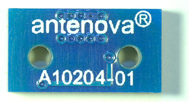
    Antenova Brevis antenna is tiny at 11mm x 6mm.

    The Brevis GNSS antenna is the latest addition to Antenova’s gigaNOVA family of miniature antennas. The small antenna is designed to be used in portable handheld devices that have GNSS receivers — for example, in devices and applications that have a tracking capability or location accessories such as in transport, navigation, wearables and eHealth.

    The multi-GNSS antenna is designed for embedded applications, with a high efficiency-to-size ratio. It is intended for use in applications where there is no ground beneath the antenna. It has near omni-directional characteristics which will provide good performance for any device.

    The Brevis operates with the following GNSS bands: GPS, GLONASS, Galileo and BeiDou. Brevis GNSS is a low-profile, small-footprint antenna designed for surface-mount device (SMD) mounting, so it can simply be placed on a printed circuit board (PCB) to add wireless connections to any device.

    Full technical specifications for the Brevis GNSS antenna and contact details for regional distributors are available on Antenova’s website.

  • Drones Take Off for Location Companies

    Drones Take Off for Location Companies

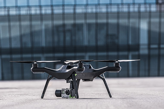
    3D Robotics Solo Drone with GPS embedded.
    3D Robotics Solo Drone with GPS embedded.

    The National Association of Broadcasters meeting in Las Vegas draws 100,000 attendees annually, making it one of the largest trade shows in the country. However, besides timing and some very niche markets, it has not been a big show for location companies. That is, until now, when NAB welcomed drone manufacturers, all of which embed GPS in their flying aircraft.

    Kevin Dennehy
    Kevin Dennehy

    LAS VEGAS — Commercial drones, a growing market for location companies, was one of the most popular topics at the National Association of Broadcasters Show, held here April 13-16.

    The market for drones has grown nearly five times in the last few years, said Eric Cheng of DJI, which uses GPS in its virtual positioning system that monitors and controls the aircraft. The company markets what they call “flying cameras” that look suspiciously like drones. “The market was initially hobbyists, but now some major broadcast players are buying the cameras,” Cheng said at the Showstoppers trade event the day before NAB.

    Most of the drones offer GPS-based automatic flight stabilization technology. Some even offer a long-range wireless signal and low-latency video transmission.

    Many of the drones are programmed so they don’t go higher than mandated FAA rules or go into restricted, no-fly aviation zones — and all use GPS to do this. Some of the drones even return to the user automatically when their batteries run low.

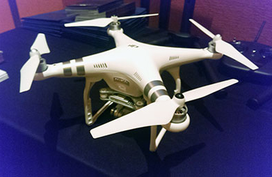
    DJI drone with embedded GPS.
    DJI drone with embedded GPS.

    DJI offers three cameras for the drones. The high-end Phantom 3 Advanced offers 1080P HD video at 60 frames per second. The 1080P version costs $995.

    In terms of privacy and government regulation, U.S. regulators are way behind Europe, Cheng said. “Other countries are way ahead of the [United States] in terms of working with drone companies,” he said. “In terms of privacy, the step ladder was the first tool for the invasion of privacy. They haven’t outlawed step ladders.”

    The slow U.S. regulatory process has forced some manufacturers to go to other countries to test their drones, said Roger Sollenberger, 3D Robotics’ editorial director. “[U.S. regulations] have moved slowly here — despite the government knowing about worldwide drone rollouts. In Japan, they have been using drones to crop dust for 20 years,” he said.

    Furuno's Don Hanham with GNSS modules at NAB.
    Furuno’s Don Hanham with GNSS modules at NAB.

    To signal increased interest in the commercial drone market, 3D Robotics raised $70 million dollars in funding, led by investor Qualcomm, Sollenberger said. The company, which partnered with action camera giant Go Pro, says its Solo drones can be used not only by broadcast companies, but for railroad track and building inspections.

    As GPS World reported, Furuno Electric Co.’s latest multi-GNSS receiver module, GN-87, has been adopted for the new quadcopter Bebop Drone. The broadcast market has been a good one for company’s timing products, drone integration and even weather prediction, said Don Hanham, a Furuno sales and marketing consultant.

    Furuno is marketing its Doppler Weather Radar System for broadcast. The system allows weather predictors to follow the development of short, localized rainstorms and extreme weather conditions.

    Booz Allen Hamilton Releases Report on 2015 Automaker Priorities

    The era of automotive connectivity, and subsequent heavy competition, is the focus of Booz Allen Hamilton’s new report, “Getting the Customer Experience Right: Auto Industry Priorities in 2015.”

    The company says that automakers should consider six key priorities this year: deliver innovation in months, not model years; differentiate with new partnerships to catch customers’ attention; secure connectivity to reinforce a relationship of trust with customers; address the “so what” of connected cars; personalize the customer experience via the tremendous potential buried in data; and find and build the market for alternative fuel vehicles.

    In terms of big connected vehicle technologies this year, Jon Allen, a principal with Booz, cites 4G pipe in GM and Audi vehicles and over-the-air updates by Ford and BMW, among others. “New parental controls in the Chevy Malibu report average speed and near misses while also preventing drivers from turning on the stereo until seatbelts are fastened. It’s easy to imagine this across vehicles, with parents receiving text messages in real time,” he said.

    Allen said, in terms of vehicle connectivity, automakers must answer the “so what” to set themselves apart from the competition. “We have yet to see the seminal, game-changing connectivity plays. Most companies are still in the ‘features’ mindset, offering new à la carte enhancements,” he said. “They’re not yet articulating a top-down strategy for re-envisioning the customer experience with connectivity.”

    One of the company’s six priorities concerns connected security, which has been a big industry issue since the recent release of the Markey Report, which focused on how vehicles can be hacked. “We have clients who get it.  They’ve identified a senior leader to champion vehicle cyber security and backed them up with a cross-functional team that works closely with counterparts across the organization — in product engineering, supply chain, safety, privacy and IT,” Allen said.  “Other OEMs are still formulating their approach. That said, there are pockets of cyber security across every organization, focused on implementing security controls on individual parts. The challenge is taking the next step —moving from this segmented, ‘assembly line approach’ to a more unified program that focuses on securing the complete vehicle ecosystem.”

    Allen said the company has to speak honestly to customers and regulators about how to manage vehicle cyber security risk. “Industry leaders must prioritize their security approach to ensure that higher risk scenarios are addressed first, rather than try to take on all elements of the challenge at once,” he said.

    Another priority addresses the long lead times, by automakers, to develop and roll out new features, which is a challenge, Allen said. “Consumer electronics, telecommunications and software companies are redefining the traditional industry boundaries that once distinguished them from OEMs. These companies focus on connectivity and services from the start of their product design process,” he said. “The key for automakers going forward is to continue learning from these new competitors, particularly around rethinking the vehicle lifecycle, connected product design, and managing vehicle software updates after purchase. In the near future, automakers will need different approaches to building and enhancing infotainment systems that can keep pace with customer demands.”

    The marriage of autonomy and connectivity is a game-changer, Allen said. “It isn’t just about plugging vehicles in to the Internet of Things. Autonomy transforms transportation,” he said. “When a car drives you, it becomes a retail outlet, a personal assistant, even a trusted chaperone — that all depends on getting both autonomy and connectivity right.”

    The rise of autonomous vehicles gets to the fundamental need for industry leaders to be willing to reimagine their product, Allen said. “Autonomous capabilities are not just about engineering a safer, more efficient, and more appealing mode of transportation. That’s important, but it’s really about a distinctly different product, one that creates a sustained, services-based relationship with the customer,” he said. “It will focus on the driving experience not just behind the wheel, but sitting comfortably inside of a self-driving vehicle. The connected, autonomous vehicle will change automotive for the better — and forever.”

    Allen said his company is seeing OEMs look beyond their individual vehicles to see the emerging connected society that includes ride sharing, multi-modal transportation and connected cities. “The way we go from point A to point B will look and feel drastically different 25 years from now; many OEMs are beginning to accept the change and embrace the challenge,” he said.

  • GPS IIF-9 Satellite Declared Operational

    GPS IIF-9, launched March 25, has been declared healthy and operational by the U.S. Air Force. The Air Force issued the following Notice to NAVSTAR Users (NANU).

    The next GPS satellite, GPS IIF-10, is scheduled for launch on June 16, with GPS IIF-11 following three months later, on September 16.


    NOTICE ADVISORY TO NAVSTAR USERS (NANU) 2015028

    SUBJ: SVN71 (PRN26) USABLE JDAY 110/2222

    1.     NANU TYPE: USABINIT

           NANU NUMBER: 2015028

           NANU DTG: 202222Z APR 2015

           REFERENCE NANU: N/A

           REF NANU DTG: N/A

           SVN: 71

           PRN: 26

           START JDAY: 110

           START TIME ZULU: 2222

           START CALENDAR DATE: 20 APR 2015

           STOP JDAY: N/A

           STOP TIME ZULU: N/A

           STOP CALENDAR DATE: N/A

    2.  CONDITION: GPS SATELLITE SVN71 (PRN26) WAS USABLE AS OF JDAY 110

        (20 APR 2015) BEGINNING 2222 ZULU.

    3.  POC: CIVILIAN – NAVCEN AT 703-313-5900, HTTP://WWW.NAVCEN.USCG.GOV

        MILITARY – GPS OPERATIONS CENTER at HTTPS://GPS.AFSPC.AF.MIL/GPSOC, DSN 560-2541,

        COMM 719-567-2541, [email protected], HTTPS://GPS.AFSPC.AF.MIL

        MILITARY ALTERNATE – JOINT SPACE OPERATIONS CENTER, DSN 276-3514,

        COMM 805-606-3514, [email protected]

  • ENSCO to Demo UAS Training Solution at Unmanned Systems 2015

    ENSCO Inc.VENOM, Unmanned Aerial System Training Suite, ENSCO Avionics IData will display its unmanned aircraft systems (UAS) solutions in booth 1551 at AUVSI’s Unmanned Systems 2015 show, held May 5-7 in Atlanta.

    Used primarily in military operations, ENSCO sees the value of UAS to law enforcement, agriculture, disaster evaluation and other civilian operations. The company is positioned to design, build, certify and support UAS in the National Airspace System based on its experience with the armed forces, the Federal Aviation Administration (FAA), and national security groups merged with its capabilities in avionics software and flight systems, PNT technology and weather forecasting.

    ENSCO will demonstrate its Virtual ENvironment Operations Module (VENOM), a solution for training UAS pilots and payload operators. Fully configurable to match any UAS platform, sensor payload and mission, ENSCO says VENOM provides modeling- and simulation-based training capability based on open architecture and commercial technology.

  • Topcon Offers Total Station with Enhanced Reflectorless Range

    GPT-3500_Field_Topcon-W Topcon Positioning Group has added to its line of reflectorless total stations for the construction and mining market. The GPT-3500LNW total station has a measuring distance of 2,000 meters (6,560 ft.). It is designed to measure further than any non-prism instrument in its class. “Incorporating the Topcon advanced time-of-flight pulse technology, the EDM is fast and powerful,” said Ray Kerwin, director of global surveying products. “The Topcon algorithm filters signal noise to provide accurate measurements even on dark and wet surfaces, where other reflectorless technology might fail.”

    The Topcon GPS-3500 total station.
    The Topcon GPS-3500 total station.

    Along with its onboard data collector, the GPT-3500 can connect to an external field controller via built-in Bluetooth technology, enabling field to office connectivity with the MAGNET suite of software solutions. The system can also be paired with a prism to allow for a measurement range of up to 3000 meters (9,842 ft.). Additional features include a rugged IP66 rated design, on-board TopField application software and battery life of up to five working hours.