Blog

  • Solar Storm Hits Earth’s Magnetic Field

    Solar Storm Hits Earth’s Magnetic Field

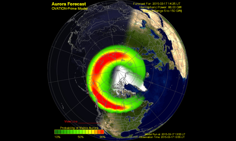
    A G4 (Severe) geomagnetic storm was observed today at 07/1358 UTC (09:58 am EDT). This is the response to a pair of CMEs observed leaving the Sun on 15 March. Shown here is a model depiction of where the aurora is likely visible. Storm conditions are forecast to persist for the next several hours before beginning to wane down towards the end of the UT day. (Courtesy of NOAA)
    A G4 (Severe) geomagnetic storm was observed today at 07/1358 UTC (09:58 a.m. EDT). This is the response to a pair of CMEs observed leaving the Sun on March 15. Shown here is a model depiction of where the aurora is likely visible. Storm conditions are forecast to persist for the next several hours before beginning to wane down towards the end of the UT day. (Courtesy of NOAA)

    A G4 (severe) geomagnetic storm is now taking place, the most powerful solar storm of the current solar cycle, reports Discovery.com.

    Initially triggered by the impact of a coronal mass ejection (CME) hitting our planet’s magnetosphere, a relatively mild geomagnetic storm erupted at around 04:30 UT (12:30 a.m. EDT), but it has since become a severe G4-class geomagnetic storm. Bright auroras were sighted over several northern-tier U.S. states including Minnesota, Wisconsin, Montana, the Dakotas and Washington. The storm could continue for many hours as Earth passes through the turbulent wake of the CME.

    Storm conditions are forecast to persist for the next several hours before beginning to wane down towards the end of the UT day.

    Not all types of solar activity (sun spots, solar flares, solar burst, and solar radiation) affect GPS receiver operations. Geomagnetic storms, however, can cause problems for GPS receivers if the storms are powerful enough.

    The solar cycle is about 11 years long, during which the sun waxes and wanes in magnetic activity.

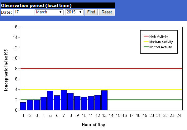
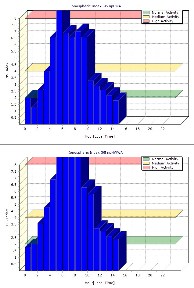
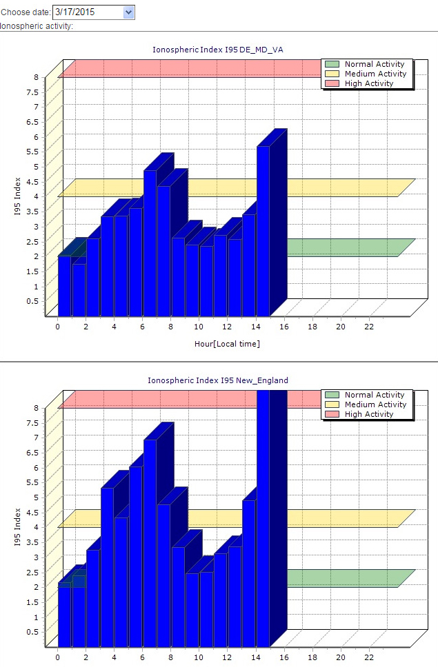
    Below are ionospheric charts from Missouri, Washington State and New England.

    Missouri ionosphere chart during the March 17 geomagnetic storm.
    Missouri ionosphere chart during the March 17 geomagnetic storm.
    Washington ionosphere chart
    Washington ionosphere chart during the March 17 geomagnetic storm.
    New England ionosphere chart during the March 17 geomagnetic storm.
    New England ionosphere chart during the March 17 geomagnetic storm.
  • Moscow Navigation Forum to Focus on GLONASS Market

    announcement
    Credit: Navitech

    The International Navigation Forum is a central event of year in the field of the commercial use of satellite navigation technologies — especially of the Russian navigation system GLONASS. The forum will be held April 22-23 at the Expocentre Fairgrounds in Moscow, in conjunction with the 7th International Exhibition on Navigation Systems, Technologies and Services (Navitech), which takes place April 22-24.

    The forum is designed to inform Russian and foreign audiences about state policies in the development and application of GLONASS technology in Russia and worldwide. It also aims to analyze the latest trends of the navigation industry, as well as to discuss the product and service market for various consumers and conditions for its export to foreign markets.

    The Navitech 2015 exhibition is aimed at world leaders in satellite navigation, as well as information technologies, geodesy and cartography. Navitech 2015 unites leading Russian and foreign developers and manufacturers of navigation equipment, services and software, including mapping apps. It reflects current world trends and serves as a main exhibition event for industry specialists. The Navitech Exhibition is the only specialized satellite navigation exhibition in Russia.

    The agenda of the 9th International Navigation Forum is designed for the end-user of navigation products and services, and highlights all aspects of their practical use for building a successful business and enhancing its efficiency.

    Forum attendees will receive detailed information about legal aspects of using satellite navigation, be introduced to navigation and communication equipment of leading Russian and foreign manufacturers, and learn about different industry applications and leading companies’ experiences in the practical use of navigation technologies, including business cases of using satellite navigation by Russian business representatives.

    Sessions and roundtables will present the most current information about developed products and important issues in the fields of navigation, mapping, and legal regulation. The participants will be able to give their suggestions on creating favorable conditions for the effective introduction of innovative technologies and exchange experiences.

    Forum topics:

    • Status and development prospects of GLONASS and foreign navigation satellite systems
    • Major development trends of the Russian market of navigation services and equipment
    • Practical experience of using satellite navigation technologies in different sectors of the Russian economy
    • Navigation technologies for intellectual transport systems
    • Information and navigation services, systems and equipment for mass market
    • Navigation technologies for passenger transport
    • Navigation and communication equipment of leading Russian and foreign manufacturers
    • Geoinformation systems for various purposes

    Exhibition topics:

    • In-vehicle navigation and information systems
    • Navigation technologies for land development, survey, design and construction
    • Automotive and personal navigation, equipment, LBS
    • Professional navigation equipment, modules and components

    To learn more, visit the websites: www.glonass-forum.com and www.navitech-expo.ru/en/. To participate as a delegate, speaker, sponsor or a partner, contact ProConferences by phone + 7 (495) 641 57 17 or email [email protected]


  • Counting Down to Galileo

    Galileo 7 and 8 launch on March 27. The Galileo satellite navigation system remains on track after successful in-orbit validation and the salvage for navigational testing of two satellites launched into an incorrect orbit. The mini-constellation of satellites in orbit plus their associated ground segment has allowed in-depth testing of the overall Galileo system, and the performance was good. Now with the launch of the latest pair of satellites, ESA and the European Commission are progressing with the deployment phase of the program.

  • Nat Geo to Offer Trail Maps on Avenza PDF Maps App

    Joshua-National-Park_800

    On the 100th anniversary of National Geographic’s Cartographic Division, National Geographic Maps will make available hundreds of maps from its Trails Illustrated line through Avenza Systems Inc.’s PDF Maps app.

    The addition of these outdoor recreation maps in North America augments the PDF Maps app digital map database by incorporating trail maps. It also increases National Geographic Maps’ reach within the mobile consumer market, giving more consumers access to the Trails Illustrated line. Trail maps from many of America’s national parks have already been uploaded to the app, including Yosemite, Yellowstone, Grand Teton, Zion and Great Smoky Mountains.

    With many Ranger Districts throughout the country discontinuing visitor services, Avenza’s PDF Maps app provides an alternative for outdoor enthusiasts planning a trip in remote areas where Internet service is not always available to stream detailed map content. Using National Geographic’s line of detailed recreation maps, PDF Maps app users can purchase, download and save maps on GPS-enabled devices such as Android- and iOS-based phones and tablets. Park visitors can use the app to find and mark location directly on the downloaded National Geographic map. Features include location tagging, dropping waypoints/pinpoints on points of interest, attaching images and notes, and tracking routes, distance and elevation — all while offline.

    John-Muir-Trail“National Geographic has a century-long history of creating accurate, detailed maps used by travelers, explorers and map lovers across the globe. Today’s technologies allow us to continue that history in the digital realm, expanding the ways consumers can acquire and use our maps,” said Daniel Ortiz, vice president and general manager, National Geographic Maps. “As we celebrate 100 years of National Geographic mapmaking, we are excited to bring the popular Trails Illustrated map line to Avenza’s PDF Map app users.”

    Avenza’s PDF Maps app provides constant access to geographic information and points of interest, with additional interactive tools such as measuring, place marking and location tagging. PDF Maps operates without the risk of lost reception due to cell tower proximity. It does not rely on an Internet connection.

    “Avenza’s PDF Maps app provides the ability for anyone to share map-related information by documenting locations with customized notes, photos and descriptions,” said Ted Florence, president of Avenza Systems Inc. “This expands the utility of a map beyond location guidance, as it is also a tool to share experiences and locales. We continue to strengthen our community of map publishers while further advancing the mapping tools consumers demand, and we look forward to seeing how the industry evolves in an ever-mobile community.”

    Avenza’s PDF Maps app is available now on the iTunes App Store and the Google Play Store, free of charge for personal use, with a Windows version coming soon. National Geographic maps can be accessed via the PDF Maps in-app store. Pricing of each map is set by the publisher, and free maps remain free to users through the PDF Maps app in-app store.
  • New app for farmers enables smartphone nav in the field

    New app for farmers enables smartphone nav in the field

    Agribus-NAVI
    Photo: Agribus-NAVI

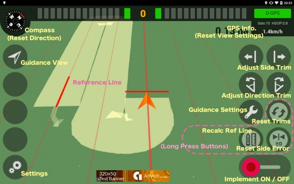
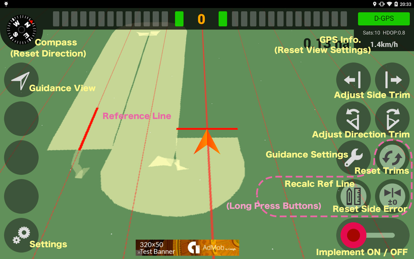
    A new app available on the Google Play store enables farmers to use their smartphone in the field.

    AgriBus-NAVI is a GPS guidance system to mount on agricultural machinery such as tractors, combines and self-propelled sprayers to help with straight-line tasks in the field. Checking the display while driving will enable the creation of straight and evenly spaced lines in large fields.

    The app, which is compatible with Android 4.0 and above smartphones and tablets, doesn’t offer the automatic steering functionality that dedicated precision agriculture GPS devices usually do.

    The app, by Agri Info Design, is based on the software “Agricultural Vehicle Navigation Software for Field Operation” and a patent “JP-4572417-B2” developed by National Agricultural Research Organization (NARO).

  • New Report Considers GNSS Market Outlook 2015-2020

    Research and Markets has added the report “Global Navigation Satellite Systems Market Outlook 2020” to its offerings. The global core GNSS market is forecast to grow at a CAGR of 9 percent during 2015-2020.

    In the report, the analysts have identified and deciphered the market dynamics in important GNSS industry segments, highlighting the areas offering promising possibilities for companies to boost their growth, according to Research and Markets. The report studies the market by sectors including location-based services (LBS), transportation (further divided into road navigation, rail navigation, air navigation and marine navigation), surveying and agriculture. The GNSS application market is further studied by region: North America, Europe, Asia-Pacific, and Rest of World.

    The report provides a complete overview of the GNSS market globally. All the current trends and drivers, coupled with potential growth areas of the GNSS industry, have been evaluated in the report. Furthermore, the report provides information on opportunities in the industry for different companies in the chapter titled Opportunity Assessment.

    Additionally, to provide an exhaustive knowledge of the prospects for GNSS players on the geographical front, the report provides comprehensive knowledge of the 10 most worthwhile GNSS markets around the world (U.S., Canada, UK, France, Germany, RussiaJapan, China, South Korea and India). It includes information about the present state and future outlook of the LBS and telematics markets in these countries along with information about their personal navigation systems such as GPS, BeiDou,Galileo, GLONASS, QZSS and IRNSS.

    The report also looks into the competitive landscape covering business overviews, key financials, product analyses, recent developments and strengths and weaknesses of each of the players.

    Key trends considered in the report include:

    • Driverless Car: New GNSS Technology Use
    • Indoor GNSS Positioning Poised for Growth
    • People, Pets and Thing Finder: The Next Attraction
    • GNSS Based Products: A Burgeoning Market Opportunity
    • GNSS Jamming Gaining Attention

    Companies mentioned include:

    • AgJunction
    • CSR
    • Furuno Electric Co Ltd.
    • Garmin Ltd.
    • MiTAC International Corp.
    • Raytheon Company
    • Rockwell Collins
    • TomTom NV
    • Topcon Corporation
    • Trimble Navigation Ltd.


  • Sixth Galileo Satellite Reaches Corrected Orbit

    Sixth Galileo Satellite Reaches Corrected Orbit

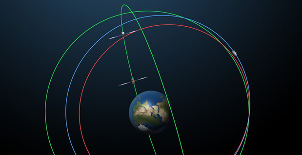
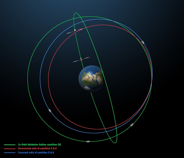
    The original (in red) and corrected (in blue) orbits of the fifth and sixth Galileo satellites, along with that of the first four satellites (green). Photo: European Space Agency
    The original (in red) and corrected (in blue) orbits of the fifth and sixth Galileo satellites, along with that of the first four satellites (green). Photo: European Space Agency

    By the European Space Agency

    The sixth Galileo satellite of Europe’s navigation system has entered its corrected target orbit, which will allow detailed testing to assess the performance of its navigation payload.

    Launched with the fifth Galileo last August, its initial elongated orbit saw it traveling as high as 25,900 km above Earth and down to a low point of 13,713 km — confusing the Earth sensor used to point its navigation antennas at the ground.

    A recovery plan was devised between ESA’s Galileo team, flight dynamics specialists at ESA’s ESOC operations centre and France’s CNES space agency, as well as satellite operator SpaceOpal and manufacturer OHB. This involved gradually raising the lowest point of the satellites’ orbits more than 3500 km while also making them more circular.

    The fifth Galileo entered its corrected orbit at the end of November 2014. Both its navigation and search and rescue payloads were switched on the following month to begin testing. Now the sixth satellite has reached the same orbit, too.

    This latest salvage operation began in mid-January and concluded six weeks later, with 14 maneuvers performed in total. Its corrected position is effectively a mirror image of the fifth satellite’s, placing the pair on opposite sides of the planet. The exposure of the two to the harmful Van Allen Belt radiation has been greatly reduced, helping to ensure future reliability.

    Significantly, the corrected orbit means they will overfly the same location on the ground every 20 days. This compares with a standard Galileo repeat pattern of every 10 days, helping to synchronize their ground tracks with the rest of the constellation.

    The test results from Galileo 5 proved positive, with the same test campaign for the sixth satellite due to begin shortly, overseen by ESA’s Redu centre in Belgium. A 20 m-diameter antenna will study the strength and shape of the navigation signals at high resolution.

    “I am very proud of what our teams at ESA and industry have achieved,” says Marco Falcone, head of Galileo system office. “Our intention was to recover this mission from the very early days after the wrong orbit injection. This is what we are made for at ESA.”

    The decision whether to use the two satellites for navigation and search-and-rescue purposes will be ultimately taken by the European Commission, as the system owner, based on the in-orbit test results and the system’s ability to provide navigation data from the improved orbits.

    The next pair of satellites is due for launch on March 27.

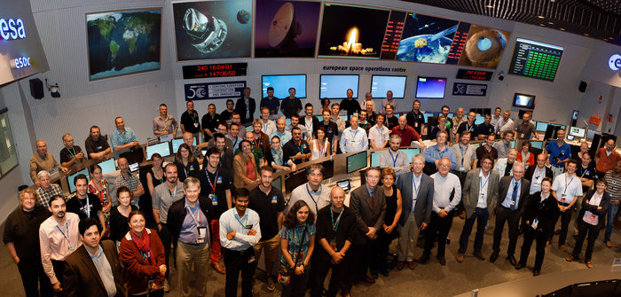
    The Galileo operations team, joined by Director General Jean-Jacques Dordain, Director of Human Spaceflight and Operations Thomas Reiter and experts from European industry, in the Main Control Room at ESA’s Space Operations Centre, ESOC, in Darmstadt, Germany, August 28, 2014. (Photo courtesy of ESA)
    The Galileo operations team, joined by Director General Jean-Jacques Dordain, Director of Human Spaceflight and Operations Thomas Reiter and experts from European industry, in the Main Control Room at ESA’s Space Operations Centre, ESOC, in Darmstadt, Germany, August 28, 2014. (Photo courtesy of ESA)
  • Trimble Introduces Correction Service for Agriculture in Europe 

    Trimble Introduces Correction Service for Agriculture in Europe 

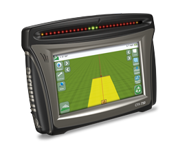
    The Trimble CFX-750 display. Photo: Trimble
    The Trimble CFX-750 display. Photo: Trimble

    Trimble announced today a new version of its CenterPoint RTX correction service that delivers convergence to 4-centimeter horizontal accuracy in less than 5 minutes. The service is designed for a variety of precision agriculture operations in Central and Western Europe, and is available for use with the Trimble CFX-750 display.

    Trimble CenterPoint RTX delivers highly accurate GNSS corrections via satellite without the need for traditional reference station RTK infrastructure, mobile data plans or additional on-machine hardware. The GNSS-enabled correction service delivers repeatable, real-time high-accuracy positions for land preparation, planting, harvesting and other high-precision farming applications.

    Enabled by the new version of RTX technology, RTX version 5.0, the fast convergence time is the result of a new region-specific atmospheric model and a dense ground reference station network. Growers will realize an approximate 80 percent improvement in RTX convergence time as compared to the RTX-standard service that typically provides 30-minute convergence time, Trimble said.

    Delivered via a new satellite broadcast covering western and central Europe, the new service will be available in Austria, Belgium, Czech Republic, France,Ireland, Germany, Luxembourg, the Netherlands, Western Poland, Southern Sweden and the United Kingdom.

    “We are continually advancing our Trimble RTX technology to improve productivity in the field,” said Patricia Boothe, general manager of Trimble Positioning Services. “Faster initialization times allow growers to start working more quickly, freeing up time to focus on other farm operations. No other satellite-delivered correction service today can offer better than 4 centimeter accuracy in less than 5 minutes.”

  • Launch Prep on Track for Galileo’s Next FOC Satellites

    Launch Prep on Track for Galileo’s Next FOC Satellites

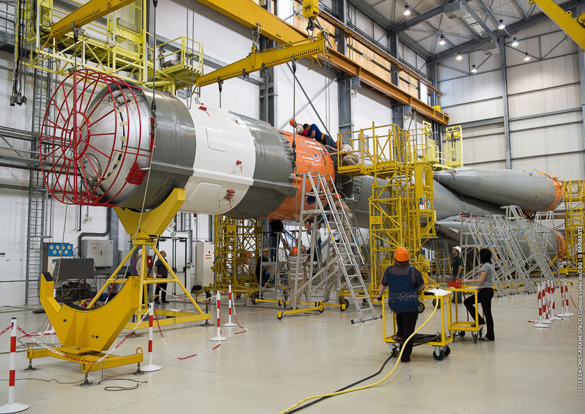
    Soyuz’ Block I third stage is mated to the launcher at the Spaceport’s MIK integration building.
    Soyuz’ Block I third stage is mated to the launcher at the Spaceport’s MIK integration building. Photo: Galileo

    Preparations for Arianespace’s next Soyuz flight, which will lift into orbit two more Galileo satellites, are in full swing at multiple locations across the spaceport in French Guiana. Work includes a key integration step for the medium-lift launcher, plus the start-up of fueling for its Galileo satellite passengers.

    Soyuz’ Block I third stage was mated to the vehicle’s core during activity today in the MIK Launcher Integration Building, concluding its basic build-up. Once the checkout process is completed, Soyuz will be transferred to the launch pad, where it will receive the two Galileo spacecraft and the Fregat upper stage, all of which are well into preparation phases of their own.

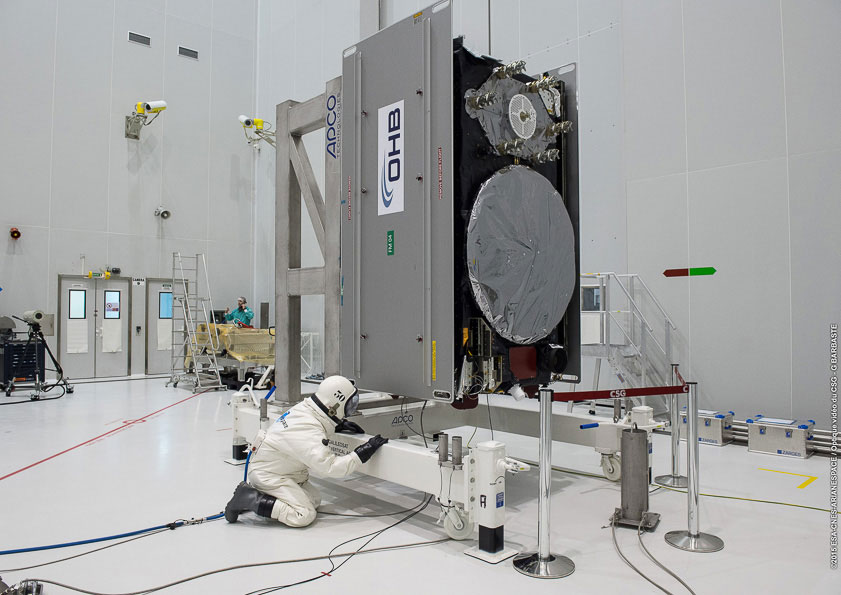
    Payload fueling began earlier this week, with Galileo 8 (Galileo FOC-FM4) — the fourth Galileo Full Operational Capability (FOC) satellite, and eighth overall — receiving its propellant load in the Spaceport’s S5A fueling and integration hall. After its sister Galileo FOC-FM3 (Galileo 7) co-passenger undergoes this same process, the two will be integrated side-by-side on a dispenser for their shared ride aboard Soyuz on March 27.

    The fueling process followed the finalization last week of FM3 and FM4’s hardware and software, as well as the charging of their batteries — which will be relied upon during the short period from launch to unfurling of these spacecraft’s solar arrays in orbit.

    The Galileo program is Europe’s initiative for satellite navigation, providing a highly accurate global positioning system under civilian control — to consist of 30 satellites in total, along with European control centers and a worldwide network of sensor and uplink stations.

    Galileo’s FOC phase — during which the network’s complete operational and ground infrastructure will be deployed — is managed and funded by the European Commission, with the European Space Agency delegated as the design and procurement agent on the Commission’s behalf.

    The FM3 and FM4 spacecraft were built by OHB System in Bremen, Germany. Their navigation payloads, which will generate the precision positioning measurements and services to users worldwide, were supplied by Surrey Satellite Technology Ltd. in Guildford, UK.

    This upcoming mission is designated Flight VS11 in Arianespace’s numbering system. It will be the company’s fourth launch carrying spacecraft for the Galileo constellation, as well as the 11th flight of a workhorse Soyuz from French Guiana since the 2011 introduction.

    the fourth Galileo Full Operational Capability (FOC) satellite is loaded with on-board propellant inside the S5A fueling and integration hall. Photo: Galileo
    the fourth Galileo Full Operational Capability (FOC) satellite is loaded with on-board propellant inside the S5A fueling and integration hall. Photo: Galileo
  • Report on Indian GPS Market Looks at Next 5 Years

    Feedback Business Consulting has released a report on opportunity in the Indian GPS current market scenario, structure and practices.

    The market scenario in “Opportunity in the Indian Global Positioning System (GPS) Market — 2015” includes current market size estimates by players, top companies, product categories, end user segments and regions. The product categories include tracking and navigation; segments include automobile, logistics, IT, ITe and mobile phones.

    The market structure section details the value of key players’ presence across products and end user segments. The market practices section explores understanding the GPS market sets in business, market trends, distribution practices and pricing.

    Some of the key companies featured in the report include Aadhithya Systems, Blaupunkt India, Caska India, Garmin India, Google Maps India and Locationguru.

    The report also provides a snapshot of key competition and past market trends with a forecast over the next five years. Anticipated growth rates and the factors driving and impacting growth are also provided.

    Market data and analytics have been derived from a combination of primary and secondary sources.

    More details and table of contents about this report can be found at Research and Markets’ website.

  • PPP Solution from NovAtel Improved for Sub-Decimeter Accuracy

    NovAtel has announced significant performance improvements to its precise point positioning (PPP) solution. NovAtel CORRECT with PPP will now offer the new TerraStar-C correction service as its exclusive source for satellite-delivered PPP correction data.

    TerraStar-C contains an enhanced correction data set that enables up to 4-centimeter accuracy and instant re-convergence when combined with the receiver error models and positioning algorithms offered by NovAtel CORRECT. This new level of PPP performance is available on NovAtel’s OEM6 receivers with firmware version 6.600.

    NovAtel CORRECT is the positioning algorithm on NovAtel’s GNSS receivers that handles corrections from a variety of sources, including real-time kinematic (RTK), PPP, spaced-based augmentation systems (SBAS) and differential GPS (DGPS). NovAtel CORRECT with PPP combines GNSS satellite clock and orbit correction data from TerraStar’s global reference station network with NovAtel’s receiver algorithms to yield robust sub-decimeter positioning without the need for nearby base stations.

    Correction data provided by TerraStar is delivered to the end user via Inmarsat satellites. With satellites visible globally, PPP is an ideal solution for precision applications where communications infrastructure is either unreliable or not available. In addition, applications where signal interruptions are common will benefit from a more robust positioning solution with the ability to quickly regain full accuracy following a temporary loss of GNSS signals, NovAtel said.

    NovAtel customers with current TerraStar-D subscriptions have the option to upgrade to the new TerraStar-C service level free of charge. The new NovAtel PPP performance level is available immediately.

  • Orbit of Second Wayward Galileo Satellite Adjusted

    Editor’s Note: See the report from the European Space Agency here.


    An official with the European Space Agency has confirmed that the sequence of maneuvers to adjust the orbit of the second of two Galileo satellites launched into a wrong orbit in August 2014  has been completed.

    The orbit of the first satellite, known variously as GSAT0201, Galileo FOC-FM1 or Galileo 5 (with COSPAR ID 2014-050A and NORAD ID 40128) was raised during operations carried out in November, and the satellite began transmitting L-band signals on Nov. 29.

    Maneuvering of the second satellite (GSAT0202, Galileo FOC-FM2 or Galileo 6, with COSPAR ID 2014-050B and NORAD ID 40129) began around Jan. 15. The procedure took somewhat longer than that for the first satellite as it also involved changing the mean anomaly of the satellite to be about 180° away from that of the first satellite.

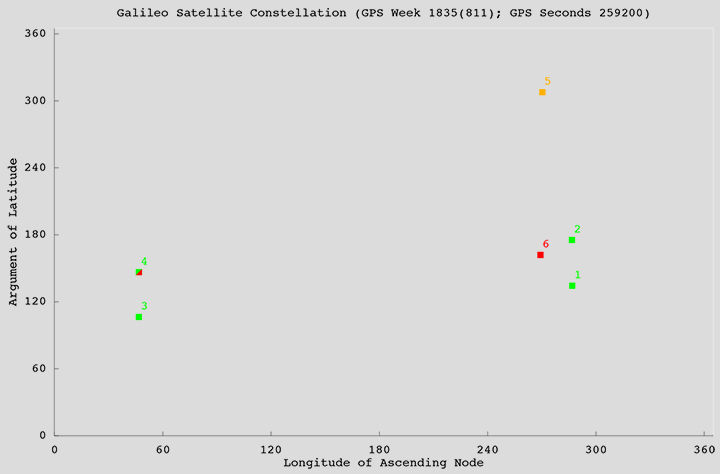
    The locations of the satellites in the Galileo constellation are shown in the accompanying figure. Satellites in green are transmitting a full complement of L-band signals. Galileo 4 (GSAT0104), one of the in-orbit validation satellites, suffered a power anomaly and only transmits on the E1 frequency. Galileo 5 is transmitting L-band signals but its orbit cannot be properly represented in the Galileo broadcast almanac. Galileo 6 has not started transmitting valid L-band signals yet.

    Officially, all Galileo signals are currently declared unavailable during an extended period of testing following ground segment upgrades. However, signals continue to be monitored by stations participating in the International GNSS Service Multi-GNSS Experiment.

    galileo_constellation-rev