Blog

  • GEO Business 2015 Returns for Second Year

    geo_business2015_logo_TFollowing its debut in 2014, GEO Business returns to The Business Design Centre in London on May 27-28.

    GEO Business 2015 combines a central trade exhibition with a conference program with 50 presentations and 140 live commercial workshops.

    The presentations and workshops, which provide first-hand demonstrations, have grown in number by 34 percent over the first year. Also larger this year is the exhibit space, by 64 percent, organizers said. The exhibit features more than 200 exhibitors showcasing the latest geospatial technology and services.

    The show’s unifying vision is to promote closer collaboration across the geospatial community and to provide a platform that effectively showcases both the professionalism of this industry and the role that it will play in future economic growth. It was born out of consultation with industry and as a result is organized in collaboration with the Chartered Institution of Civil Engineering Surveyors (ICES), the Royal Institution of Chartered Surveyors (RICS), The Survey Association (TSA), the Association for Geographic Information (AGI) and more recently the Institution of Civil Engineers (ICE).

    In 2014, more than 1,600 attendees from 39 countries took part. Learn more at the conference website.

  • FAA Gives Amazon Go-Ahead for Delivery Drone Tests

    Amazon-drone-O

    The Federal Aviation Administration has issued an experimental airworthiness certificate to an Amazon Logistics, Inc. unmanned aircraft (UAS) design that Amazon will use for research and development and crew training. Amazon has said it wants to use drones for delivering packages to customers.

    The FAA typically issues experimental certificates to manufacturers and technology developers to operate a UAS that does not have a type certificate.

    Under the provisions of the certificate, all flight operations must be conducted at 400 feet or below during daylight hours in visual meteorological conditions. The UAS must always remain within visual line-of-sight of the pilot and observer. The pilot actually flying the aircraft must have at least a private pilot’s certificate and current medical certification.

    The certificate also requires Amazon to provide monthly data to the FAA. The company must report the number of flights conducted, pilot duty time per flight, unusual hardware or software malfunctions, any deviations from air traffic controllers’ instructions, and any unintended loss of communication links. The FAA includes these reporting requirements in all UAS experimental airworthiness certificates.


  • Airbus Imagery to Help Vanuatu in Wake of Cyclone

    Port Vila, the capital of Vanuatu, viewed by Pléiades satellites, before Cyclone Pam.
    Port Vila, the capital of Vanuatu, viewed by Pléiades satellites, before Cyclone Pam.
    Port Vila, the capital of Vanuatu, viewed by Pléiades satellites after the passage of Cyclone Pam.
    Port Vila, the capital of Vanuatu, viewed by Pléiades satellites after the passage of Cyclone Pam.

    Following Cyclone Pam, Airbus Defence and Space has acquired Pléiades and SPOT 6 and 7 imagery over the island nation of Vanuatu to support the International Charter and Copernicus Emergency Management Service.

    The data acquired will assist in assessing the damage and help rescue organizations in the delivery of humanitarian aid.

    The before and after Pléiades images over Port Vila, that can be downloaded here, show the devastation caused by the cyclone. The “before” Pléiades image was acquired on April 9, 2014, and the “after” Pléiades image was acquired on March 16, three days after the Cyclone hit Port Vila.

  • Trimble’s Southard Elected to MAPPS Board

    MAPPS, an association of private-sector geospatial firms, has elected George Southard of Trimble Navigation Limited to the MAPPS Board of Directors, representing the association’s associate members.

    At its winter conference in January, the MAPPS membership approved a change to the association’s bylaws to create a non-voting, ex officio seat on the board, to be elected by and from associate member firms. Southard is the first to hold the seat, having been elected by his fellow associate members earlier this month.

    MAPPS is the a national association of firms in the surveying, spatial data and geographic information systems field in the United States. MAPPS member firms are engaged in surveying, photogrammetry, satellite and airborne remote sensing, aerial photography, hydrography, aerial and satellite image processing, GPS and GIS data collection and conversion services. Associate members include firms that provide products and services to member firms, as well as other firms worldwide.

    Southard has been an active participant in MAPPS since 1993. He’s served on various committees and presented at MAPPS conferences. He has served on the MAPPS Membership, Aerial Acquisition, Program and Associate Members Committees. He has been chair of the Associate Members Committee and most recently as the chair of the UAS Sub-committee to the Aerial Acquisition Forum. Southard has been on the association’s Nominations Committee for several MAPPS Board elections and was the MAPPS representative to the ASPRS Frank Moffitt Memorial Scholarship Committee.  

    “We’re pleased to have George join the board,” said MAPPS President Jeff Lower (Precision Aerial Reconnaissance, LLC). “He is a recognized leader in our profession and will bring a valued and respected voice to MAPPS and our board.”

  • Navitel Offers Navigation Map of India

    Navitel Offers Navigation Map of India

    Navitel_India
    Photo: Navitel

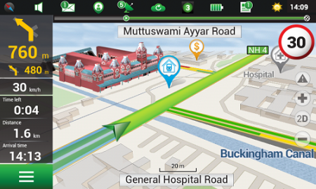
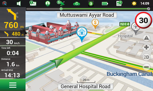
    Navitel’s navigation map of India is now available for purchase, for use with the Navitel Navigator GPS & Maps app on Google Play. Navitel Navigator is a precise offline GPS navigation with free geosocial services and detailed maps of 59 countries, with 20 million downloads worldwide.

    The map of India contains 2,092,013 km of road graph, 594 627 cities, towns, and other settlements, as well as 5,294,344 POI. Coupled with the address search in more than 6 000 residential and industrial areas of settlements, this map includes the detailed housing system data with due account for the number of floors, detailed road networks with all streets, roads, and indicated traffic direction, road interchanges, roundabouts, and other important road information.

    The map contains 149 3D points of interest, including:

    • Delhi – Akshardham Temple, Qutub Minar, Laxmi Narayan Mandir, and Lotus Temple.
    • Gujarat – ISCON Mall, Satyam Centre, the Metropole Hotel, Kaizen Hospital.
    • Karnataka – Bangalore Palace, Software Technology Park of India, Jamia Masjid, Hotel Savannah Sarovar Premiere, Jawahar Bal Bhawan park.
    • Tamil Nadu – Chennai International Airport, Chennai Railway Station, Manorama Hotel, Lemon Tree Hotel.
    • Haryana – Vardhman Star Mall, YMCA University of Science and Technology, Mini Secretariat, Sarvodaya Hospital, Gurgaon Centre.
    • Chandigarh – Panjab University, Chandigarh College of Engineering & Technology, Haryana and Punjab Secretariat, Hotel Royal Plaza.

    Details for Map of India, Q1 2015:

    • 2,092,013 km of road graph;
    • 594,627 settlements on the map;
    • 6,614 settlements allowing the address search;
    • 8,217,526 addresses;
    • 149 3D points of interest;
    • 5,294,344

    Android OS device users can purchase a license key to the new product at Google Play and from the program menu by selecting “My Navitel” > “Purchase maps”.

    The Q1 2015 map of India is compatible only with 9.1.0.0 and later versions of Navitel Navigator.

  • MemSQL Brings Geospatial Analysis to In-Memory, Distributed Databases

    MemSQL, which specializes in real-time databases for transactions and analytics, has announced new geospatial capabilities for its in-memory, distributed SQL-based database. By bringing together geospatial and operational data in the same high speed database, customers can achieve unprecedented agility for geospatial analysis, MemSQL said.

    Unlike segregated solutions, MemSQL integrates geospatial data as a primary data type, making it as easy to use and operate at scale with as much speed and high throughput as any other class of data.

    Previously, enterprises were forced to segregate their geospatial data into separate data stores. With the rise of IoT and mobility, nearly all data is location-specific. As data volume increases, maintaining geolocation information outside of the primary datastore leads to longer latency and synchronization challenges.

    By integrating geospatial functions, MemSQL enables enterprises to achieve greater database efficiency with a single database that is in-memory, linearly scalable and supports the full range of relational SQL and geospatial functions. With MemSQL, geospatial data no longer remains separate and becomes just another data type with lock-free capabilities and powerful manipulation functions.

    Taxi Scenario with Esri. Working with MemSQL and Apache Spark, Esri analyzed data compiled from 170 million real-world New York City taxi rides around the GPS coordinates of pickups and dropoffs, as well as distance and travel time. Slicing by hour of the day, Esri can calculate the average speed of a taxi ride and find the best and worst places for traffic jams. Slicing by day of the week, the ebb and flow of traffic during workdays and weekends becomes visible.

    For a city planner, this data insight can be used to redirect traffic at specific times in an effort to unclog traffic congestion. For the taxi business, this data can improve efficiency with supply and demand of cabs during times of high or low traffic for any given region.

    “MemSQL is enabling companies to consolidate many niche solutions into fewer, more capable multi-purpose solutions. By making geospatial data a primary part of in-memory, operational databases, our customers can rely on one solution to make their data more valuable,” said Eric Frenkiel, MemSQL co-founder and CEO. “We’re delivering on our promise of easy access to database innovation and are quickly becoming the go-to-company to help enterprises operationalize analytics.”

    MemSQL will showcase the MemSQL, Apache Spark and Esri demonstration at Spark Summit East 2015 on March 18-19 at The Sheraton New York Times Square Hotel. Visit MemSQL at Booth 13 during show expo hours.

    The early access MemSQL geospatial capabilities are available now and will be generally available in calendar Q2. Read the technical blog post here.

  • PocketGIS for Android Now on Available

    Pocket Systems Ltd. has released PocketGIS for AndroidPocketGIS is a professional mobile geographical information system for field data capture and surveying, which can capture and edit map geometry and enter data using forms.

    PocketGIS runs on Android 4.0 and later and is designed for tablet and handheld screens.

    GPS/GNSS. PocketGIS can be linked to a device’s internal GPS or GNSS receiver, or an external receiver via Bluetooth. This provides real-time location tracking and data capture. The GPS position is projected to the chosen coordinate system in real time offering instant verification of survey results.

    The GPS trail function specifies a time or distance interval to automatically create points from the current GPS position. This let’s users capture points automatically while walking a line or route. Advanced settings allow filtering of GPS quality to ensure the accuracy of captured points. Users can also take an average of a number for GPS position readings and compensate for antenna heights. National grid datum corrections are supported, and these are added on request (such as OSTN02, ETRS89, RH2000 and OSGM02).

    PocketGIS can be connected to a laser rangefinder or total station and provides a comprehensive set of laser survey functions. The laser functions integrate with GPS to survey offset positions and calculate height differences. Photographs can be taken from within the data-collection form using the device’s built-in camera to link the picture to captured points, lines or areas.

    Edit, Measure, Search. Users can tap on points, lines areas or text (features) to display and update information. Users can measure distances or areas and display grid references, move points and edit lines, and search for data by type or value.

    Data Exchange. PocketGIS can import and export data from cloud services such as Dropbox or Google Drive or via email. Shape, Comma Separated Values (CSV) and TIFF raster are supported. Additional formats will be supported in the future. Users can specify capture features, design data capture forms and customize imported data from within the application. No additional software or servers are required.

    PocketGIS was first released in 1997 or the Newton MessagePad. Having run on a succession of Windows CE devices, PocketGIS has evolved again and is now available for Android.

    For more information and a demo version of the software, go to http://www.pocketgis.com/android.

  • AgJunction to Acquire Novariant

    Precision-agriculture company AgJunction has agreed to acquire precision-steering company Novariant, according to a joint press release.

    AgJunction holds numerous patents and markets its products and services under the brand names Outback Guidance, Satloc and AgJunction Cloud Services. AgJunction supports advanced farming practices and enables seamless data connectivity among growers and their agricultural service providers. Headquartered in Hiawatha, Kansas, AgJunction has facilities in Arizona, Pennsylvania, Winnipeg, and Queensland, Australia.

    Based in Silicon Valley, Novariant’s steering solutions are used in more than 60 countries. With 55 employees worldwide, Novariant generated revenues of approximately $30 million in 2014. Novariant offers interoperable auto-steer capabilities to original equipment manufacturers (OEMs) and value-added resellers worldwide with more than 750 unique platform-install kits and more than 30,000 systems in the field.

    According to the statement, when combined the two companies will be better positioned to achieve market objectives through leveraging:

    • A larger presence with more resources
    • A broader OEM partner list
    • One of the precision agriculture industry’s most comprehensive intellectual property portfolios, providing increased IP protection for OEM partners
    • Increased R&D capability and efficiency
    • Complementary customers, market geographies and distribution channels
    • Reductions in operating redundancy to further improve profitability.

    Completion of the transaction is expected to take place this summer.

    “Novariant established itself as a pioneer in guidance and auto-steer technologies over 20 years ago,” said Dave Vaughn, CEO of Novariant. “Most recently, Novariant has sharpened its focus on precision agriculture and has positioned its offerings to address a major shift in our industry from after-market channels to factory-installed solutions.”

    “A shift like this occurs only once during the lifecycle of a technology, and great companies can be created by accelerating and innovating at the right time,” added Vaughn. “At Novariant we believe this is a transformational opportunity, and AgJunction is the right partner.”

    As global machine manufacturers increasingly target the integration of auto steer technologies at the factory level, the combined companies can bring advanced levels of machine automation to both current and future OEM clients faster and at lower cost.

    “The combination of Novariant and AgJunction creates an exciting opportunity for our company, for our customers, and for our shareholders,” said Rick Heiniger, president and CEO of AgJunction. “This merger extends the reach and influence with which we pursue a common passion — delivering the most accurate, innovative and reliable steering solutions in the world.”

    Once the merger is complete, the combined company will have approximately 200 employees worldwide and will be headquartered at Novariant’s corporate headquarters in Silicon Valley. The combined company plans to maintain additional offices in Kansas, Arizona, Pennsylvania, Canada and Australia.

    Dave Vaughn, CEO of Novariant, will be appointed CEO of the combined company, with current AgJunction CEO Rick Heiniger serving as senior advisor to the CEO. In addition, Wes Dittmer will continue to serve as the combined company’s CFO.

     

  • BeiDou Launch May Take Place This Month

    BeiDou Launch May Take Place This Month

    News courtesy of the CANSPACE Listserv.


    The first satellite in the BeiDou Phase 3 expansion could be launched by the end of March. Apparently, a BeiDou satellite has been shipped to the Xichang launch site, and tracking ships have left port for the open ocean.

    Also, a philatelic first-day cover for the launch (a common Chinese practice) has been issued with a March 2015 inscription. This is likely a launch of a medium Earth orbit (MEO) satellite.

    The new BeiDou satellite would be the fifth GNSS satellite planned for launch by the end of the month, joining GPS Block IIF-9 (March 25), Galileo 7 and 8 (March 27) and IRNSS-D (March 29).

    Below is the first-day cover.

    BDS-3_M1_launch_cover.jpg
    First-day stamp cover for BeiDou commemorates an upcoming MEO launch. Photo: BeiDou


  • CNAV Performance ‘Matches or Slightly Outperforms’ Legacy Signals

    CNAV_Performance Chart_10_Mar_2015_public

    A quarterly meeting of the U.S. GPS Program’s interagency Civil Navigation Signals (CNAV) Tiger Team on March 5 focused on the new L2C and L5 GPS civil signals. “CNAV Message Types 10, 11, 30 and 33 are currently transmitted on seven GPS IIR-M (L2C) and eight GPS IIF satellites (L2C and L5),” wrote Rick Hamilton, CGSIC Executive Secretariat, USCG Navigation Center, in a status email to the Civil Global Positioning System Service Interface Committee (CGSIC).

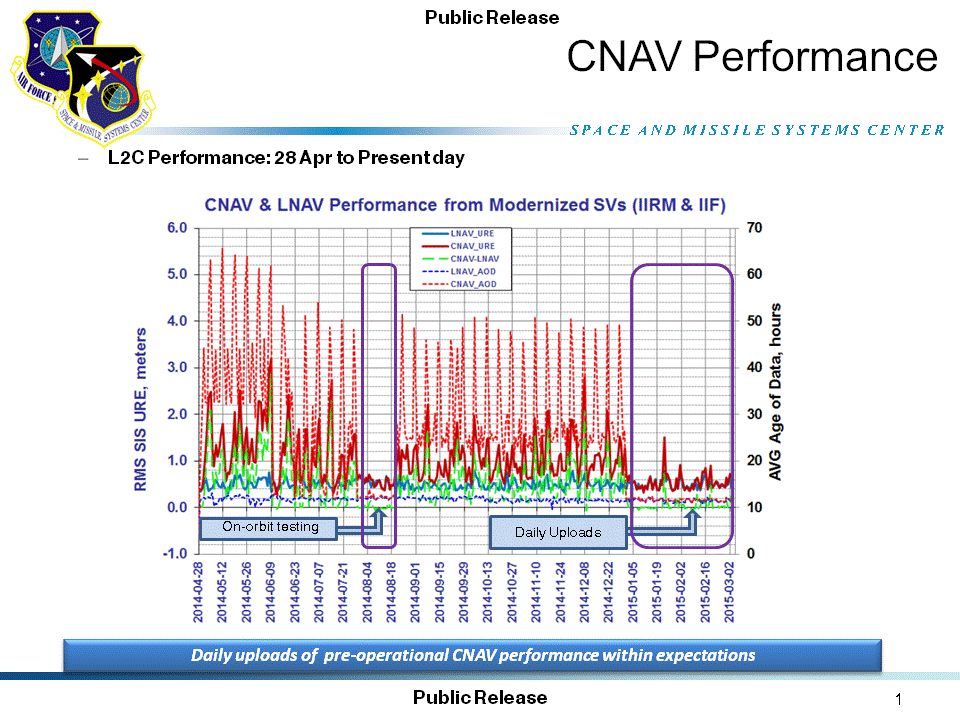
    “A Modernized Navigation (MODNAV) Tool integrated with the GPS ground control software (Architecture Evolution Plan or AEP) is generating the CNAV data messages,” Hamilton wrote. “Daily CNAV uploads began December 31, 2014, and the U.S. Air Force reports that signal performance of CNAV matches or slightly outperforms Legacy performance: average user range error (RMS URE) from 25 February – 3 March 2015 was 0.50 m for Legacy and 0.57 m for Modernized; best week for Modernized signals since the broadcast initiated April 2014 was 0.42 m for 6 – 13 January 2015.

    The graph above, from the Coast Guard Navigation Center website, illustrates the CNAV performance.

    Users are reminded that these CNAV signals are ‘pre-operational’ and should be used with discretion until they become fully operational; the L5 message is currently set unhealthy,” Hamilton concluded.

  • Fugro Offers High-Accuracy Offshore Positioning Service

    Fugro has introduced its high-accuracy G2+ service, designed to benefit offshore operators around the globe who require positioning and measurement accuracy at centimeter level.

    G2+ is an enhancement of Fugro’s G2 service (based on GPS and GLONASS). The service uses highly advanced GNSS augmentation algorithms developed in house. The code and carrier-phase signals transmitted by GPS and GLONASS satellites are monitored globally by Fugro’s worldwide network of reference stations.

    These observations are processed centrally in real-time using the company’s proprietary algorithms to generate precise corrections which are used to augment the standard signals broadcast by GPS and GLONASS satellites.

    Customers receive corrections via seven high-powered communications satellites, providing at least two independent G2+ data sources. The new satellite positioning service will be particularly beneficial when seeking to measure latitude, longitude, elevation and speed with high accuracy in real-time, Fugro said.

    Applications include offshore construction, survey services, vessel monitoring and structural monitoring. The ultra-high accuracy enables the real-time correction of tidal changes — which impact the accuracy of seabed mapping — as well as the real-time monitoring of the motion of floating and fixed structures.

    The 3D accuracies of the system approach those of GNSS RTK (real-time kinematic) systems while avoiding the need for an RTK base station or local transmission link, overcoming the logistical challenges and range limitations associated with coastal RTK systems, Fugro said.

    The launch of G2+ follows the recent launch of Fugro’s G4 satellite correction service, which takes advantage of all four global navigation satellite systems: GPS, GLONASS, BeiDou and Galileo.

  • Galileo at Your Service


    On the eve of the Galileo 7 and 8 launch, the European Space Agency has created a short video to explain the value of the satellite constellation to its citizens. With the Galileo System, Europe will provide a full range of services and applications across many different areas for Europe and beyond.