Blog

  • FAA Warns Drone Hobbyist and YouTuber

    So, you know it’s illegal to fly drones in the United States for commercial purposes unless you have a Federal Aviation Administration (FAA) exemption and Certificate of Authorization and Waiver (CoA), right?

    That means you can’t fly drones if it’s related to business, no matter if you charge a fee or not. But, you can fly drones in the United States as a “hobbyist” as long as you adhere to certain rules (such as flying lower than 400 feet above the ground).

    In a new twist, the FAA has cracked down on at least one person who posted a drone video on YouTube because YouTube generates revenue, reports the website Motherboard. Even though it appears the drone was being flown by a hobbyist for recreational purposes, it smells to the FAA like a commercial use of drone. Even though the hobbyist isn’t generating revenue from it, Google is.

    Jason Hanes' Youtube Channel
    Jason Hanes’ YouTube channel.

    While it appears the U.S. drone community is going nuts using drones for all kinds of non-commercial and commercial purposes, despite the FAA rules, it appears there are too many violators for the FAA to chase after since enforcement notices sent by the FAA have been few and far between. In this case, safety concerns may have been the prompt. The FAA says it’s now looking further into how its safety inspectors send letters like this. Read more about the case at the Motherboard website.

    Geospatial Data Interest Crosses Political Party Lines

    Senator’s Mark Warner (D-Va.) and Orrin Hatch (R-Utah) introduced the Geospatial Reform Act, targeted at leveraging geospatial data acquired by the U.S. federal government. This bill argues that the federal government is the largest purchaser of geospatial data, yet agencies aren’t required to report details of geospatial data purchased. The bill aims to change that.

    “Geospatial data has endless possibilities for transforming both the private and public sectors — from helping local governments develop emergency preparedness plans to fueling the creation of apps that let you find parking spots, restaurants, and even homes for sale based on where you’re standing,” said Sen. Warner. “The federal government is the largest purchaser of geospatial data but some very basic questions about how and where agencies are already investing in this data can’t be answered. Our bill would bring transparency and accountability to the collection of this data and ensure that taxpayer dollars are not being wasted on duplicative efforts.”

    Sen. Warner and Hatch issued a joint statement about the bill.

    DigitalGlobe Offers Commercial 30-cm Resolution Satellite Imagery

    In what DigitalGlobe claims is a world’s first, the company began offering commercial 30-cm satellite imagery via its WorldView-3 satellite, which was launched August 13, 2014. DigitalGlobe announced that the imagery is available worldwide (with some restrictions). As part of its press release, DigitalGlobe offered the following quote from PhotoSat, a consumer of imagery.

    “DigitalGlobe’s WorldView-3 satellite data is the highest quality satellite photo data that PhotoSat has ever processed,” said Gerry Mitchell, President of PhotoSat, a leading satellite elevation mapping provider for energy, mining, and engineering firms. “In one test, an elevation mapping grid extracted from stereo WorldView-3 satellite photos matched a highly accurate LiDAR elevation grid to better than 15 cm in elevation. This result takes satellite elevation mapping into the engineering design and construction markets and directly competes with LiDAR and high resolution air photo mapping for applications like flood plain monitoring.”

    According to DigitalGlobe, WorldView-3 is the first and only commercial imaging satellite capable of collecting imagery with 30-cm ground sample distance, and claims it is five times the detail of the company’s nearest competitor. See a sample by clicking here.

    Satellite imagery is approaching aerial photogrammetry quality. I recall Lawrie Jordan, founder of ERDAS (sold to Leica) and now director of imagery at Esri, saying that eventually every square inch of the earth will be imaged constantly by satellite.

    Esri and Drone Data Up until now, you haven’t heard the words “Esri” and “drone” mentioned in the same sentence very often. Last week at the Esri Developer Summit in Palm Springs, Esri provided a live map-creation demo using a small quadcopter.

    Look for a follow-up article, data example and possibly a video of the event.

    Thanks, and see you next month.

    Follow me on Twitter at https://twitter.com/GPSGIS_Eric

  • DigitalGlobe Makes Available 30-cm Satellite Imagery to Customers

    DigitalGlobe-satellite-imagery-W

    DigitalGlobe is making available its 30-cm satellite imagery products. Access to the high-resolution commercial satellite imagery captured by DigitalGlobe’s WorldView-3 satellite will improve decision making, enable more efficient operations, and enhance a variety of applications for customers in the civil government, defense and intelligence, energy, mining and global development sectors.

    In addition, many customers who previously relied on aerial imagery can now benefit from the improved economics, global availability, and faster refresh rate that DigitalGlobe can provide with its 30-cm satellite imagery, the company said. Imagery of this resolution was previously only available from aerial platforms, which are difficult, costly, or impossible to access in many parts of the world.

    DigitalGlobe’s 30-cm imagery products are also a rapid and affordable alternative in locations where aerial imagery is readily available. New imagery orders can be delivered on timescales of days or weeks, as opposed to months, in many cases, and customers can also have access to a rapidly growing volume of available 30-cm archive imagery.

    The suitability of 30-cm satellite imagery for aerial imaging applications is confirmed by the National Imagery Interpretability Rating Scale (NIIRS), which is used by the imaging community to define and measure the quality of images and performance of imaging systems. DigitalGlobe’s 30-cm imagery achieves a rating of NIIRS 5.7, meaning it can resolve objects on the ground such as above-ground utility lines in a residential neighborhood, manhole covers, building vents, fire hydrants, and individual seams on locomotives.

    “DigitalGlobe’s WorldView-3 satellite data is the highest quality satellite photo data that PhotoSat has ever processed,” said Gerry Mitchell, president of PhotoSat, a satellite elevation mapping provider for energy, mining and engineering firms. “In one test, an elevation mapping grid extracted from stereo WorldView-3 satellite photos matched a highly accurate LiDAR elevation grid to better than 15 cm in elevation. This result takes satellite elevation mapping into the engineering design and construction markets and directly competes with LiDAR and high-resolution air photo mapping for applications like flood plain monitoring.”

    The DigitalGlobe’s WorldView-3 commercial imaging satellite is capable of collecting imagery with 30-cm ground sample distance — five times the detail of the company’s nearest competitor. The satellite also features unique shortwave infrared (SWIR) capabilities that will enable new applications such as seeing through smoke and haze, identifying minerals and manmade materials, and assessing the health of crops and vegetation.

    The SWIR imagery that the satellite collects has never before been available to commercial customers with this level of spatial and spectral resolution, and it will provide unique value to users in the energy and mining industries, as well as others, DigitalGlobe said. DigitalGlobe also launched a beta program for 7.5 m SWIR imagery, working with partners, customers and users to explore new uses for this capability.

    “Companies should be exploiting the competitive advantages of the WorldView-3 data to look for potential ore-related alteration that will have been missed by the previous satellites used for alteration mapping,” said Dan Taranik, managing director of Exploration Mapping Group, a service provider to the global mineral exploration industry. “Detailed inspection of remote areas on the peripheries of alluvium or younger volcanics would be a competitive advantage that could help reveal concealed deposits.”

  • Rockwell to Provide Secure GPS Receivers for Harris Tactical Radios

    Rockwell to Provide Secure GPS Receivers for Harris Tactical Radios

    Rockwell Collins has signed a contract to provide its MicroGRAM GPS receivers (pictured here) for Harris Corporation’s tactical radios, bringing secure, jam-resistant GPS capability to products such as the Falcon III AN/PRC-158 and AN/PRC-117G.
    Rockwell Collins has signed a contract to provide its MicroGRAM GPS receivers (pictured here) for Harris Corporation’s tactical radios, bringing secure, jam-resistant GPS capability to products such as the Falcon III AN/PRC-158 and AN/PRC-117G.

    Rockwell Collins has signed a contract to provide its MicroGRAM GPS receivers for Harris Corporation’s tactical radios, bringing secure, jam-resistant GPS capability to products such as the Falcon III AN/PRC-158 and AN/PRC-117G.

    The contract, which represents the largest annual purchase of MicroGRAM, calls for Rockwell Collins to provide 5,000 GPS receivers to Harris over the next three years. Deliveries began in January.

    “MicroGRAM enables Harris Corporation to meet military customer demands for embedded, secure GPS,” said Mike Jones, vice president and general manager of Communication and Navigation Products for Rockwell Collins. “MicroGRAM protects warfighters from the growing jamming and spoofing threats on the battlefield, while enhancing survivability and mission success.”

    With this selection, Jones said Harris is one of the first major original equipment manufacturers to commit to using MicroGRAM to meet the Department of Defense’s (DoD) requirement to use Selective Availability/Anti-Spoofing Module (SAASM) technology in its products.

    “Harris is pleased to continue our long relationship with Rockwell Collins as our provider of GRAM SAASM GPS modules. Integrating the MicroGRAM receiver into a number of our new tactical radios allows us to reduce the size and weight while extending the battery life of our products,” said George Helm, president, Department of Defense business, Harris RF Communications. “The end result is delivering reliable situational awareness down to the individual warfighter.”

    MicroGRAM is the world’s smallest, lightest, lowest powered SAASM-based GPS receiver. It enables military micro-users who require secure Position, Navigation & Timing (PNT) to comply with U.S. DoD policy that all combat and combat support systems use SAASM-based GPS devices. This capability is critical at a time when threats to commercial GPS are increasing. The use of unprotected commercial non-SAASM GPS devices has inherent vulnerabilities which introduce a false sense of situational awareness on the battlefield.

  • Russian Company Credo-Dialogue Releases GNSS Software

    The Russian company Credo-Dialogue has released Credo GNSS 1.0, a GNSS processing software.

    Credo GNSS 1.0 is designed for processing of satellite geodetic measurements in differential mode. In this mode, the simultaneous operation of two or more receivers forms the baseline.

    The input can use the following types of data:

    • satellite geodetic measurements and ephemeris format RINEX (2.0-3.2);
    • satellite geodetic measurements and ephemeris formats satellite geodetic receivers (in accordance with the import module);
    • import point coordinates from text files in any format, user-configurable;
    • precise ephemeris (can be downloaded automatically to the time span of the project); and
    • raster image formats BMP, GIF, TIFF (GeoTIFF), JPEG, JPEG2000, PNG, CRF, ECW and RSW.

    Also in the program, users can view images from web services such as Google Maps, Bing and Express Kosmosnimki.

    Credo GNSS supports a variety of coordinate systems, including Transverse Mercator, Mercator, PseudoMercator, Lambert Conformal Conic and Orthographic.

    To learn more about the software, click here or view the video below.

    https://www.youtube.com/watch?v=zRmTB4GEhak

  • EGNOS-Africa Joint Programme Office Launched

    The SAFIR (Satellite navigation services for AFrIcan Region) project has officially launched the EGNOS-Africa Joint Programme Office, laying the first stone of its future office building in a ceremony in Dakar, Senegal.

    SAFIR is part of the Africa-EU long-term strategic partnership to enhance safety in air transport. Its global objective is to build capacity within African ACP countries for the future deployment of GNSS/EGNOS in the region. The three-year project is funded by the European Union and financed from the 10th EDF Intra ACP envelope with 3.7 million euros, under an international consortium led by ASECNA (Agence pour la Sécurité de la Navigation Aérienne en Afrique et à Madagascar) with Egis, Pildo Labs and ESSP.

    The ceremony took place in Dakar on March 3. Those attending included Matthias Petschke, EU Satellite Navigation Programmes director; Karolina Stasiak from the UE Delegation in Sénégal; and Amadou Ousmane Guittèye, director general of ASECNA.

    “Satellite navigation can bring huge societal benefits, be it in transport, in agriculture or land management,” Petschke said in remarks at the launch ceremony. “Satellite-based augmentation systems in particular, like EGNOS, can bring enormous social and economic benefits. I attach, therefore, great importance to the setting up of the EGNOS Africa Joint Programme Office and am particularly pleased to see this team of African experts who have extensive experience and knowledge to support the development of an African satellite based augmentation system.”

    In his speech, Guittèye said, “The first mission of the JPO is to ensure Africa has developed adequate competencies and then to coordinate the implementation of the development and of the deployment of GNSS/EGNOS services and applications in the continent. The EGNOS-Africa Joint Programme Office (JPO) is a pan-African entity that acts for the benefit of Africa and supports stakeholders in their GNSS/EGNOS strategy, developments and implementation.”

    The ceremony also was attended by officials from the International Civil Aviation Organisation (ICAO), the African Civil Aviation Commission (AFCAC), the Agence Nationale de l’Aviation Civile et de la Météorologie (ANACIM) , the Aéroports du Sénégal (ADS) and local authorities.

    The SAFIR project began on January 15, 2013. It covers the set-up, staffing and operations of an EGNOS-Africa Joint Programme Office, and sets up and supports a number of technical working sessions composed of regional stakeholders concerned with GNSS/EGNOS in sub-Saharan Africa.

    ASECNA has 18 member states. With air navigation safety as its main mission, it cooperatively manages African airspace for the countries of Benin, Burkina Faso, Cameroun, Central African Republic, Comoros, Congo, Côte d’Ivoire, France, Gabon, Guinea Bissau, Equatorial Guinea , Madagascar, Mali, Mauritania, Niger, Senegal, Chad and Togo.

  • GPS IIF-9 Prepped for March 25 Launch

    GPS IIF-9 Prepped for March 25 Launch

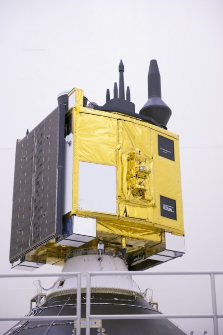
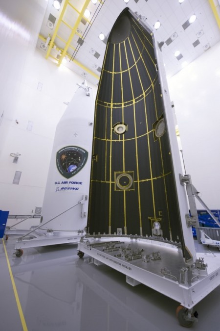
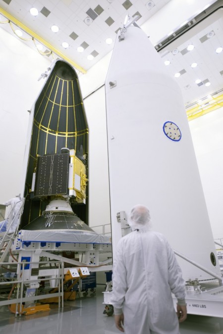
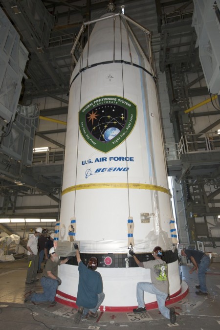
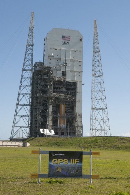
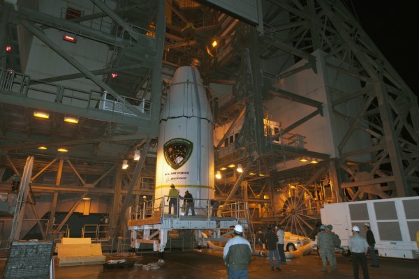
    The U.S. Air Force’s ninth GPS Block IIF satellite (GPS IIF-9) has been encapsulated in the Delta IV rocket’s four-meter-diameter nose cone at a processing facility, and moved to the launch pad at Space Launch Complex 37 for mating to its booster inside the mobile service tower.

    Launch is scheduled for March 25 at 2:36 p.m. EDT (1836 GMT) from Space Launch Complex 37 at Cape Canaveral Air Force Station, Fla. GPS IIF-9 marks the 29th Delta IV launch and the 57th operational GPS satellite to launch on a ULA or heritage launch vehicle.

    To follow the launch countdown, dial the ULA launch hotline at 1-877-852-4321 or join the conversation on Facebook, Twitter or Instagram.

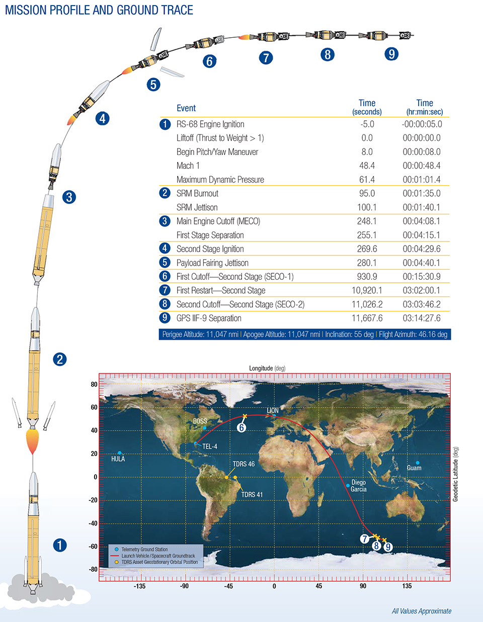
    GPS IIF-9 Mission profile and ground trace. (courtesy of ULA)
    The planned GPS IIF-9 launch trajectory, event times, and ground trace. (courtesy of ULA)

    Below are photos from the United Launch Alliance, which supplies the Delta IV rocket and serves as the launch provider for the GPS Directorate.


  • Galileo 6 Signals Acquired

    News courtesy of CANSPACE Listserv.

    On March 17, some stations participating in the International GNSS Service Multi-GNSS Experiment acquired E1 and E5a signals from Galileo 6 (FOC-FM2, GSAT0202). The satellite is using pseudorandom noise code E14.

    The orbit of Galileo 6 was recently adjusted to make it more circular with a higher perigee after it was launched into an incorrect orbit last August.

  • Galileo 7 and 8 Fitted to Dispenser in Preparation for Launch

    Galileo 7 and 8 Fitted to Dispenser in Preparation for Launch

    Artist's view of Galileo satellites attached to their dispenser atop their Fregat upper stage separating from the Soyuz upper stage. The Fregat then flies them the rest of the way up to medium-Earth orbit.  (courtesy of ESA)
    Artist’s view of Galileo satellites attached to their dispenser atop their Fregat upper stage separating from the Soyuz upper stage. The Fregat then flies them the rest of the way up to medium-Earth orbit. (courtesy of ESA)

    News courtesy of the European Space Agency

    The seventh and eighth Galileo satellites being fitted together onto the dispenser, March 16-17. (Photo courtesy of ESA)
    The seventh and eighth Galileo satellites being fitted together onto the dispenser, March 16-17. (Photo courtesy of ESA)

    The seventh and eighth Galileo satellites, set for launch together in nine days’ time, have been fitted together onto the dispenser that will carry them during their flight to orbit.

    The fueling of the two satellites was completed last week, leaving them ready to be placed into launch configuration. They were carefully lowered into place then attached to the dispenser. The operation went smoothly, the two satellites having previously gone through separate “fit checks” with the dispenser in advance of fueling.

    The specially designed carrier will hold the satellites in place during their four-hour flight into orbit some 22,300 km above our planet. Then, at the correct altitude, the two satellites are sprung away in opposing directions. Next, the dispenser plus satellites will be placed onto the Fregat upper stage of their Soyuz ST-B launcher.

    As much a spacecraft as a launch stage, the reignitable Fregat will haul the Galileo satellites most of the way up to their final orbital altitude, once the first three stages of the Soyuz have taken them up to their initial orbit.

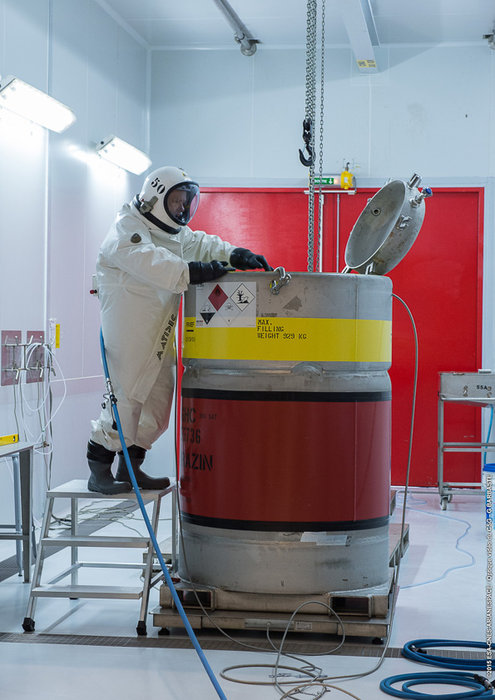
    Fuel for the seventh and eighth Galileo satellites, checked by an engineer in a protective SCAPE (Self Contained Atmospheric Protective Ensemble). Fuelling of the two satellites took place at the end of the second week of March 2015, allowing the satellites to be fitted to their launch dispenser ahead of the March 27 launch. (Photo courtesy of ESA)
    Fuel for the satellites is checked by an engineer in a protective SCAPE (Self Contained Atmospheric Protective Ensemble). (Photo courtesy of ESA)

    Note the protective metal panels covering the solar wings folded against the sides of the Galileo satellites. Protecting these delicate solar arrays during handling on the ground, these panels will be removed ahead of launch.

    The launch of the seventh and eighth Galileo satellites is scheduled for March 27.

  • Ride Service Uber Acquires Mapping Company DeCarta

    Ride service Uber is buying mapping and search startup deCarta, reports Mashable, which said it learned of the deal from an Uber representative.

    The deal was expected to close earlier this month. Uber plans to use deCarta’s technology and talent to fine-tune its products and services that rely on maps, including UberPOOL, the smartphone-based ride-sharing app.

    Thirty out of 40 deCarta employees will remain with the company, including Kim Fennell, chief executive officer and president, Mashable said. deCarta will continue to operate as a wholly-owned subsidiary of Uber, but will use its own name.

    Founded in 1996, deCarta is privately held, and headquartered in San Jose, Calif., with international offices and distributors in Germany, China, Brazil and South Africa. deCarta is a global location-based services (LBS) technology company that provides specialized geospatial technologies for online mapping, routing, navigation, geocoding, local search and geo-data integration and processing. The company’s platform is used by high-volume LBS applications and services in the mobile, Internet, enterprise-fleet and automotive markets.  Customers and technology partners include Samsung, Inrix, T-Mobile, FullPower MotionX GPS Drive, Appello, Denso, Ford, GM OnStar, Masternaut, Wireless Matrix, eMapgo, Nokia/HERE, Spot-On-Time, Telstra/Sensis, TomTom, WHERE/eBay.

    In February, Uber announced a partnership with Starwood Hotel and Resorts where Starwood Preferred Guest members earn points towards free hotel stays for every dollar spent riding Uber.


  • U.S. Senators Introduce Bipartisan Geospatial Data Act

    United States Senators Orrin Hatch, R-UT, and John Warner, D-VA, have introduced the bipartisan Geospatial Data Act in the U.S. Congress.

    “The federal government wastes vast amounts of taxpayer dollars by not properly managing and coordinating our federal investments in geospatial data,” Sen. Hatch said in a press release. “This common-sense legislation will improve coordination, reduce duplication and promote data transparency.”

    “Geospatial data has endless possibilities for transforming both the private and public sectors — from helping local governments develop emergency preparedness plans to fueling the creation of apps that let you find parking spots, restaurants, and even homes for sale based on where you’re standing,” said Sen. Warner. “The federal government is the largest purchaser of geospatial data but some very basic questions about how and where agencies are already investing in this data can’t be answered. Our bill would bring transparency and accountability to the collection of this data and ensure that taxpayer dollars are not being wasted on duplicative efforts.”

    The federal government has recognized the need to organize and coordinate the collection and management of geospatial data since at least 1990, when the Office of Management and Budget (OMB) most recently revised Circular A-16 to establish the Federal Geographic Data Committee (FGDC) and to promote the coordinated use, sharing, and dissemination of geospatial data nationwide. Unfortunately, the progress made over the last two decades has been inadequate, according to a statement by Sen. Hatch. “The federal government needs to improve management of geospatial data across the board,” the statement said.

    The Geospatial Data Act is designed to codify and strengthen OMB Circular A-16 and require federal agencies to implement international consensus standards, assist in eliminating duplication, avoid redundant expenditures, accelerate the development of electronic government to meet the needs and expectations of citizens and agency programmatic mandates, and improve the efficiency and effectiveness of public management.

    Additionally, the bill is intended to provide a clear definition for geospatial data and metadata, will require an accounting of the costs associated with the acquisition or creation of geospatial data, and will improve government transparency and availability to public information.

    In February, the Government Accountability Office published its third report on the issue, titled “Geospatial Data: Progress Needed on Identifying Expenditures, Building and Utilizing a Data Infrastructure, and Reducing Duplicative Efforts.” The report outlines the intrinsic value of geospatial data, and recommended various measures for better coordination of geospatial activities.

    The leaders of national geospatial organizations applauded the bill. “People believe that the United States of America has a robust system of maps and digital data. We don’t, but we should,” said Shelby D. Johnson, president of the National States Geographic Information Council (NSGIC). “The federal government was never given the tools to do the job right. This act is a good step toward solving the problems, and our members strongly support it. We also applaud Senator Hatch and Senator Warner for their foresight in dealing with this problem.”

    “GIS data is an important tool for counties when it comes to making land use decisions, maintaining infrastructure, and responding to emergencies,” said Matthew Chase, executive director of the National Association of Counties. “We support this bill because counties need accurate, modern mapping data to perform key duties and deliver services to their residents. We commend Senators Hatch and Warner for introducing this legislation and urge their colleagues to join them in supporting it.”

  • Esri and RouteSmart Help Postal Carriers Reduce Operating Costs

    Esri and RouteSmart Technologies, Inc., are collaborating to help postal organizations deliver packages reliably, efficiently, and accurately. The companies provide comprehensive dynamic routing solutions based on Esri’s ArcGIS platform.

    National postal and global and regional parcel delivery services, including Whistl, Posti, and Swiss Post, are among the customers that leverage these routing solutions. Most customers have experienced cost savings of 15 percent, on average, through reduced working hours, mileage, and new vehicle acquisition. Customers also report growth opportunities through opening new lines of distribution business to support the burgeoning e-commerce delivery segment.

    “By integrating location-based analysis with a postal organization’s traditional business systems, such as sorting machines and address management systems, we are solving territory planning and route management challenges these organizations are facing,” said Chris Walz, vice president of sales and marketing for RouteSmart Technologies. “With our help, they can align to the new realities of postal and parcel distribution economics brought on through the growth of e-commerce shipping volumes and declining letter volumes.”

    Esri and RouteSmart will share how they are helping postal organizations continue to be drivers of innovation in transportation and operational efficiencies at the European Post and Parcel Services Conference in Vienna, Austria, March 24–26.

    “One of the biggest upcoming challenges for the postal industry will be the adoption of fully automated vehicles for deliveries,” Hall said. “With our partner RouteSmart, we provide a path for migration with the help of advanced location intelligence, optimization, and analysis tools.”